 Late on the evening of January 9, 2024, a strong cold front moved east across the Carolinas, and was accompanied by a line of severe thunderstorms. A period of strong southerly winds (not associated with thunderstorms) developed ahead of the cold front, followed by widespread strong to damaging winds associated with the line of thunderstorms. These thunderstorms produced wind gusts as high as 100 mph, caused tree and structure damage, and spawned multiple tornadoes. Since 1950, only one other time in Eastern North Carolina history has a storm system produced 3, or more, tornadoes in one event during the winter months (Dec, Jan, Feb). The last time was February 18, 2008. The strong onshore winds also led to coastal flooding, especially across the Outer Banks from Ocracoke north. In all, over 60 reports of severe weather or coastal flooding were received, and over 20 Severe Thunderstorm or Tornado Warnings were issued. This event will go down as one of the more notable winter season severe weather events for Eastern North Carolina.
Severe Weather Reports
Preliminary Local Storm Report...Summary
National Weather Service Newport/Morehead City NC
427 PM EST Wed Jan 10 2024
..TIME... ...EVENT... ...CITY LOCATION... ...LAT.LON...
..DATE... ....MAG.... ..COUNTY LOCATION..ST.. ...SOURCE....
..REMARKS..
0830 PM Tstm Wnd Dmg 2 S Plymouth 35.83N 76.75W
01/09/2024 Washington NC Utility Company
Tideland Electric Cooperative relayed report
of a tree down on Morattock Rd. just south
of Plymouth. Time based on radar.
0933 PM Tstm Wnd Dmg Gum Neck 35.72N 76.15W
01/09/2024 Tyrrell NC Emergency Mngr
Tyrrell County Emergency Management reported
a snapped power pole in Gum Neck. Time based
on radar.
0625 PM Non-Tstm Wnd Dmg 2 ESE Minnesott Beach 34.97N 76.79W
01/09/2024 Pamlico NC Emergency Mngr
Pamlico Co EM reports multiple trees down,
building damage, and a tractor trailer
turned over. Time estimated by radar.
0525 PM Tstm Wnd Dmg 2 NE Sea View Pier 34.52N 77.37W
01/09/2024 Onslow NC Utility Company
Jones Onslow Electric Cooperative reported
trees on powerlines. Time based on radar.
0535 PM Tstm Wnd Dmg Verona 34.67N 77.47W
01/09/2024 Onslow NC Utility Company
Jones Onslow Electric Cooperative reported
trees on powerlines in Verona. Time based on
radar.
0730 PM Tstm Wnd Dmg Pollocksville 35.01N 77.23W
01/09/2024 Jones NC Emergency Mngr
Jones County Emergency Management reported
trees down in Pollocksville. Time based on
radar.
0730 PM Tstm Wnd Dmg Maysville 34.92N 77.23W
01/09/2024 Jones NC Emergency Mngr
Jones County Emergency Management reported
trees down in Maysville. Time based on
radar.
1133 AM Coastal Flood Northern Ocracoke Islan 35.18N 75.79W
01/10/2024 Hyde NC Dept of Highways
NC DOT reported HWY 12 closed on Ocracoke
between the Pony Pens and the Ferry
Terminal.
0705 PM Tstm Wnd Dmg 5 WNW Albertson 35.14N 77.90W
01/09/2024 Duplin NC Emergency Mngr
Duplin County Emergency Management observed
multiple trees down across roadway. Time
based on radar.
0715 PM Tstm Wnd Dmg 1 South Beulaville 34.88N 77.77W
01/09/2024 Duplin NC Emergency Mngr
Duplin County Emergency Management reported
roof partially blown off, no injuries. Time
based on radar.
0730 PM Tstm Wnd Dmg 4 W Teachey 34.77N 78.08W
01/09/2024 Duplin NC Emergency Mngr
Duplin County Emergency Management reported
a trampoline blown into powerlines. Time
based on radar.
0735 PM Tstm Wnd Dmg 1 W Wallace 34.74N 78.01W
01/09/2024 Duplin NC Emergency Mngr
Duplin County Emergency Management reported
trees down on an apartment, partial roof
collapse. No injuries. Time based on radar.
1021 PM Tstm Wnd Gst Avon Pier 35.35N 75.50W
01/09/2024 M62 MPH Dare NC Mesonet
WxFlow gauge at Avon Pier reported a 54 knot
(62 mph) thunderstorm wind gust.
1024 PM Tstm Wnd Gst Oregon Inlet 35.79N 75.55W
01/09/2024 M58 MPH Dare NC Official NWS Obs
National Ocean Service tide gauge (ORIN7)
reported a 50 knot (58 mph) thunderstorm
wind gust.
1030 PM Tstm Wnd Gst 1 NW Nags Head Fishing 35.99N 75.65W
01/09/2024 M67 MPH Dare NC Public
Corrected time on previous thunderstorm wind
gust report from 1 NW Nags Head Fishing
Pier. Public weather station observed a 67
mph thunderstorm wind gust.
0700 AM Coastal Flood Rodanthe 35.59N 75.47W
01/10/2024 Dare NC Dept of Highways
NC DOT reported secondary roads in and
around Rodanthe received minor ocean
overwash. Public shared photos of water
covering HWY 12.
0700 AM Coastal Flood Pea Island 35.74N 75.50W
01/10/2024 Dare NC Dept of Highways
NC DOT reported HWY 12 had a layer of blown
sand on the roadway at Pea Island with
several areas of standing water.
0839 AM Coastal Flood 1 NE Colington 36.02N 75.69W
01/10/2024 Dare NC Law Enforcement
Dare County Sheriffs Office reports water
coming across roads near Billys Seafood in
Colington.
0755 PM Tstm Wnd Dmg Dover 35.22N 77.44W
01/09/2024 Craven NC Public
Emergency Management reported damage to a
gas station in Dover along HWY 70. Time
based on radar.
0820 PM Tstm Wnd Dmg 1 ENE Askin 35.23N 77.05W
01/09/2024 Craven NC Public
Damage to a barn and several large trees
down off of Aurora Rd.
0853 PM Tstm Wnd Dmg Adams Creek 34.91N 76.71W
01/09/2024 Craven NC Utility Company
Carteret Craven Electric Cooperative
reported trees on powerlines along Adams
Creek Rd.
0840 PM Tstm Wnd Dmg Indian Beach 34.69N 76.89W
01/09/2024 Carteret NC Utility Company
Carteret Craven Electric Cooperative
reported trees on powerlines at Paradise Bay
Mobile Home Park in Indian Beach.
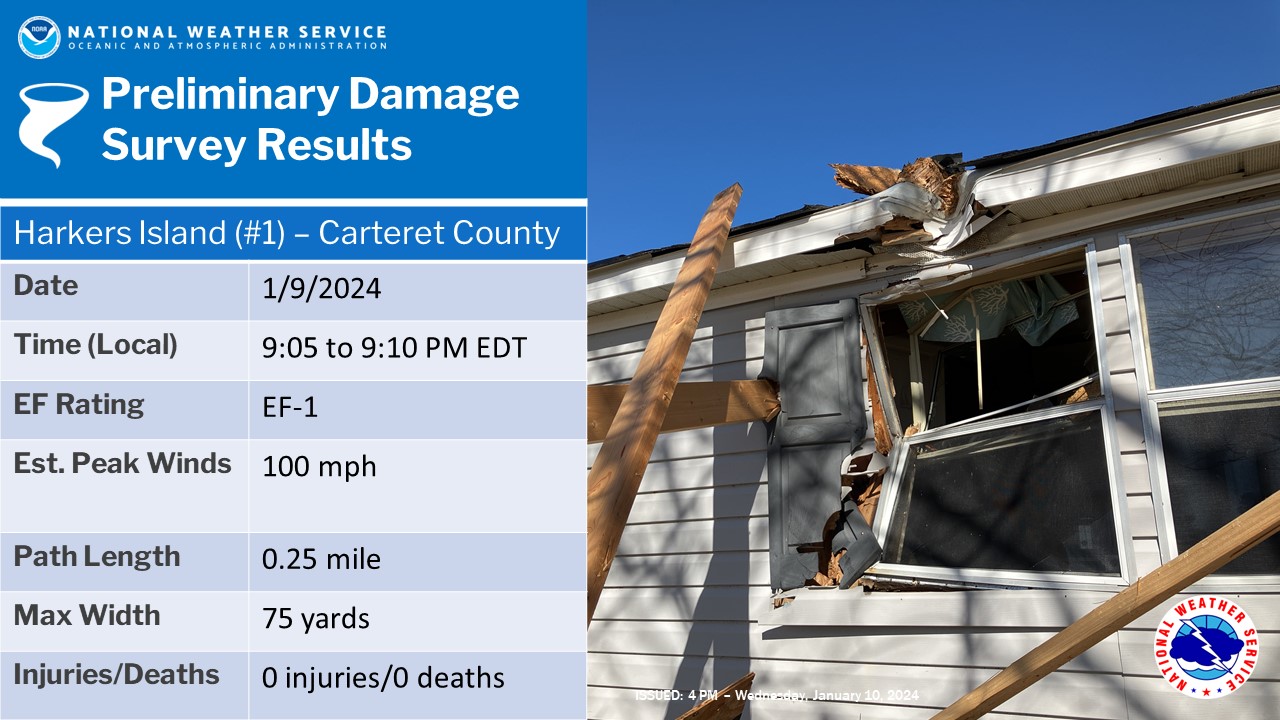
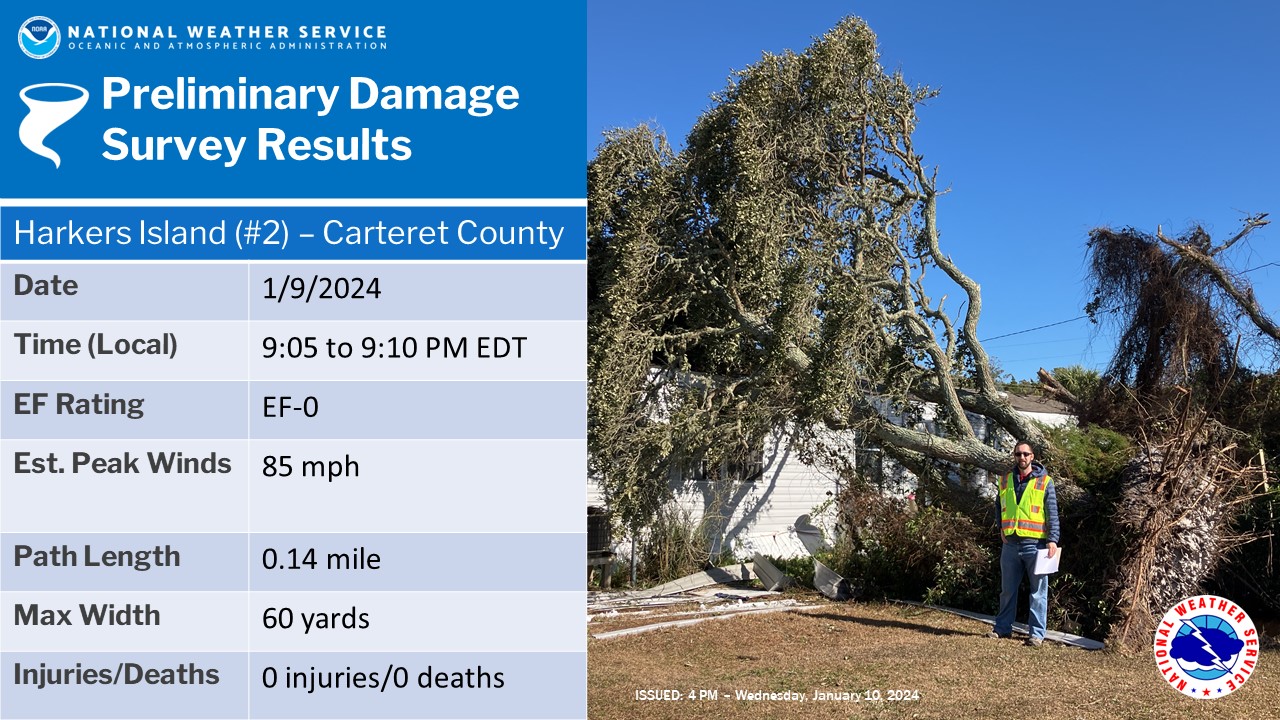
0910 PM Tornado 1 W Harkers Island 34.70N 76.58W
01/09/2024 Carteret NC Public
NWS Storm Survey confirmed an EF0 tornado in
Harkers Island with maximum sustained winds
of 85 mph, path length of 0.14 miles, and
path width of 60 yards. No injuries were
reported.
0910 PM Tornado Harkers Island 34.69N 76.56W
01/09/2024 Carteret NC NWS Storm Survey
NWS Storm Survey confirmed an EF1 tornado in
Harkers Island with maximum sustained winds
of 100 mph, path length of 0.25 miles, and
path width of 75 yards. No injuries were
reported.
0845 PM Tstm Wnd Dmg Bath 35.48N 76.81W
01/09/2024 Beaufort NC Utility Company
Tideland Electric Cooperative reported a
tree on powerlines in the Everett community
of Bath. Time based on radar.
0612 PM Tstm Wnd Gst 2 SSE Bogue 34.69N 77.02W
01/09/2024 M62 MPH AMZ158 NC ASOS
Marine Corp Air Station Bogue Field (NJM)
observed a 54 knot (62 mph) thunderstorm
wind gust.
0851 PM Tstm Wnd Gst 2 SW Bettie 34.77N 76.62W
01/09/2024 M56 MPH AMZ158 NC Public
WxFlow site in North River observed a 56 mph
(49 knot) thunderstorm wind gust.
1040 PM Tstm Wnd Gst 17 SSE Cape Hatteras Li 35.01N 75.46W
01/09/2024 M60 MPH AMZ154 NC Buoy
Diamond Shoals Buoy (41025) observed a 52
knot (60 mph) thunderstorm wind gust.
1018 PM Tstm Wnd Gst Whalebone 35.91N 75.59W
01/09/2024 M101 MPH AMZ150 NC Mesonet
Jennettes Pier WxFlow station reported a
gust of 88 kt.
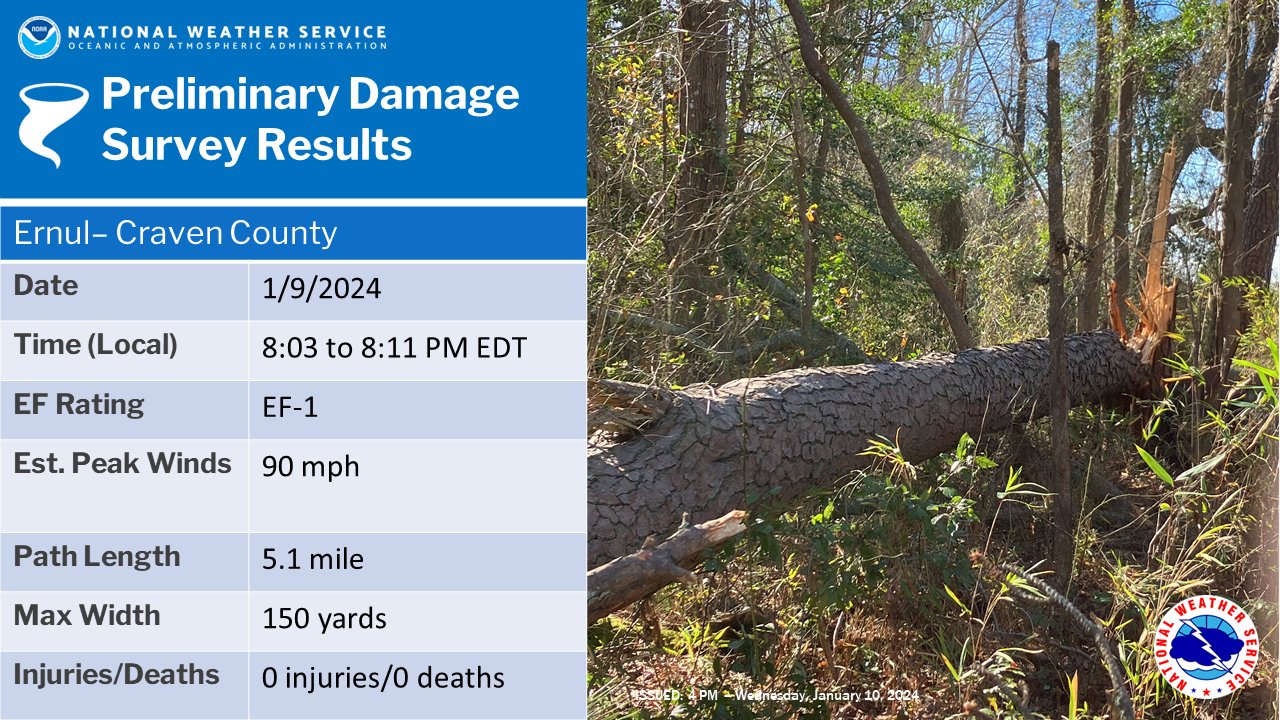
January 9th Tornadoes
Storm Survey Results
Note: Since 1950, only one other time in Eastern NC history has 3, or more, tornadoes occurred in one event during the winter months (Dec, Jan, Feb). The last time this occurred was on February 18, 2008 (4 tornadoes occurred with that event).
 |
 |
 |
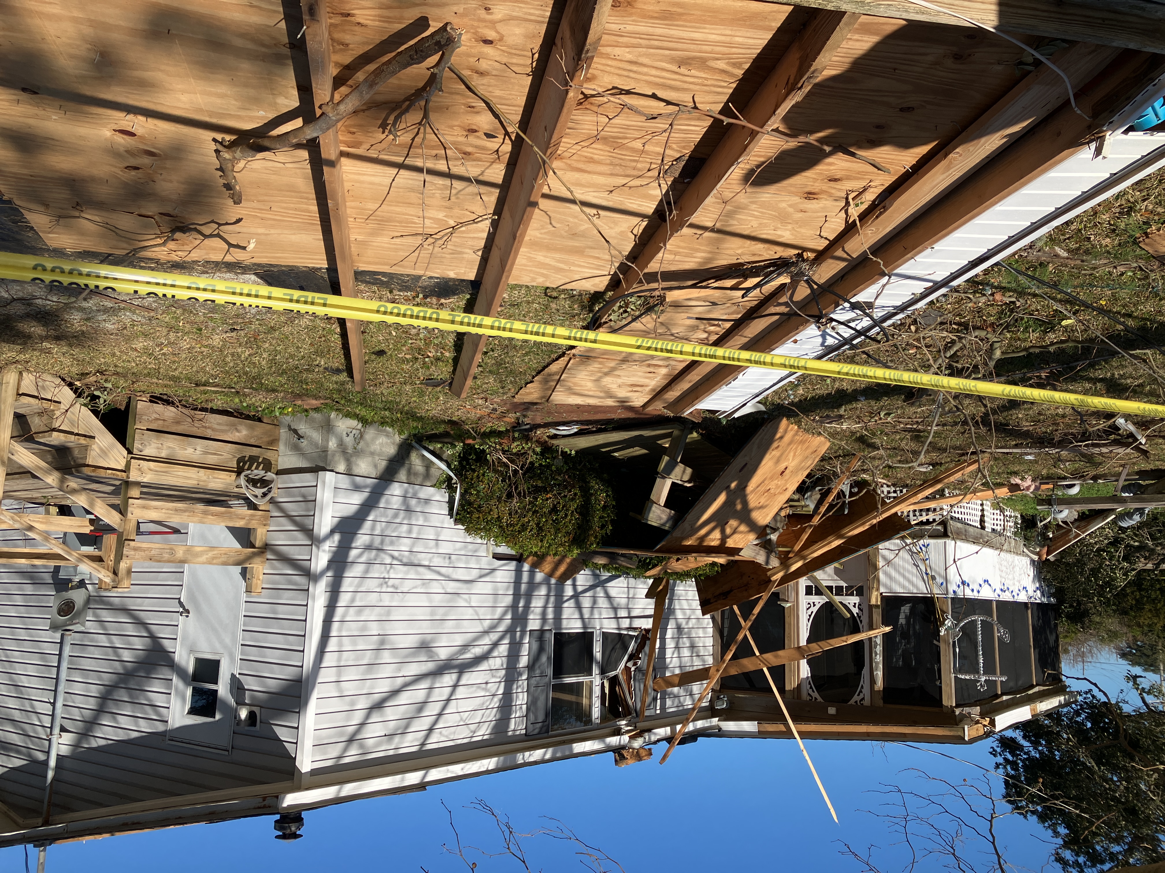
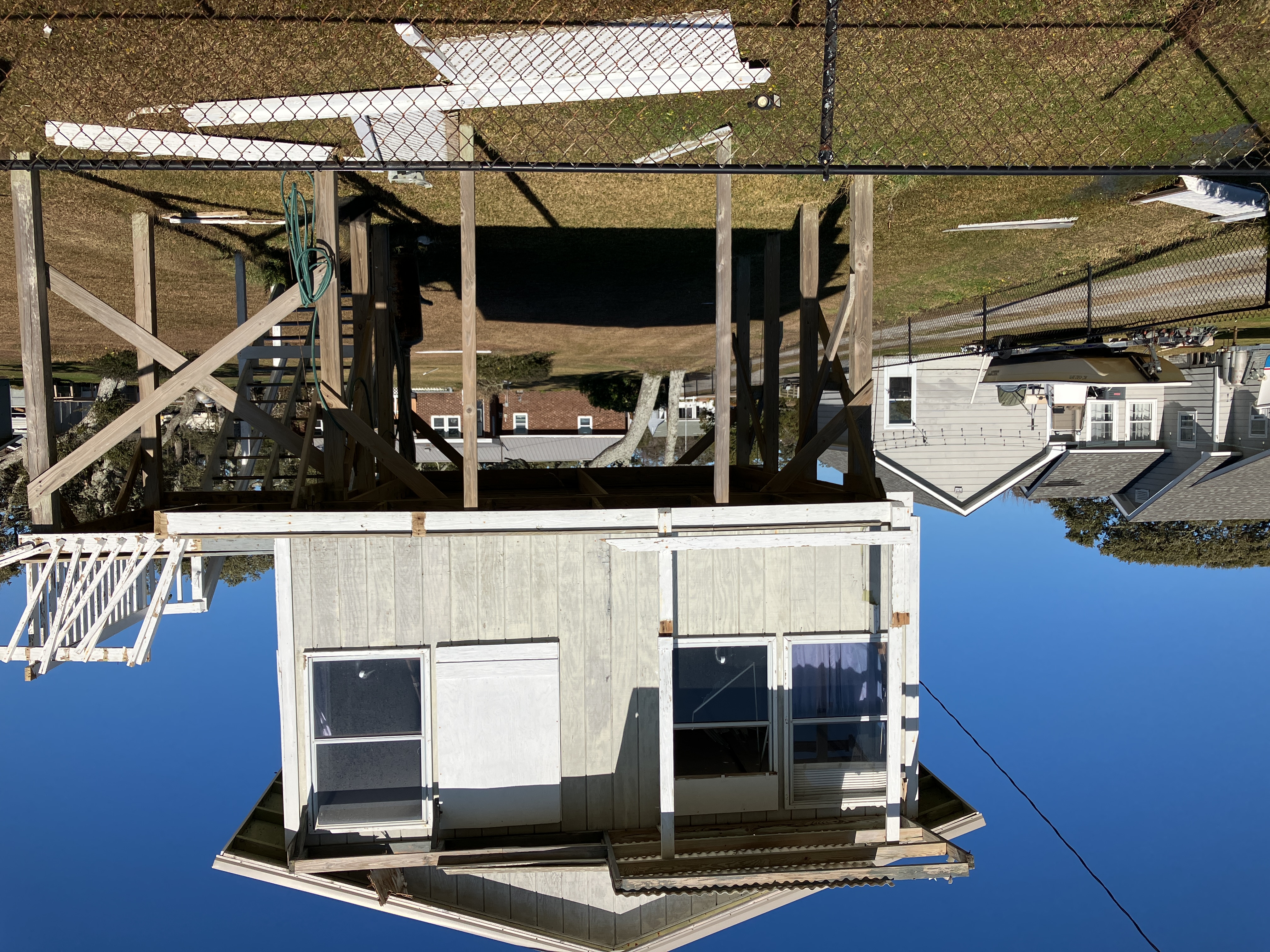
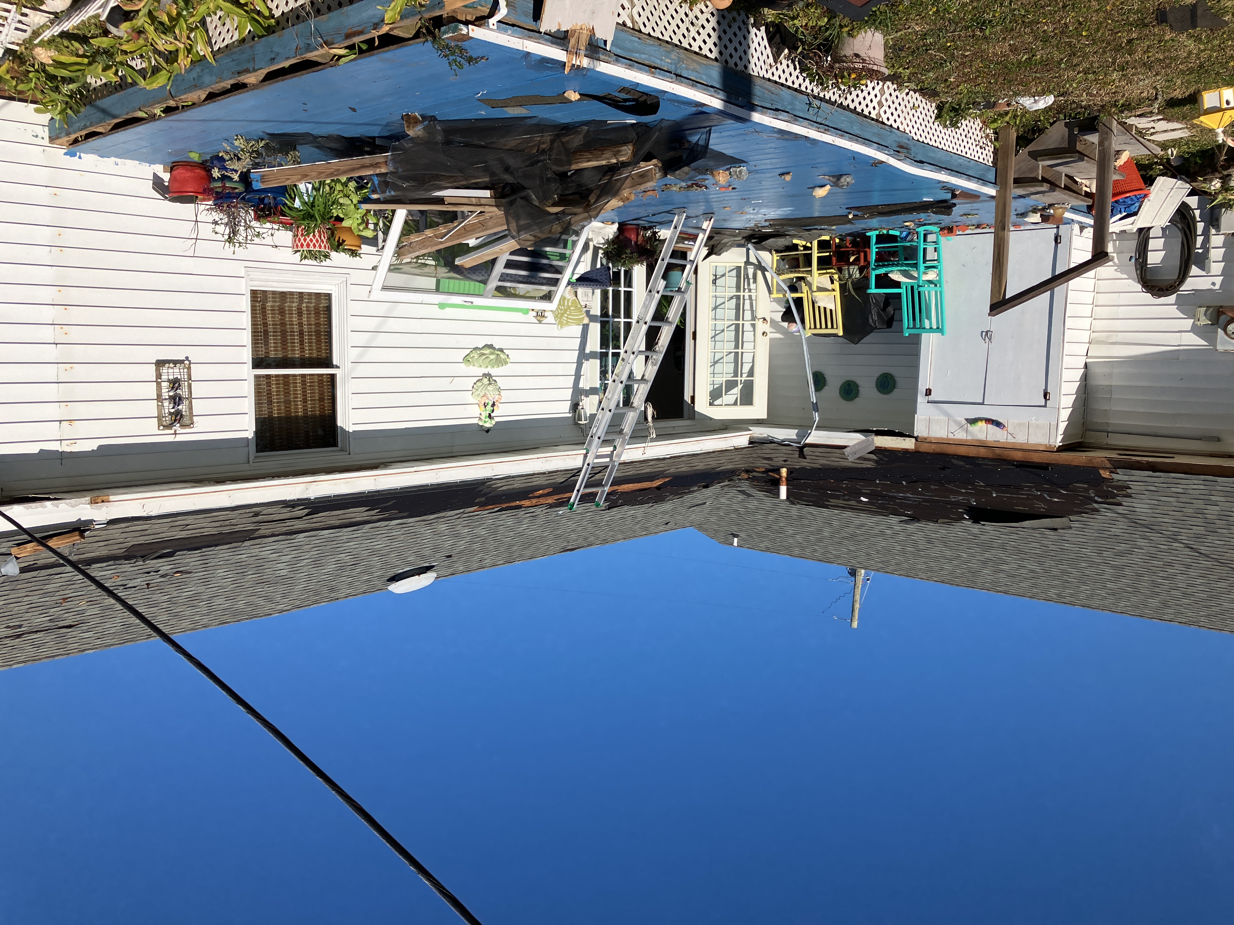
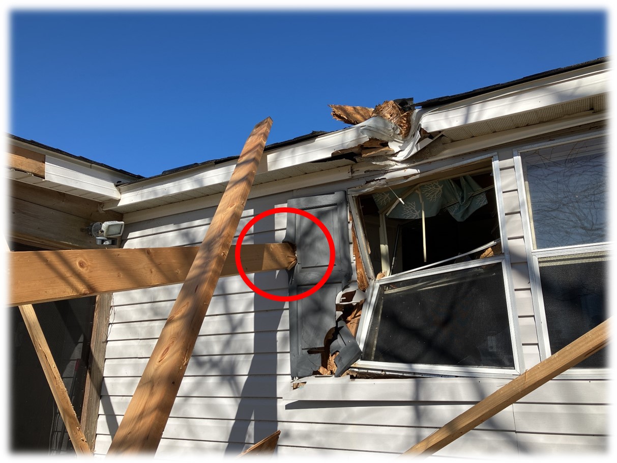
Storm Survey Pictures
 |
 |
 |
 |
 |
 |
 |
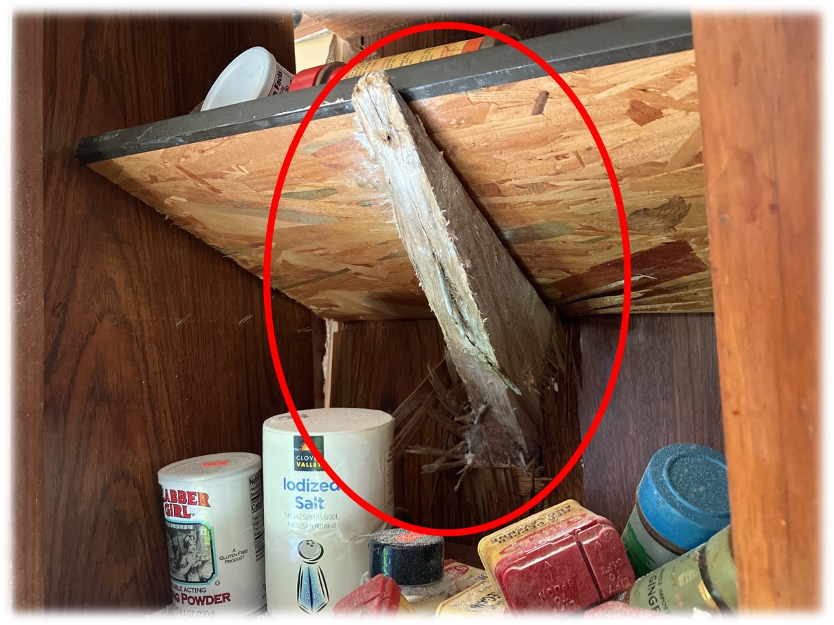 |
| This is an example of why we so often stress the importance of seeking shelter inside AND in an interior room that is away from windows or outer walls. |
Severe Weather Environment Overview
 |
 |
|
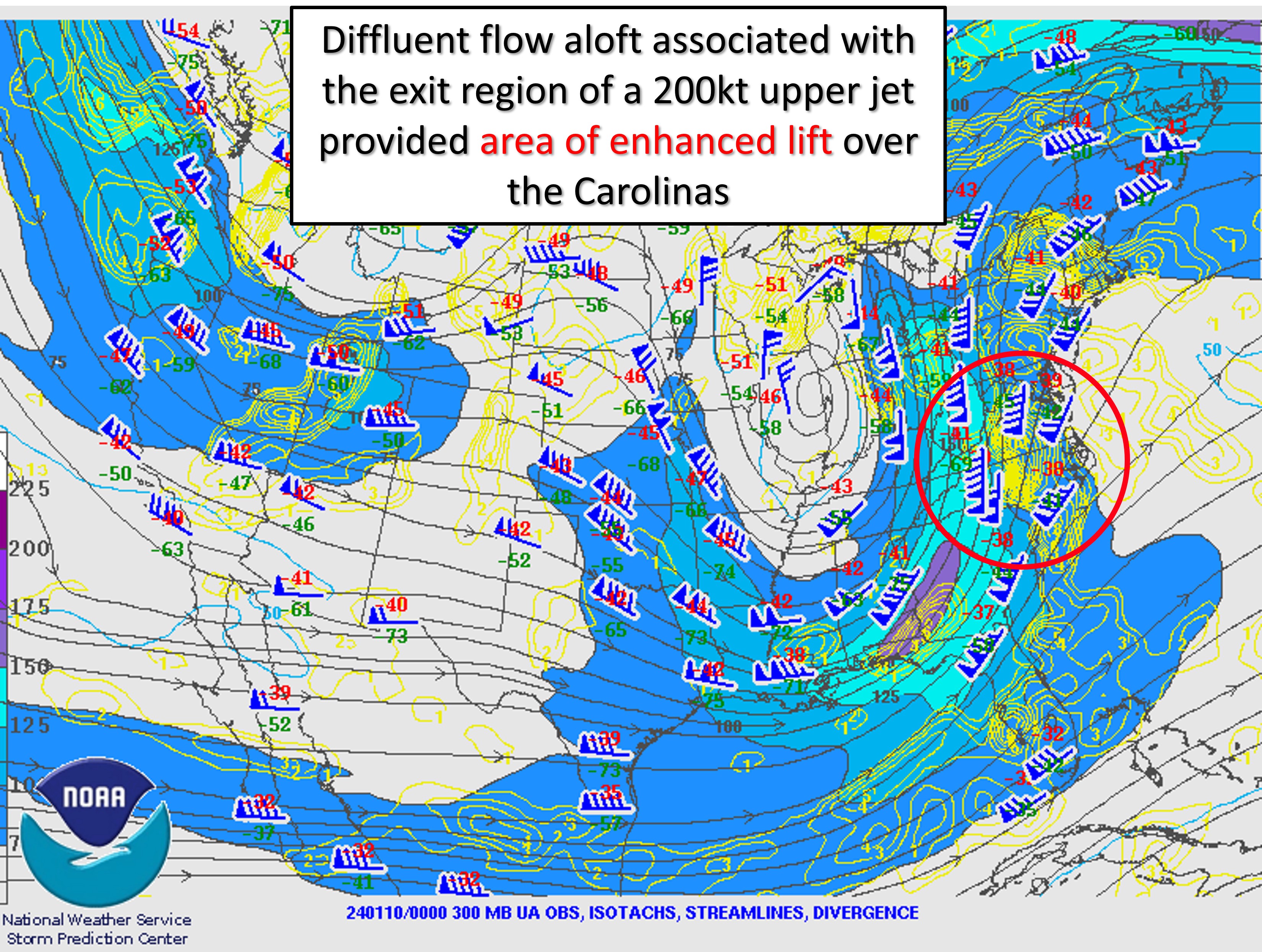
300mb Analysis |
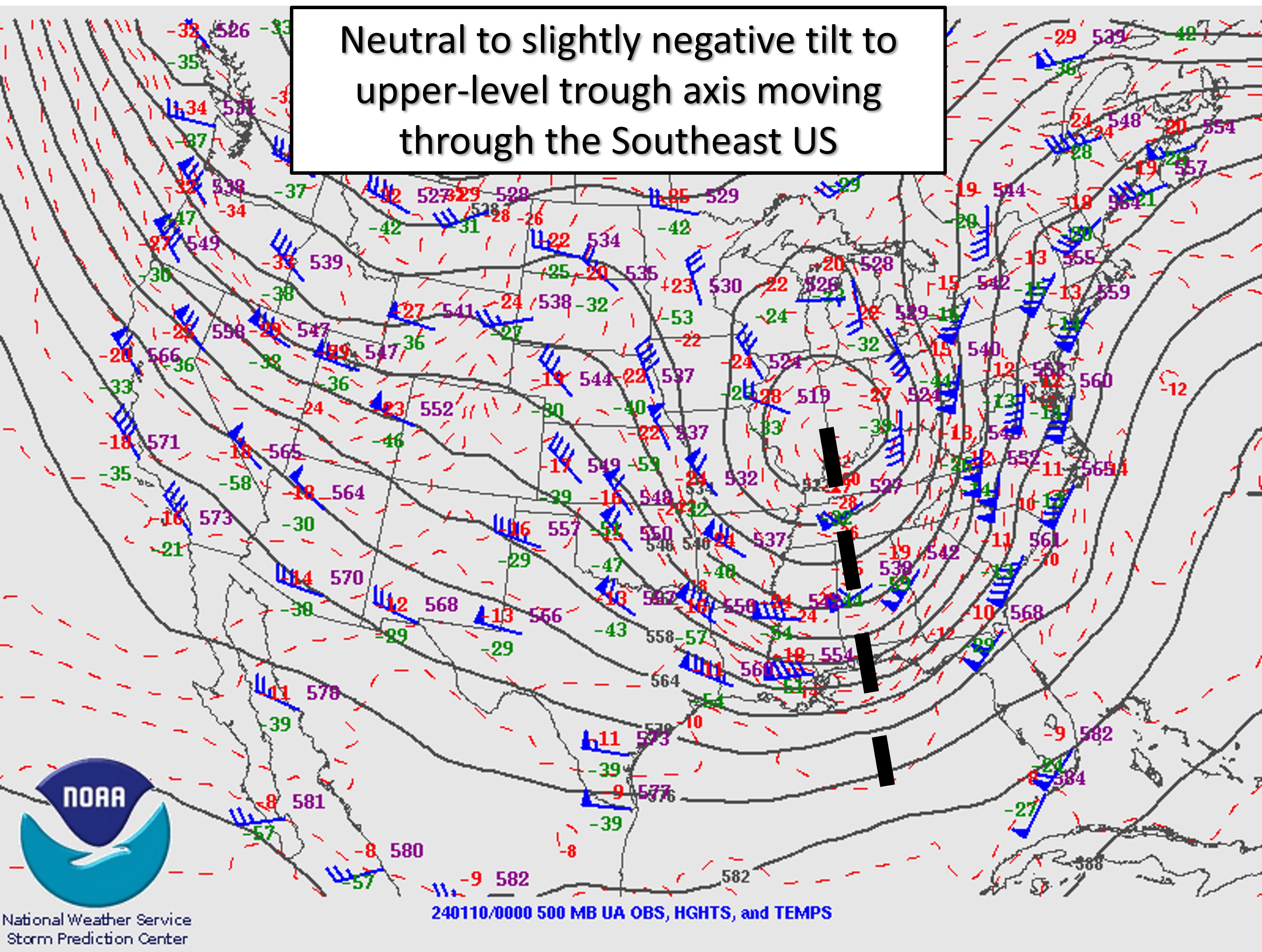
500mb Analysis |
 |
 |
|
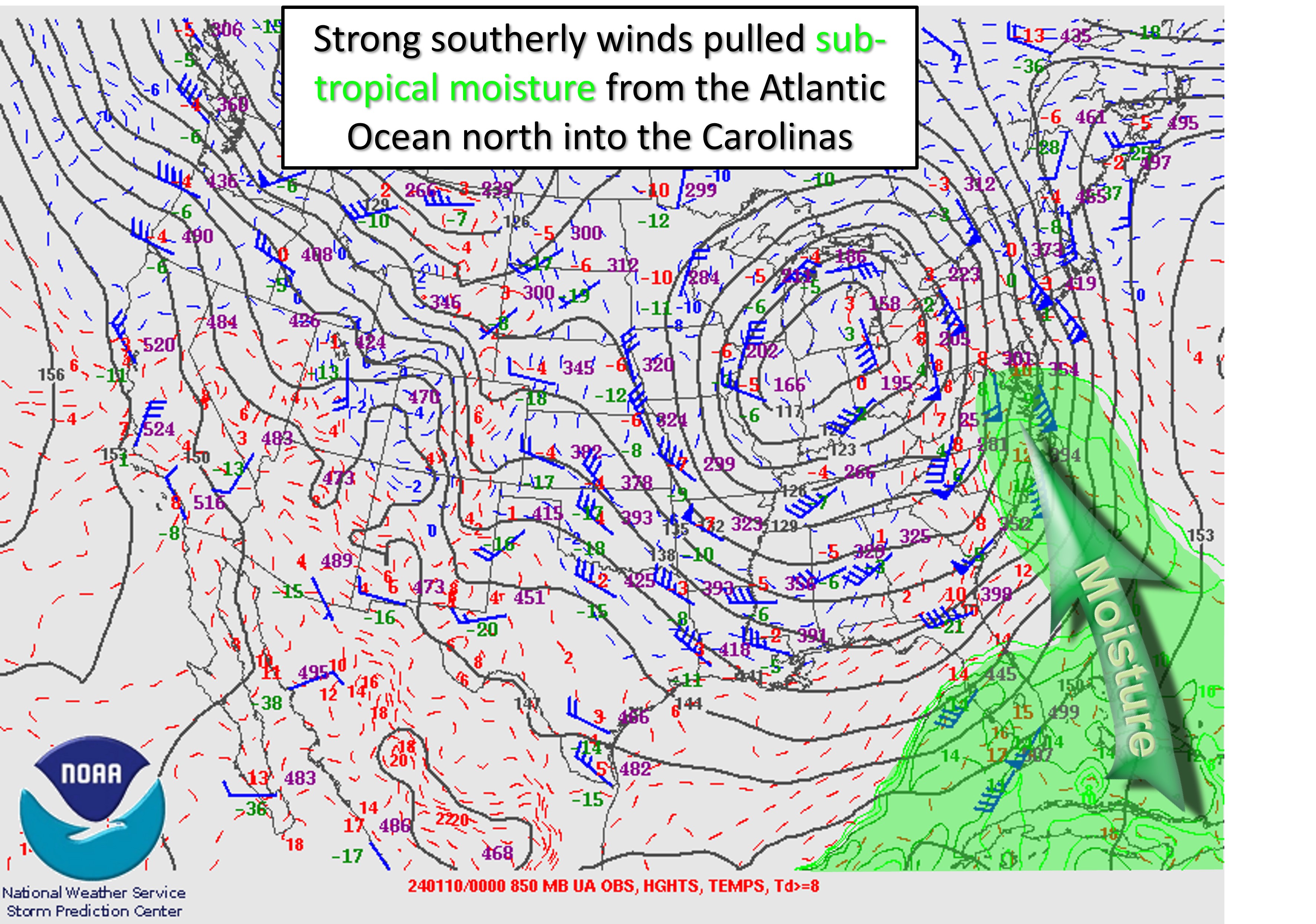
850mb Analysis |
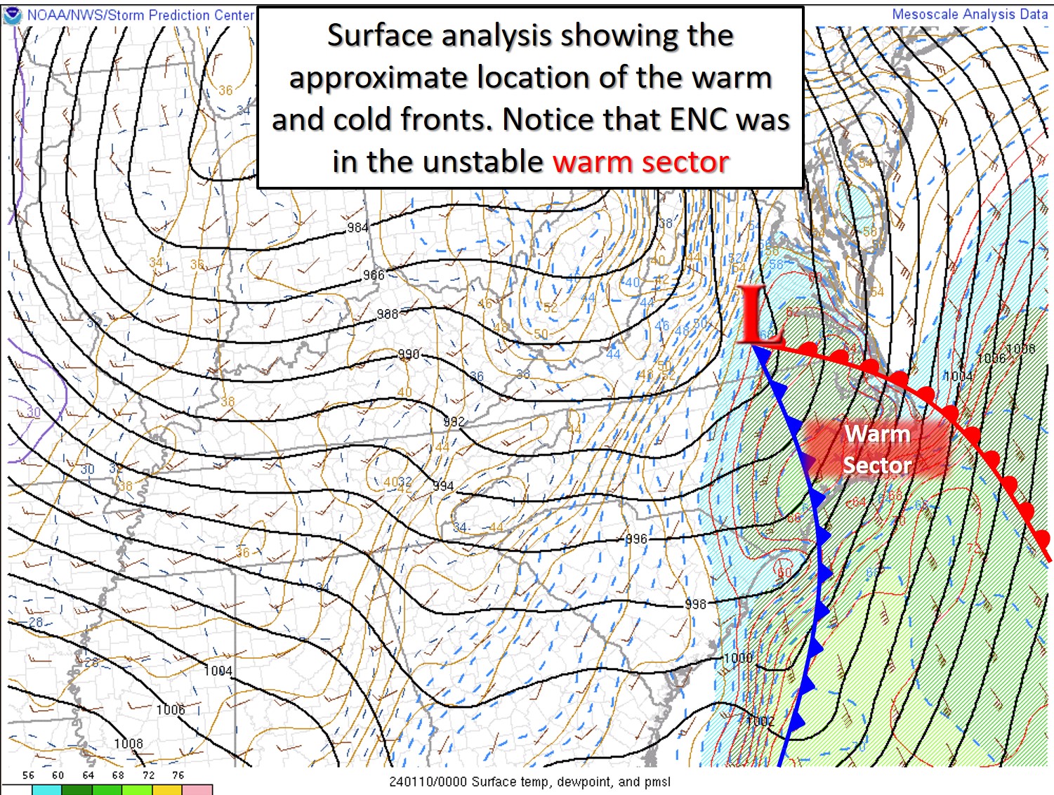
Surface Analysis |
 |
 |
|
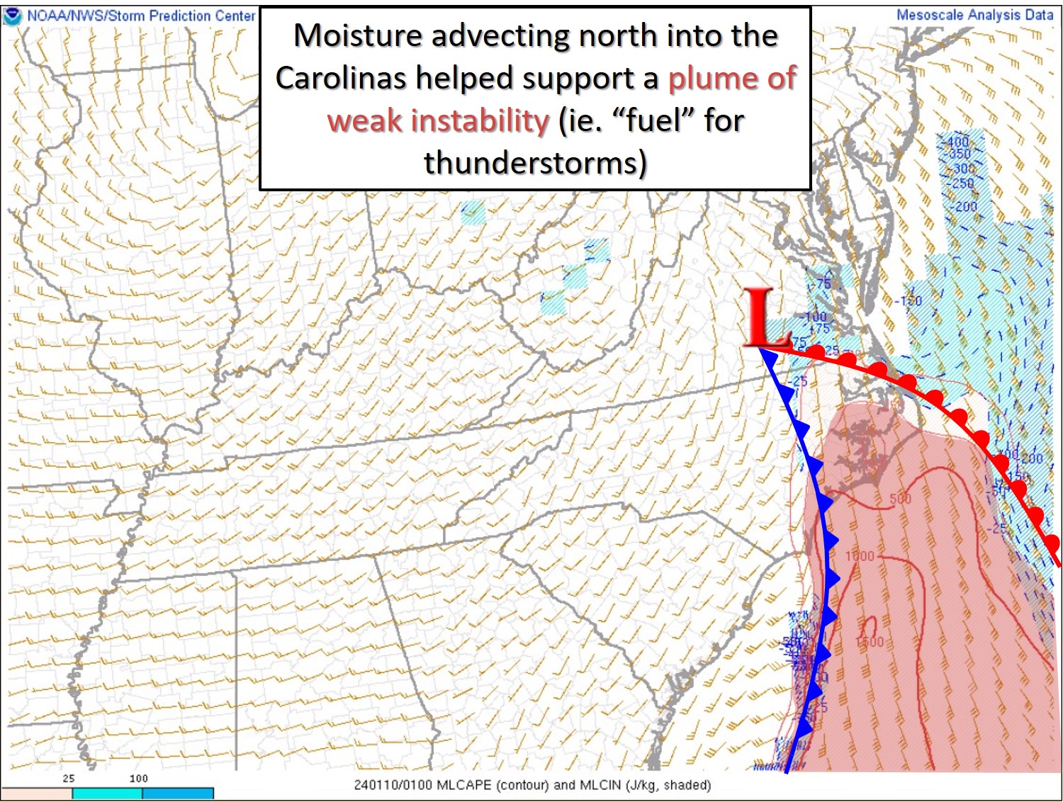
Instability (MLCAPE) |
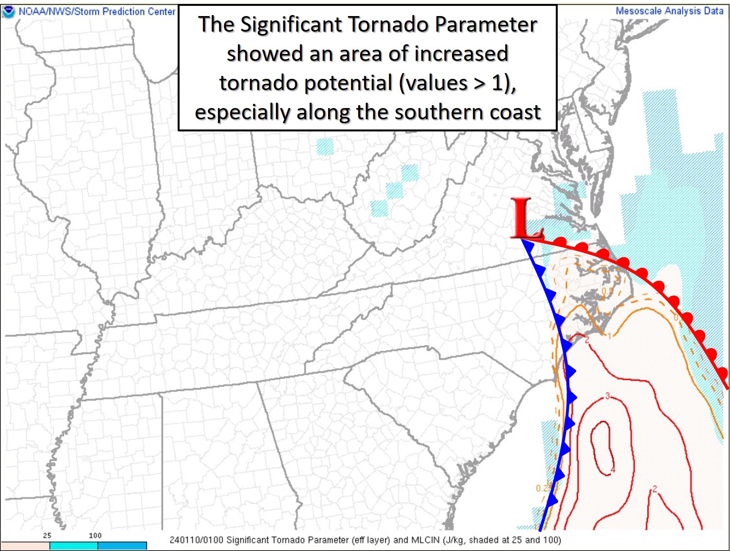
Significant Tornado Parameter (STP) |
 |
 |
|
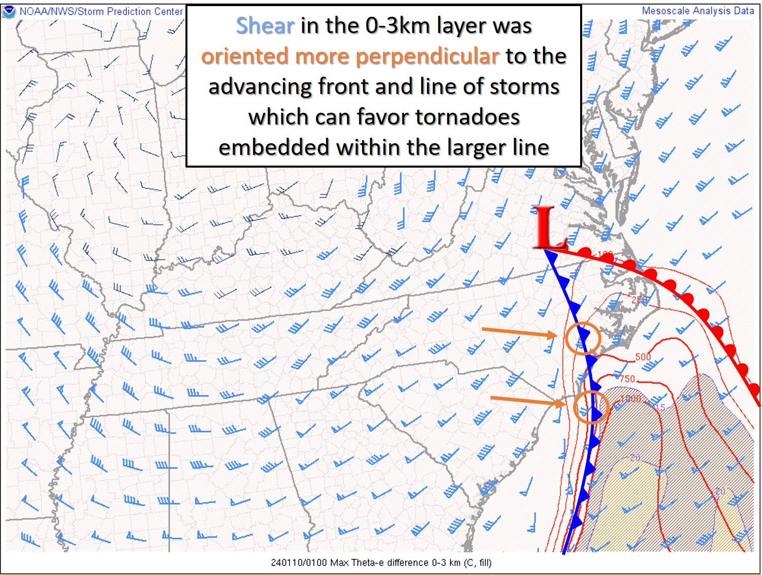
0-3km Shear |
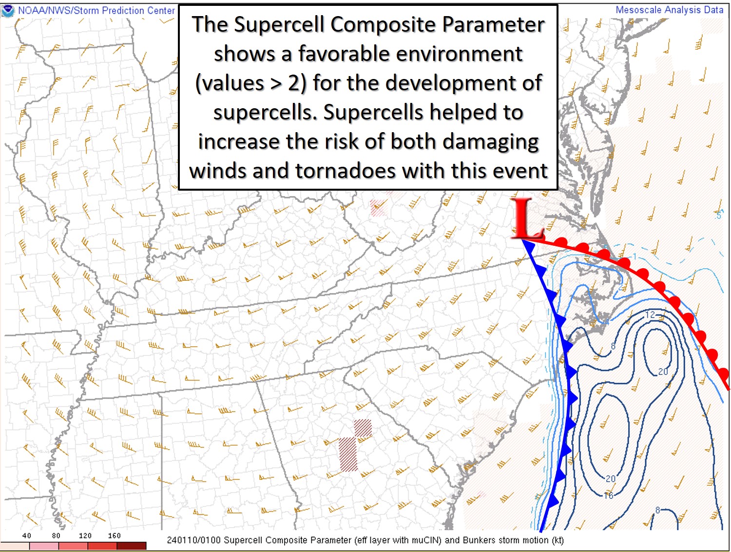
Supercell Composite Parameter (SCP) |
Wind Reports
...JAN 9-10, 2024 HIGHEST WIND REPORTS (75+ mph gusts in Red)...

Location                     Speed     Time/Date       Provider

...North Carolina...

...Beaufort County...
Washington (OCW AWOS)        48 MPH    0525 PM 01/09   AWOS
NC Fire RAWS No. 4           46 MPH    0646 PM 01/09   RAWS
Aurora 5.6 NE (Pamlico Aqua  42 MPH    0645 PM 01/09   NC-ECONET
Bath                         41 MPH    0845 PM 01/09   DAVIS

...Carteret County...
Beaufort (MRH ASOS)          69 MPH    0844 PM 01/09   ASOS
Cape Lookout CMAN            62 MPH    0800 PM 01/09   NDBC
Bogue Field (NJM ASOS)       62 MPH    0829 PM 01/09   AWOS
Fort Macon (WxFlow)          61 MPH    0905 PM 01/09   WXFLOW
North River (WxFlow)         56 MPH    0851 PM 01/09   WXFLOW
Beaufort                     55 MPH    0820 PM 01/09   CWOP
Beaufort (Duke Marine Lab)   51 MPH    0912 PM 01/09   NOS-NWLON
Newport 7.5 E                48 MPH    0817 PM 01/09   CWOP
Cape Carteret 0.6 E          46 MPH    0845 PM 01/09   CWOP
Atlantic Beach 0.4 E         44 MPH    1045 PM 01/09   CWOP
Cedar Island RAWS            43 MPH    1025 PM 01/09   RAWS
Croatan RAWS                 41 MPH    0848 PM 01/09   RAWS
Newport 10.3 ENE             40 MPH    0901 PM 01/09   CWOP
Morehead City 4.7 W          40 MPH    1200 PM 01/09   CWOP

...Craven County...
New Bern (EWN ASOS)          77 MPH    0816 PM 01/09   ASOS
Cherry Point (NKT ASOS)      63 MPH    0532 PM 01/09   AWOS
New Bern RAWS                51 MPH    0817 PM 01/09   RAWS
Havelock 0.7 NW              41 MPH    0815 PM 01/09   CWOP

...Dare County...
KHK Resort (WxFlow)          64 MPH    1033 PM 01/09   WXFLOW
Avon (WxFlow)                62 MPH    1022 PM 01/09   WXFLOW
Oregon Inlet CG (WxFlow)     60 MPH    0926 PM 01/09   WXFLOW
Rodanthe 0.6 N               59 MPH    1016 PM 01/09   CWOP
Real Slick (WxFlow)          59 MPH    1013 PM 01/09   WXFLOW
Oregon Inlet Marina          58 MPH    1024 PM 01/09   NOS-NWLON
Oregon Inlet (WxFlow)        58 MPH    0928 PM 01/09   WXFLOW
Frisco (HSE ASOS)            56 MPH    0952 PM 01/09   ASOS
ECU Coastal Studies Institut 55 MPH    0740 PM 01/09   MESOWEST
Nags Head                    55 MPH    0544 PM 01/09   CWOP
Buxton (WxFlow)              50 MPH    1021 PM 01/09   WXFLOW
Dare Bomb Range RAWS         49 MPH    0948 PM 01/09   RAWS
Dare Co Gnry Ran (2DP AWOS)  47 MPH    1003 PM 01/09   AWOS
Manteo (MQI AWOS)            47 MPH    0750 PM 01/09   AWOS
Frisco                       47 MPH    0505 AM 01/10   DAVIS
Buxton RAWS                  46 MPH    1030 PM 01/09   RAWS
Hatteras High (WxFlow)       46 MPH    1017 PM 01/09   WXFLOW
Southern Shores 1.7 NNW      45 MPH    0718 PM 01/09   CWOP
Kill Devil Hills             44 MPH    0515 PM 01/09   DAVIS
Frisco 0.3 SW                43 MPH    0630 PM 01/09   CWOP
DVI11679                     43 MPH    0805 PM 01/09   DAVIS
Kill Devil Hills             42 MPH    0330 PM 01/09   DAVIS
Manteo 0.2 E                 42 MPH    0225 PM 01/09   DAVIS
Buxton 0.7 SE                40 MPH    0945 PM 01/09   CWOP
Manteo 0.5 SSE               40 MPH    0755 PM 01/09   DAVIS

...Duplin County...
Wallace 6.4 WNW (Williamsdal 52 MPH    0730 PM 01/09   NC-ECONET
Kenansville                  50 MPH    0630 PM 01/09   CWOP
Wallace (ACZ AWOS)           45 MPH    0705 PM 01/09   AWOS
Kenansville (DPL AWOS)       41 MPH    0505 AM 01/10   AWOS

...Hyde County...
Engelhard (7W6 AWOS)         43 MPH    0930 PM 01/09   AWOS

...Lenoir County...
Kinston 2.5 NNE (Cunningham  46 MPH    0515 PM 01/09   NC-ECONET
Kinston (ISO AWOS)           45 MPH    0556 PM 01/09   AWOS

...Martin County...
Williamston (MCZ AWOS)       46 MPH    0845 PM 01/09   AWOS

...Onslow County...
Jacksonville (NCA ASOS)      78 MPH    0737 PM 01/09   AWOS
Jacksonville 1.7 NNW         77 MPH    0806 PM 01/09   CWOP
Richlands (OAJ AWOS)         51 MPH    0713 PM 01/09   AWOS

...Pamlico County...
Oriental 1.7 NE              50 MPH    0900 PM 01/09   CWOP

...Pitt County...
Greenville (PGV AWOS)        54 MPH    0605 PM 01/09   AWOS
Greenville (Dowdy Ficklen St 46 MPH    0720 PM 01/09   MESOWEST
Farmville                    46 MPH    0530 PM 01/09   DAVIS
FARMVILLE                    44 MPH    0605 PM 01/09   CWOP

...Washington County...
Tidewater Research Station   52 MPH    0545 PM 01/09   NC-ECONET
Pocosin Lakes RAWS           52 MPH    0917 PM 01/09   RAWS
Creswell 2.6 SSW             49 MPH    0945 PM 01/09   CWOP
Roper 9.8 ENE                46 MPH    0645 PM 01/09   CWOP
Plymouth 12.2 SSE            42 MPH    0558 PM 01/09   CWOP

...Maritime Stations...
Atlantic Channel (WxFlow)    102 MPH   0926 PM 01/09   WXFLOW
Jennettes Pier (WxFlow)      101 MPH   1018 PM 01/09   WXFLOW
Pamlico Sound (WxFlow)       79 MPH    1002 PM 01/09   WXFLOW
Ocracoke                     76 MPH    0941 PM 01/09   WXFLOW
Duck Pier                    69 MPH    0948 PM 01/09   NOS-NWLON
Diamond Buoy (41025)         67 MPH    0940 PM 01/09   NDBC
Alligator River Br (WxFlow)  67 MPH    0914 PM 01/09   WXFLOW
Croatan Sound (WxFlow)       65 MPH    1019 PM 01/09   WXFLOW
Duck Pier                    64 MPH    0648 PM 01/09   NOS-NWLON
Onslow Bay Buoy (41064)      63 MPH    0708 PM 01/09   NDBC
Frisco Woods (WxFlow)        60 MPH    0955 PM 01/09   WXFLOW
Avon Sound (WxFlow)          55 MPH    1030 PM 01/09   WXFLOW
Crab Point (Wx Flow)         48 MPH    0856 PM 01/09   WXFLOW
Pictures/Social Media
Damage to gas station at intersection of US Hwy 70 and Marshallberg Rd in Smyrna, power lines down across the road as well. @NWSMoreheadCity @ZachHolderWx #encwx pic.twitter.com/oXiXXjpUQw
— David Lilley (ENCWX) (@mesovorthunter) January 10, 2024
Askin, NC pic.twitter.com/jeasEc7Dcy
— alinks85 (@alinks85) January 10, 2024


.png) Surf Forecast/Rip Currents
Surf Forecast/Rip Currents Tropical Weather
 Map View
 Weather Hazard Briefing (when applicable)
 Forecaster Discussion
 Marine
 Text Products
.png) Skywarn
Skywarn Submit Storm Reports