January 30th-31st, 2013: Strong Cold front with Damaging Winds
Event Overview -
On Wednesday night, January 30th and 31st, a strong cold front crossed eastern North Carolina, producing destructive wind gusts ahead of and along the front. Wind gusts reached 45 to 60 mph leaving trees down, homes and property damaged, and many without power across the area.
Synoptic Overview –
A potent upper level trough across the central US slowly migrated eastward as the associated surface low continued to deepen. Strong warm air advection developed ahead of the front Wednesday as high pressure shifted offshore. In response to this, a Wind Advisory was posted across the area Wednesday through the overnight hours. Partly cloudy skies during the day with some surface heating allowed winds to become elevated (20kts with higher gusts) well ahead of the front. Clouds increased through the late afternoon which reduced mixing allowing winds to subside a bit. With southerly flow advecting across the cool sea surface temperatures (lower 50s), the atmosphere was stable ahead of the front. With Convective Available Potential Energy (CAPE) values around 100-200 J/kg and low Lifted Index values, instability was low.The low level jet (50kts) coupled with the upper level jet (140kts) aloft would yield ample lift and an organized line of precipitation. The column shear was unidirectional, with the possibility of tornadoes limited. With such a strong low level jet, anticipated heavy precipitation would bring strong winds aloft to the surface by way of momentum transfer. Therefore, the main area of concern was the potential for destructive winds given such impressive wind shear. Ample moisture was never in question with this system since the southerly flow was tapping into the Gulf of America moisture allowing precipitable water values to rise to around 1.75” (over 2 standard deviations above climatology for the month of January). The Storm Prediction Center (SPC) did have Eastern NC in a Slight Risk days in advance. Although the tornado threat was low, SPC did issue a Tornado Watch across the area a few hours before the main line arrived. With such strong shear, any localized area of spin could produce a weak tornado.
There were 7 Severe Thunderstorm Warnings issued and another 6 Special Marine Warnings issued as the front crossed the area. There were no missed events and all but one warning were verified.
Figure Overview –
Below are a series of figures that help illustrate the event starting from the morning before the front arrived through the overnight hours as the front moved offshore. A deep mid and upper level trough anchored across the central CONUS early Wednesday morning with an impressive jet signature noted at 250mb (Figure 1 and 2). The low levels were becoming saturated through the day as strong southerly flow was bringing Gulf of America (GOM) moisture through the Carolinas (Figure 3). SPC had placed the Carolina’s in a Slight Risk for convection well before the system was supposed to arrive (Figure 4a). With ingredient not conducive for Tornadogenesis across the area, SPC placed our area in a less than 2% probability of Tornadoes (Figure 4b). Damaging winds was the main threat with most of the area in a 15-30% chance of damaging wind outlook issued by SPC (Figure 4c). By Wednesday evening, the front was crossing the Appalachians and heading toward the east coast (Figure 8). The upper level jet was starting to become more defined and the diffluence zone aloft was collocated across Eastern NC (Figure 5 and 6). This would aid in ample lift ahead and along the surface cold front. The low levels were continuing to become moist with dew point increasing under southerly flow. Based on the upper air analysis, it clear that the shear is unidirectional. This can also be observed through the VAD wind profile (Figure 7). With unidirectional flow and very little instability, tornadoes have a hard time developing. As the front approached, winds were steadily increasing as the low levels were very well mixed (Figure 8). Based on the Skew-T analysis and VAD wind profile, the 60kt low level jet (LLJ) could enable any heavy showers to bring strong gusty winds to the surface. The progression of the cold front and observations through the event can be seen in Figure 9. The main front came through Eastern NC between 06z-10z Wednesday night/Thursday morning. A map of all the local storm reports (LSR) across the southeast and mid-Atlantic highlights the damage this potent and sharp cold frontal system created (Figure 9). A list of individual LSRs across our area can be here with an interpolated map of these reports (Figure 10).
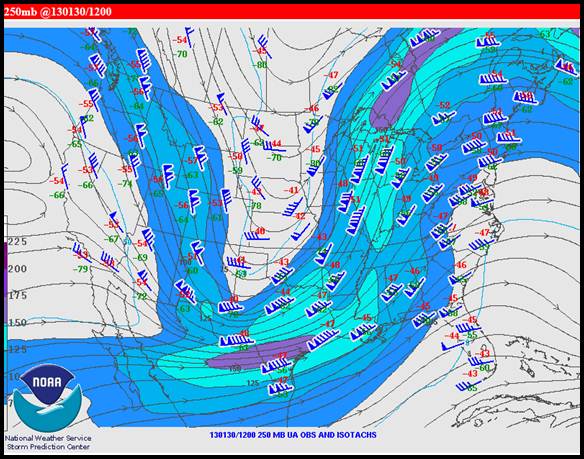
Figure 1. Upper Air map at 250mb of the upper level jet structure the morning before the event.
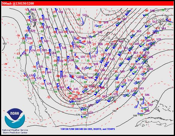
Figure 2. Upper Air map of 500mb of Heights and Temps the more before the event.
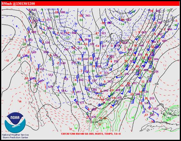
Figure 3. Upper Air map at 850mb of Heights, Temps and Dew points the morning before the event.
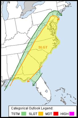
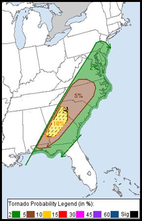
Figure 4a. SPC placed Eastern NC in a slight risk for severe weather; Figure 4b. Tornado probability less than 2%.
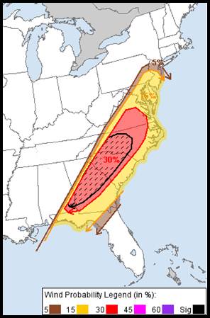
Figure 4c. Severe Wind Probability around 15-30% across much of Eastern NC.
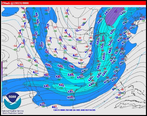
Figure 4. Upper Air map at 250mb of the upper level jet structure that evening as the front approached the area.
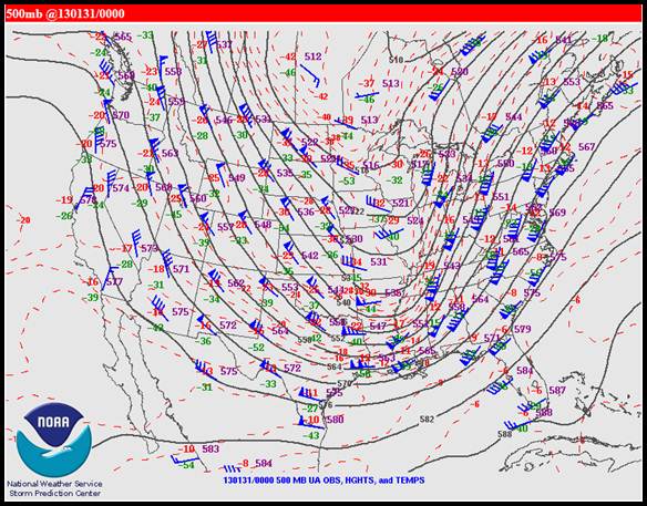
Figure 5. Upper Air map of 500mb of Heights and Temps that evening as the front approached the area.
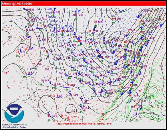
Figure 6. Upper Air map at 850mb of Heights, Temps and Dew points the evening as the front approached the area.
Figure 7. Wind Profile at MHX as the front approached between 07-08Z
Figure 8. LAPS Sound at 03Z as the front crosses central NC.
Figure 9. Loop of the 0.5 degree reflectivity and observation from 06-09z.
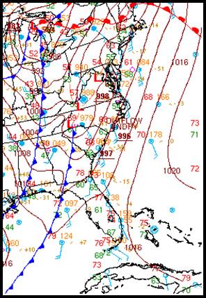
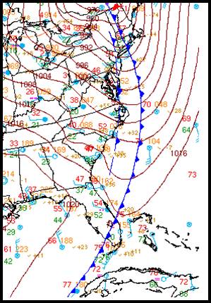
Figure 8. Surface observations with frontal analysis at 7 pm January 30 (left) and 7 am January 31 (right).
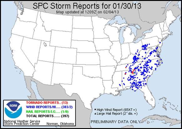
Figure 9. Local Storm Reports the morning of the 30th through the morning of the 31st (as the front moved offshore).
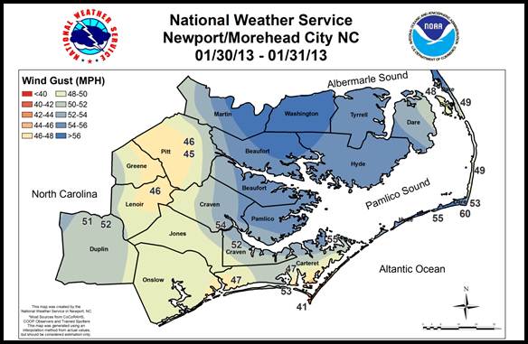
Figure 10. An interpolation of non-thunderstorm and thunderstorm wind gusts.
Case Study Team:
Lara Pagano


.png) Surf Forecast/Rip Currents
Surf Forecast/Rip Currents Tropical Weather
 Map View
 Weather Hazard Briefing (when applicable)
 Forecaster Discussion
 Marine
 Text Products
.png) Skywarn
Skywarn Submit Storm Reports