Event Overview
A strengthening area of low pressure, which developed off the northeast coast of Florida, then moved well offshore of the Carolina coast, produced a swath of heavy snowfall across mainly coastal sections of Eastern North Carolina during the late morning and afternoon hours of Saturday January 22, 2011. Areas from Carteret and southern Craven counties northeast across Mainland Hyde County and the southern Outer Banks received anywhere from 3 to as much as 7 inches of snowfall (Figure 1). Snowfall rates of 1 to 2 inches/hour were reported in the heavier bands. Frisco, on the southern Outer Banks, received 6 inches of snow, the most snowfall at that location since January 23, 2003. This event was unusual in that it affected only the Newport/Morehead City (MHX) County Warning Area (CWA) and not the adjacent Wilmington (ILM) and Wakefield (AKQ) areas. Like the event of January 10, 2011, no snow was observed over the northwestern half of the CWA (Figure 2). This event presented several forecast challenges, which are highlighted below.
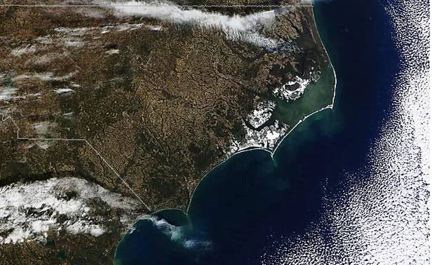
Figure 1. Visible satellite image from Sunday January 23 following snow event of Saturday January 22.
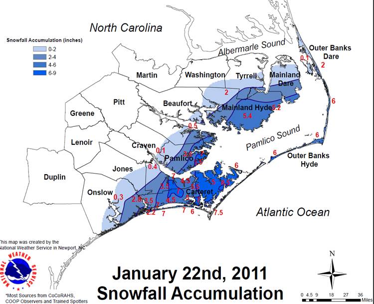
Figure 2. Snowfall Accumulations from January 22, 2011 snowstorm. Carteret, Pamlico, Mainland Hyde and Outer Banks Dare Counties received the heaviest snowfall amounts.
FORECASTER CHALLENGES
1. This event developed offshore and affected only the Newport/Morehead City (MHX) CWA (County Warning Area).
2. There was little upstream surface observations and radar data to observe, as the system affected only near-coastal areas.
3. Snowfall arrived faster than predicted by models and heavy snowfall developed rather quickly. Determining the best model QPF forecasts were difficult given model inconsistencies.
Synoptic Overview
A deep 500 mb trough moved east from the Central United States with its axis extending from the Ohio Valley to the Central Gulf Coast by early Saturday morning January 22 (Figure 3). Strong shortwave energy rounding the base of this trough led to cyclogenesis off the East Coast of Florida by 12Z Saturday morning. (Figure 4). The low then quickly moved northeast well off the North Carolina coast. Light precipitation moved onshore over Carteret County and the southern Outer Banks by 13Z (9 am) Saturday morning (Figure 5). The 12Z Newport/Morehead City sounding (Figure 6) was dry initially above the surface, but the atmosphere quickly saturated as light precipitation moved onshore during the morning. As the low continued to deepen, widespread snow overspread the southern coastal sections, eastern sound counties, and southern Outer Banks by 18Z (1 pm) with snowfall rates of 1 to 2 inches per hour observed (Figure 7).
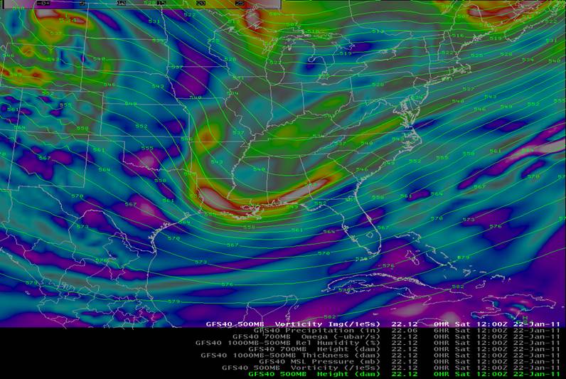
Figure 3. 500 mb Heights/Vorticity 12Z (7 am) Saturday January 22, 2011.
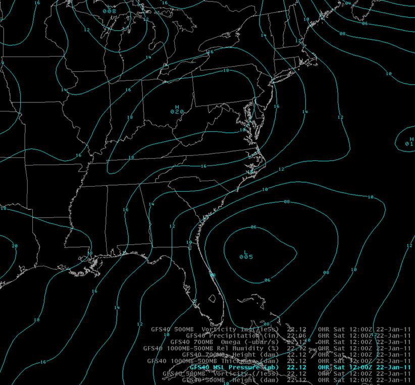
Figure 4. A 1020 mb high pressure center to the north provided cold air for Eastern North Carolina as low pressure formed off the northeast coast of Florida and moved well off the North Carolina coast.
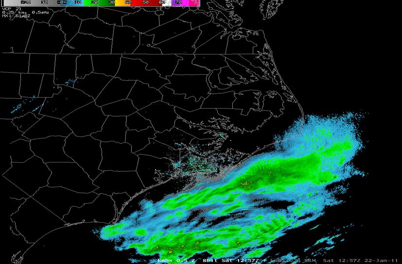
Figure 5. Light snowfall approaches the southern North Carolina coast at 13Z (9 am) Saturday morning January 22, 2011.
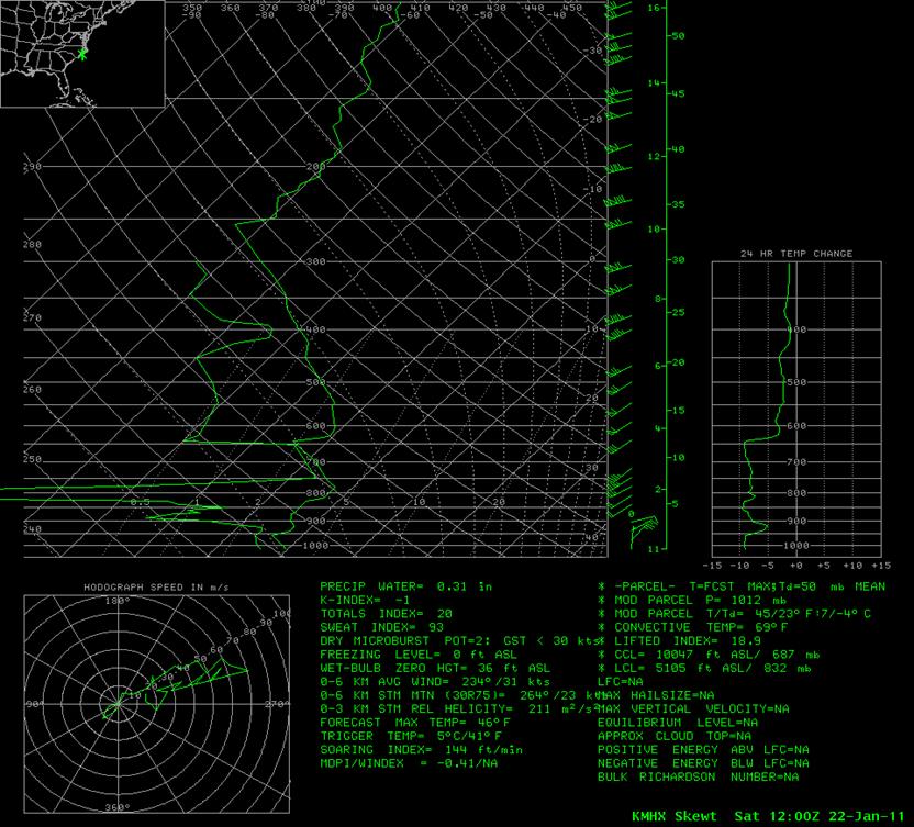
Figure 6. The 12Z Newport/Morehead City MHX Sounding shows plentiful dry air above 950 mb, but the atmosphere rapidly moistened as light precipitation moved onshore.
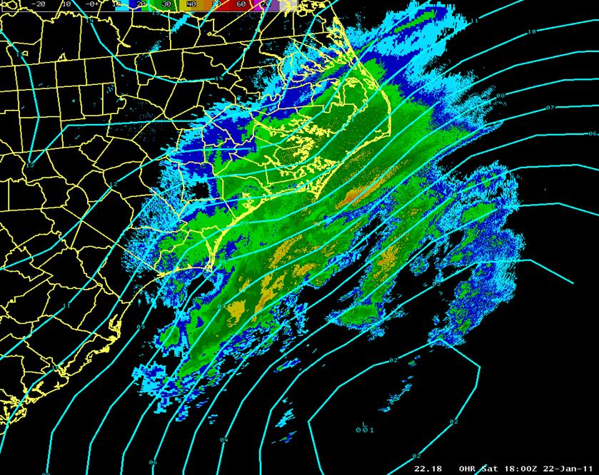
Figure 7. At 18Z (1 pm) Saturday January 22, 2011, low pressure well east of Charleston, SC is strengthening with widespread snow covering much of coastal Eastern North Carolina.
Frontogenesis is a very important and common atmospheric process that refers to a change in the magnitude and orientation of a thermal (temperature) gradient at a level or in a layer due to horizontal changes in the total wind. This change alters thermal wind balance, which forces a vertical motion response in the atmosphere which can result in mesoscale bands of enhanced snowfall. The 850-700 mb Frontogenesis forecast at 18Z Saturday is illustrated below (Figure 8). Note the enhanced axis of frontogenesis near the coast where higher values of snow were observed. Heavy snow banding was observed on radar around 3 pm or 20Z (Figure 9).
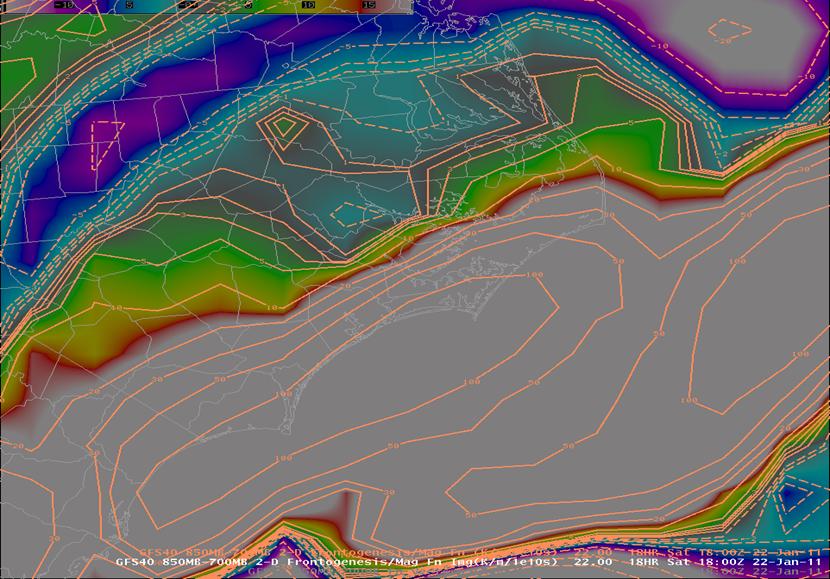
Figure 8. 850-700 mb Frontogenesis magnitude valid 18Z ( 1pm) Saturday January 22, 2011.
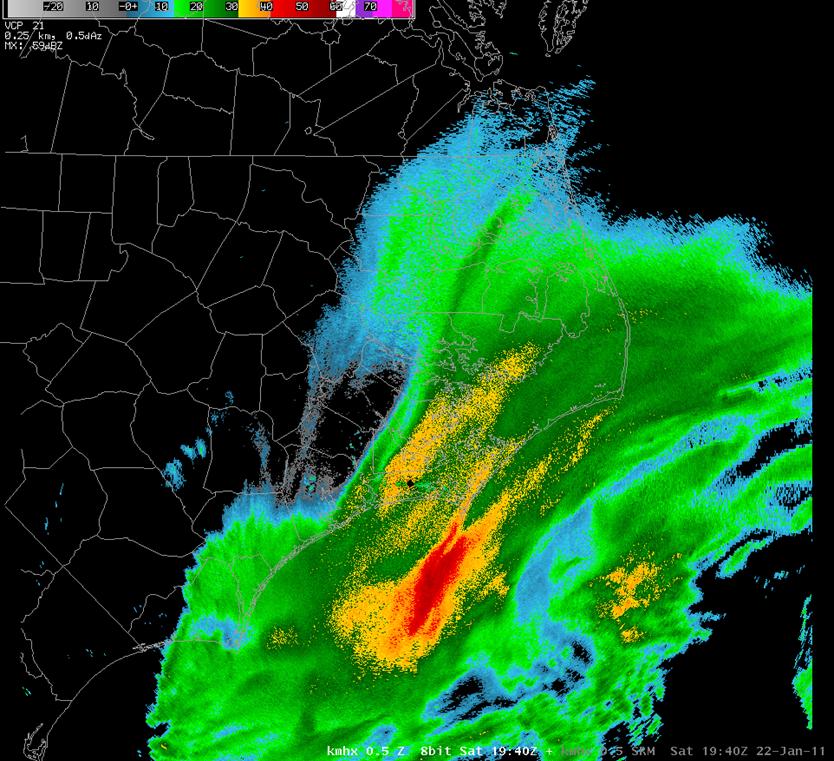
Figure 9. Radar Reflectivity from the Newport/Morehead City (MHX) radar at 1940Z Saturday January 22, 2011 showing heavy snow bands near the coast.
The precipitation ended over the central Outer Banks by early evening as the low accelerated to the east-northeast away from the region. Very cold temperatures followed Saturday night as skies cleared over the fresh snow. The minimum temperature at the Newport/Morehead City Forecast Office dropped to 9 degrees Sunday morning, the second coldest low ever recorded at the site since the station moved from Cape Hatteras in 1994.
Models/Forecasts
Forecast challenges for this system included:
1. This event developed offshore and affected only the Newport/Morehead City (MHX) CWA (County Warning Area).
2. There were no upstream surface observations and radar data to observe, as the system affect only near-coastal areas.
3. Snowfall arrived faster than predicted by models and heavy snowfall developed rather quickly. Determining the best model QPF forecasts were difficult given model inconsistencies.
With regards to the position and strength of the surface low pressure, the models were fairly similar, as the 00Z Saturday January 22th run of both the GFS (Figure 10) and NAM12 (Figure 11) both showed the low well east of the South Carolina coast, with the NAM12 being a bit stronger. The GFS verified better as of 18Z Saturday showing a 1000 mb low center, with a 1001 mb center observed well east of South Carolina.
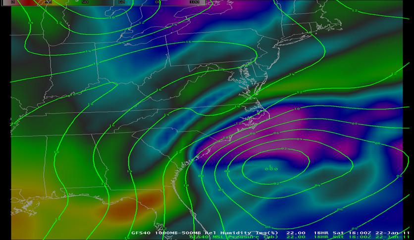
Figure 10. GFS model PMSL forecast verifying at 18Z (1 pm) Saturday January 22, 2011.
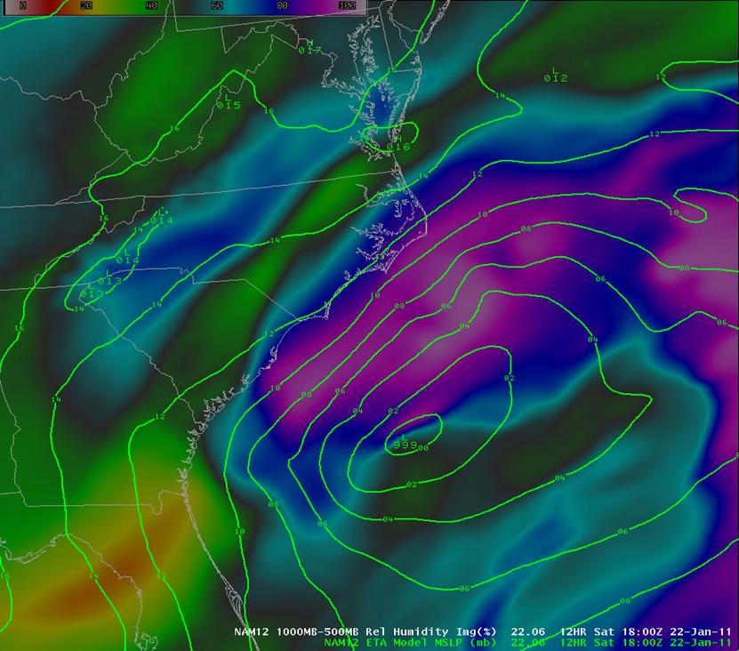
Figure 11. NAM12 PMSL forecast verifying at 18Z (1 pm) Saturday January 22, 2011.
Despite the relatively similar forecasts in the position and strength of the surface low, inconsistency in the model QPF/snow amount forecast developed. For example, the 00Z Saturday run of the GFS a band of 2 to 4 inch snow amounts along the southern North Carolina coast (Figure 12), while the 06Z NAM12 forecast, issued 6 hours later, showed little snow in the same area (Figure 13).
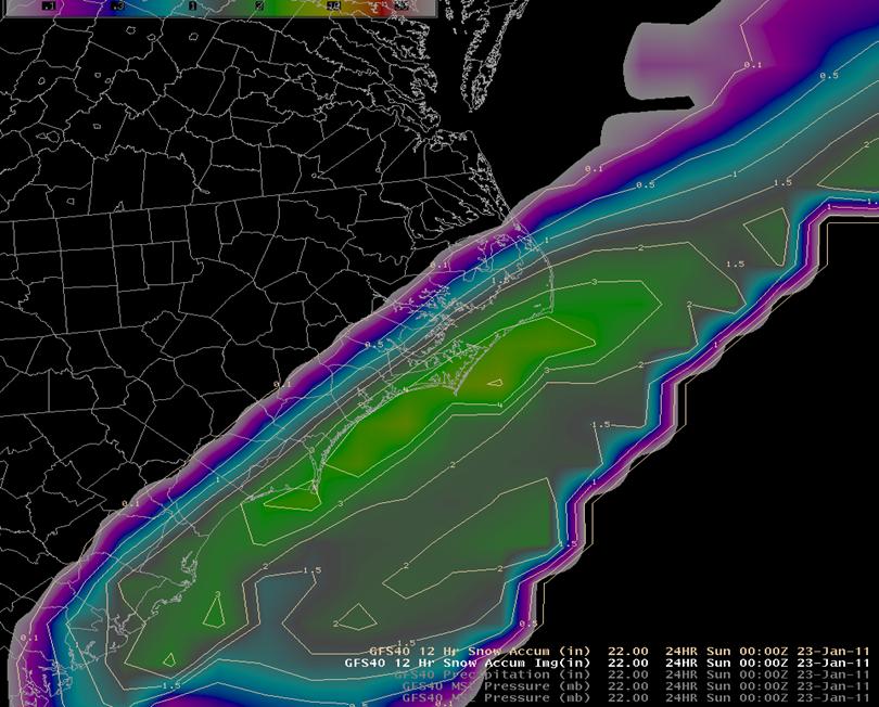
Figure 12. The 00Z GFS forecast of 12 hour snowfall amounts ending at 00Z (7 pm) Saturday night.
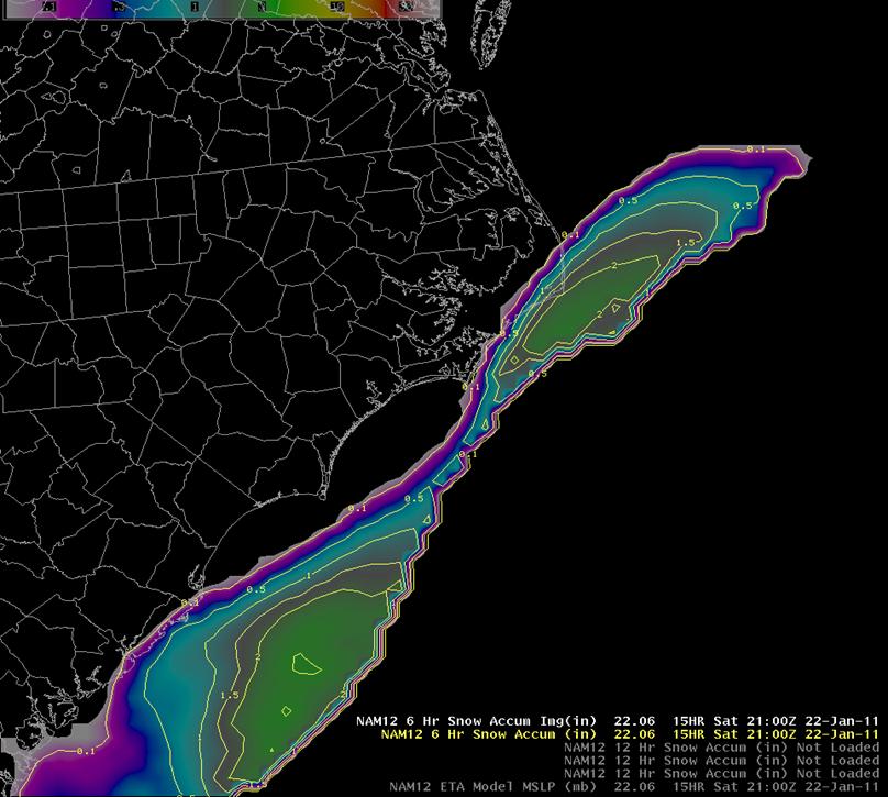
Figure 13. The 06Z (1 am) Saturday NAM12 model verifying at 21Z (5 pm) Saturday afternoon shows almost no snow over Carteret, Craven or Pamlico counties, but did show 1 to 2 inches near Cape Hatteras.
The GFS snowfall amounts verified better, better showing the axis of higher snowfall amounts near the coast. The ECMWF was similar to the GFS with low strength and placement, and showing at least light snow accumulation along the coastal counties. Additionally, theHydrometeorological Prediction Center (HPC) predicted a swath of 1 to 2 inches of snow right along the immediate coast with no snowfall inland. These model differences led to uncertainties in forecasting the amount and placement of heavier snowfall.
Advisories/Warnings
The initial Winter Weather Advisory was issued at 343 PM Friday for Carteret County and the Outer Banks counties of Hyde and Dare, for 1 to locally 2 inches of snow. The advisory was from 1 PM until 10 PM Saturday. At 3:37 AM Saturday, with precipitation already developing off the South Carolina coast, the beginning of the Advisory was moved up to 10 AM, and Craven and Onslow counties were added. Snow was observed over Carteret County beginning just before 9 AM Saturday morning. At 12:17 PM, Mainland Hyde, Pamlico and Beaufort Counties were added to the Winter Weather Advisory. The Advisory was upgraded to a Winter Storm Warning for Carteret, Craven, Pamlico and Mainland Hyde counties at 1:43 pm as bands of heavy snow continue to move across the coastal and adjacent counties. As the heavier snow moved toward the Outer Banks, the advisory for Outer Banks Hyde and Dare counties was upgraded to a Winter Storm Warning through 10 PM. As the snowfall ended over Onslow County, the advisory was cancelled there at 5:46 PM. Shortly thereafter, at 6:03 PM, Warnings were cancelled for Craven, Pamlico and Beaufort counties. As the snow ended from south to north, the Winter Storm Warning for Mainland Hyde and Carteret counties was cancelled at 7:29 PM, and then was cancelled for Outer Banks Hyde county at 9:18 PM, before expiring at 10 PM for Outer Banks Dare county. Numerous Local Storm Reports (LSR’s) and Public Information Statements (PNS’s) were issued throughout the course of the day to provide the latest snowfall amount information.
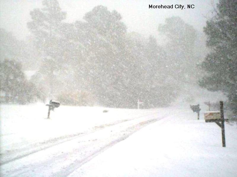
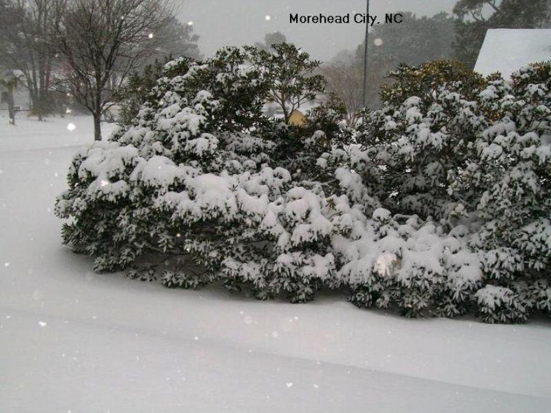
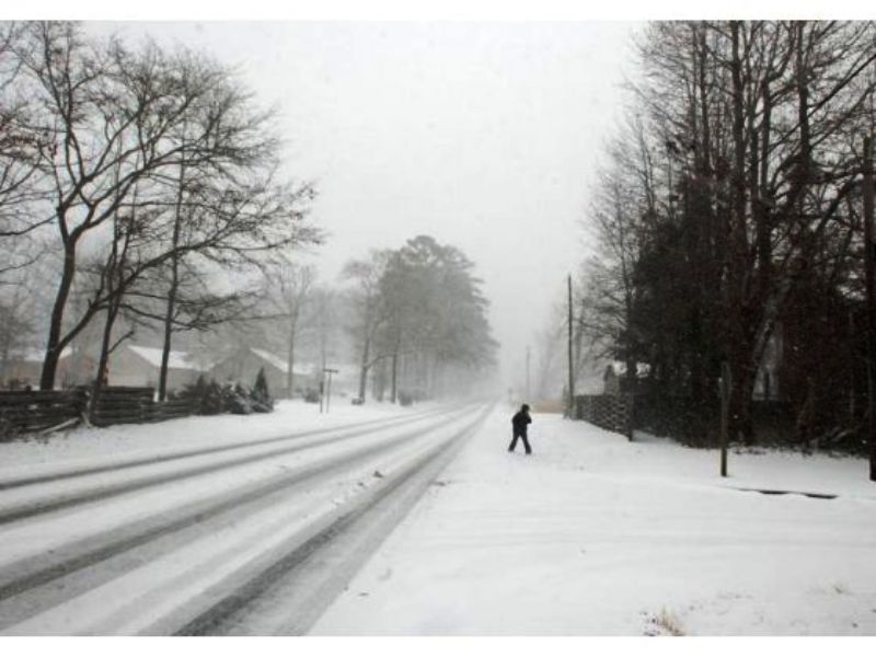
Snowfall Pictures from CARTERET and CRAVEN Counties
Photos courtesy of: Chris Collins, Cheri Collins, Drew Wilson
Case Study Team:
Chris Collins
Lara Pagano


 Map View
 Weather Hazard Briefing (when applicable)
 Forecaster Discussion
 Marine
 Text Products
.png) Skywarn
Skywarn Submit Storm Reports
 Coastal Flood
.png) Surf Forecast/Rip Currents
Surf Forecast/Rip Currents