HURRICANE ISABEL, SEPTEMBER 18, 2003


|
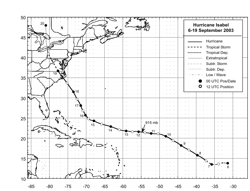
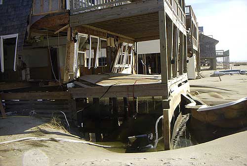
SUMMARY Isabel became the ninth named storm of the 2003 Atlantic hurricane season on September 6, 2003. Isabel began as a strong tropical wave off the West African Coast about three days earlier, and was upgraded to a hurricane by September 7. Isabel intensified rapidly on the 8th, going through Categories 2 and 3 of the Saffir-Simpson Hurricane Scale and reaching Category 4 intensity that day. Isabel remained a strong Category 4 hurricane until reaching the rare Category 5 status by September 11. Isabel remained at or near Category 5 intensity until September 14, when it weakened to a Category 4 storm. Weakening continued through Tuesday, decreasing to a Category 2 by late morning Tuesday, September 16. Isabel made landfall near Drum Inlet around 1 p.m. on Thursday, September 18. Isabel moved northwest then accelerated to northeast so by midday Friday, the center of the storm was losing tropical characteristics and was near Cleveland, Ohio. Most of the effects of Isabel were experienced between Thursday morning and Friday evening. Isabel produced storm surges of 6 to 8 feet above normal tide levels near the point of landfall along North Carolina coast. Farther north, storm surge values ranged from 4 to 6 feet along the Virginia coast, 2 to 4 feet along the Maryland, Delaware and New Jersey shorelines, and 1 to 2 feet along the coast of Long Island and in the Long Island sound. In the North Carolina estuaries, storm surge values were generally 4 to 6 feet above normal tide levels over the eastern portions of the Pamlico Sound and most of the Albemarle Sound. Values of 6-10 ft above normal tide levels were observed in the western end of the Pamlico Sound with a maximum value of 10.5 feet reported on the Neuse River in Craven County. Hurricane Isabel left her permanent calling card with the generation of a new inlet located near Cape Hatteras Village, which has since been refilled. Isabel is directly responsible for 17 deaths, mainly through drowning, or persons or automobiles hit by falling trees or limbs. The estimated total economic loss from Isabel is $5 billion. In eastern North Carolina, Isabel produced moderate to heavy damage, totaling $450 million (2003 USD, $562 million 2013 USD). Damage was heaviest in Dare County, where storm surge flooding and strong winds damaged thousands of houses. Strong winds downed hundreds of trees of across the state of North Carolina, leaving up to 700,000 residents without power. Most areas with power outages had power restored within a few days. The hurricane directly killed one person and indirectly killed two in the state.
ISABEL TRACK
ISABEL IMPACT GRAPHICS (CLICK ON GRAPHIC TO ENLARGE)
ISABEL RAINFALL AMOUNTS
Rainfall Totals associated with Hurricane Isabel
LONG TERM IMPACTS FROM HURRICANE ISABEL A federal disaster was declared for 36 North Carolina counties. The disaster declaration allocated the use of federal funds for rebuilding and providing aid in the aftermath of Isabel and totaled about $516 million (2003 USD, $644 million 2013 USD), primarily in North Carolina and Virginia. In North Carolina, hundreds of residents were stranded in Hatteras following the formation of the new "Isabel Inlet". People who were not residents were not allowed to be on the Outer Banks for two weeks after the hurricane due to damaged road conditions. Initially, long term solutions to the Isabel Inlet such as building a bridge or a ferry system were considered, though they were ultimately canceled in favor of pumping sand and filling the inlet. Geologists were opposed to the solution, stating the evolution of the Outer Banks is dependent on inlets from hurricanes. Dredging operations began about a month after the hurricane struck. The United States Geological Survey used sand from the ferry channel to the southwest of Hatteras Island, a choice made to minimize the impact to submerged aquatic vegetation and due to the channel being filled somewhat during the hurricane. On November 22, 2003, about two months after the hurricane struck, North Carolina Highway 12 and Hatteras Island were reopened to public access. On the same day, the ferry between Hatteras and Ocracoke was reopened.
IMAGES OF ISABEL (CLICK TO ENLARGE)
BEFORE AND AFTER IMAGES OF THE OUTER BANKS (CLICK TO ENLARGE)
Personal Accounts from Hurricane Isabel (Courtesy Island Free Press)
Trip to Ocracoke cancelled because of Isabel
By JACKIE SANCHO We – the Yochum family -- were staying in Nags Head the year Isabel hit the OBX. My sister-in-law and I had decided to take a ride to Hatteras in my father’s conversion van and take the ferry over to Ocracoke. We had been watching the Weather Channel continuously so we knew Isabel was headed for us, but thought we had a few days before it hit to enjoy ourselves. As we arrived at the ferry docks, we heard a rumor that Ocracoke was evacuating. We asked the ferry worker at the dock whether we could get over to the island? His reply made our mouths hang open! He said in a slow southern drawl," Well, we can get you ladies over there and back but I can't guarantee your van will come back with you. You may have to leave it on Ocracoke!" All we could think of was the look on my dad's face when we told him we had to leave his van over on Ocracoke! We got back in the van and left. On our way north, we stopped at many of the shops in Hatteras and bought souvenirs as people were packing and boarding up. They seemed worried and not sure how things would look when they came back. We left Nags Head the next day and really should have left earlier. We sat in traffic for hours watching people run into the bushes to use the bathroom because everything was boarded up. All the way home all we could think of was the people on Hatteras Island and we hoped they got out in time.
One couple’s first week-long visit to Ocracoke cut short by Isabel
By CHARLIE MARKLE We were really looking forward to spending a whole week on Ocracoke since it was apparently our favorite place to visit on the Outer Banks, although we were slow to realize it. Even though it was only 10 years ago, the storm tracking technology available to the average person was not as accessible as it is today. We went there naively with the hope that it would not impact our stay. Were we ever wrong! We were on the beach Monday morning when the park ranger came by and announced that all non-residents needed to leave immediately. So we packed up our things and headed back to cottage to get ready to leave. Meanwhile, the rental agency called us several times and told us we had to be out right away and they were going to cut off our electricity. We were only back at the cottage for an hour or so, and we had to repack everything, so it was going to take awhile. After we were done packing, we got to thinking why wait in line at the ferry when the storm was still four days away? We stopped at Howard’s Pub on our way out, since it was always a “must do” when on Ocracoke. That is our memory of Isabel and our first “week” stay on Ocracoke. But not to be dismayed by that event, we have stayed on Ocracoke just about every year since then for a week in September. It always seems like something is missing if I don’t get my Ocracoke fix every year. We definitely keep a close look at the National Hurricane Center and Weather Underground sites when vacation time rolls around. For more information, follow these links:
http://www.nhc.noaa.gov/
For Additional Information on Hurricane Isabel, visit the Island Free Press website. |


.png) Surf Forecast/Rip Currents
Surf Forecast/Rip Currents Tropical Weather
 Map View
 Weather Hazard Briefing (when applicable)
 Forecaster Discussion
 Marine
 Text Products
.png) Skywarn
Skywarn Submit Storm Reports