Hurricane Ian (2022) was a unique and challenging storm that brought widespread impacts to eastern North Carolina. Following a relatively slow beginning to the Atlantic Hurricane Season, the tropics began to get more active in mid-September. What would later become Hurricane Ian initially formed as a tropical depression over the central Caribbean on the morning of Friday September 23, strengthening into a Tropical Storm and getting the name Ian later that evening. Ian then tracked south of Jamaica and strengthened into a Hurricane on the morning of Monday September 26th before passing over western Cuba as a Major Hurricane on Tuesday September 27th. Major Hurricane Ian then tracked north-northeastward over the next 36 hours before making landfall on the southwest coast of the Florida Peninsula, bringing catastrophic storm surge and wind impacts to heavily populated areas around Fort Myers, FL.
Ian weakened to a tropical storm br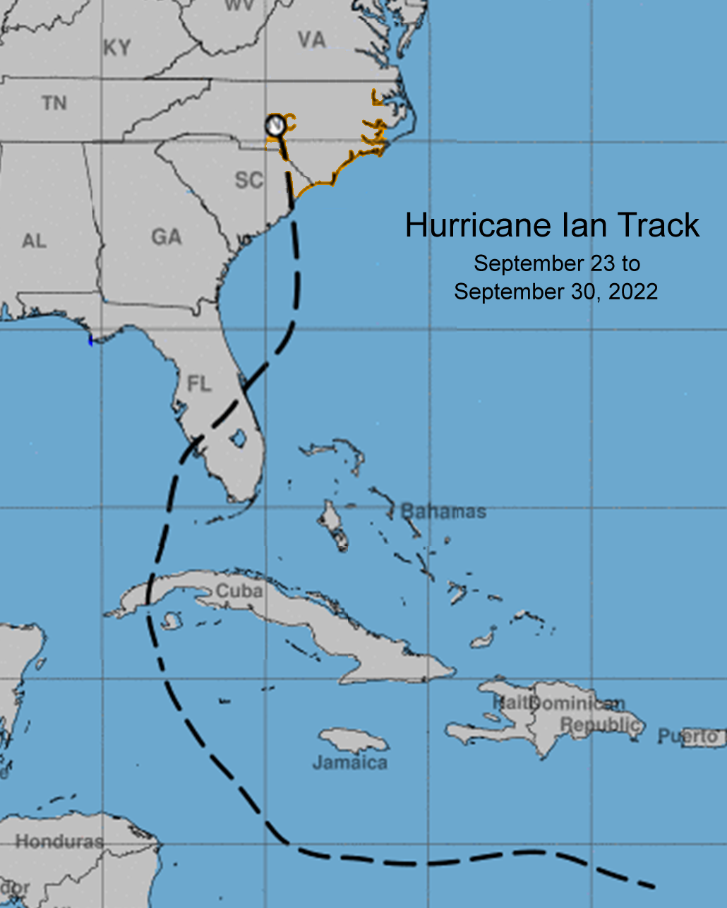 iefly as it moved off the east coast of Florida near Cape Canaveral on the morning of Thursday September 29th, but quickly restrengthened to a hurricane later that afternoon as it continued to move northward toward an eventual landfall as a Category 1 hurricane along the central South Carolina coast. It was during this emergence off the Southeast coast that significant local impacts to eastern NC began as Hurricane Ian interacted with a stalled front off the coast and high pressure inland to bring a prolonged period of strong NE winds beginning later in the day on Wednesday September 28th and continuing through Friday September 30th. These strong northeast winds created elevated tide levels and strong northeast swell, which combined with the developing strong southerly swell from the winds in the core of Ian, brought extensive overwash along Hatteras Island, Ocracoke Island, and Core Banks. Tide gage observations and spotter reports indicate that around 2 to 4 feet of inundation about ground level were observed across much of the coast south of Cape Hatteras, southern portions of the Pamlico Sound, and tidal portions of the Neuse, Bay, and Pamlico Rivers. Numerous roads were flooded by storm surge and at least partially impassible, including NC 12 on Ocracoke and Hatteras Island, Hwy 70 near the North River Bridge in Carteret County, and several roads Down East Carteret County.
The maximum observed water level of 6.37 ft Mean Lower Low Water at the Beaufort Tide Gage corresponds to approximately 2-3 ft of above ground storm surge inundation and is the 8th highest water level on record for the gage, with records dating back to 1964. Additionally, several tide gauges which are only 1-3 years old set new highest observed benchmarks, including the Trent River at New Bern (since June 2021), Bogue Sound at Emerald Isle (since March 2019), and the Intercoastal Waterway at North Topsail Island (since October 2021). The tide gage at Cedar Island, which has been in place May 2013, recorded its 3rd highest water level on record, though this gauge has experienced extended outages in the past several years. Finally, the Pamlico River at Washington gage experienced the highest water level since Hurricane Florence in 2018.
Additionally, localized wind impacts were observed with isolated tree damage and power outages across eastern NC. Areas of heavy rainfall resulting in storm total rainfall amounts as high as 3-6 inches in places, with some localized fresh water flooding being observed.
Rain Reports
Rainfall Totals
.png)
Precipitation Reports from Hurricane Isaias
Public Information Statement
National Weather Service Newport/Morehead City NC
1022 AM EDT Sat Oct 1 2022

...48 HOUR PRECIPITATION REPORTS FROM IAN...

Location                     Amount    Time/Date       Provider

...North Carolina...

...Beaufort County...
Washington 10.5 ESE          5.85 in   0700 AM 10/01   COCORAHS
Washington 3.1 ESE           5.44 in   0700 AM 10/01   COCORAHS
Bunyan RAWS                  5.38 in   1013 AM 10/01   RAWS
Pantego 0.4 WSW              4.71 in   0615 AM 10/01   COCORAHS
Chocowinity 0.2 W            3.87 in   0800 AM 10/01   COCORAHS

...Carteret County...
Williston 0.9 SW             8.10 in   0700 AM 10/01   COCORAHS
Beaufort 5.1 NNE             6.64 in   0700 AM 10/01   COCORAHS
Cape Carteret 4.2 NW         6.64 in   0700 AM 10/01   COCORAHS
Beaufort 5.3 N               6.62 in   0800 AM 10/01   COCORAHS
Beaufort 3.8 N               6.61 in   0700 AM 10/01   COCORAHS
Beaufort 6.3 NNW             6.27 in   0800 AM 10/01   COCORAHS
Beaufort 15.1 N              6.11 in   0700 AM 10/01   COCORAHS
Beaufort 3.4 NNW             5.89 in   0800 AM 10/01   COCORAHS
Beaufort 3.7 NNW             5.58 in   0800 AM 10/01   COCORAHS
Beaufort 0.5 W               4.91 in   0800 AM 10/01   COCORAHS
Cape Carteret 1.5 NE         4.73 in   0800 AM 10/01   COCORAHS
Beaufort 1.5 NNW             4.60 in   0700 AM 10/01   COCORAHS
Ocean 0.5 S                  4.52 in   0800 AM 10/01   COCORAHS
Swansboro 3.7 NNE            4.35 in   0732 AM 10/01   COCORAHS
Cape Carteret 0.8 NE         4.33 in   0750 AM 10/01   COCORAHS
Newport (WFO MHX)            4.20 in   1200 AM 10/01   COOP
Newport 1.7 SSE              4.10 in   0800 AM 10/01   COCORAHS
Peletier 1.6 W               4.10 in   0800 AM 10/01   COCORAHS
Cape Carteret 1.0 NNW        4.07 in   0700 AM 10/01   COCORAHS
Cedar Point 0.4 WSW          4.06 in   0800 AM 10/01   COCORAHS
Cedar Point 0.9 WSW          4.05 in   0529 AM 10/01   COCORAHS
Newport 0.2 SW               4.01 in   0700 AM 10/01   COCORAHS
Pine Knoll Shores 1.4 E      3.98 in   0700 AM 10/01   COCORAHS
Beaufort (MRH ASOS)          3.87 in   0958 AM 10/01   ASOS
Cedar Island RAWS            3.85 in   0925 AM 10/01   RAWS
Morehead City 5.1 WNW        3.79 in   0700 AM 10/01   COCORAHS
Emerald Isle 2.1 E           3.75 in   0700 AM 10/01   COCORAHS
Morehead City 0.1 E          3.75 in   0800 AM 10/01   COCORAHS
Stella 2.5 SE                3.74 in   0700 AM 10/01   COCORAHS
Morehead City 0.6 NW         3.65 in   0700 AM 10/01   COCORAHS
Indian Beach 0.0 W           3.39 in   0700 AM 10/01   COCORAHS
Morehead City 2.9 WNW        3.37 in   0708 AM 10/01   COCORAHS
Morehead City 5.7 W          3.26 in   0700 AM 10/01   COCORAHS
Croatan RAWS                 2.94 in   0948 AM 10/01   RAWS
Atlantic Beach 0.6 W         2.47 in   0731 AM 10/01   COCORAHS

...Craven County...
Perrytown (COOP)             3.95 in   0730 AM 10/01   COOP
Trent Woods 1.3 SSE          3.95 in   0700 AM 10/01   COCORAHS
New Bern 8.8 W               3.88 in   0700 AM 10/01   COCORAHS
Havelock 1.9 SSE             3.83 in   0631 AM 10/01   COCORAHS
New Bern 7.3 ESE             3.77 in   0700 AM 10/01   COCORAHS
New Bern 5.2 SE              3.70 in   0704 AM 10/01   COCORAHS
New Bern 5.3 SW              3.69 in   0700 AM 10/01   COCORAHS
New Bern 7.7 ESE             3.60 in   0700 AM 10/01   COCORAHS
New Bern 2.6 SW              3.58 in   0700 AM 10/01   COCORAHS
River Bend 0.8 ENE           3.55 in   0700 AM 10/01   COCORAHS
New Bern 3.8 S               3.48 in   0800 AM 10/01   COCORAHS
New Bern 1.5 NW              3.46 in   0916 AM 10/01   COCORAHS
Trent Woods 1.0 NNE          3.46 in   0714 AM 10/01   COCORAHS
Trent Woods 1.2 ENE          3.36 in   0600 AM 10/01   COCORAHS
New Bern 1.4 WSW             3.33 in   0800 AM 10/01   COCORAHS
New Bern 1.3 NNE             3.28 in   0700 AM 10/01   COCORAHS
Cherry Point (NKT ASOS)      2.55 in   0956 AM 10/01   AWOS
New Bern RAWS                2.08 in   0917 AM 10/01   RAWS

...Dare County...
Southern Shores 0.5 NNE      5.53 in   0700 AM 10/01   COCORAHS
Dbr Soil Monitor             5.51 in   0954 AM 10/01   RAWS
Dare Co Gnry Ran (2DP AWOS)  5.04 in   0955 AM 10/01   AWOS
Dare Bomb Range RAWS         4.54 in   0928 AM 10/01   RAWS
Frisco (HSE ASOS)            4.51 in   0951 AM 10/01   ASOS
Duck                         3.86 in   0700 AM 10/01   COCORAHS
Manteo 2.8 NW                3.80 in   0800 AM 10/01   COCORAHS
Buxton RAWS                  3.34 in   0930 AM 10/01   RAWS
Rodanthe 1.0 SSE             3.28 in   0700 AM 10/01   COCORAHS
Kill Devil Hills (FFA AWOS)  2.70 in   1015 AM 10/01   AWOS
Manteo (MQI AWOS)            2.59 in   0955 AM 10/01   AWOS

...Duplin County...
Albertson 1.2 WNW            3.79 in   0600 AM 10/01   COCORAHS
Mount Olive 6.0 SE           3.19 in   0800 AM 10/01   COCORAHS
Wallace 14.8 E               2.97 in   0700 AM 10/01   COCORAHS
Rose Hill 0.1 NNW            2.67 in   0700 AM 10/01   COCORAHS
Mount Olive 2.4 SW           2.55 in   0700 AM 10/01   COCORAHS
Summerlins Crossroads 3 SE   2.53 in   0800 AM 10/01   COOP
1.5 SE Wallace               2.40 in   0600 AM 10/01   UCOOP

...Greene County...
Snow Hill                    2.84 in   0700 AM 10/01   COOP
Snow Hill 3.1 NNE            2.77 in   0800 AM 10/01   COCORAHS
Ayden 6.5 WNW                2.70 in   0700 AM 10/01   COCORAHS
Hookerton 0.5 ESE            2.43 in   0700 AM 10/01   COCORAHS

...Hyde County...
Engelhard 0.8 NW             4.45 in   0700 AM 10/01   COCORAHS
Ocracoke 0.2 ESE             3.46 in   0800 AM 10/01   COCORAHS
Fairfield RAWS               3.19 in   0917 AM 10/01   RAWS

...Lenoir County...
Pink Hill 2.5 NE             3.67 in   0700 AM 10/01   COCORAHS
Kinston 7.0 SW               3.40 in   0700 AM 10/01   COCORAHS
Kinston 4.4 WNW              2.87 in   0700 AM 10/01   COCORAHS
La Grange 0.9 SW             2.83 in   0700 AM 10/01   COCORAHS
Kinston 1.2 NW               2.77 in   0700 AM 10/01   COCORAHS
Kinston 5.1 WNW              2.64 in   0700 AM 10/01   COCORAHS

...Martin County...
Williamston 8.9 SSE          4.86 in   0837 AM 10/01   COCORAHS
Robersonville 0.0 NNW        4.60 in   0700 AM 10/01   COCORAHS
Jamesville 6.1 SW            4.20 in   0700 AM 10/01   COCORAHS

...Onslow County...
Jacksonville 4.5 NW          5.00 in   0700 AM 10/01   COCORAHS
Jacksonville 4.5 NW          4.12 in   0700 AM 10/01   COCORAHS
Jacksonville (COOP)          4.03 in   0645 AM 10/01   COOP
Jacksonville 6.8 NW          3.97 in   0700 AM 10/01   COCORAHS
1 NW Pumpkin Center          3.88 in   0900 AM 10/01   COCORAHS
Swansboro 3.3 NW             3.76 in   0700 AM 10/01   COCORAHS
Swansboro 2.8 WSW            3.17 in   0700 AM 10/01   COCORAHS
Jacksonville 1.2 NE          3.12 in   0700 AM 10/01   COCORAHS
Hoffman RAWS                 3.11 in   1010 AM 10/01   RAWS
Holly Ridge 9.0 ENE          3.06 in   0700 AM 10/01   COCORAHS
Richlands 2.8 NW             3.06 in   0900 AM 10/01   COCORAHS
2 WNW New River Station      2.95 in   0700 AM 10/01   COCORAHS
Sneads Ferry 1.2 SSW         2.88 in   0700 AM 10/01   COCORAHS
Sandy Run RAWS               2.83 in   0919 AM 10/01   RAWS
Richlands (OAJ AWOS)         2.78 in   0956 AM 10/01   AWOS
Swansboro 1.9 NNW            2.75 in   0845 AM 10/01   COCORAHS
Jacksonville (NCA ASOS)      2.39 in   0956 AM 10/01   AWOS

...Pamlico County...
Oriental 2.1 WSW             6.16 in   0900 AM 10/01   COCORAHS
Bayboro 3 SW                 5.83 in   0700 AM 10/01   COOP
Merritt 1.5 WSW              5.82 in   0600 AM 10/01   COCORAHS
Oriental 4.3 NNW             5.51 in   0700 AM 10/01   COCORAHS
Lowland 0.2 SE               5.36 in   0700 AM 10/01   COCORAHS
Grantsboro 4.6 SSW           4.30 in   0819 AM 10/01   COCORAHS

...Pitt County...
Greenville 5.0 SE            3.87 in   0700 AM 10/01   COCORAHS
Greenville 7.1 SSE           3.69 in   0700 AM 10/01   COCORAHS
Greenville 7.3 SSE           3.66 in   0935 AM 10/01   COCORAHS
Greenville 4.7 WNW           3.44 in   0845 AM 10/01   COCORAHS
Winterville 1.0 ENE          3.44 in   0700 AM 10/01   COCORAHS
Greenville (COOP)            3.40 in   1200 AM 10/01   COOP
Greenville 5.7 NW            3.33 in   0700 AM 10/01   COCORAHS
Winterville 3.5 W            3.01 in   0700 AM 10/01   COCORAHS
Fountain 0.1 NE              2.73 in   0700 AM 10/01   COCORAHS
Winterville 2.6 ENE          2.11 in   0630 AM 10/01   COCORAHS
Greenville 1.4 SE            2.10 in   0700 AM 10/01   COCORAHS
Winterville 2.8 WNW          2.07 in   0900 AM 10/01   COCORAHS

...Tyrrell County...
Columbia 0.8 NNE             7.21 in   0700 AM 10/01   COCORAHS
Gum Neck (COOP)              4.03 in   0640 AM 10/01   COOP

...Washington County...
Roper 2.4 NE                 5.77 in   0700 AM 10/01   COCORAHS
Pocosin Lakes RAWS           3.53 in   0917 AM 10/01   RAWS

...Maritime Stations...
Washington 1.0 SSW           5.27 in   0800 AM 10/01   COCORAHS
Wind Reports
Wind Gusts
Wind Reports from Hurricane Isaias
Public Information Statement
National Weather Service Newport/Morehead City NC
323 AM EDT Sat Oct 1 2022

...UPDATED HIGHEST WIND REPORTS OVER THE LAST 24 HOUR FROM IAN...

Location                     Speed     Time/Date       Provider

...North Carolina...

...Beaufort County...
Belhaven 1.8 SW              43 MPH    0527 PM 09/30   CWOP

...Carteret County...
Piney Island (NBT AWOS)      53 MPH    0541 AM 09/30   AWOS
Fort Macon (WxFlow)          50 MPH    0718 AM 09/30   WXFLOW
Beaufort                     49 MPH    0215 PM 09/30   CWOP
Bogue Field (NJM ASOS)       48 MPH    0710 AM 09/30   AWOS
Beaufort (Duke Marine Lab)   48 MPH    0248 PM 09/30   NOS-NWLON
Cape Lookout                 47 MPH    0300 PM 09/30   NDBC
Emerald Isle                 43 MPH    0540 PM 09/30   DAVIS
Newport 7.5 E                42 MPH    0400 PM 09/30   CWOP
Atlantic Beach 0.4 E         41 MPH    0615 AM 09/30   CWOP
Beaufort (MRH ASOS)          41 MPH    0329 PM 09/30   ASOS
Morehead City 4.7 W          40 MPH    0330 PM 09/30   CWOP

...Craven County...
Cherry Point (NKT ASOS)      49 MPH    0426 PM 09/30   AWOS
New Bern (EWN ASOS)          41 MPH    0127 PM 09/30   ASOS

...Dare County...
Oregon Inlet CG (WxFlow)     57 MPH    0703 AM 09/30   WXFLOW
Avon (WxFlow)                53 MPH    0605 AM 09/30   WXFLOW
Buxton (WxFlow)              48 MPH    0812 AM 09/30   WXFLOW
Nags Head                    47 MPH    0701 AM 09/30   CWOP
Real Slick (WxFlow)          46 MPH    0951 AM 09/30   WXFLOW
Oregon Inlet (WxFlow)        46 MPH    1059 AM 09/30   WXFLOW
Frisco (HSE ASOS)            46 MPH    1255 PM 09/30   ASOS
KHK Resort (WxFlow)          45 MPH    0637 AM 09/30   WXFLOW
Rodanthe 0.6 N               45 MPH    0855 AM 09/30   CWOP
Ecu Coastal Studies Institut 42 MPH    0930 AM 09/30   MESOWEST
Hatteras High (WxFlow)       41 MPH    0813 AM 09/30   WXFLOW
Oregon Inlet Marina          41 MPH    1100 AM 09/30   NOS-NWLON
Manteo (MQI AWOS)            40 MPH    1235 PM 09/30   AWOS

...Duplin County...
Kenansville (DPL AWOS)       40 MPH    0315 PM 09/30   AWOS

...Onslow County...
Jacksonville (NCA ASOS)      52 MPH    0435 PM 09/30   AWOS

...Washington County...
Roper 9.8 ENE                43 MPH    0445 PM 09/30   CWOP

...Maritime Stations...
Jennettes Pier (WxFlow)      63 MPH    0838 AM 09/30   WXFLOW
Alligator River Br (WxFlow)  61 MPH    1243 PM 09/30   WXFLOW
Duck Pier                    58 MPH    0218 PM 09/30   NOS-NWLON
Ocracoke (WxFlow)            56 MPH    0649 AM 09/30   WXFLOW
Diamond Buoy (41025)         54 MPH    1010 AM 09/30   NDBC
Pamlico Sound (WxFlow)       53 MPH    0856 AM 09/30   WXFLOW
Avon Sound (WxFlow)          52 MPH    0543 AM 09/30   WXFLOW
Frisco Woods (WxFlow)        51 MPH    0828 AM 09/30   WXFLOW
Roanoke Sound Channel (WxFlo 47 MPH    1130 AM 09/30   WXFLOW
Croatan Sound                44 MPH    1145 AM 09/30   WXFLOW
Manteo                       40 MPH    1035 AM 09/30   DAVIS
Waterspouts
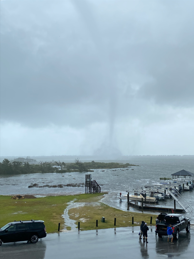 |
At approximately 2 PM on Tuesday September 30, a waterspout occurred on the western Bogue Sound. This photograph was taken from the Bogue Watch neighborhood. There were no indications that this waterspout impacted land.
|
Satellite
Pictures/Social Media
We were out and about this morning checking on #NewBern's streets, the Neuse and Trent Rivers and their tributaries. Here's the video of Brices Creek Boat Ramp/Dock across from Merchant's Grocery taken at 9:30 a.m. today, Sept. 30, 2022. More footage to come ... pic.twitter.com/xEyuCcJ9WB
— New Bern Now (@NewBernNow) September 30, 2022
Water is already rushing into Union Park in New Bern. It’s only going to get worse so stay off the roads! @WITN pic.twitter.com/bD7TWfCIWh
— Justin Odell Lundy (@_JustinLundyTV) September 30, 2022
A Family Member sent me these following pics of #Beaufort #Waterfront #NC #NorthCarolina earlier today. #1 of 4 pic.twitter.com/DuYE4yPOk5
— Angel (@MsCeeAngel) September 30, 2022
Strong winds just tore the metal siding off of this gas station in Kinston, NC right after I pulled up. Almost struck a passing car. pic.twitter.com/mbFYjuuxdc
— Zay ⛈ (@stormchaserzay) September 30, 2022


.png) Surf Forecast/Rip Currents
Surf Forecast/Rip Currents Tropical Weather
 Map View
 Weather Hazard Briefing (when applicable)
 Forecaster Discussion
 Marine
 Text Products
.png) Skywarn
Skywarn Submit Storm Reports