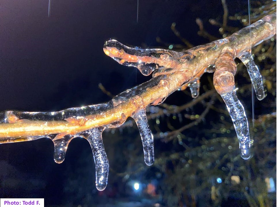
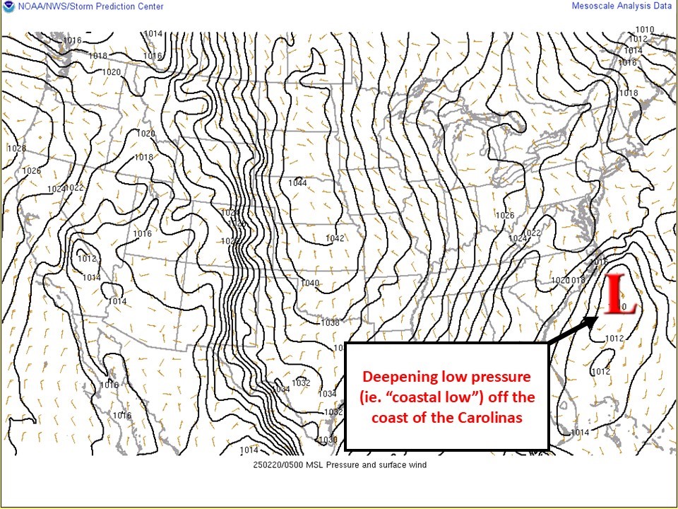
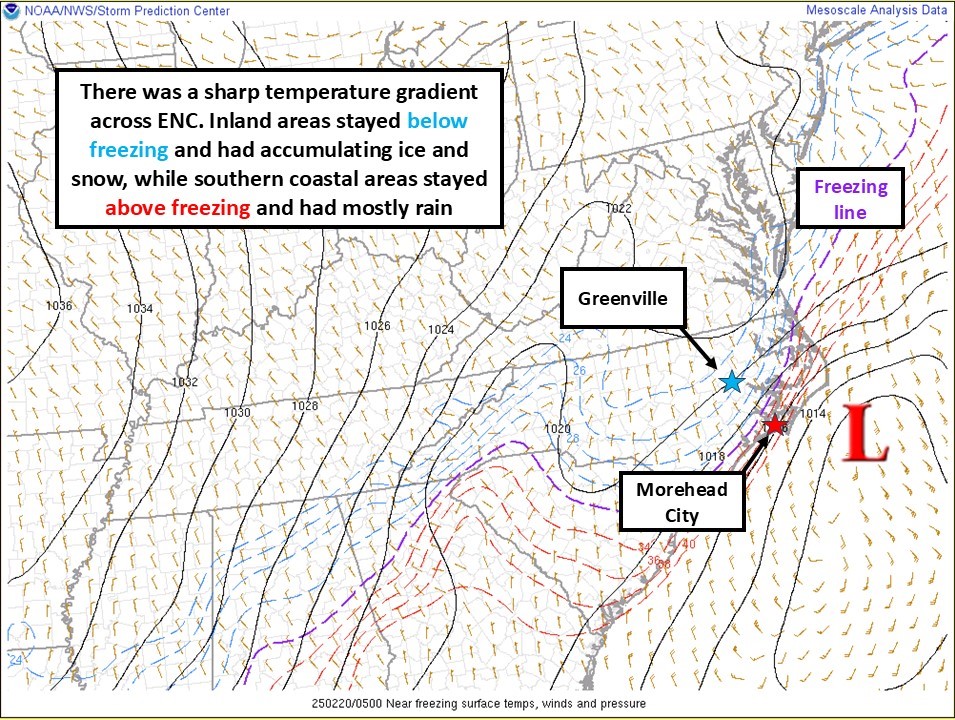
 An area of low pressure, known as a "coastal low", developed along the U.S. Gulf Coast, traveled northeast up along the Southeast U.S. coastline, then off the coast of the Carolinas. An area of widespread precipitation developed along the track of the low. Where temperatures were cold enough, there was a mix of sleet, freezing rain, and snow. For areas from the Crystal Coast through the southern Outer Banks, the precipitation type was mostly rain. This event produced a swath of accumulating sleet and snow from central North Carolina through southeast Virginia. South of the snow and sleet, there was a swath of accumulating ice, with a zone of 0.10" - 0.30" of ice accretion. The combination of ice and wind led to tree and power line damage across parts of ENC, with numerous power outages reported. The wintry precipitation was followed up by very cold temperatures, with lows bottoming out in the teens for many areas away from the coast.
Snowfall Reports
Public Information Statement
National Weather Service Newport/Morehead City NC
821 AM EST Fri Feb 21 2025

...Winter Weather Reports February 19th-20th, 2025...

Below are various reports of winter weather the across Eastern North
Carolina. With a variety of winter weather precipitation types,
often varying minute by minute, the categories are broken up by
predominant precipitation type. For the snow and sleet reports,
the majority of these were a combination of both.

Thank you to our spotters, local emergency management, coop weather
observers, utility companies and the general public for providing us
with these reports. If you would like to become an official weather
spotter visit our website at www.weather.gov/mhx/skywarn


...SNOWFALL REPORTS...

Location                     Amount    Time/Date       Provider

...North Carolina...

...Beaufort County...
3 W Long Acre VFD            1.0 in    1034 AM 02/20   Emergency Mngr


...Carteret County...
Newport 0.2 SW                T in     0700 AM 02/20   COCORAHS
Cape Carteret 1.5 NE          T in     0700 AM 02/20   COCORAHS
Cedar Point                   T in     0700 AM 02/20   COCORAHS
Cape Carteret 1.5 NE          T in     0700 AM 02/20   COOP
Newport 2.5 W                 T in     0800 AM 02/20   COCORAHS

...Dare County...
Southern Shores              4.0 in    0600 PM 02/19   Public
Kitty Hawk                   4.0 in    0633 PM 02/19   Public
Kill Devil Hills             4.0 in    1053 AM 02/20   Public
Wright Brothers National Mon 3.0 in    0520 PM 02/19   Public
Kitty Hawk                   3.0 in    0625 PM 02/19   Public
Duck 0.7 SSE                 2.5 in    0700 AM 02/21   COCORAHS
Kill Devil Hills             2.0 in    1047 AM 02/20   Public
Manteo 2.8 NW                1.8 in    0800 AM 02/20   COCORAHS

...Martin County...
Robersonville                4.5 in    1027 AM 02/20   Public
Williamston                  3.0 in    1013 AM 02/20   Emergency Mngr
Jamesville                   2.0 in    0550 PM 02/19   Public


...Pitt County...
Greenville (COOP)            1.3 in    1158 PM 02/19   COOP
3 WSW Fountain               1.2 in    1100 PM 02/19   Public
3 NNE Bruce                  1.0 in    1053 AM 02/20   Public


...Tyrrell County...
Columbia                     2.5 in    0916 AM 02/20   Emergency Mngr
Columbia 0.8 NNE             2.0 in    0700 AM 02/20   COCORAHS


...Washington County...
Creswell                     3.0 in    1255 PM 02/20   Public
Plymouth                     2.5 in    0800 AM 02/20   Emergency Mngr


...FREEZING RAIN REPORTS...

Location                     Amount    Time/Date       Provider

...North Carolina...

...Beaufort County...
Belhaven                     0.28 in   1001 AM 02/20   Trained Spotter
1 NW Washington Park         0.28 in   1047 AM 02/20   Trained Spotter
2 ENE Winsteadville          0.25 in   0830 PM 02/19   Trained Spotter
1 NE Pinetown                0.25 in   0900 AM 02/20   Utility Company
Pantego                      0.25 in   0914 AM 02/20   Broadcast Media
Pamlico Beach                0.25 in   1003 AM 02/20   Public
1 SSW Terra Ceia             0.25 in   1048 AM 02/20   Emergency Mngr


...Carteret County...
1 W Bogue                     T   in   0700 AM 02/20   NWS Employee
1 N Cedar Point               T   in   0700 AM 02/20   NWS Employee

...Craven County...
Cherry Point (NKT ASOS)      0.30 in   1042 AM 02/20   AWOS
Trent Woods                  0.25 in   0714 AM 02/20   Trained Spotter
1 SE Vanceboro               0.25 in   0900 AM 02/20   Utility Company
Vanceboro                    0.25 in   1037 AM 02/20   Public
3 ENE James City             0.20 in   0821 AM 02/20   Public
3 SSE Askin                  0.20 in   0825 AM 02/20   Public
New Bern                     0.20 in   0952 AM 02/20   Public

...Duplin County...
1 NW Albertson               0.25 in   0900 AM 02/20   Utility Company
1 WSW Cypress Creek          0.25 in   0955 AM 02/20   Trained Spotter
1 E Kenansville              0.20 in   0830 PM 02/19   Trained Spotter
Beulaville                   0.13 in   1048 AM 02/20   Public

...Hyde County...
Sladesville                   T   in   0158 PM 02/19   Public

...Jones County...
4 E Trenton                  0.25 in   1156 PM 02/19   Utility Company

...Lenoir County...
La Grange                    0.30 in   1128 PM 02/19   Trained Spotter
1 N Deep Run                 0.25 in   0900 AM 02/20   Public

...Martin County...
3 E Beargrass                0.25 in   0857 PM 02/19   Emergency Mngr
Williamston                  0.25 in   0930 PM 02/19   Emergency Mngr

...Onslow County...
4 NNW Albert J Ellis Airport 0.25 in   0152 AM 02/20   Public
3 NE Petersburg              0.25 in   0800 AM 02/20   Utility Company
5 SE Cypress Creek           0.20 in   0717 PM 02/19   Utility Company
Richlands                    0.20 in   1119 PM 02/19   Trained Spotter
Jacksonville                 0.14 in   0830 PM 02/19   Trained Spotter
1 W Pumpkin Center           0.10 in   0528 PM 02/19   Public
Hubert                       0.10 in   1159 PM 02/19   NWS Employee
2 WSW Swansboro              0.10 in   0957 AM 02/20   NWS Employee

...Pamlico County...
Bayboro                      0.25 in   0900 AM 02/20   Utility Company
Merritt                      0.10 in   0959 AM 02/20   Trained Spotter
Grantsboro                   0.10 in   1032 AM 02/20   Public

...Pitt County...
4 ESE Winterville            0.25 in   0800 AM 02/20   Trained Spotter
Winterville                  0.20 in   0946 PM 02/19   Trained Spotter
3 WSW Pitt-Greenville Airpor 0.20 in   1012 AM 02/20   Trained Spotter
Greenville                   0.10 in   1002 AM 02/20   Broadcast Media


...Tyrrell County...
Columbia                     0.25 in   1107 AM 02/20   Public

...SLEET REPORTS...

Location                     Amount    Time/Date       Provider

...North Carolina...

...Carteret County...
1.5 NE Cape Carteret          T  in    0445 PM 02/19   NWS Employee

...Craven County...
Vanceboro                    1.8 in    1114 PM 02/19   Public
Vanceboro                    1.6 in    1124 PM 02/19   Trained Spotter
Havelock                     0.0 in    0421 PM 02/19   Public

...Hyde County...
1 NW Engelhard                T  in    0950 AM 02/20   Trained Spotter

...Lenoir County...
3 W Kinston                  0.4 in    0840 PM 02/19   Trained Spotter
4 WSW Kinston Regional Jetpo 0.4 in    0953 AM 02/20   Trained Spotter

...Martin County...
Williamston                  0.8 in    0930 PM 02/19   Emergency Mngr

...Pitt County...
Greenville                   2.0 in    1002 AM 02/20   Broadcast Media
4 WSW Pitt-Greenville Airpor 2.0 in    1011 AM 02/20   Trained Spotter
3 ENE Falkland               2.0 in    1053 AM 02/20   Public
Winterville                  1.3 in    0947 PM 02/19   Trained Spotter
Simpson                      1.0 in    1043 AM 02/20   Public
2 SW Simpson                 0.9 in    0937 AM 02/20   Trained Spotter
1 NNW Greenville             0.8 in    1002 AM 02/20   Trained Spotter
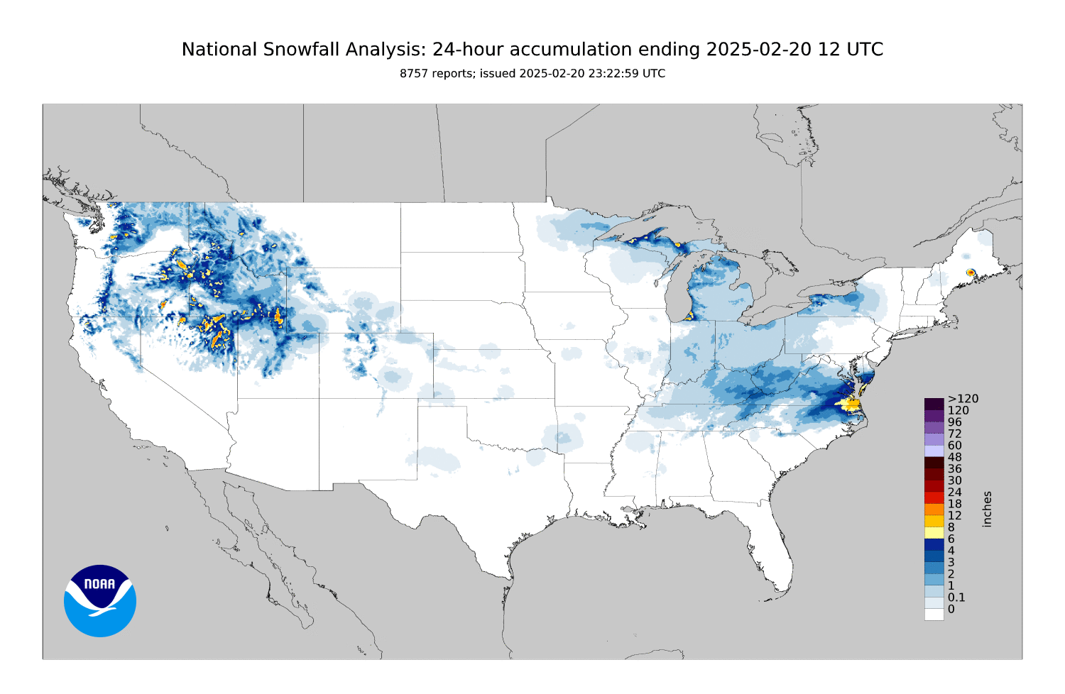
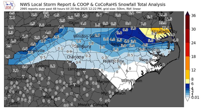
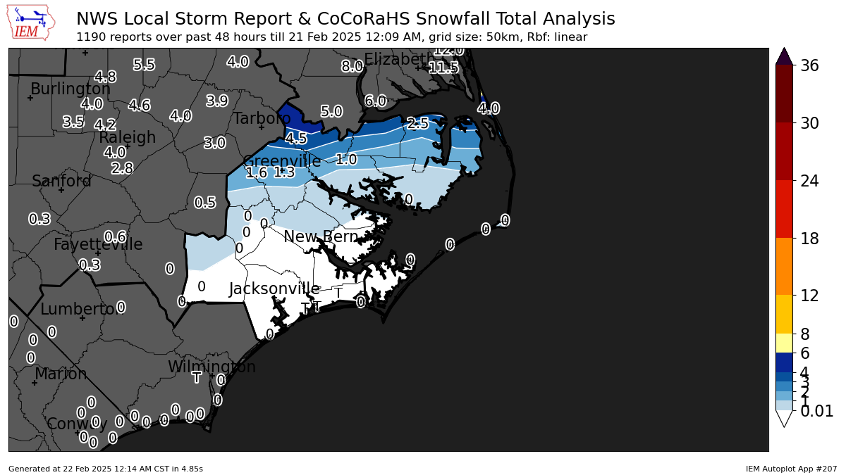
Maps of Observed Snowfall
Click images to enlarge
 |
 |
|
Observed Snowfall (National) |
Observed Snowfall (NC) |
 |
 |
|
Observed Snowfall (ENC) |
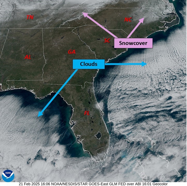
Snowcover as seen on visible satellite imagery |
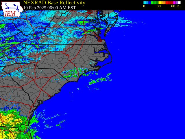
February 19-20 Regional Radar Loop
Click loop to enlarge
 |
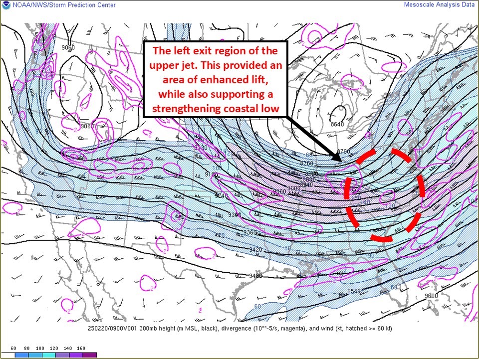
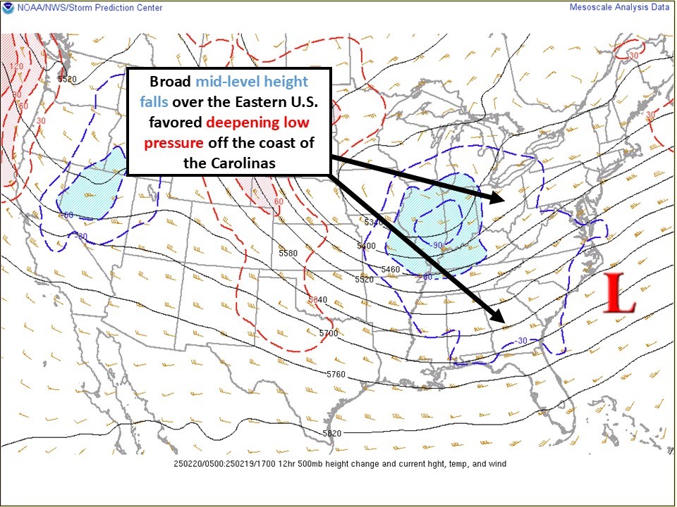
Winter Storm Environment Overview
Click images to enlarge
 |
 |
|
300 mb (4am, Feb 20) |
500 mb (12am, Feb 20) |
 |
 |
|
Surface (12am, Feb 20) |
Temperatures (12am, Feb 20) |
Pictures/Social Media
Currently, in #WintervilleNC, it's 31° and a mixed bag of precipitation.
— Chuck Copeland - Wx (@chuckcopelandwx) February 19, 2025
Mainly freezing rain for the last 30 minutes or so, but it quickly alternates between ZR, SN, & RN.#encwx #ncwx@ZachHolderWx @NWSMoreheadCity @EthanClarkWX pic.twitter.com/nmxDZ8gUsP
Nature's Clearcoat for automobiles. 🧊
— Chuck Copeland - Wx (@chuckcopelandwx) February 19, 2025
Currently in #WintervilleNC, a light sleet/snow mix. #encwx #ncwx @ZachHolderWx @NWSMoreheadCity @EthanClarkWX pic.twitter.com/DVJNDvu0iJ
@NWSMoreheadCity Ice accumulating on tops of pine trees of hwy 24 in Newport. pic.twitter.com/la55mpx5dG
— Steven Pearce (@stvnprc) February 19, 2025
First glimpse of snow @WITN. Big flakes but still sleet and freezing rain mixing in. #ncwx @NWSMoreheadCity pic.twitter.com/MUg27oFDSk
— Zach Holder (@ZachHolderWx) February 19, 2025
447 pm - Rain has switched to mostly sleet here in Cedar Point, NC. There is a light accumulation of sleet. @NWSMoreheadCity #ncwx pic.twitter.com/mNVRvGDmws
— Roger Martin III (@RM3wx) February 19, 2025
Southern shores taken by my dad about 5 mins ago pic.twitter.com/CQr1Gw9qns
— Hunter (@HunterEncwx) February 19, 2025
Freezing rain/Sleet mix near Vanceboro, NC, got more coverage of sleet here than expected so far! @NWSMoreheadCity pic.twitter.com/rR2JAmMSSn
— Brady (@SouthEastWX_) February 20, 2025
About 1.5” of accumulation so far but a good .15” of that is ice. pic.twitter.com/xA8NbS6yNf
— Brady (@SouthEastWX_) February 20, 2025
SleetStorm ll: The Glistening Update:
— Chuck Copeland - Wx (@chuckcopelandwx) February 20, 2025
1.25" of sleet accumulation
0.2" of ice accretion
Current precip, moderate #sleet.
1 mile SE of #WintervilleNC#encwx #ncwx @NWSMoreheadCity @ZachHolderWx @EthanClarkWX pic.twitter.com/5M1C0lYQuV
Vanceboro, NC pic.twitter.com/INANJymevt
— Brady (@SouthEastWX_) February 20, 2025
Current view US 64 and Hwy 17 courtesy of Martin County Emergency Management near Williamston. With clouds, and scattered flurries moving through, producing an additional dusting, improvement will be limited today. Anything slushy or wet this afternoon will freeze up tonight! pic.twitter.com/BlMbyaA4JU
— NWS Newport/Morehead (@NWSMoreheadCity) February 20, 2025
A little bit of back-end #snow to top off our sleet cake with some powdery goodness.#WintervilleNC #encwx #snOMG @NWSMoreheadCity @ZachHolderWx @EthanClarkWX pic.twitter.com/rlKO89O6aI
— Chuck Copeland - Wx (@chuckcopelandwx) February 20, 2025
@SCweather_wx @NWSMoreheadCity
— Brady (@SouthEastWX_) February 20, 2025
Vanceboro, NC pic.twitter.com/mcev4fe63e
Had a not so fun drive into work as we saw 1-2” of snow here in portions of Pitt County. It was all worth it as we tag teamed round 3 of winter weather coverage. @wattsupbrent @NWSMoreheadCity @EthanClarkWX pic.twitter.com/KjE8TKEqG2
— Dustin Staples (@StaplesWeather) February 20, 2025
Stantonsburg between Greenville & Farmville is rough travel. Definitely recommend anyone needing to go between towns to take a different route! pic.twitter.com/bRGGHJSk7w
— themolluskk (@themolluskka) February 20, 2025


 Map View
 Weather Hazard Briefing (when applicable)
 Forecaster Discussion
 Marine
 Text Products
.png) Skywarn
Skywarn Submit Storm Reports
 Coastal Flood
.png) Surf Forecast/Rip Currents
Surf Forecast/Rip Currents