Wintry Precipitation Event, February 16-17, 2015
Summary
Low pressure tracked across the northern Gulf Coast states, then across central Georgia and South Carolina and off the North Carolina coast near Wilmington during the evening of Monday February 16, 2015. The low then accelerated off the North Carolina coast and moved well offshore by Tuesday afternoon February 17. With cold high pressure nosing down the eastern slopes of the Appalachians, the stage was set for wintry precipitation across most of eastern North Carolina. Surface temperatures were near or below freezing across most of the region, though temperatures would rise dramatically near the coast as a coastal front moved north and west onshore during the overnight hours Tuesday.
The 7 PM EST (00Z) sounding from Newport/Morehead City (MHX) showed a pronounced warm nose aloft (Figure 1), conducive for sleet and freezing rain. While a few reports of snow were observed, the predominant precipitation type during the event was sleet and freezing rain. Widespread power outages were noted with numerous downed limbs and powerlines across portions of the Coastal Plains, with Pitt, Martin, Lenoir, Craven, Duplin, Onslow and Jones Counties the hardest hit (Figure 2). Closer to the coast, precipitation fell as mostly rain, with rainfall amounts of over an inch common.
Forecasting Precipitation Type in Eastern North Carolina
Precipitation type can be very difficult to forecast in eastern North Carolina, especially in association with wintertime coastal lows. The placement of the low is critical to the development of wintry precipitation as the counterclockwise flow around the low pulls cold air into the region. A low track over inland eastern North Carolina, will keep the colder air further inland and keep coastal areas in the warm sector, while a further offshore track pulls in deeper cold air and increases the likelyhood for wintry weather. Also of great importance is the temperature profile aloft. If the temperature profile stays at or below freezing through the entire atmosphere, then just snow will reach the ground. In some cases, a winter storm will pump in low-level warmer air from the Atlantic or Gulf of America. When this occurs, the snow will begin to melt as it falls through the warm layer. Depending on the depth of the warm layer, snow may or may not completely melt into rain before reaching the cold air dome just above the surface. If the snow flakes only partially melt, and then fall back through the cold air dome, they will reach the ground as sleet. If the snow is able to completely melt, the rain falling into a subfreezing layer produces freezing rain. With the 7 PM (00Z) sounding from Newport (see Figure 1) showing a warm nose aloft with temperatures above freezing, the precipitation type during this event was mostly sleet and freezing rain. Small changes in the temperatures at the surface or aloft can make a big difference in the type of weather that occurs over eastern North Carolina and makes forecasting winter weather in this area a challenge.
Social Media During Winter Weather Events
As Social Media continues to expand as a source for disseminating and receiving weather information, the Newport/Morehead City NWS Facebook and Twitter pages have become an active and useful source of information exchange for eastern North Carolina. Infographics such as the one below were viewed and shared by many eastern North Carolina residents. Besides sending out critical weather information from National Weather Service social media accounts during a weather event such as a winter storm, social media is also invaluable in gathering reports from the public to help us verify the ongoing weather situation.

Forecast and Verification Images

Forecast 24-Hour Probability of Freezing Rain greater than 0.10 inch issued Monday afternoon February 16, 2015.

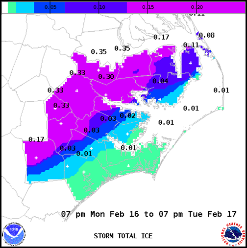
NWS Storm Total Ice Forecast for Monday February 16 through Tuesday February 17.

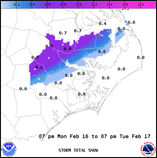
NWS Storm Total Snow for Monday February 16 through Tuesday February 17.
.gif)
Cocorahs map of Observed Snow Amounts from Tuesday morning February 17, 2015.
OTHER IMAGES
.gif)
Figure 1. The 00Z Newport/Morehead City, NC sounding showing a developing warm nose aloft.

Figure 2. Ice weighing down trees in Washington County, February 17, 2015. (Courtesy WITN TV).
PRELIMINARY LOCAL STORM REPORT...SUMMARY
NATIONAL WEATHER SERVICE NEWPORT/MOREHEAD CITY NC
604 AM EST WED FEB 18 2015

..TIME...   ...EVENT...      ...CITY LOCATION...     ...LAT.LON...
..DATE...   ....MAG....      ..COUNTY LOCATION..ST.. ...SOURCE....
            ..REMARKS..

0630 AM     FREEZING RAIN    KINSTON                 35.28N  77.59W
02/17/2015  E0.25 INCH       LENOIR             NC   EMERGENCY MNGR

            APPROXIMATELY .25 -.50 OF ICE ON THE GROUND. ROAD
            CONDITIONS ARE VERY DIFFICULT ALONG WITH POWER OUTAGES
            THROUGHOUT COUNTY..

0630 AM     FREEZING RAIN    GREENVILLE              35.60N  77.37W
02/17/2015  E0.25 INCH       PITT               NC   SPOTTER

0700 AM     FREEZING RAIN    1 N BATH                35.48N  76.82W
02/17/2015  M0.25 INCH       BEAUFORT           NC   COCORAHS

            .25 INCH OF ICE ON THE GROUND.

0700 AM     FREEZING RAIN    1 N GURGANUS            34.76N  77.66W
02/17/2015  M0.00 INCH       ONSLOW             NC   COCORAHS

            ICE ON POWER LINES AND BUSHES.

0830 AM     FREEZING RAIN    TRENTON                 35.06N  77.36W
02/17/2015  E0.33 INCH       JONES              NC   EMERGENCY MNGR

            A FEW TREES AND LIMBS DOWN WITH POWER OUTAGES.

0830 AM     FREEZING RAIN    VANCEBORO               35.30N  77.16W
02/17/2015  E0.25 INCH       CRAVEN             NC   EMERGENCY MNGR

            WIDESPREAD FREEZING RAIN NORTHERN PART OF COUNTY WITH
            TREES AND POWER LINES DOWN.

0831 AM     FREEZING RAIN    SNOW HILL               35.45N  77.67W
02/17/2015  E0.25 INCH       GREENE             NC   EMERGENCY MNGR

0835 AM     FREEZING RAIN    RICHLANDS               34.90N  77.55W
02/17/2015  E0.25 INCH       ONSLOW             NC   EMERGENCY MNGR

            WIDESPREAD FREEZING RAIN NORTHWEST PART OF COUNTY. SOME
            TREE LIMBS DOWN.

0838 AM     FREEZING RAIN    PLYMOUTH                35.86N  76.75W
02/17/2015  E0.25 INCH       WASHINGTON         NC   EMERGENCY MNGR

            LOCAL POWER OUTAGES. ROADS SLIPPERY.

0845 AM     FREEZING RAIN    WILLIAMSTON             35.85N  77.06W
02/17/2015  E0.33 INCH       MARTIN             NC   EMERGENCY MNGR

            ROADS SLIPPERY. LOCAL POWER OUTAGES DUE TO FALLING TREE
            LIMBS.

0850 AM     FREEZING RAIN    KENANSVILLE             34.96N  77.97W
02/17/2015  E0.33 INCH       DUPLIN             NC   EMERGENCY MNGR

            SOME TREES AND LIMBS DOWN. LOCAL POWER OUTAGES.


&&
|