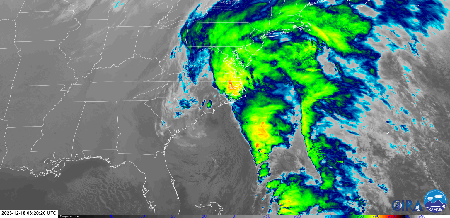
 On Saturday, December 16th, an area of low pressure began to develop and get more organized in the Gulf of America. That low continued to strengthen, eventually cross over the panhandle of Florida early Sunday morning (17th) and directly over our area Sunday night into Monday morning (17th - 18th). The storm would cause record coastal flooding in Charleston, SC, spawned a tornado near Myrtle Beach, set multiple low pressure records for the month of December and caused flooding and hurricane force wind gusts throughout the Northeast.
This storm, a Nor'easter, brought widespread heavy rainfall, isolated flash flooding, gusty winds, severe weather and significant coastal flooding to portions of Eastern North Carolina. This storm is a classic reminder that winter storms can bring impacts equal to that of a tropical storm or low end hurricane. We are vulnerable to strong wind and flooding throughout the ENTIRE year, due to our proximity to the coast. A few of the more notable impacts were flash flooding in Duplin County, significant ocean over wash on Hatteras and Ocracoke Island and a low pressure record for December at Cape Hatteras (984 MB).
**We will continue to update this page as new information, pictures, and reports come in. Please check back for later updates to this summary.**
Flooding
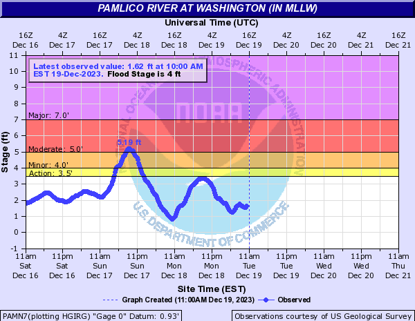
Coastal Flooding
 |
| Strong southeast winds pushed water toward the western end of Pamlico Sound and up the Pamlico River, causing flooding in Washington. |
|
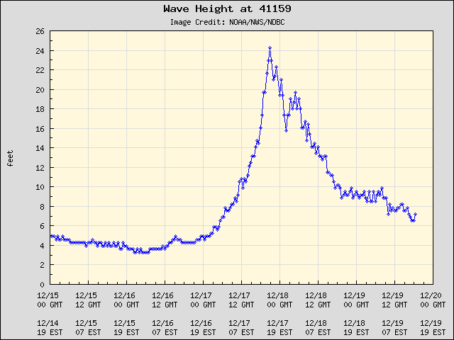
With gusts close to hurricane force off our coast, some of the highest waves over the Gulf Stream approached 30 feet here at Diamond Buoy! |
|
Significant over wash caused Highway 12 on Ocracoke to be closed for a time near the Pony Pen area. Credit: Island Free Press. |
|
Ocean over wash and multiple dune breaches caused Highway 12 to be closed from south of Frisco to Hatteras Village in the area of Sandy Bay. This view courtesy of NC DOT is north of Hatteras Village. |
 |
| Waves in Onslow Bay (off the Crystal Coast) peaked around 24 feet. While over wash was not as significant along the Crystal Coast, estimated water levels were 2 feet above normally dry ground along Bogue Sound, and the White Oak River. |
Inland Flooding
Flooding Storm Reports
Preliminary Local Storm Report...Summary
National Weather Service Newport/Morehead City NC
1049 PM EST Sun Dec 17 2023

..TIME...   ...EVENT...      ...CITY LOCATION...     ...LAT.LON...
..DATE...   ....MAG....      ..COUNTY LOCATION..ST.. ...SOURCE....
            ..REMARKS..

0908 PM     Flash Flood      2 SW Warsaw             34.98N 78.11W
12/17/2023                   Duplin             NC   911 Call Center

            Car stranded in the water on Sam Miller
            Road, water rescue ongoing.

0934 PM     Flash Flood      3 NNW Magnolia          34.93N 78.07W
12/17/2023                   Duplin             NC   Law Enforcement

            Law enforcement reported a couple of water
            rescues along Highway 117 between Warsaw and
            Magnolia.

1000 PM     Flash Flood      2 E Calypso             35.15N 78.08W
12/17/2023                   Duplin             NC   911 Call Center

            Water across Albritton Road, making it
            impassable.

1000 PM     Flash Flood      3 NW Calypso            35.18N 78.14W
12/17/2023                   Duplin             NC   911 Call Center

            Water across Robert Hargrove Road making it
            impassable.

1000 PM     Flash Flood      2 NNW Bowdens           35.08N 78.12W
12/17/2023                   Duplin             NC   911 Call Center

            Water across the road along Highway 50 and
            Highway 117. Multiple cars stuck in water
            across the county.
1000 PM     Flash Flood      Faison                  35.12N 78.14W
12/17/2023                   Duplin             NC   Emergency Mngr

            Faison FD/EMS had 4 water rescues.
&&

$$

Heden
Rain Reports
Rainfall Totals
Precipitation Reports from the Nor'easter
Public Information Statement
National Weather Service Newport/Morehead City NC
953 AM EST Mon Dec 18 2023

...48HR PRECIPITATION REPORTS FOR DATES SATURDAY 12/16/2023-MONDAY 12/18/2023...

Location                     Amount    Time/Date       Provider

...North Carolina...

...Beaufort County...
Washington 1.0 SSW           3.84 in   0800 AM 12/18   COCORAHS
Pantego 0.4 WSW              3.71 in   0615 AM 12/18   COCORAHS
NC Fire RAWS No. 4           3.61 in   0846 AM 12/18   RAWS
Washington 3.1 ESE           3.56 in   0700 AM 12/18   COCORAHS
Bunyan RAWS                  3.41 in   0913 AM 12/18   RAWS
Washington 10.5 ESE          3.20 in   0700 AM 12/18   COCORAHS
Chocowinity 0.2 W            3.20 in   0800 AM 12/18   COCORAHS

...Carteret County...
Morehead City 5.1 WNW        3.08 in   0700 AM 12/18   COCORAHS
Morehead City 5.7 W          2.95 in   0700 AM 12/18   COCORAHS
Pine Knoll Shores 1.4 E      2.86 in   0700 AM 12/18   COCORAHS
Morehead City 6.0 WNW        2.83 in   0700 AM 12/18   COCORAHS
Morehead City 2.9 WNW        2.68 in   0710 AM 12/18   COCORAHS
Newport 1.7 SSE              2.60 in   0800 AM 12/18   COCORAHS
Newport 0.2 SW               2.53 in   0700 AM 12/18   COCORAHS
Emerald Isle 3 WSW           2.45 in   0924 AM 12/18   CWOP
Beaufort 3.8 N               2.42 in   0700 AM 12/18   COCORAHS
Atlantic Beach 0.6 W         2.33 in   0730 AM 12/18   COCORAHS
Newport (WFO MHX)            2.31 in   1200 AM 12/18   COOP
Beaufort 5.3 N               2.30 in   0800 AM 12/18   COCORAHS
Newport 2.5 W                2.18 in   0700 AM 12/18   COCORAHS
Morehead City 0.1 E          2.16 in   0800 AM 12/18   COCORAHS
Morehead City 0.6 NW         2.06 in   0700 AM 12/18   COCORAHS
Beaufort 3.7 NNW             2.03 in   0800 AM 12/18   COCORAHS
Swansboro 3.7 NNE            2.00 in   0700 AM 12/18   COCORAHS
Cape Carteret (COOP)         1.98 in   0700 AM 12/18   COOP
Cape Carteret 1.5 NE         1.98 in   0800 AM 12/18   COCORAHS
Croatan RAWS                 1.93 in   0848 AM 12/18   RAWS
Beaufort (MRH ASOS)          1.91 in   0858 AM 12/18   ASOS
Beaufort 3.4 NNW             1.90 in   0800 AM 12/18   COCORAHS
Beaufort 0.5 W               1.84 in   0800 AM 12/18   COCORAHS
Stella 2.5 SE                1.77 in   0700 AM 12/18   COCORAHS
Cape Carteret 1.0 NNW        1.75 in   0700 AM 12/18   COCORAHS
Beaufort 1.5 NNW             1.68 in   0700 AM 12/18   COCORAHS
Cedar Point 0.9 WSW          1.64 in   0538 AM 12/18   COCORAHS
Swansboro 2.7 NE             1.62 in   0800 AM 12/18   COCORAHS
Ocean 0.5 S                  1.58 in   0700 AM 12/18   COCORAHS
Williston 0.9 SW             1.36 in   0700 AM 12/18   COCORAHS
Emerald Isle 2.1 E           1.26 in   0700 AM 12/18   COCORAHS
Cedar Island RAWS            1.08 in   0925 AM 12/18   RAWS

...Craven County...
Trent Woods 0.9 WNW          4.11 in   0700 AM 12/18   COCORAHS
New Bern 1.4 WSW             4.04 in   0800 AM 12/18   COCORAHS
New Bern 5.3 SW              3.99 in   0702 AM 12/18   COCORAHS
New Bern 2.6 SW              3.90 in   0700 AM 12/18   COCORAHS
New Bern 1.5 NW              3.90 in   0921 AM 12/18   COCORAHS
River Bend 0.8 ENE           3.86 in   0700 AM 12/18   COCORAHS
New Bern 8.8 W               3.77 in   0700 AM 12/18   COCORAHS
Trent Woods 1.0 NNE          3.64 in   0635 AM 12/18   COCORAHS
New Bern RAWS                3.52 in   0917 AM 12/18   RAWS
Perrytown (COOP)             3.50 in   0700 AM 12/18   COOP
Trent Woods 1.3 SSE          3.50 in   0700 AM 12/18   COCORAHS
Trent Woods 1.2 ENE          3.42 in   0600 AM 12/18   COCORAHS
New Bern 3.8 S               3.10 in   0800 AM 12/18   COCORAHS
Brice Creek 0.9 WNW          3.08 in   0700 AM 12/18   COCORAHS
1 WNW Coastal Carolina Regio 2.71 in   0700 AM 12/18   COCORAHS
James City 2.5 S             2.66 in   0700 AM 12/18   COCORAHS
New Bern 1.3 NNE             2.60 in   0700 AM 12/18   COCORAHS
1 WSW Lake Lemon             2.60 in   0940 AM 12/18   AWS
James City 3 S               2.45 in   0940 AM 12/18   AWS
Bridgeton 0.3 SSE            2.43 in   0715 AM 12/18   COCORAHS
James City 2.0 S             2.40 in   0730 AM 12/18   COCORAHS
Havelock 3 S                 2.40 in   0940 AM 12/18   AWS
New Bern 7.3 ESE             2.36 in   0700 AM 12/18   COCORAHS
Havelock 1.9 SSE             2.34 in   0744 AM 12/18   COCORAHS
Cherry Point (NKT ASOS)      2.32 in   0856 AM 12/18   AWOS
New Bern 5.2 SE              2.19 in   0642 AM 12/18   COCORAHS
New Bern 12.1 SSE            2.15 in   0656 AM 12/18   COCORAHS
New Bern (EWN ASOS)          2.10 in   0854 AM 12/18   ASOS
Havelock 0.7 NW              1.61 in   0935 AM 12/18   CWOP

...Dare County...
Rodanthe 0.6 N               2.94 in   0715 AM 12/18   CWOP
Southern Shores 0.5 NNE      2.79 in   0700 AM 12/18   COCORAHS
Rodanthe 1.0 SSE             2.16 in   0700 AM 12/18   COCORAHS
Dare Bomb Range RAWS         2.06 in   0848 AM 12/18   RAWS
Nags Head 1.3 NW             2.02 in   0940 AM 12/18   AWS
Manteo 2.8 NW                1.95 in   0800 AM 12/18   COCORAHS
Frisco (HSE ASOS)            1.79 in   0851 AM 12/18   ASOS
Dare Bombing Range           1.73 in   0854 AM 12/18   RAWS
Manteo (MQI AWOS)            1.47 in   0930 AM 12/18   AWOS
Buxton RAWS                  1.42 in   0930 AM 12/18   RAWS
Dare Co Gnry Ran (2DP AWOS)  1.08 in   0756 AM 12/18   AWOS

...Duplin County...
Mount Olive 2.4 SW           6.45 in   0700 AM 12/18   COCORAHS
1.5 SE Wallace               3.44 in   0600 AM 12/18   UCOOP
Nc Fire Raws No. 3           3.44 in   0912 AM 12/18   RAWS
Rose Hill 0.1 NNW            3.17 in   0700 AM 12/18   COCORAHS
Wallace 6.2 ENE              2.95 in   0700 AM 12/18   COCORAHS
Albertson 1.2 WNW            2.76 in   0600 AM 12/18   COCORAHS
Wallace 14.8 E               2.60 in   0700 AM 12/18   COCORAHS
Wallace (ACZ AWOS)           1.74 in   0745 AM 12/18   AWOS

...Greene County...
Snow Hill                    3.78 in   0700 AM 12/18   COOP
Snow Hill 3.1 NNE            3.78 in   0800 AM 12/18   COCORAHS
Ayden 6.5 WNW                2.90 in   0700 AM 12/18   COCORAHS

...Hyde County...
Swan Quarter Ferry Terminal  2.15 in   0700 AM 12/18   COOP
Engelhard 0.8 NW             2.15 in   0700 AM 12/18   COCORAHS
Fairfield RAWS               2.11 in   0917 AM 12/18   RAWS
Swanquarter 0.4 NNE          1.95 in   0700 AM 12/18   COCORAHS
Ocracoke 0.2 ESE             1.58 in   0800 AM 12/18   COCORAHS
Engelhard (7W6 AWOS)         1.25 in   0750 AM 12/18   AWOS

...Lenoir County...
Kinston 4.4 WNW              2.93 in   0700 AM 12/18   COCORAHS
Kinston 3 N                  2.93 in   0800 AM 12/18   COOP
Kinston 7.0 SW               2.77 in   0700 AM 12/18   COCORAHS
Pink Hill 2.5 NE             2.74 in   0641 AM 12/18   COCORAHS
Kinston 5.1 WNW              2.70 in   0700 AM 12/18   COCORAHS
Kinston 4.7 ESE              1.92 in   0820 AM 12/18   COCORAHS

...Martin County...
Williamston 8.9 SSE          3.60 in   0607 AM 12/18   COCORAHS
Jamesville 6.1 SW            3.00 in   0700 AM 12/18   COCORAHS
Williamston (MCZ AWOS)       2.30 in   0740 AM 12/18   AWOS

...Onslow County...
1 NW Pumpkin Center          3.89 in   0900 AM 12/18   COCORAHS
Jacksonville (COOP)          3.77 in   0738 AM 12/18   COOP
Hoffman RAWS                 3.34 in   0910 AM 12/18   RAWS
Holly Ridge 3.7 E            3.23 in   0700 AM 12/18   COCORAHS
Sandy Run RAWS               3.02 in   0919 AM 12/18   RAWS
Sneads Ferry 1.2 SSW         2.96 in   0700 AM 12/18   COCORAHS
Lejeune Soil Monitor         2.91 in   0849 AM 12/18   RAWS
2 WNW New River Station      2.88 in   0700 AM 12/18   COCORAHS
Jacksonville 4.5 NW          2.80 in   0700 AM 12/18   COCORAHS
Jacksonville (NCA ASOS)      2.80 in   0856 AM 12/18   AWOS
Jacksonville 3.3 W           2.70 in   0800 AM 12/18   COCORAHS
Jacksonville 6.8 NW          2.68 in   0700 AM 12/18   COCORAHS
Holly Ridge 9.0 ENE          2.66 in   0618 AM 12/18   COCORAHS
Holly Ridge 4.8 E            2.49 in   0930 AM 12/18   CWOP
Richlands (OAJ AWOS)         2.45 in   0856 AM 12/18   AWOS
Hubert 3.7 ENE               2.20 in   0726 AM 12/18   COCORAHS
Sneads Ferry 1.7 SE          2.10 in   0930 AM 12/18   CWOP
Swansboro 2.8 WSW            1.84 in   0700 AM 12/18   COCORAHS
Hubert 4.9 SE                1.81 in   0624 AM 12/18   COCORAHS

...Pamlico County...
Bayboro 0.4 W                2.97 in   0940 AM 12/18   AWS
Grantsboro 4.6 SSW           2.88 in   0849 AM 12/18   COCORAHS
Lowland 0.2 SE               2.83 in   0700 AM 12/18   COCORAHS
Oriental 2.0 WSW             2.75 in   0900 AM 12/18   COCORAHS
Oriental 4.3 NNW             2.74 in   0700 AM 12/18   COCORAHS
Merritt 1.5 WSW              2.57 in   0600 AM 12/18   COCORAHS
Oriental 1.7 NE              2.40 in   0930 AM 12/18   CWOP
Oriental 5.2 NE              1.40 in   0700 AM 12/18   COCORAHS

...Pitt County...
Fountain 0.1 NE              4.47 in   0700 AM 12/18   COCORAHS
Winterville 3.5 W            3.99 in   0700 AM 12/18   COCORAHS
Greenville 2.8 ESE           3.91 in   0838 AM 12/18   COCORAHS
Greenville 7.3 SSE           3.61 in   0753 AM 12/18   COCORAHS
Greenville 7.1 SSE           3.59 in   0700 AM 12/18   COCORAHS
Greenville 5.0 SE            3.46 in   0800 AM 12/18   COCORAHS
Greenville 2.3 ESE           3.42 in   0700 AM 12/18   COCORAHS
Greenville 4.7 WNW           3.42 in   0800 AM 12/18   COCORAHS
Winterville 2.6 ENE          3.15 in   0815 AM 12/18   COCORAHS
Winterville 1.0 ENE          3.04 in   0700 AM 12/18   COCORAHS
Greenville (COOP)            2.05 in   1200 AM 12/18   COOP

...Tyrrell County...
1 E Kilkenny                 2.86 in   0940 AM 12/18   AWS
Gum Neck (COOP)              2.54 in   0630 AM 12/18   COOP
Columbia 0.8 NNE             2.50 in   0700 AM 12/18   COCORAHS

...Washington County...
Roper 2.4 NE                 5.91 in   0700 AM 12/18   COCORAHS
Pocosin Lakes RAWS           2.67 in   0917 AM 12/18   RAWS
Roper 9.8 ENE                2.45 in   0915 AM 12/18   CWOP
&&
Wind Reports
Wind Gusts
|
The graph above is from Cape Lookout and shows as the pressure fell across our area (green line), stronger winds (blue and red lines) occurred across the region. |
|
This is a sample of the highest wind gusts. The strongest winds occurred right along the coast and open waters where gusts between 55 and 70 MPH were common. Winds were much lower. See full list below. |
Wind Reports from the Nor'easter
..
Public Information Statement
National Weather Service Newport/Morehead City NC
941 AM EST Mon Dec 18 2023

...HIGHEST WIND REPORTS LAST 24 HOURS...

Location                     Speed     Time/Date       Provider

...North Carolina...

...Beaufort County...
Bath                         41 MPH    0635 PM 12/17   DAVIS

...Carteret County...
Cape Lookout CMAN            75 MPH    0515 PM 12/17   NDBC
Beaufort                     64 MPH    0418 PM 12/17   CWOP
Beaufort (MRH ASOS)          60 MPH    0535 PM 12/17   ASOS
Piney Island (NBT AWOS)      58 MPH    0256 PM 12/17   AWOS
Fort Macon (WxFlow)          58 MPH    0525 PM 12/17   WXFLOW
North River (WxFlow)         57 MPH    0536 PM 12/17   WXFLOW
Beaufort (Duke Marine Lab)   55 MPH    0536 PM 12/17   NOS-NWLON
Bogue Field (NJM ASOS)       54 MPH    0333 PM 12/17   AWOS
Cedar Island RAWS            50 MPH    0625 PM 12/17   RAWS
Newport 7.5 E                46 MPH    0255 PM 12/17   CWOP
Morehead City 4.7 W          44 MPH    0530 PM 12/17   CWOP
Atlantic Beach               40 MPH    0935 PM 12/17   DAVIS

...Craven County...
Cherry Point (NKT ASOS)      66 MPH    0334 PM 12/17   AWOS
New Bern (EWN ASOS)          49 MPH    0605 PM 12/17   ASOS
Havelock 0.7 NW              42 MPH    0355 PM 12/17   CWOP
JAMES CITY                   41 MPH    0415 PM 12/17   CWOP

...Dare County...
Avon (WxFlow)                67 MPH    0942 PM 12/17   WXFLOW
Frisco (HSE ASOS)            64 MPH    0622 PM 12/17   ASOS
Buxton (WxFlow)              58 MPH    0836 PM 12/17   WXFLOW
Real Slick (WxFlow)          55 MPH    0656 PM 12/17   WXFLOW
Oregon Inlet CG (WxFlow)     54 MPH    0721 PM 12/17   WXFLOW
KHK Resort (WxFlow)          53 MPH    0708 PM 12/17   WXFLOW
Nags Head                    52 MPH    0620 PM 12/17   CWOP
ECU Coastal Studies Institut 51 MPH    0640 PM 12/17   MESOWEST
Oregon Inlet (WxFlow)        51 MPH    0758 PM 12/17   WXFLOW
Dare Co Gnry Ran (2DP AWOS)  49 MPH    0508 PM 12/17   AWOS
Dare Bomb Range RAWS         49 MPH    0548 PM 12/17   RAWS
Frisco                       46 MPH    0630 PM 12/17   DAVIS
DVI11679                     46 MPH    0705 PM 12/17   DAVIS
Rodanthe 0.6 N               46 MPH    0200 AM 12/18   CWOP
Buxton RAWS                  46 MPH    0730 PM 12/17   RAWS
Hatteras High (WxFlow)       46 MPH    0733 PM 12/17   WXFLOW
Manteo 0.2 E                 45 MPH    0600 PM 12/17   DAVIS
Buxton 0.7 SE                45 MPH    1200 AM 12/18   CWOP
Oregon Inlet Marina          44 MPH    0112 AM 12/18   NOS-NWLON
Manteo (MQI AWOS)            40 MPH    0730 PM 12/17   AWOS

...Hyde County...
Engelhard (7W6 AWOS)         40 MPH    0510 PM 12/17   AWOS

...Onslow County...
Sneads Ferry 1.7 SE          51 MPH    0345 PM 12/17   CWOP
Jacksonville (NCA ASOS)      51 MPH    0407 PM 12/17   AWOS
Jacksonville 1.7 NNW         48 MPH    0629 PM 12/17   CWOP

...Pamlico County...
Oriental 1.7 NE              44 MPH    0730 PM 12/17   CWOP

...Washington County...
Tidewater Research Station   42 MPH    0845 PM 12/17   NC-ECONET
Creswell 2.6 SSW             41 MPH    0700 PM 12/17   CWOP

...Maritime Stations...
Pamlico Sound (WxFlow)       70 MPH    0558 PM 12/17   WXFLOW
Diamond Buoy (41025)         69 MPH    0600 PM 12/17   NDBC
Onslow Bay Buoy (41064)      67 MPH    0508 AM 12/18   NDBC
Frisco Woods (WxFlow)        67 MPH    0636 PM 12/17   WXFLOW
Ocracoke                     67 MPH    0436 PM 12/17   WXFLOW
Jennettes Pier (WxFlow)      62 MPH    0703 PM 12/17   WXFLOW
Duck Pier                    58 MPH    0712 PM 12/17   NOS-NWLON
Avon Sound (WxFlow)          57 MPH    0100 AM 12/18   WXFLOW
Crab Point (Wx Flow)         56 MPH    0956 PM 12/17   WXFLOW
Croatan Sound (WxFlow)       53 MPH    0634 PM 12/17   WXFLOW
&&
Pictures/Social Media
Here are a couple photos of standing water on NC Highway 12 and a parking area near the pony pasture on Ocracoke Island. pic.twitter.com/pCL8WRG44L
— Cape Hatteras National Seashore (@CapeHatterasNPS) December 18, 2023
A few shots from the closed section of NC12 on the north end of Ocracoke Island. We are working to reopen this section of highway sometime later today. pic.twitter.com/Q8KvhuU9H9
— NCDOT NC12 (@NCDOT_NC12) December 18, 2023
https://t.co/V7VepQygtu webcam image of NC Highway 12 at the north end of Ocracoke Island. pic.twitter.com/aJXkNaGaQL
— Cape Hatteras National Seashore (@CapeHatterasNPS) December 18, 2023
Crews are arriving at the closed sections of NC12 (the north end of Ocracoke Island and between Hatteras and Frisco) to begin clearing and assess damage. The remainder of NC12 is open and passable, with many areas of standing rainwater and blown sand, so please drive carefully. pic.twitter.com/ppQO8DVjRk
— NCDOT NC12 (@NCDOT_NC12) December 18, 2023
The closed section of NC12 between Hatteras and Frisco will reopen at 4. HOWEVER, as you can see from the photo, there is still deep water in the area... 12" in spots. Drive with extreme caution, and if you have a low clearance vehicle, wait until tomorrow if at all possible. pic.twitter.com/mrTWiXvxmi
— NCDOT NC12 (@NCDOT_NC12) December 18, 2023
ðŸŒ§ï¸ Heavy rain in the East resulted in damaging and deadly flash flooding over the last few days. This graphic shows the low track and estimated precipitation with annotated wind gusts, locations of new pressure records, and areas with the worst flash flooding. pic.twitter.com/74wV235YBP
— NWS Weather Prediction Center (@NWSWPC) December 19, 2023