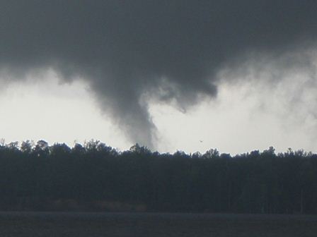
A Severe Thunderstorm Watch was issued for all of the Morehead City County Warning Area at 145 pm, mainly for the threat of hail and isolated tornadoes. The initial Severe Thunderstorm Warning was issued at 1:28 pm for Central Craven and Central Jones counties as an isolated thunderstorm developed a high reflectivity core along with a rapidly increasing VIL. A report of penny size hail was received at 150 pm from Cove City in Craven County. This storm continued to intensify and take on supercell characteristics over Craven County with increased gate-to-gate shear and high reflectivity cores. As the storm continued to intensify, a Severe Thunderstorm Warning was issued for western sections of Craven and Beaufort counties at 2:45 pm which was upgraded to a tornado warning at 259 pm. This storm was now a well-developed supercell with persistent rotation, characterized by strong gate-to-gate shear values and numerous TVS detections. As the storm moved into southern Beaufort County, numerous reports of penny to quarter-sized hail were received from areas south and east of the Washington/Chocowinity area. Around 320 to 330 pm, several reports of funnel clouds were received from the River Road area just east of Washington, with reports of the funnel cloud touching down around 345 pm on the south side of the Pamlico River. Eyewitness reports were relayed with pictures of the funnel touching down, along with reports of quarter sized hail (figure 3). This supercell started to collapse and then started to backbuild to the southwest as a second supercell redeveloped on the outflow boundary from the initial supercell over far southeastern Beaufort County. A new tornado warning was issued at 3:39 pm as the second supercell quickly intensified with strong rotation indicated through a deep layer. This storm tracked slowly northward with reports of nickel sized hail 3 miles south of Chocowinity. As this supercell slowly approached the Chocowinity/Washington area, webcams from WITN TV in Washington detailed the formation and touchdown of the funnel cloud just south of Washington. Based on the TV reports and numerous spotter reports, a third tornado warning was issued for Beaufort County at 430 pm and extended to cover portions of Greene and Martin counties. As the storm exited Beaufort County, rotation diminished and the event transitioned into more of a hail event with elevated high reflectivity cores and increased VIL values. Numerous reports of dime sized hail were received just before 5 pm from Pitt County. Additional hail reports were received in Martin County between 6 and 6:45 pm. Due to the slow movement of the storm, three separate Severe Thunderstorm Warnings were issued for portion of Pitt and Martin counties. As this second supercell finally began to wane, additional thunderstorms approached the area from the west through the late evening hours, as another mid-level shortwave rotated around the based of the closed 500 mb low.
4/20/08 Hydrology
A series of boundaries over the region, the most obvious of which was the convergence zone over the coastal plains near the center of the surface low, were over the CWA on Sunday. A strong conveyor belt of moisture streaming into the area from the Gulf Stream persisted throughout the event. This constant feed of moisture allowed for heavy rainfall in convection. An outflow from the supercell over Beaufort county collided with the lingering boundary over the coastal plains in over portions of Pitt and Martin counties around 500 pm. Severe thunderstorms resulted, but produced large amounts of hail contamination in the radar precipitation products. After about an hour of training over central Martin and north central Pitt county, a hydrologic advisory was issued for nuisance flooding of low lying areas and poor drainage areas. By 700 pm the rainfall had not let up, and reports of roadways becoming covered in water over local road 903 were coming in. The flood advisory was upgraded to an areal flood warning for Martin county. No significant flooding was reported.
Hail Event of April 21, 2008 – Round Two
By the mid-morning hours of April 21, the main surface low had moved offshore with a generally easterly low-level flow. This was keeping plentiful moisture in the boundary layer. The core of the 500 mb closed low was over moisture in the boundary layer. The core of the 500 mb closed low was over Eastern North Carolina. With a 500 mb temperature of -21C on the 12Z MHX sounding, the atmosphere became unstable with heating over Eastern North Carolina. A mesoscale discussion was issued for the area in the late morning (figure 4) stating that a watch was unlikely, but that marginally severe hail was possible, with an isolated tornado not out of the question. Thunderstorms began to develop between 16Z and 17Z and become numerous.
The initial warning of the day was issued at 12:51 as an isolated storm developed over Carteret County just west of the office. This storm quickly developed a hail spike with a high reflectivity core. Storms formed quickly and moved inland over the Central and Western Coastal Plains and became severe with large hail.
Warning Operations
During a 4-hour period from approximately 1 pm to 5 pm, there were 14 Severe Thunderstorm Warnings issued with 11 verifiying, all with hail. There were also 3 areal flood advisories issued with no reports of flooding.
4/21/08 Hydrology
Early in the day, banded showers wrapping around the low trained over the far eastern portions of the CWA. Rainfall amounts ranged from 2 to 3 inches, with locally heavier amounts in convection from Ocracoke, up the Outer Banks, and north through Columbia. Flood watches and eventually flash flood warnings were issued across the Albemarle sound in AKQ area during the afternoon. Rainfall amounts were insufficient to produce anything more than nuisance flooding over our counties. Two areal flood advisories were issued for ponding of water on low lying areas and poor drainage areas for Tyrrell, Dare, and Hyde counties from noon through early afternoon. Heavy convective showers were observed over central and western counties, however rainfall amounts were again insufficient to produce flooding. FFMP did show values exceeding flash flood guidance, but large amounts of hail contamination prevented accurate rainfall values from the radar. There was a report of an accident on highway 101 in Newport due to hydroplaning.
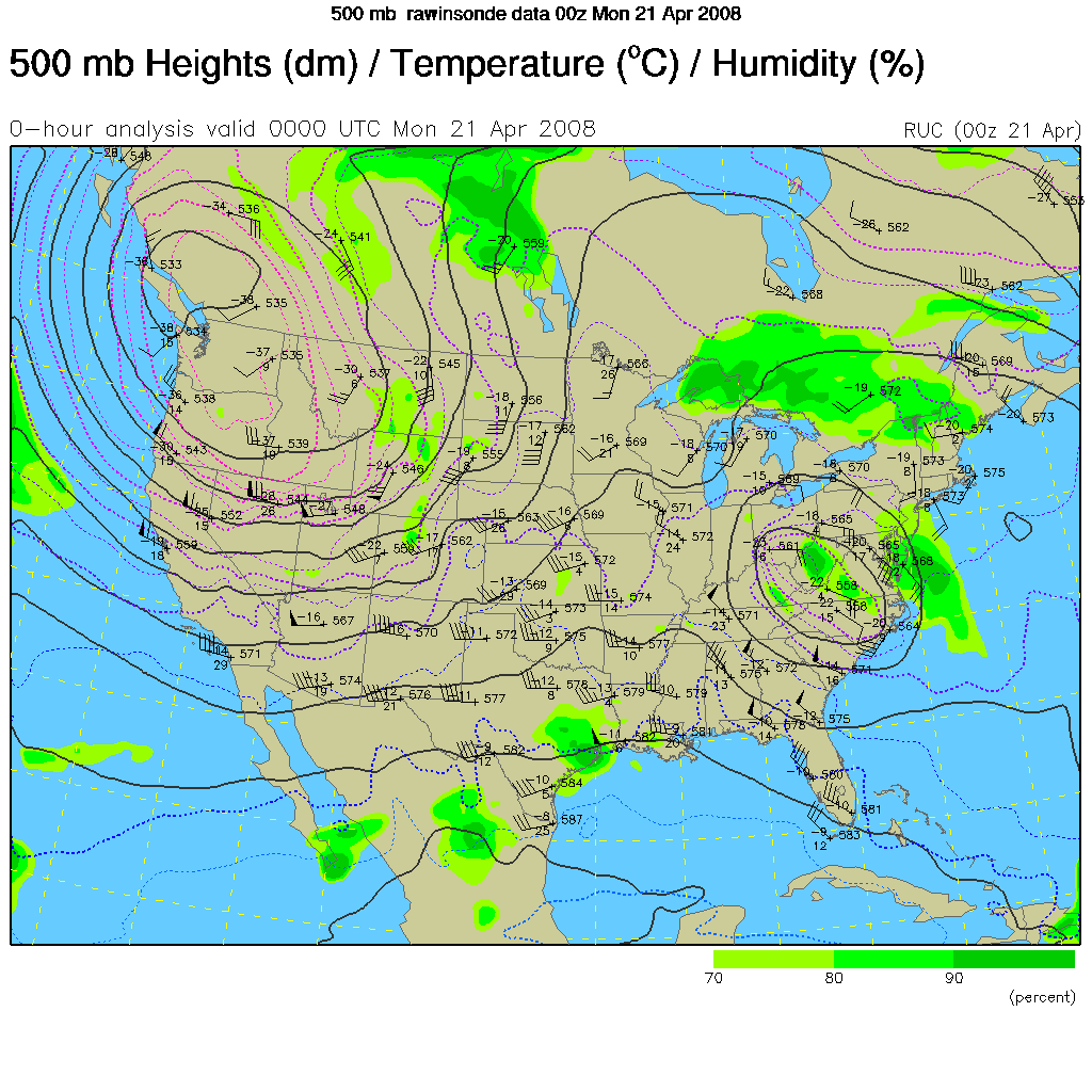
Figure 1. 500 mb Analysis 00Z April 21
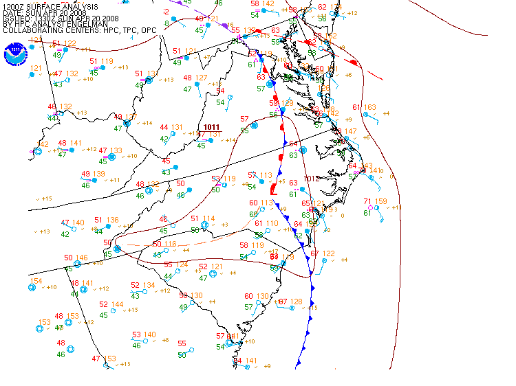
Figure 2. Surface Analysis 12Z April 20


 Map View
 Weather Hazard Briefing (when applicable)
 Forecaster Discussion
 Marine
 Text Products
.png) Skywarn
Skywarn Submit Storm Reports
 Coastal Flood
.png) Surf Forecast/Rip Currents
Surf Forecast/Rip Currents