Event Overview
On the evening of April 15, 1999, one of the most bizarre and unusual supercell thunderstorms ever observed roared across southeastern North Carolina. It produced several damaging tornadoes, one killer tornado, non-tornadic wind damage reports, and a measured wind gust to 165 mph.
The storm actually formed during the afternoon across the mountains of northeastern Georgia as part of a pre-frontal squall line before moving into the upstate region of South Carolina. It tracked eastward into the South Carolina Midlands where additional moisture and instability helped it intensify to severe limits. The storm moved out of northern South Carolina as a heavy-precipitation (HP) supercell, moving east-northeast close to the intersection of a warm front and a surface trough. It then moved east-northeast across southeasterrn North Carolina, producing a gust front on its rear flank on which more thunderstorm cells formed. That gust-frontal band, and the forward flank of the original storm, began to curve into spiral bands -- eventually assuming a hurricane shape (Figure 1).
The first report of damage came around 8 pm from a downburst east of Maxton in Robeson County, destroying a mobile home and injuring one. Soon after, a tornado developed just east of Pembroke. The twister destroyed four trailers in the Moss Neck area, trapping two people and sending several to the hospital. One man was killed when the trailer he was visiting fell and crushed him. Another tornado destroyed two mobile homes and a house in the East Howesville area between Lumberton and Tar Heel. The storm continued to strengthen as it moved into northern Bladen County. An F0 tornado developed around 9 pm just south of Tar Heel. It destroyed 6 mobile homes in the Monroe Trailer Park, injuring five. Further east, the storm produced a downburst which damaged a garage and destroyed a pair of grain silos west of White Oak. Trees were reported down farther east near Ammon.
As the system moved into the Newport/Morehead City area of responsibility (CWA), a multi-vortex tornado touched down in Duplin County about a half mile south of Kenansville. The tornado, which was an F2 at times, tracked east northeast between Pink Hill and Beulaville and just to the north of Potters Hill before entering Jones County. Once in Jones County the tornado passed just north of Hargetts Crossroads and tracked north of Route 41, ending near the intersection of Routes 58 and 41. The tornado track covered nearly 30 miles and rangedbetween a half mile to around one mile wide. A measured wind report of 165 mph was observed near Trenton. In total, hundreds of trees were knocked down, over 30 homes were destroyed, 60 homes suffered major damage, and a significant number of livestock were killed. Another tornado touched down in Onslow County about a mile south of Richlands and tracked across Highway 258 before dissipating in Hoffman Forest. Most of the damage was reported in Richlands, where nine dwellings were destroyed and seven people were injured. Later, a F1 tornado skipped across coastal communities of Downeast Carteret County destroyed a crab processing house in Davis and produced scattered structural damage from Davis to Atlantic.
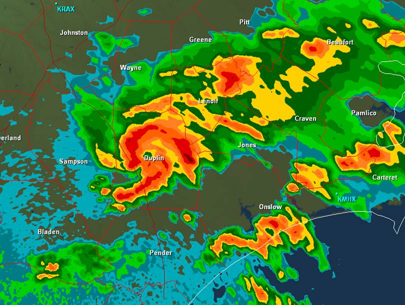
Figure 1. Radar Reflectivity around 9:39 pm April 15, 1999 shows supercell thunderstorm complex taking on the shape of a hurricane over Duplin County.
Synoptic Overview
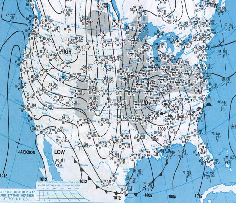
The 12Z surface map from April 15, 1999 showed strong low pressure over the Ohio Valley with a frontal boundary trailing south into Alabama with a warm front extending east to South Carolina (Figure 2). As this warm front lifted north into Eastern North Carolina, theairmass over the region became very unstable. At the upper levels, a deep 500 mb trough became negatively tilted over the lower Mississippi Valley leading to strong upper divergence across the Carolinas (Figure 3).
 .
.
Figure 2. Surface map from 12Z April 15, 1999 showing warm front over South Carolina.
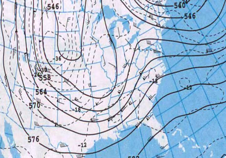
Figure 3. 500 mb Analysis at 12Z April 15, 1999 showing deep trough becoming negatively tilted over the lower Mississippi Valley with strong upper divergence developing over the Carolinas.
Radar Imagery
As the supercell-producing mesocyclone moved into Eastern North Carolina, the thunderstorm cluster assumed a hurricane-like shape, even forming an eye-like "hole" in the reflectivity field just east of the mesocyclone. New thunderstorms along the supercell'srear-flank gust front, and the original storm's forward-flank precipitation area, each became spiral bands curving inward toward the "eye" -- actually, a bounded weak-echo region (BWER) between the bands (Figure 4). During this hurricane-shaped echo stage, over Duplin County, a 1/2 to 1 mile wide tornado produced F2 damage, injured at least 11 people near Kenansville and Beulaville, and carved a 30 mile long path. Very strong rotation was observed on the Newport/Morehead City radar (Figure 5). Then the southern band (along the original rear-flank gust front) partially broke away, with a tornado reported near Catherine Lake (NW Onslow County) which injured seven. Meanwhile, the original HP supercell continued toward the east-northeast, producing more tornadoes and wind damage. The 165 mph gust north of Trenton was recorded at 10:20 p.m. EDT, from a Bounded Weak Echo Region (BWER) within the original HP supercell (Figure 6). Then, the original supercell began to evolve into a bow echo, and would spawn still more wind damage reports over Lenoir and Craven counties and a tornado over Carteret County.
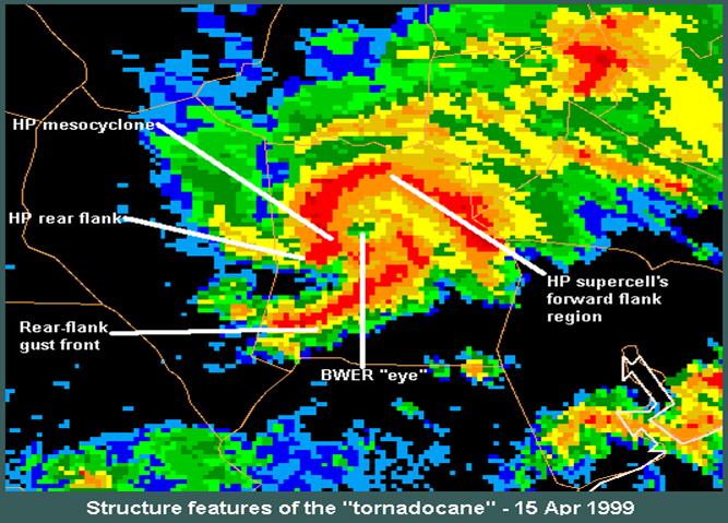
Figure 4. The structure of the “Tornadocane” of April 15, 1999 (image courtesy Storm Prediction Center)
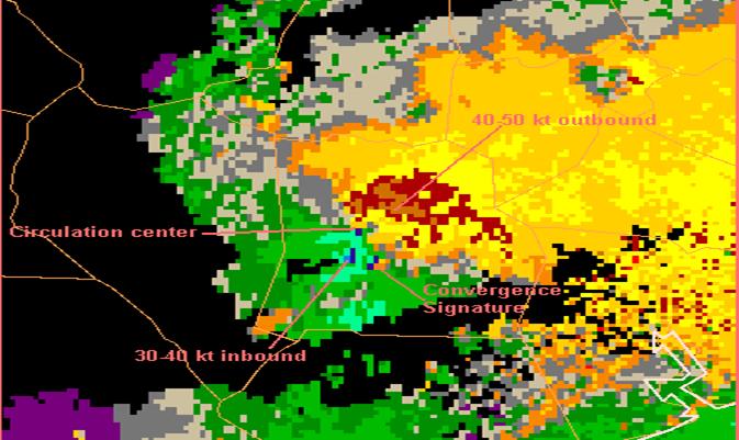
Figure 5. Storm Relative Velocity image at 941 pm April 15, 1999 showing strong rotation near the center of the “Tornadocane”supercell storm. (image courtesy of Storm Prediction Center)
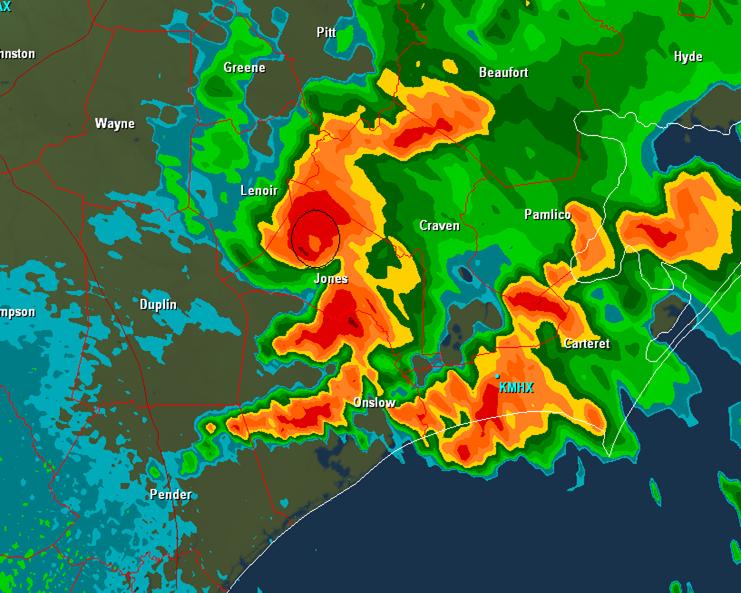
Figure 6. A 165-mph wind gust was reported in Jones County within a Bounded Weak Echo Region (black circle) in the original “Tornadocane” high-precipitation supercell at around 1019 pm April 15, 1999.
As the bow echo approached the coast, it weakened, but still produced one final damaging tornado (Figure 7) along the downeastsection of Carteret County, destroying a fish processing plant in Davis.
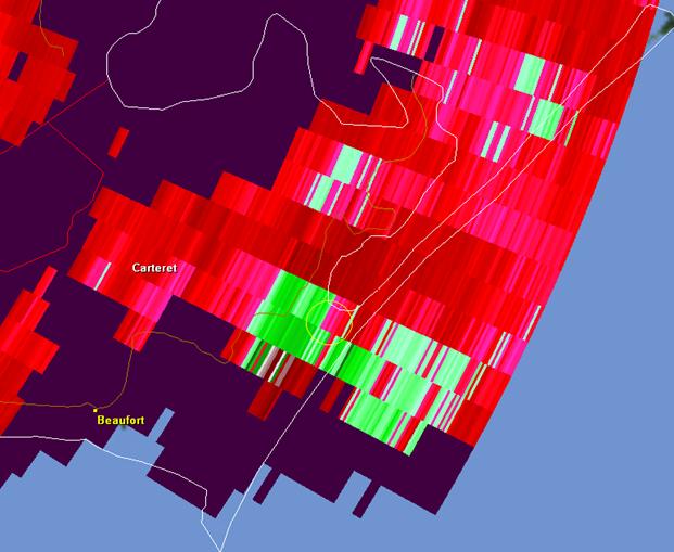
Figure 7. Rotational couplet (light yellow circle) near the Davis-Smyrna area of Carteret County produced a F1 tornado that destroying a fish-processing facility.
Sources
· Storm Prediction Center
· GRAnalyst2 Radar Software
· NOAA Daily Weather Maps
· National Weather Service, Wilmington, NC


 Map View
 Weather Hazard Briefing (when applicable)
 Forecaster Discussion
 Marine
 Text Products
.png) Skywarn
Skywarn Submit Storm Reports
 Coastal Flood
.png) Surf Forecast/Rip Currents
Surf Forecast/Rip Currents