April 12, 2008 Wet Downburst in Duplin County
Overview
An upper level trough was situated over the mid western U.S. with a surface cold front just east of the Appalachians early Saturday morning, April 12, 2008. Very strong and deep southwesterly flow was present over eastern North Carolina by afternoon with an 850 mb jet around 50 knots. The main severe weather threat by afternoon across eastern North Carolina was damaging straight line winds due to the strong unidirectional wind fields. Temperatures warmed into the mid 80s over the coastal plain with dewpoints in the lower 60s, leading to CAPE (Convective Available Potential Energy) values in the 1000 to 1500 j/kg range and LI’s (Lifted Index) between -4 and -5 by mid afternoon. Showers and thunderstorms developed ahead of the cold front along a pre-frontal trough over central South and North Carolina during the late morning and early afternoon hours. This activity moved into eastern North Carolina by mid afternoon before weakening by early evening as the more stable marine layer was encountered. The Storm Prediction Center had all of eastern North Carolina in a slight risk for severe thunderstorms and issued a severe thunderstorm watch shortly after 2 pm as the air mass destabilized.
Warning Event
Thunderstorms began to intensify across the coastal plain by early afternoon>with an intense cell developing over central Johnston county around 2:30 pm. This cell moved rapidly to the northeast and showed signs of fairly strong rotation which prompted the Raleigh WFO (Weather Forecast Office)to issue a tornado warning for portions of Johnston, Wayne and Wilson counties shortly after 3 pm. Several confirmed tornado reports were received with this storm with damage being reported in central and eastern Wayne county. The storm continued to race off to the northeast towards Greene county with rotation still present, although weakening. A tornado warning was issued for northern Greene and Pitt counties at 3:24 pm based on the tornadic history of the storm, along with weak to moderate rotation indicated on the 0.5 degree SRM (Storm Relative Velocity) cut. The public reported a tornado at 3:59 pm at the intersection of state Highway 903 and Highway 13 just north of Greenville, with several power poles reported down. Severe thunderstorm warnings were issued for portions of Beaufort, Martin, Washington and Tyrell counties between 4:00 pm and 5:30 pm as the same cell moved northeast into a more unstable air mass, showing signs of bowing. Another severe thunderstorm warning was issued for northwest Martin County around 3:30 pm as a small cell intensified in eastern Edgecombe county, with weak rotation and a decent reflectivity core present. The thunderstorm activity over northwest portions of the Newport/Morehead City CWA began to weaken during the late afternoon hours as they became outflow dominant and instability across the area weakened.
Further south, a second area of showers and thunderstorms developed around 4:00 pm in Bladen and Sampson counties just outside of the Newport/Morehead City CWA. These storms became better organized as they impinged on a more unstable air mass just south of Duplin county where LI’s were approaching -4. In addition, the storms would soon be intersecting an outflow boundary from the north and a westward moving sea breeze front. A severe thunderstorm warning was issued shortly after 4:30 pm for Duplin county as mid level reflectivities increased to around 50 dbz and the storm showed signs of bowing. The storm continued to strengthen and by 5:00 pm had very intense low level reflectivity values greater than 65 dbz at and below 14 thousand feet. In addition, the 0.5 degree velocity cut indicated wind speeds between 65-70 knots as the storm was exiting extreme northeast Duplin county. Several calls were received just after 5:00 pm with damage reported in northeastern Duplin county along state Highway 24 about 5 miles east of Beulaville. There was also a report of a possible funnel cloud in the area. The storm continued northeast into extreme northwest Onslow county and Jones county. An additional report of minor damage was received near Richlands in Onslow county around 5:20 pm. A tornado warning was issued for eastern Jones county and central Craven county as additional reports of funnel clouds were received and a weak couplet developed on the 0.5 degree cut. Wind gusts to 60 mph were reported near Trenton in central Jones county around 5:40 pm but no tornado or damage was reported. By 6:00 pm the storm began to quickly weaken across western Pamlico county, as it was undercut by the sea breeze front.
Damage Survey Report
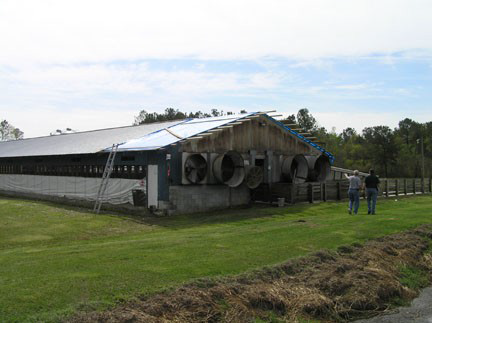
A damage survey was conducted by the Newport/Morehead City NWS the day after the event. The survey focused on the numerous wind damage reports across Duplin county. The storm first produced damage about 3 miles northeast of Chinquapin where a metal roof was completely torn off the south side of a modular home. Debris was scattered to the northeast in an open field. A distinct area of damage occurred along state highway 24 east of Beulaville around the 4200 block. Extensive damage was done to the roof of a hog house that typically holds around 600 hogs. About one quarter of the metal roof was torn off and scattered into some trees on the north side. A small out building was also destroyed to the east of the hog house with debris scattered in an open field just northeast of where it stood. In addition, a large empty, unanchored grain bin was toppled. The second damage area was about one half mile further east where an unsecured, abandoned mobile home was rolled and flattened. The owner of the mobile home lived in a house just west of where the mobile home was located and suffered additional wind damage to his metal fame carport as it was toppled and rolled about 50 feet. A small fiberglass boat was forced into the hood of antique automobile and resulted in considerable damage to the car as it buckled the front portion of the hood. The third area of damage occurred about a mile further to the east where the western side of a wooden out building was destroyed. The metal roof was torn off and lifted into a tall tree on the northeast side. A small wooden chicken pen also suffered considerable damage with several chickens being lost in the storm. NWS meteorologists talked with residents who sustained damage across northeast Duplin county and all eyewitness reports confirmed a downburst. Several residents remember an intense onslaught of heavy rain immediately followed by extreme winds. Doppler radar from the Newport/Morehead City site indicated between 60-70 knots of wind on the 0.5 degree velocity cut over extreme northeast Duplin county between 5:50 pm and 6:10 pm, along with low level reflectivity values around 70 dbz at fourteen thousand feet and 65 dbz at three thousand feet. Prior radar scans showed the higher reflectivities aloft. The descending high reflectivities indicated that the cell was collapsing and resulted in a wet microburst across the area. NWS meteorologists estimated the wind speeds to be between 80-90 mph across the area. Several reports of funnel clouds were also sited on the leading edge of the storm as it was moving across Duplin county. A bowing cell characteristic indicates damaging wind potential and often results in a shelf cloud developing on the leading edge. The shelf cloud can exhibit extreme turbulence with rotating eddies often visible. These visible eddies are often mistaken for funnel clouds. Small vortices on the leading edge of a convective gust front sometimes do reach the ground and are referred to as gustnadoes (gust front tornadoes). They usually only produce minor wind damage. Although funnel clouds or leading edge vortices were likely visible, the damage swath over northeast Duplin county fit a distinct linear pattern with debris scattered in a southwest to northeast fashion. The following pictures show the extent of damage associated with the Duplin county storm.


 Map View
 Weather Hazard Briefing (when applicable)
 Forecaster Discussion
 Marine
 Text Products
.png) Skywarn
Skywarn Submit Storm Reports
 Coastal Flood
.png) Surf Forecast/Rip Currents
Surf Forecast/Rip Currents