Hurricane Ginger, September 30, 1971
Event Overview
Hurricane Ginger was notable because of its longevity, circuitous track and as the final hurricane that Project Stormfury would seek to weaken by depositing silver iodide into the cyclone's rainbands. Ginger was the second-longest lasting Atlantic hurricane on record and the eighth tropical cyclone and fifth hurricane of the 1971 Atlantic hurricane season. Ginger spent 27.25 days as a tropical cyclone, lasting from September 6 to October 3 (Figure 1). Twenty of those days (September 11-September 30), Ginger was classified as a hurricane. The storm formed northeast of the Bahamas, and for the first nine days of its duration tracked generally eastward or northeastward while gradually strengthening to peak winds of 110 mph. On September 14, Ginger slowed and turned to a general westward track, passing near Bermuda on September 23. There, the hurricane produced gusty winds and high waves, but no major damage.
Ginger struck coastal North Carolina on September 30 near Emerald Isle (Figure 2) as a minimal hurricane, lashing the coastline with gusty winds that caused power outages across the region. Heavy rainfall flooded towns and left severe crop damage, with 3 million bushels of corn and 1 million bushels of soybean lost. Damage in the state was estimated at $10 million (1971 USD, $56.7 million 2013 USD). Further north, moderate precipitation and winds spread through the Mid-Atlantic states, although no significant damage was reported outside of North Carolina. After meandering inland to the north and east, Ginger emerged back over the Atlantic as a depression on the morning of October 3 and was absorbed by a cold front, quickly becoming extratropical.

Figure 1. Track of Hurricane Ginger, September 6 through October 3, 1971 (courtesy Wikipedia)
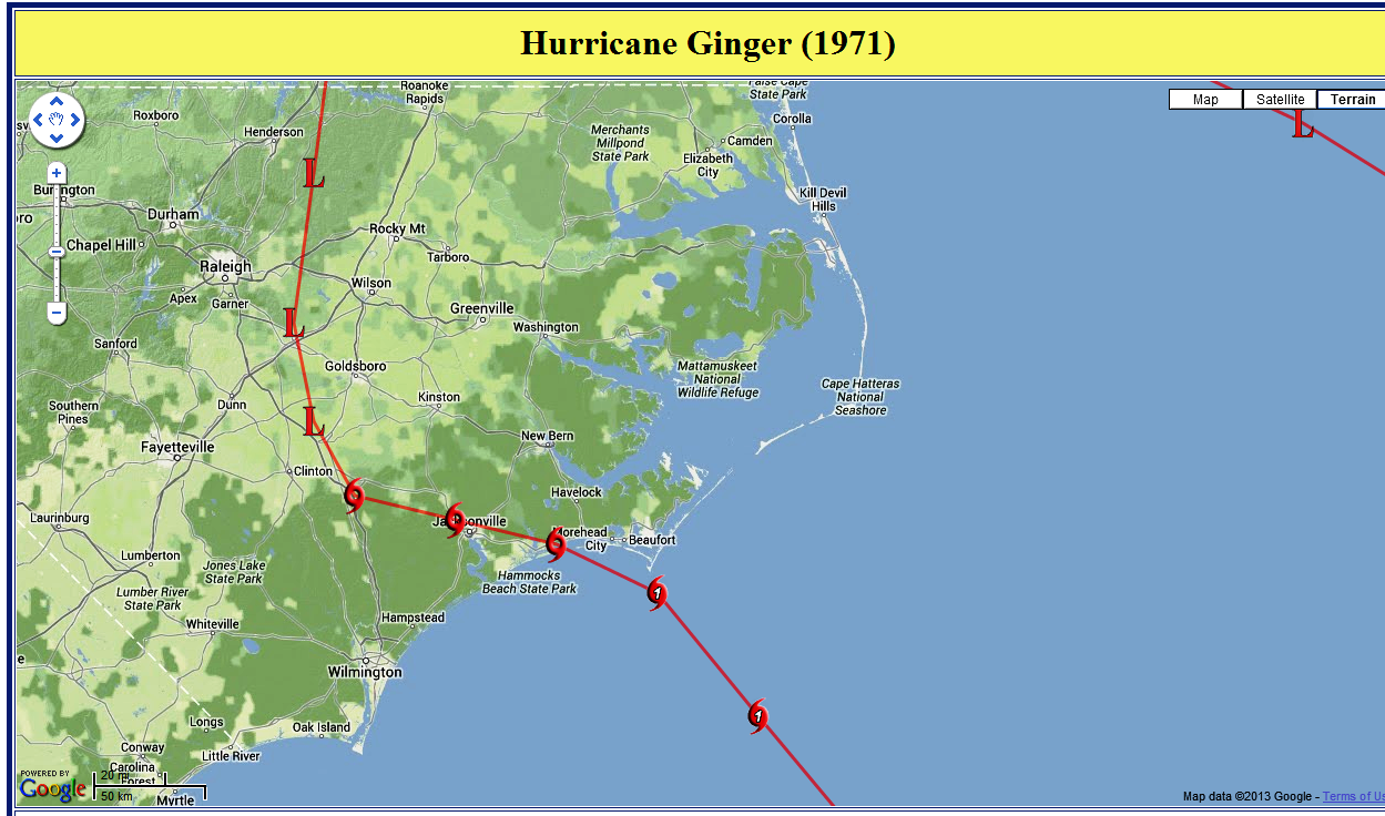
Figure 2. Zoomed-in track of Hurricane Ginger, September 30, 1971 (courtesy North Carolina Climate Office)
Evolution and Impacts
Hurricane Ginger originated in a cold-core upper-level low that persisted for several days in early September in the western Atlantic Ocean. By September 5, the low had descended to the surface as its thermal structure warmed, and the next day it developed into a tropical depression about 235 mi northeast of the Bahamas.
After forming, the depression moved slowly southeastward for about 24 hours before turning to the northeast, slowly organizing in the process. On September 10, the depression turned eastward, and later that day intensified into Tropical Storm Ginger, about 325 miles south of Bermuda. The storm quickly intensified, and within 24 hours reached hurricane force. It turned to the northeast, passing well to the east of Bermuda. Late on September 13, Ginger attained its minimum barometric pressure of 959 MB (28.32 inHg), and early the next day reached peak maximum sustained winds of 110 mph. About halfway between Bermuda and the Azores, the hurricane's eastward movement halted due to a building ridge to its north and east. It turned sharply southward before turning and beginning a westerly drift, during which Ginger weakened to minimal hurricane status.
For about six days, Ginger maintained minimal hurricane status. As it meandered over the central Atlantic Ocean, it maintained an unusually large eye, reaching 80 mi in diameter. On September 18, Ginger turned to the south and slowly executed a tight counterclockwise loop within three days. By September 21, the hurricane was tracking south of due west, and the next day suddenly intensified to winds of 90 mph. Its westward track briefly posed a threat to Bermuda, although Ginger passed 115 miles south of the island on September 23 while slowly weakening. On September 24, Ginger decelerated before beginning a turn to the southwest. By September 26, Ginger briefly weakened to minimal hurricane strength, although re-intensification resumed as the track turned to the west and northwest. Around that time, Ginger absorbed the smaller and weaker Tropical Storm Janice to its southeast.
As Ginger made landfall as a Category 1 hurricane near Emerald Isle, wind gusts were reported as high as 92 mph in Atlantic Beach, 72 mph at Cape Hatteras and 58 mph at Topsail Beach. The strong winds from Ginger damaged store fronts and windows, and also downed power lines and trees. Morehead City, New Bern, Beaufort and Atlantic Beach lost power. Tides along the Crystal Coast were about 4 feet above normal with tides as high as 6 to 7 feet above normal over the Pamlico Sound at Washington, Aurora, New Bern and Cherry Point. Up to 4 feet of water from the Pungo River flooded most of the city of Belhaven, and similar flooding occurred in Washington, entering dozens of buildings and houses. The storm dropped heavy rainfall with many locations recording over 10 inches (Figure 3), peaking at 15.58 inches on Bodie Island along the Outer Banks. The heavy rain caused the Neuse and Trent Rivers to overflow their banks, resulting in flooding. Across the region, the combination of high winds, tides and flooding closed several bridges and roads, including a portion of U.S. Highway 70. The winds also destroyed a number of mobile homes. During Ginger's passage, the Salvation Army and Red Cross provided more than 3,000 people with food assistance.
Further inland, the combination of strong winds and rains left heavy crop damage, destroying 3 million bushels of corn and another million bushels of soybeans. Heavy damage was also reported to the peanut crop as well as to various fruits and vegetables. In some locations, up to 15% of the cotton crop was lost, particularly in the northeastern portion of the state. Total damage in North Carolina was estimated at $10 million (1971 USD, $56.7 million 2013 USD), of which about $1 million (1971 USD, $5.67 million 2013 USD) was from coastal flooding. No deaths were reported in eastern North Carolina as the result of Hurricane Ginger.

Figure 3. Rainfall associated with Hurricane Ginger, September 30, 1971.
Sources
National Hurricane Center
Weather Prediction Center
Wikipedia
Associated Press
IMAGES FROM GINGER (Davis, NC) Photos courtesy Associated Press


Case Review Team:
Chris Collins


 Map View
 Weather Hazard Briefing (when applicable)
 Forecaster Discussion
 Marine
 Text Products
.png) Skywarn
Skywarn Submit Storm Reports
 Coastal Flood
.png) Surf Forecast/Rip Currents
Surf Forecast/Rip Currents