|
Widespread thunderstorms bring heavy rain and spotty severe weather |
|
 |
|
| Lubbock WSR-88D radar animation valid from 3:23 am to 11:21 am on Saturday (2 November 2024). | |
|
Following a record warm October and a prolonged stretch of dry weather from mid-summer into fall, the weather did a complete 180, turning cooler and wetter at the start of November. The dramatic shift was thanks to a seasonally strong cold front coupled with several disturbances moving overhead. Adding fuel to the fire, abundant Gulf moisture sitting downstate was drawn northwestward, leading to widespread and heavy rainfall with numerous thunderstorms. |
|
 |
|
|
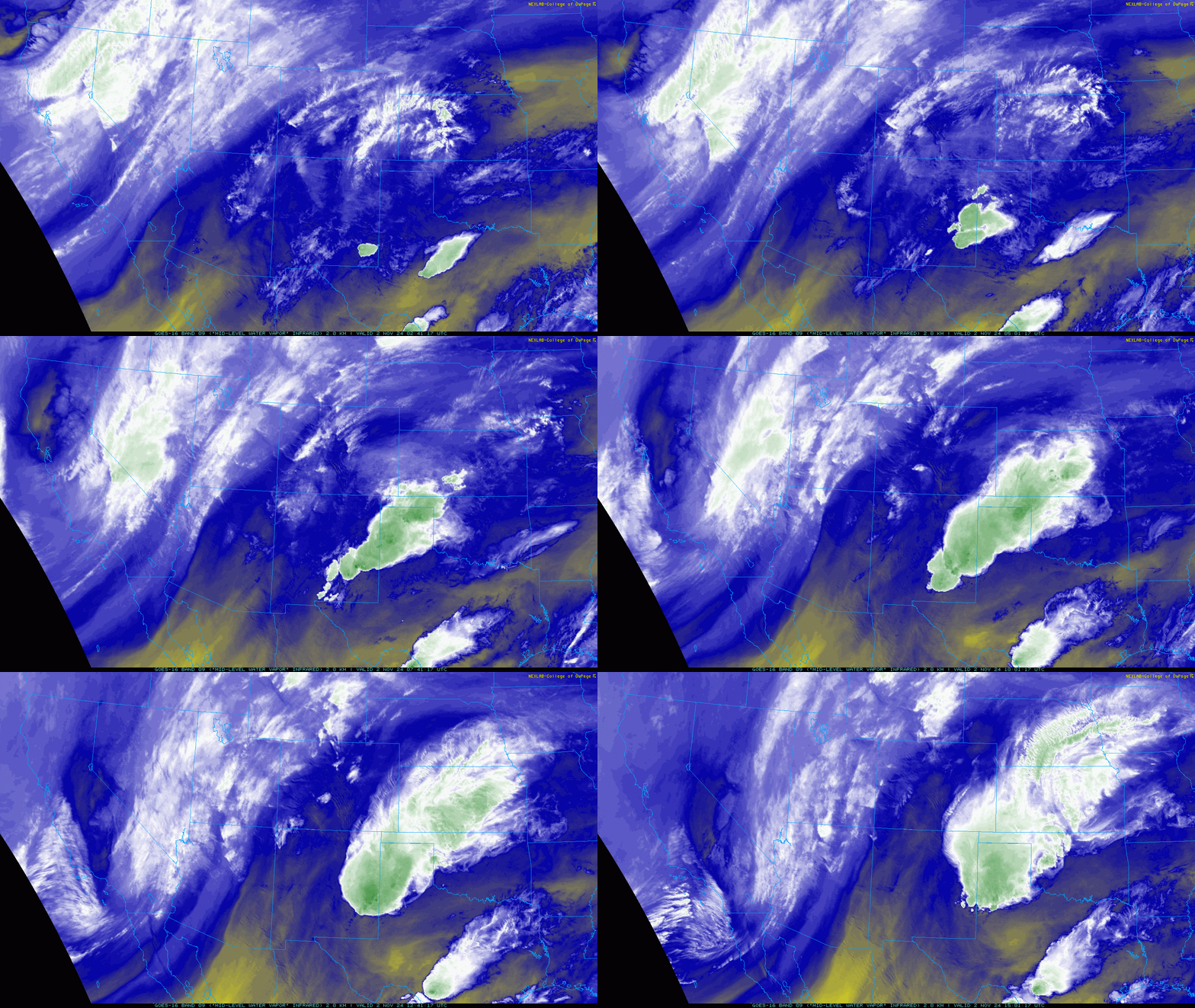
Water vapor satellite loop valid from 9:41 pm on Friday to 10:01 am on Saturday (1-2 November 2024). |
|
| The initial round of thunderstorms that kicked off the active stretch started in eastern New Mexico Friday evening (1 November). Lift from an approaching mid-level disturbance sparked rapid thunderstorm development as it overspread the moist and unstable air spreading back into eastern New Mexico. Several of these storms became strong to severe early-on, while torrential rain led to areas of flash flooding. | |
 |
|
| Flooded roadway near Indiana Avenue and 98th Street, in south Lubbock, late Saturday morning (2 November 2024). The image is courtesy of Kaitlin Schueth. | |
| The thunderstorm activity in eastern New Mexico quickly expanded into a large complex as it spread into West Texas late Friday night into Saturday morning. One stronger segment embedded in the initial line of storms moving across the South Plains Saturday morning generated a wind gust as high as 68 mph as it moved by the West Texas Mesonet (WTM) site south of Olton. Another severe wind gust, peaking at 61 mph, was measured by the WTM site northeast of Shallowater as the line progressed eastward. However, much more widespread was the heavy rain that this activity provided to the region. Locations over the southwest Texas Panhandle, in and around Farwell, Bovina and Friona, recorded rain totals near and above 3 inches with the first round of thunderstorms early Saturday morning. Roads quickly became inundated and several vehicles flooded out. | |
 |
|
| Regional radar animation valid from 6:55 am to 11:15 pm on Saturday (2 November 2024). An animation of the Lubbock radar, valid from 10:18 am to 11:27 pm, can be VIEWED HERE. | |
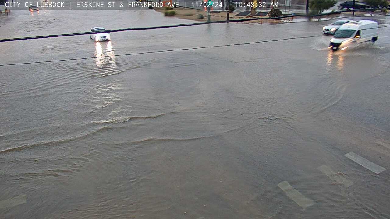
| The heavy rain advanced into the central South Plains mid-morning Saturday, bringing deluges to many spots, including in and around Lubbock. A quick 1 to 3 inches of rain produced widespread street flooding in Lubbock and quickly saturated the top soils that were mere minutes earlier bone dry. | |
 |
|
| Flooding near Erskine Street and Frankford Avenue in Lubbock Saturday morning (2 November 2024). The image is courtesy of the City of Lubbock. | |
| The advancing line of thunderstorms also brought rain-cooled air that caused the temperatures to tumble back into the lower and middle 50s, after starting out in the middle to upper 60s. The leading edge of the cooler air continued to spark additional showers and storms as it advanced southeastward through the day Saturday. | |
 |
|
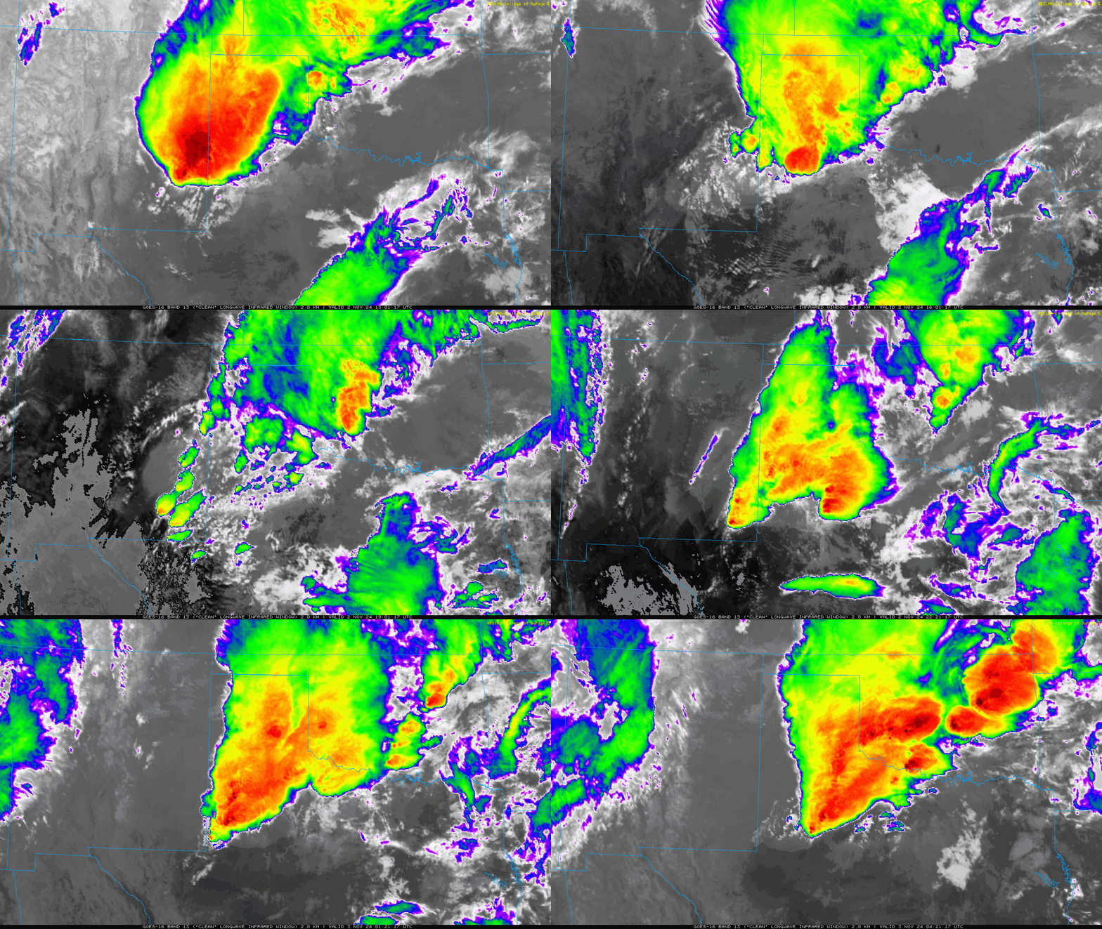
| Infrared satellite loop valid from 8:01 am to 11:21 pm on Saturday (2 November 2024). | |
| As temperatures warmed into the 70s and lower 80s south of the outflow boundary/cold front, a new round of robust thunderstorms formed over southeast New Mexico into the northern Permian Basin Saturday afternoon. Several of these storms became supercells, producing large hail, and one even generated a brief tornado west of Eunice. This activity weakened a bit as it moved over the much cooler air over the South and Rolling Plains Saturday evening/night, but it did bring more heavy rain to the region. | |
 |
|
| Lubbock WSR-88D radar animation valid from 11:01 pm Sunday to 1:54 pm on Monday (3-4 November 2024). An additional radar animation, valid from 5:24 pm on Sunday to 5:54 am on Monday (3-4 November), can be VIEWED HERE. | |
| After a bit of a lull for much of the area during the day Sunday, more showers and thunderstorms developed Sunday night as more lift spread over the region in advance of a large storm system approaching via the Desert Southwest. The most intense activity favored the eastern South Plains into the Rolling Plains, and occurred around and after midnight into early Monday morning. Several locations, including Post, experienced a brief bout of hail, while nearly everyone saw more rainfall. | |
 |
|
| Hail that fell in Post around 1 am Monday morning (4 November 2024). This picture is courtesy of Jeannette Miller via Jacob Riley. | |
| The heaviest rain shifted east of the region before daybreak Monday, though additional scattered showers, even a few rumbles of thunder, lingered through the day as the main upper level storm system emerged over the southern High Plains. | |
 |
|
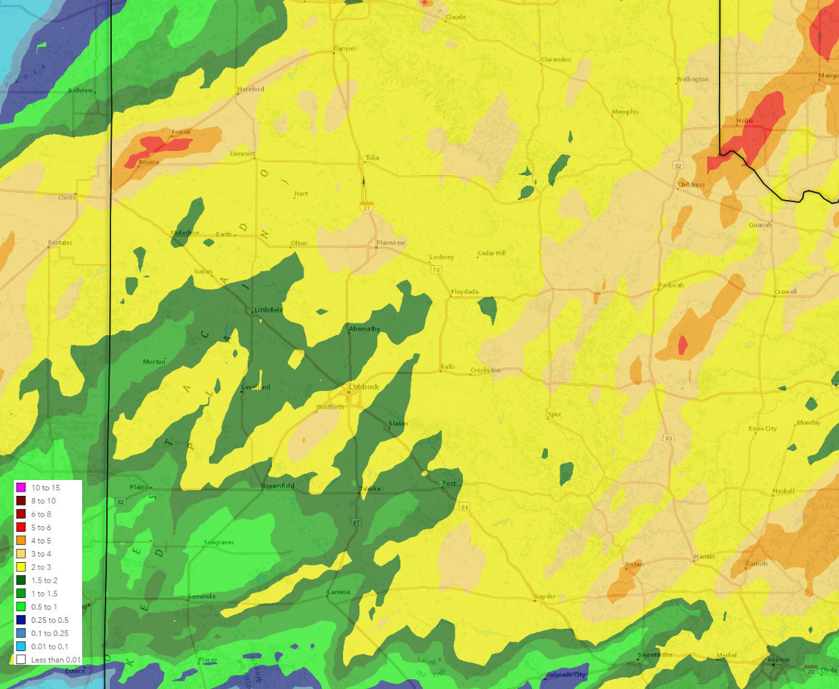
| Radar-estimated and bias-correct 5-day rainfall ending at 6 am on Monday (4 November 2024). A larger view, including much of Texas, can be FOUND HERE. | |
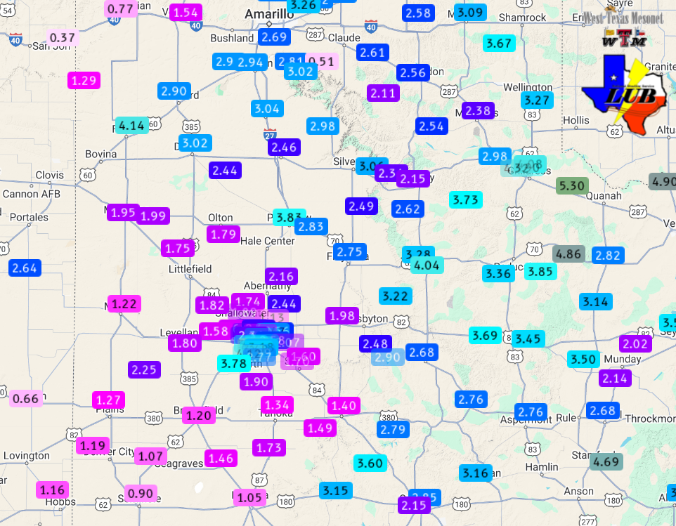
| By the time this early November weekend concluded the entire South Plains region recorded significant rain totals. Many spots measured 2 to 3+ inches of rain, with several swaths near and about 4 inches. The heaviest rains targeted the Highway 60 Corridor from Farwell to Friona, as well as the southeast Texas Panhandle into parts of the Rolling Plains, and the southwest side of Lubbock where totals from 3.50 to 4+ inches were common. | |
 |
|
| 5-day rain totals ending at 1 pm on Monday (4 November 2024). The data are courtesy of the West Texas Mesonet and National Weaver Service. A zoomed in view on the South Plains region can be VIEWED HERE. A close up on the Lubbock area can be FOUND HERE. | |
| Officially, the Lubbock Airport recorded 1.65 inches on November 2nd, a daily record for the date. Not to be outdone, Childress officially measured 3.03 inches on the 2nd, also setting a daily record. In addition, the rain totals at both Lubbock and Childress set new daily records for the month of November. | |
 |
|
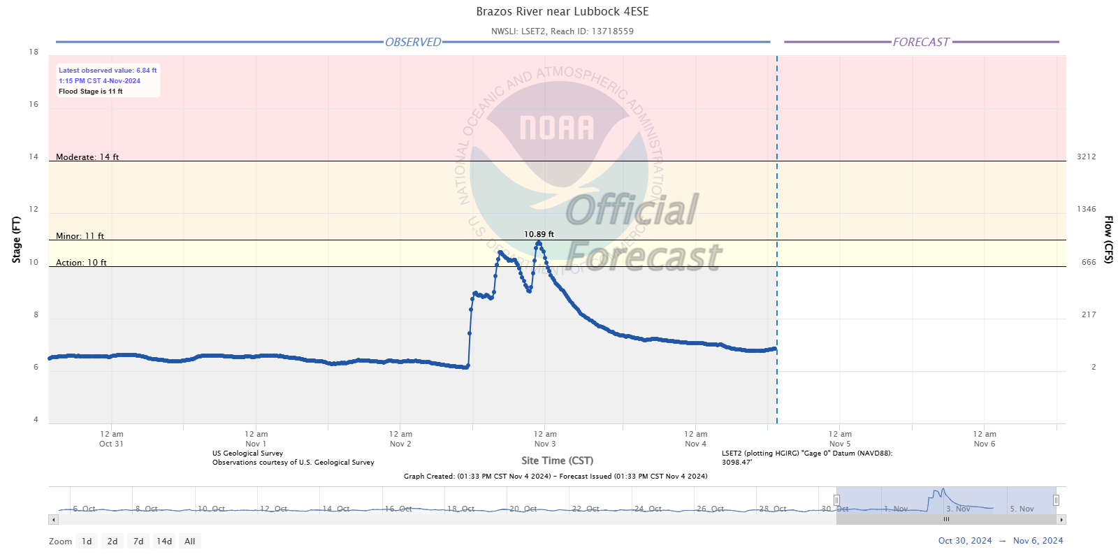
| River levels observed on the headwaters of the Brazos River on the southeast side of Lubbock in early November 2024. | |
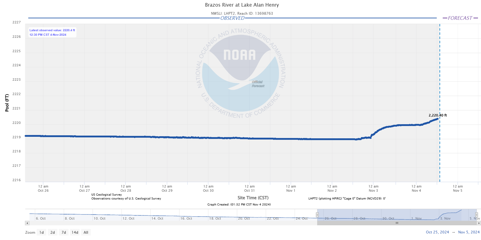
| Runoff from the heavy rain caused the mostly dry creeks/rivers of West Texas to flow again. The headwaters of the Brazos in Lubbock briefly rose to action stage. Farther south, water flowing through a different branch of the Brazos drained into Lake Alan Henry, causing it to rise approximately a foot and a half, back above its full capacity level (2020 feet). | |
 |
|
| Lake Alan Henry water levels measured in late October and early November 2024. | |
|
Storm reports for this active start to November can be found below: |
|
Preliminary Local Storm Report...Summary
National Weather Service Lubbock TX
442 AM CST Sun Nov 3 2024

..TIME...   ...EVENT...      ...CITY LOCATION...     ...LAT.LON...
..DATE...   ....MAG....      ..COUNTY LOCATION..ST.. ...SOURCE....
            ..REMARKS..

0324 AM     Flash Flood      Farwell                 34.39N 103.03W
11/02/2024                   Parmer             TX   Law Enforcement

            Water reported over several roadways in
            Farwell.

0428 AM     Flash Flood      1 SW Bovina             34.51N 102.91W
11/02/2024                   Parmer             TX   Law Enforcement

            Water reported to be over the roadway and
            increasing on Highway 60 near Bovina.

0735 AM     Flash Flood      Bovina                  34.51N 102.88W
11/02/2024                   Parmer             TX   Law Enforcement

            Several vehicles stranded in flood waters as
            of 733 AM.

0902 AM     Tstm Wnd Gst     6 SSW Anton             33.87N 102.12W
11/02/2024  M68 MPH          Lamb               TX   Mesonet

            Corrects previous tstm wnd gst report from 4
            SSE Spade.

0915 AM     Flash Flood      1 NNE Bovina            34.53N 102.88W
11/02/2024                   Parmer             TX   Public

            Report with photo of flooded Highway 60.

0932 AM     Tstm Wnd Gst     4 NNE Shallowater       33.74N 101.97W
11/02/2024  M61 MPH          Lubbock            TX   Mesonet


1056 AM     Flood            2 W Lubbock             33.59N 101.87W
11/02/2024                   Lubbock            TX   Public

            Reports of 3-4 inches of water at the
            intersection of University and Broadway.

1109 AM     Flood            5 NNW Woodrow           33.51N 101.89W
11/02/2024                   Lubbock            TX   NWS Employee

            Reported over 6 inches at the intersection
            of 98th and Indiana.

0100 PM     Flood            Lubbock                 33.58N 101.84W
11/02/2024                   Lubbock            TX   Public

            Picture from social media of a police
            cruiser stranded in high waters.

0814 PM     Hail             Meadow                  33.34N 102.20W
11/02/2024  M1.00 Inch       Terry              TX   Broadcast Media

            Viewer reported to local broadcast media.

0918 PM     Flash Flood      5 NNW Woodrow           33.51N 101.89W
11/02/2024                   Lubbock            TX   Public

            Several inches of flowing water observed
            over multiple intersections in South
            Lubbock.