|
Late summer brings the HEAT to West Texas, and not much else |
|||||||||||||||||||||||||||||||||||||||||||||||||||||||||||||||||||||||||||||||||||||||||||||||||||||||||||||||||||||||||||||||||||||||||||||||||||||||||||||||||||||||||||
 |
|||||||||||||||||||||||||||||||||||||||||||||||||||||||||||||||||||||||||||||||||||||||||||||||||||||||||||||||||||||||||||||||||||||||||||||||||||||||||||||||||||||||||||
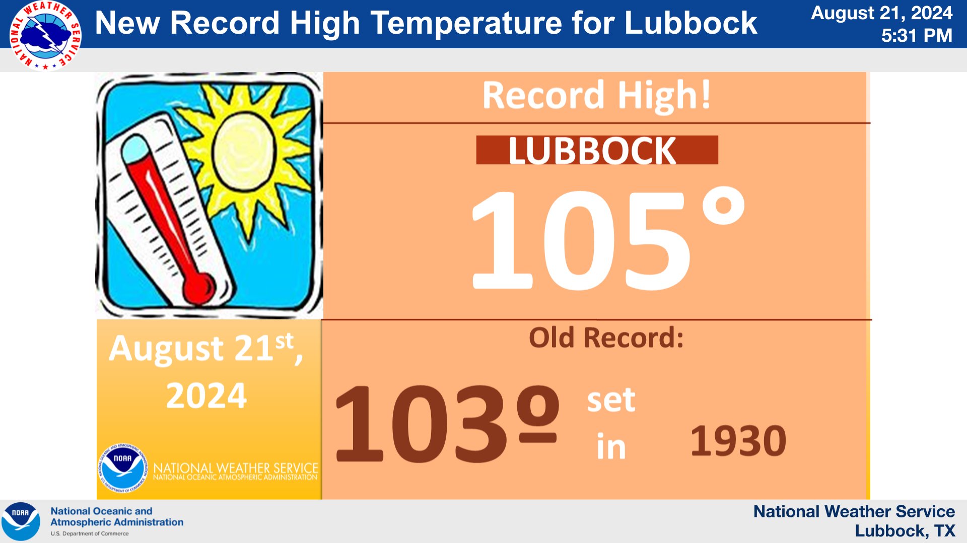
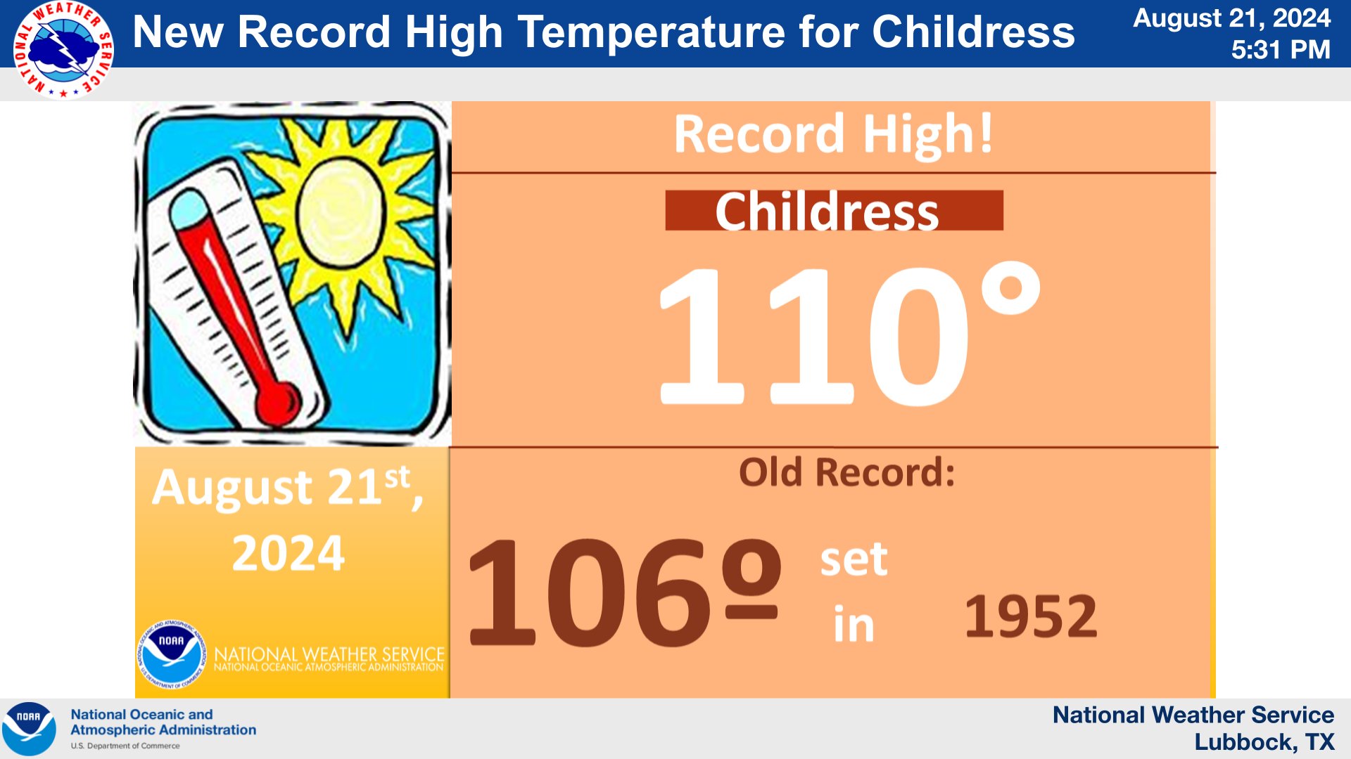
| Graphic showing the new record high achieved at Lubbock on Wednesday, August 21st. A similar graphic, but for Childress, can be FOUND HERE. | |||||||||||||||||||||||||||||||||||||||||||||||||||||||||||||||||||||||||||||||||||||||||||||||||||||||||||||||||||||||||||||||||||||||||||||||||||||||||||||||||||||||||||
|
The summer is supposed to be hot in Texas, but if you thought this August has been hotter than normal for West Texas, you'd be right. The first three days of August brought highs in the triple digits for Lubbock and Childress, as well as much of the South Plains, Rolling Plains and southern Texas Panhandle. The hot start to the month was not-so-subtle foreshadowing to what was to come. |
|||||||||||||||||||||||||||||||||||||||||||||||||||||||||||||||||||||||||||||||||||||||||||||||||||||||||||||||||||||||||||||||||||||||||||||||||||||||||||||||||||||||||||
 |
|||||||||||||||||||||||||||||||||||||||||||||||||||||||||||||||||||||||||||||||||||||||||||||||||||||||||||||||||||||||||||||||||||||||||||||||||||||||||||||||||||||||||||
|
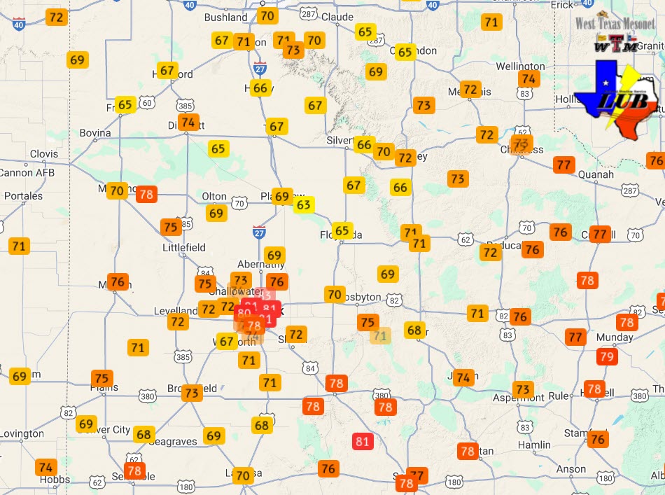
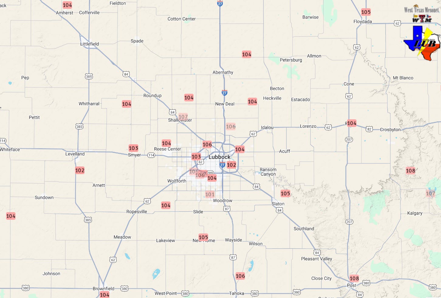
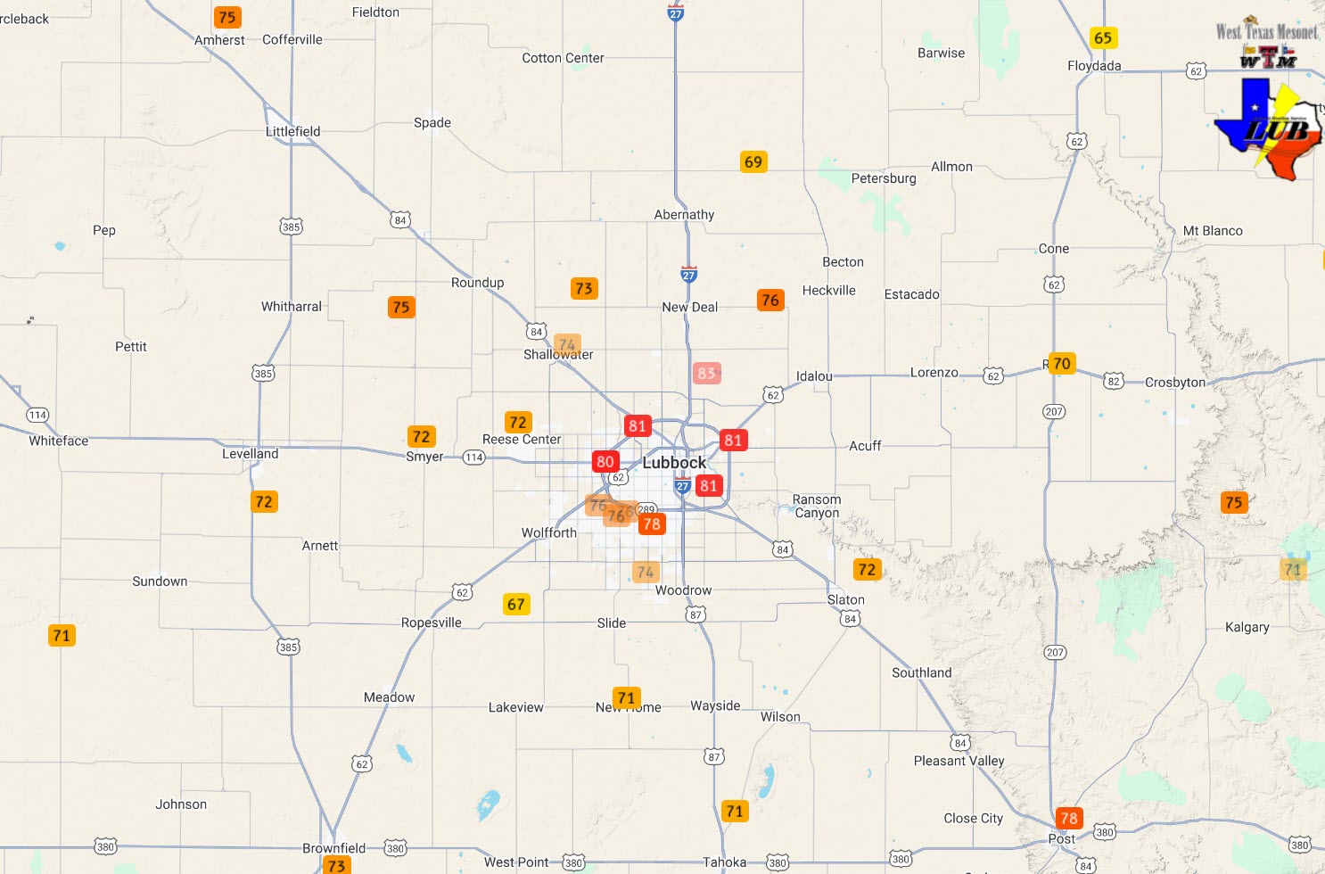
High temperatures observed around the South Plains region on 21 August 2024. A close up of the Lubbock area can be VIEWED HERE. The data are courtesy of the West Texas Mesonet (WTM) and the National Weather Service (NWS). |
|||||||||||||||||||||||||||||||||||||||||||||||||||||||||||||||||||||||||||||||||||||||||||||||||||||||||||||||||||||||||||||||||||||||||||||||||||||||||||||||||||||||||||
| Temperatures eased ever so slightly on August 4th, when most locations only warmed into the 90s. However, the "reprieve" was short-lived, with only one other noticeable "cool" period (on the 9th and 10th) between August 1st and the 24th. Instead, the intense and relentless heat was the main theme through most of August 2024. As the chart below shows, Lubbock officially reached the triple digits 16 times between August 1st and the 24th, with most of the other days topping out in the upper 90s. Childress was even hotter, reaching the triple digits all but 3 days through the first 25 days of the month. Thankfully, cooler weather finally returned to the region to conclude the month, with the final couple days of August experiencing below average highs. | |||||||||||||||||||||||||||||||||||||||||||||||||||||||||||||||||||||||||||||||||||||||||||||||||||||||||||||||||||||||||||||||||||||||||||||||||||||||||||||||||||||||||||
|
|||||||||||||||||||||||||||||||||||||||||||||||||||||||||||||||||||||||||||||||||||||||||||||||||||||||||||||||||||||||||||||||||||||||||||||||||||||||||||||||||||||||||||
| The heat of the first three plus weeks of the month wasn't confined to the daytime either, as hot/warm temperatures lingered well into the evening and overnight. Many locations, especially in towns and off the Caprock, failed to drop below the 70s by the next morning, while occasionally lows didn't drop below the 80 degree mark in spots. Thursday, August 22nd, brought one warm morning, particularly in Lubbock, where lows in town ranged from the middle 70s to lower 80s. The official low at the Lubbock Airport only reached 82 degrees, shattering the previous daily warm low record (75 degrees, set in 1985), and setting a new latest date in the year to record an 80+ degree low (previously 80 degrees, set on August 14, 2020). | |||||||||||||||||||||||||||||||||||||||||||||||||||||||||||||||||||||||||||||||||||||||||||||||||||||||||||||||||||||||||||||||||||||||||||||||||||||||||||||||||||||||||||
 |
|||||||||||||||||||||||||||||||||||||||||||||||||||||||||||||||||||||||||||||||||||||||||||||||||||||||||||||||||||||||||||||||||||||||||||||||||||||||||||||||||||||||||||
| Low temperatures observed around the South Plains region on 22 August 2024. A close up of the Lubbock area can be VIEWED HERE. The data are courtesy of the West Texas Mesonet (WTM) and the National Weather Service (NWS). | |||||||||||||||||||||||||||||||||||||||||||||||||||||||||||||||||||||||||||||||||||||||||||||||||||||||||||||||||||||||||||||||||||||||||||||||||||||||||||||||||||||||||||
| The very hot days, toasty evenings and warm nights further increased the risk for heat-related illnesses including heat exhaustion and heat stroke. Altogether, the first 24 days of August in Lubbock officially tied 2023 as the hottest, with regard to high temperatures, averaging 100.6 degrees. This same period had the warmest overnight low temperatures, averaging 73.6 degrees (besting 2023's average of 73.1 degrees). Despite the cooler end of the month, August still finished a whopping 5.2 degrees above normal in Lubbock, with a monthly average of 85.1 degrees, which ranked as the third hottest August on record (behind 2011 [86.0 degrees] and 2023 [85.5 degrees]). Even though records at Lubbock go back to 1911, 7 of the 10 hottest Augusts on record in Lubbock have been recorded since 2002, with the top 5 all occurring since 2011! | |||||||||||||||||||||||||||||||||||||||||||||||||||||||||||||||||||||||||||||||||||||||||||||||||||||||||||||||||||||||||||||||||||||||||||||||||||||||||||||||||||||||||||
|
|||||||||||||||||||||||||||||||||||||||||||||||||||||||||||||||||||||||||||||||||||||||||||||||||||||||||||||||||||||||||||||||||||||||||||||||||||||||||||||||||||||||||||
| Although very hot for August, the entire summer fell well short of the all-time records (thankfully!), as indicated by the total number of 100-degree days shown in the chart above. | |||||||||||||||||||||||||||||||||||||||||||||||||||||||||||||||||||||||||||||||||||||||||||||||||||||||||||||||||||||||||||||||||||||||||||||||||||||||||||||||||||||||||||
|
|||||||||||||||||||||||||||||||||||||||||||||||||||||||||||||||||||||||||||||||||||||||||||||||||||||||||||||||||||||||||||||||||||||||||||||||||||||||||||||||||||||||||||
| Lubbock recorded 10 straight 100-degree days during the middle portion of August, which tied for the 4th longest stretch on record. Only the summers of 2020, 1994 and 1980 experienced longer periods of consecutive triple digit days. Childress saw 15 straight 100-degree days in August 2024, which ranked as the 16th longest stretch, well shy of the record of 50 days from 2011. | |||||||||||||||||||||||||||||||||||||||||||||||||||||||||||||||||||||||||||||||||||||||||||||||||||||||||||||||||||||||||||||||||||||||||||||||||||||||||||||||||||||||||||
 |
|||||||||||||||||||||||||||||||||||||||||||||||||||||||||||||||||||||||||||||||||||||||||||||||||||||||||||||||||||||||||||||||||||||||||||||||||||||||||||||||||||||||||||
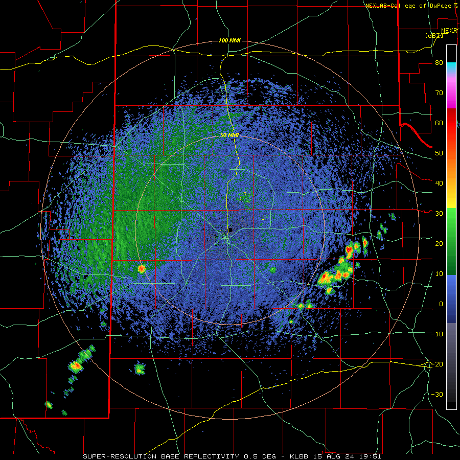
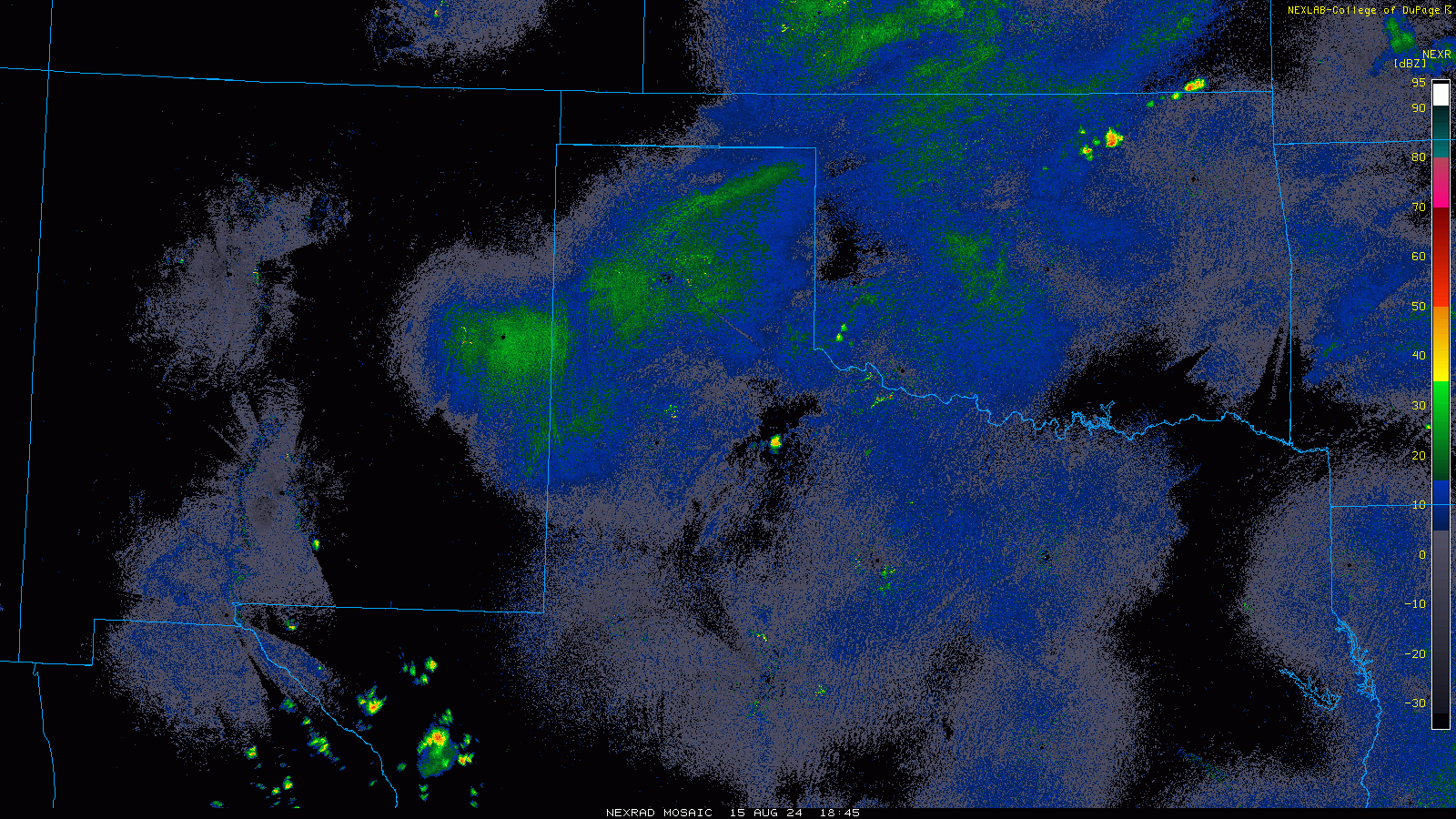
| Lubbock WSR-88D radar animation valid from 2:55 pm to 6:31 pm on Thursday (15 August 2024). | |||||||||||||||||||||||||||||||||||||||||||||||||||||||||||||||||||||||||||||||||||||||||||||||||||||||||||||||||||||||||||||||||||||||||||||||||||||||||||||||||||||||||||
| In addition to the heat, dry weather was the general rule through much of August. However, on a few occasions, the intense heat led to the development of isolated to widely scattered high-based thunderstorms. As is typical of thunderstorms when it is hot and relatively dry at and near ground level, the rainfall was spotty, and mostly light, but did occasionally produce pockets of heavier rain and intense downburst winds. In fact, Lubbock set a pair of records on August 8th when broke the record high (hitting 106 degrees, breaking the previous record of 105, set in 2003) and daily precipitation record (recording 1.32 inches of rain, breaking the previous record of 1.18 inches, set in 1949) for the day. | |||||||||||||||||||||||||||||||||||||||||||||||||||||||||||||||||||||||||||||||||||||||||||||||||||||||||||||||||||||||||||||||||||||||||||||||||||||||||||||||||||||||||||
 |
|||||||||||||||||||||||||||||||||||||||||||||||||||||||||||||||||||||||||||||||||||||||||||||||||||||||||||||||||||||||||||||||||||||||||||||||||||||||||||||||||||||||||||
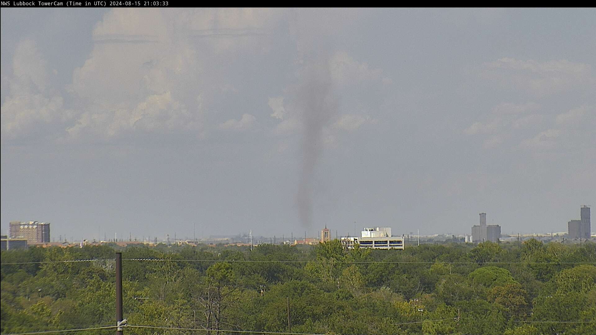
| Landspout tornado on the north side of Lubbock, as viewed from the south side of town at 4:03 pm on 15 August 2024. A zoomed out view, taken a minute later, can be FOUND HERE (Note: It is subtle, but the landspout can be seen on the left side of the image). | |||||||||||||||||||||||||||||||||||||||||||||||||||||||||||||||||||||||||||||||||||||||||||||||||||||||||||||||||||||||||||||||||||||||||||||||||||||||||||||||||||||||||||
| Mid-August brought a couple more rounds of isolated to scattered thunderstorms, though relatively limited rainfall. One developing storm produced a brief landspout tornado on the north side of Lubbock on August 15th, as can be seen above. As it typical with landspout-type tornadoes, it didn't last long and caused no known damage. | |||||||||||||||||||||||||||||||||||||||||||||||||||||||||||||||||||||||||||||||||||||||||||||||||||||||||||||||||||||||||||||||||||||||||||||||||||||||||||||||||||||||||||
 |
|||||||||||||||||||||||||||||||||||||||||||||||||||||||||||||||||||||||||||||||||||||||||||||||||||||||||||||||||||||||||||||||||||||||||||||||||||||||||||||||||||||||||||
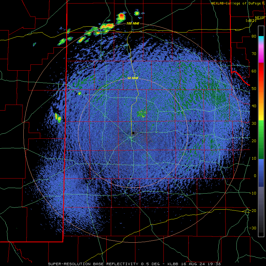
| Regional radar animation valid from 1:45 pm on Thursday (15 August 2024) to 4:05 am on Friday (16 August 2024). | |||||||||||||||||||||||||||||||||||||||||||||||||||||||||||||||||||||||||||||||||||||||||||||||||||||||||||||||||||||||||||||||||||||||||||||||||||||||||||||||||||||||||||
| A few other thunderstorms produced severe-caliber wind gusts Thursday afternoon and evening (15 August), including an impressive 90 mph gust measured by the West Texas Mesonet site near Flomot. On the plus side, the intense winds came with heavy rain, including a quick burst of 0.68 inches. | |||||||||||||||||||||||||||||||||||||||||||||||||||||||||||||||||||||||||||||||||||||||||||||||||||||||||||||||||||||||||||||||||||||||||||||||||||||||||||||||||||||||||||
 |
|||||||||||||||||||||||||||||||||||||||||||||||||||||||||||||||||||||||||||||||||||||||||||||||||||||||||||||||||||||||||||||||||||||||||||||||||||||||||||||||||||||||||||
| Lubbock WSR-88D radar animation valid from 2:38 pm to 6:37 pm on Friday (16 August 2024). | |||||||||||||||||||||||||||||||||||||||||||||||||||||||||||||||||||||||||||||||||||||||||||||||||||||||||||||||||||||||||||||||||||||||||||||||||||||||||||||||||||||||||||
|
The next afternoon and evening (16 August) brought additional thunderstorms, including a few severe wind gusts, that targeted the southern Texas Panhandle. A peak gust of 65 mph was measured by the West Texas Mesonet site near Happy as storms moved in from the north. Unfortunately, though, the spotty and generally light rainfall was no match for the intense and persistent heat of August and led to increasing drought concerns. The drying and curing of vegetation also supported several wildfires in the region, despite the generally lighter winds of summer (outside of in and near thunderstorms). Mid-August storm reports can be found below: |
|||||||||||||||||||||||||||||||||||||||||||||||||||||||||||||||||||||||||||||||||||||||||||||||||||||||||||||||||||||||||||||||||||||||||||||||||||||||||||||||||||||||||||
Preliminary Local Storm Report...Summary
National Weather Service Lubbock TX
505 AM CDT Fri Aug 16 2024

..TIME...   ...EVENT...      ...CITY LOCATION...     ...LAT.LON...
..DATE...   ....MAG....      ..COUNTY LOCATION..ST.. ...SOURCE....
            ..REMARKS..

0313 PM     Tstm Wnd Gst     10 WSW Guthrie          33.57N 100.48W
08/15/2024  M63 MPH          King               TX   Mesonet


0644 PM     Tstm Wnd Gst     2 E Flomot              34.23N 100.95W
08/15/2024  M90 MPH          Motley             TX   Mesonet


0754 PM     Tstm Wnd Gst     Smyer                   33.59N 102.16W
08/15/2024  M69 MPH          Hockley            TX   Mesonet

