|
Destructive wind and giant hail impact the South Plains |
|
 |
|
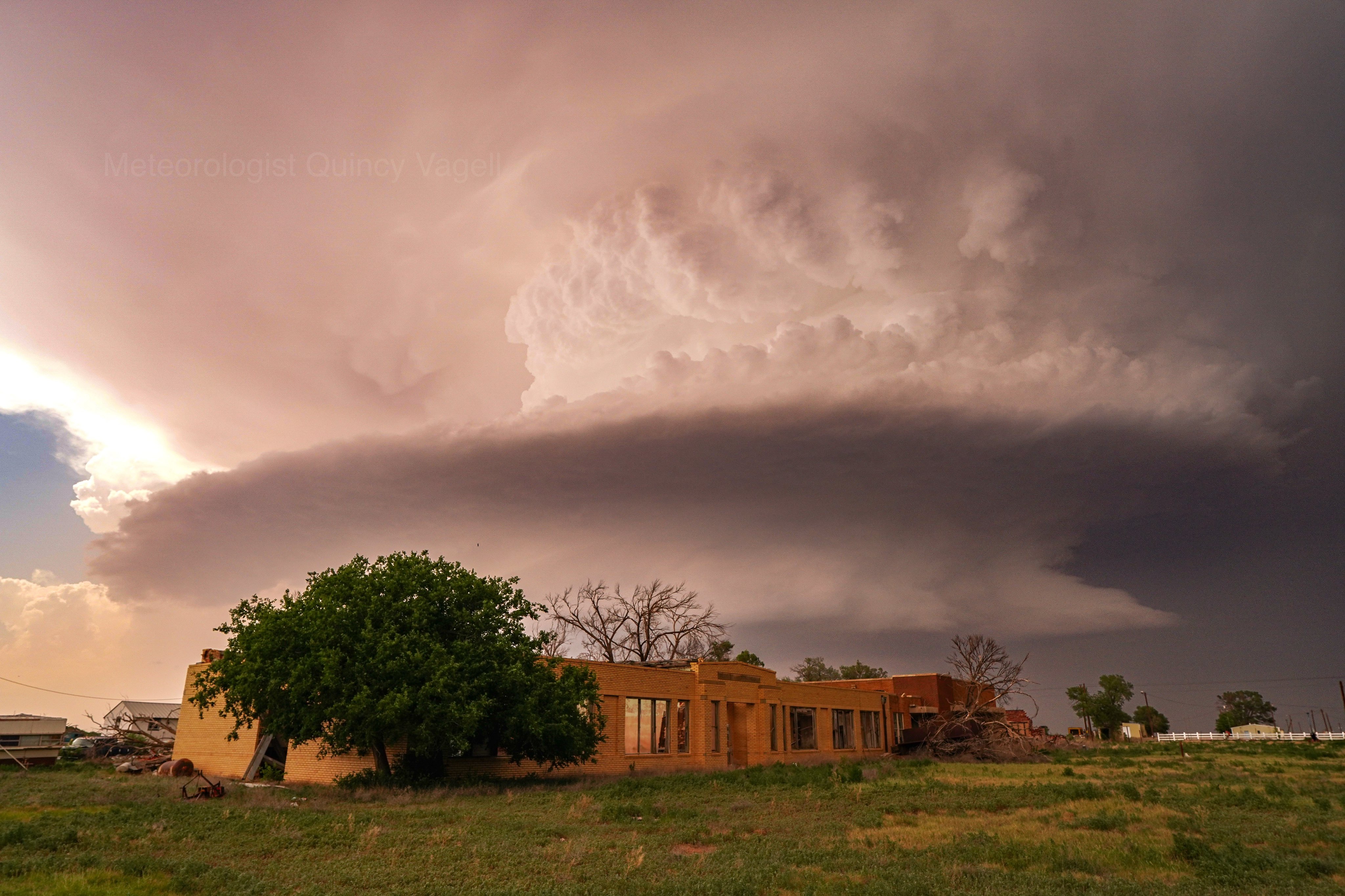
| Supercell thunderstorm near Pettit Tuesday evening (28 May 2024). The image is courtesy of Quincy Vagell. | |
|
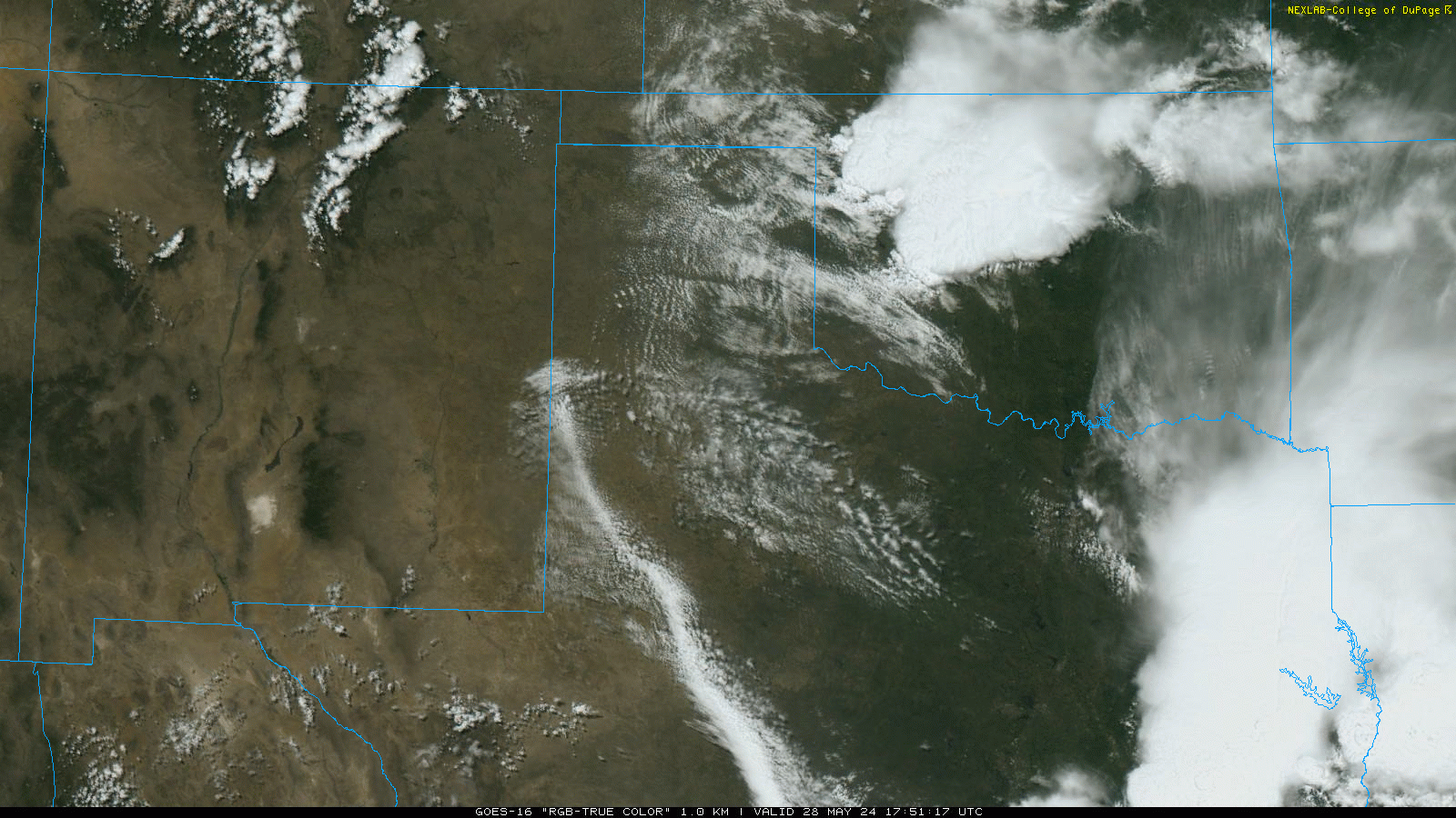
A dryline, in combination with a westward moving outflow boundary, served as a focus for thunderstorm development Tuesday afternoon (28 May). The initial activity formed over the western South Plains and southwest Texas Panhandle. Warm temperatures, in the 90s, combined with good low-level moisture, provided plenty of instability to fuel the thunderstorms. In addition, vertical wind shear was sufficient to support storm organization, and several of the thunderstorms did begin to rotate shortly after forming. |
|
 |
|
| RGB "True Color" satellite loop valid from 12:56 pm to 3:16 pm on Tuesday, 28 May 2024. | |
| Both right moving (cyclonic) and left moving (anticyclonic) supercells (rotating thunderstorms) unfolded over the western South Plains. The most intense storms produced hail, and in a few cases very large hail, along with torrential rain and strong to severe wind gusts. | |
 |
|
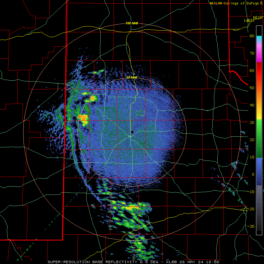
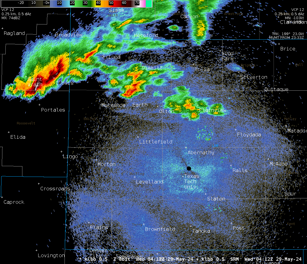
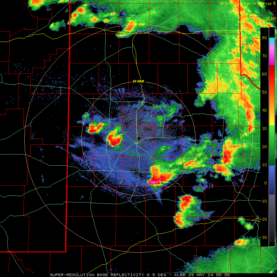
| Lubbock WSR-88D radar animation valid from 1:50 pm to 6:14 pm on Tuesday (28 May 2024). An additional radar animation, valid from 7:01 pm to 9:58 pm on Tuesday, can be VIEWED HERE. | |
| One particularly robust storm tossed giant hail over the west-central South Plains. Baseball to softball, and even DVD, sized hail was observed from a storm as it tracked slowly southeastward through Hockley County. | |
 |
|
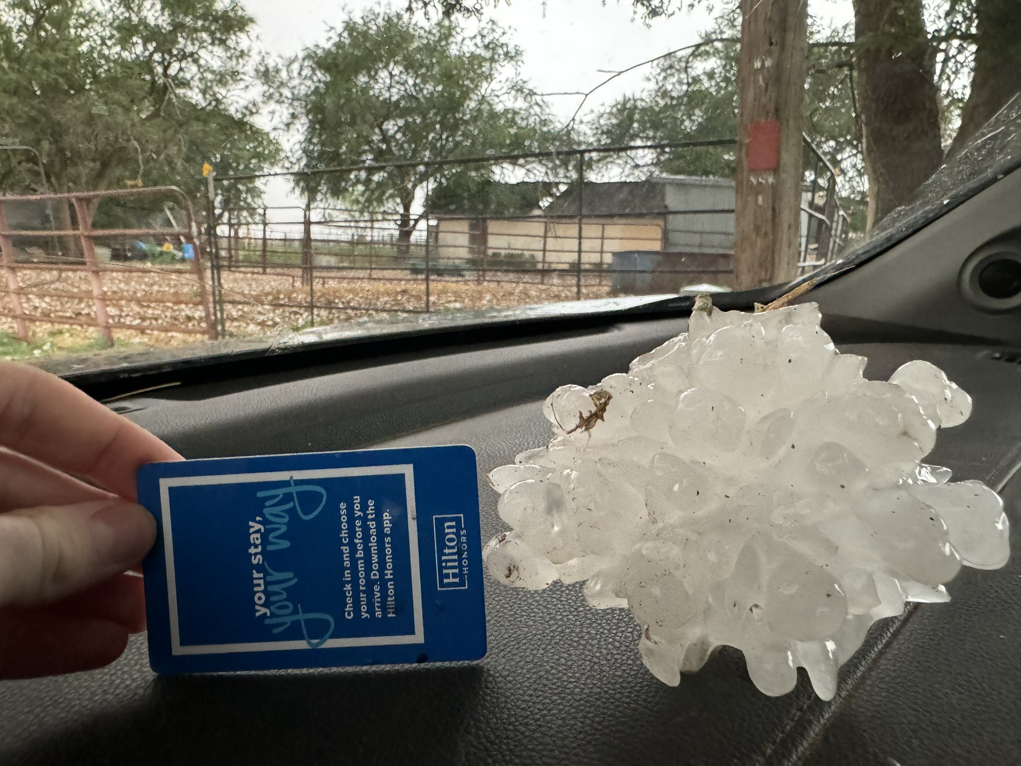
| Giant hail that fell northwest of Levelland Tuesday evening (28 May 2024). The picture is courtesy of Matthew Cappucci. | |
| The storm weakened modestly as it continued to move southeastward, but still dropped golf ball sized hail as it passed near Wolfforth Tuesday evening. | |
 |
|
| View of the giant hail-producing supercell thunderstorms as it moved to the southwest of Lubbock Tuesday evening. | |
| Even outside of the primary thunderstorm cores, strong and severe wind gusts occurred on the backside of a decaying rain area over the south-central Texas Panhandle. The West Texas Mesonet (WTM) site near Hart measured a peak gust of 71 mph at 5:07 pm, while the WTM site located on the south side of Plainview recorded a peak gust of 70 mph at 6:33 pm. The severe wind gusts did down several power poles in and around Plainview. Not to be outdone, the WTM near Aiken recorded a gust of 77 mph at 6:58 pm. | |
 |
|
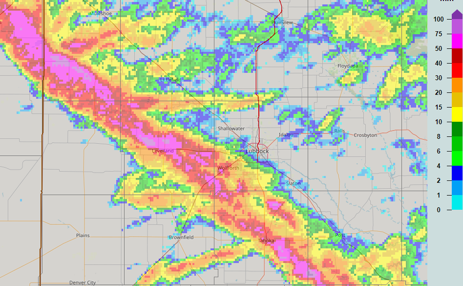
| 24-hour radar-estimated max hail size (in millimeters) ending at 7 am on Wednesday, 29 May 2024. | |
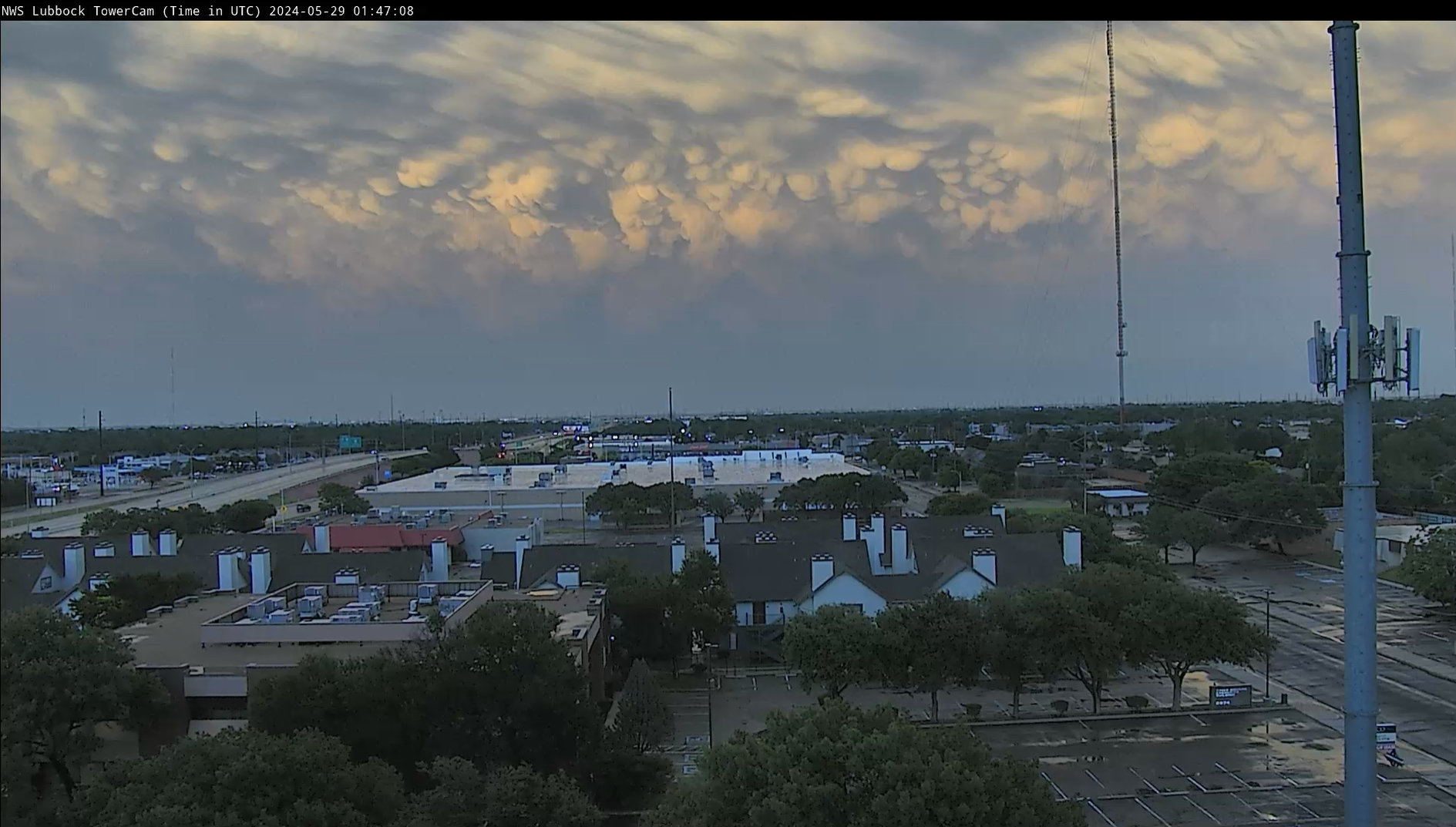
| The thunderstorm activity gradually faded over the South Plains during the mid-late evening hours after producing the pockets of giant hail and damaging winds. | |
 |
|
| Baseball size hail 12 miles southwest of Littlefield on Tuesday evening (28 May 2024). The picture is courtesy of Brandon Osterhout. | |
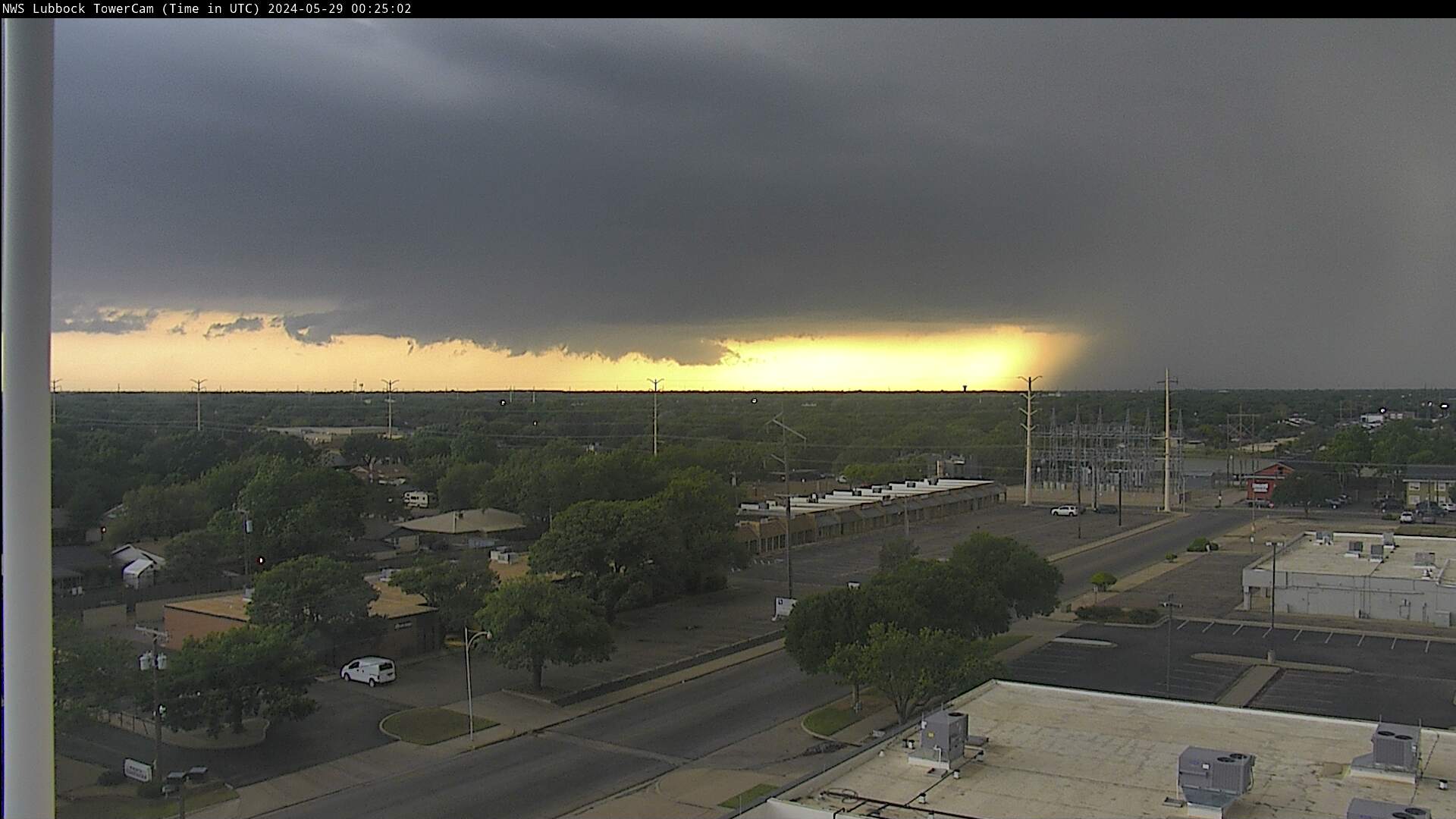
| In fact, those venturing outside Tuesday evening, at least in Lubbock, were treated to a fine ending to the day as the backside of the departing thunderstorms were illuminated by the setting sun. Generally, the saying goes that a red sky at night is a sailor's delight. However, this was not the case on this night as additional thunderstorm development over eastern New Mexico intensified and then tracked southeastward through the South Plains through early Wednesday morning, generating intense damaging winds, torrential downpours and wind-driven hail as it did so. | |
 |
|
| A beautiful end to the day as the backside of the departing (and weakening) thunderstorms were illuminated by the setting sun, as viewed from Lubbock, Thursday evening (28 May 2024). | |
| Specifically, a long-lived supercell thunderstorm developed near Tucumcari, New Mexico Tuesday evening and proceeded to move south and southeast overnight. As this storm entered western Bailey County in Texas around midnight CDT, it transitioned into a bow echo that continued to move southeast for the next four hours, accompanied by destructive winds, wind-driven hail and torrential rain. The storm finally weakened to below severe limits near Snyder around 4:30 AM CDT. | |
 |
|
| Infrared satellite loop valid from 2:01 pm on Tuesday to 6:11 am on Wednesday (28-29 May 2024). | |
|
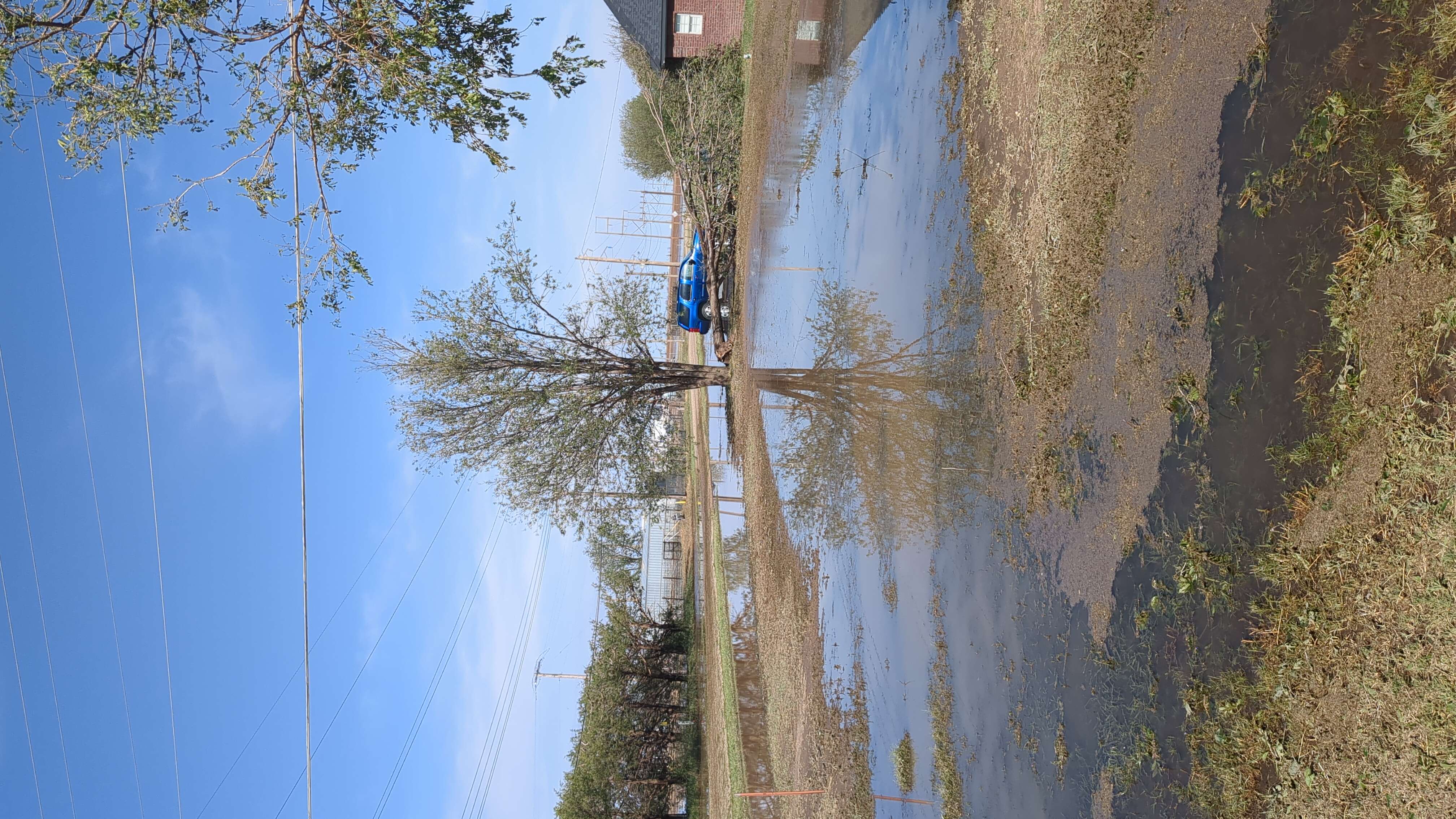
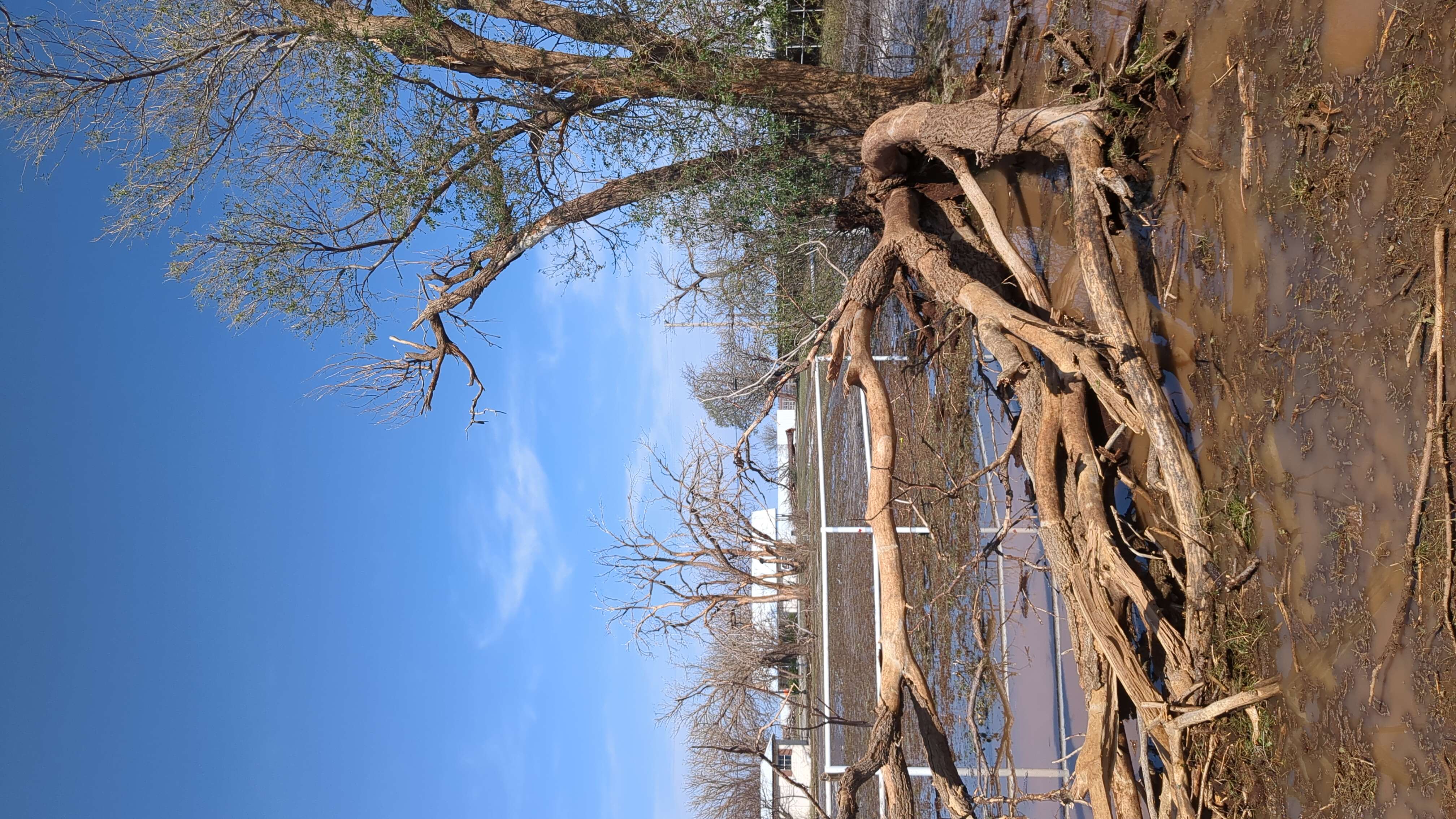
The most destructive straight-line winds occurred in Levelland from around 1:30 am until 1:40 am, with a second swath of intense winds impacting Tahoka shortly before 3 am. An NWS storm survey team documented extensive wind damage primarily on the north and east sides of Levelland, with additional damage also occurring in and around Tahoka. In addition to wind damage, a few homes in Levelland had floodwaters infiltrate the structures resulting in water damage with many more suffering rainwater damage from broken windows or damaged roofs. A total of eight people in Levelland received minor injuries from broken glass, but all were released from treatment. |
|
 |
|
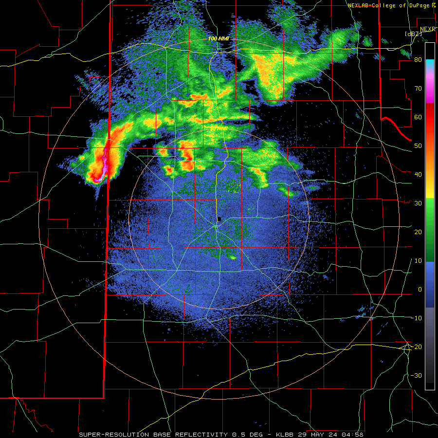
| Lubbock WSR-88D radar animation valid from 11:12 pm on Tuesday to 3:24 am on Wednesday (28-29 May 2024). An additional radar animation, valid from 11:58 pm on Tuesday to 6:21 am on Wednesday (28-29 May), can be VIEWED HERE. | |
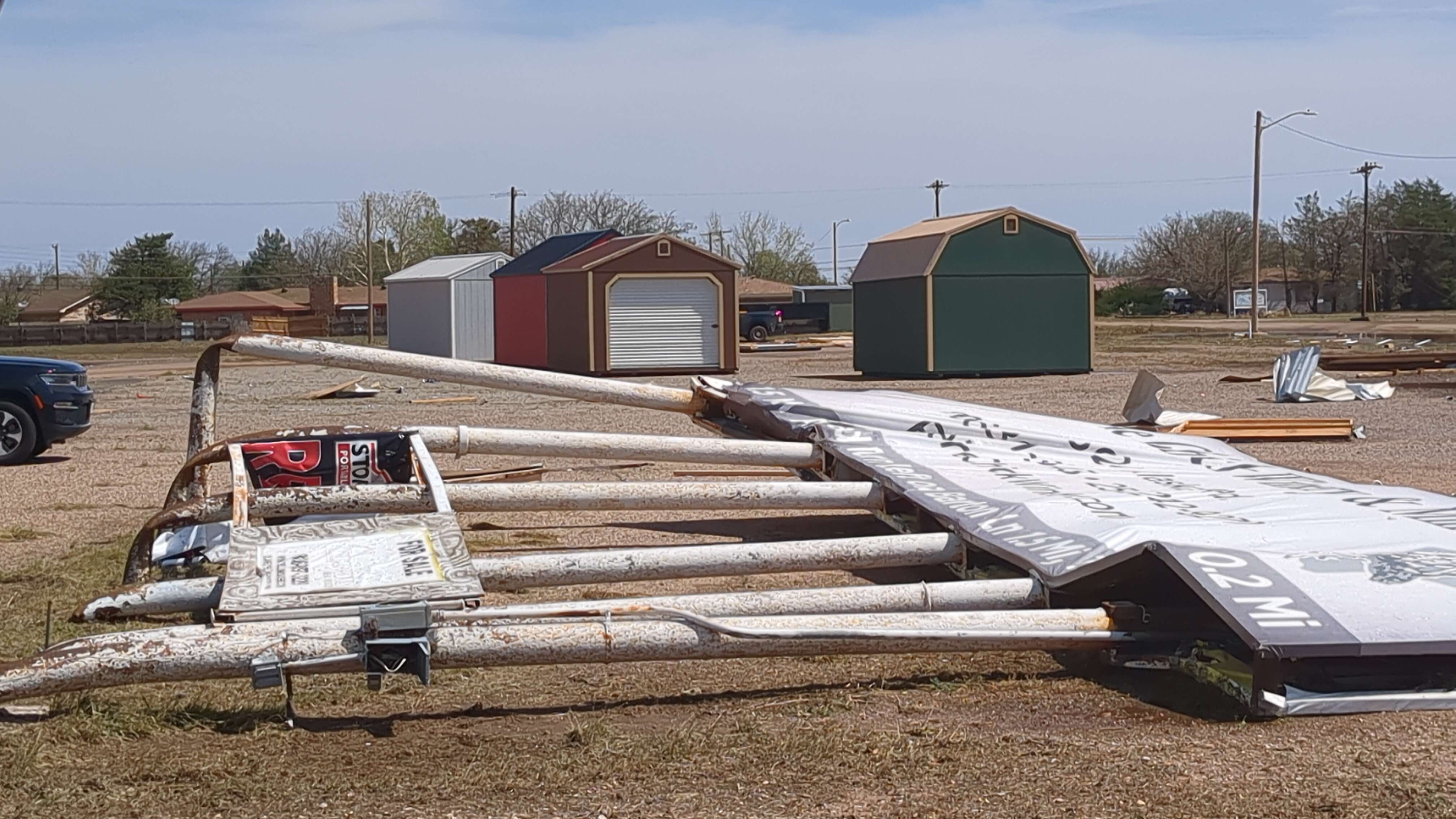
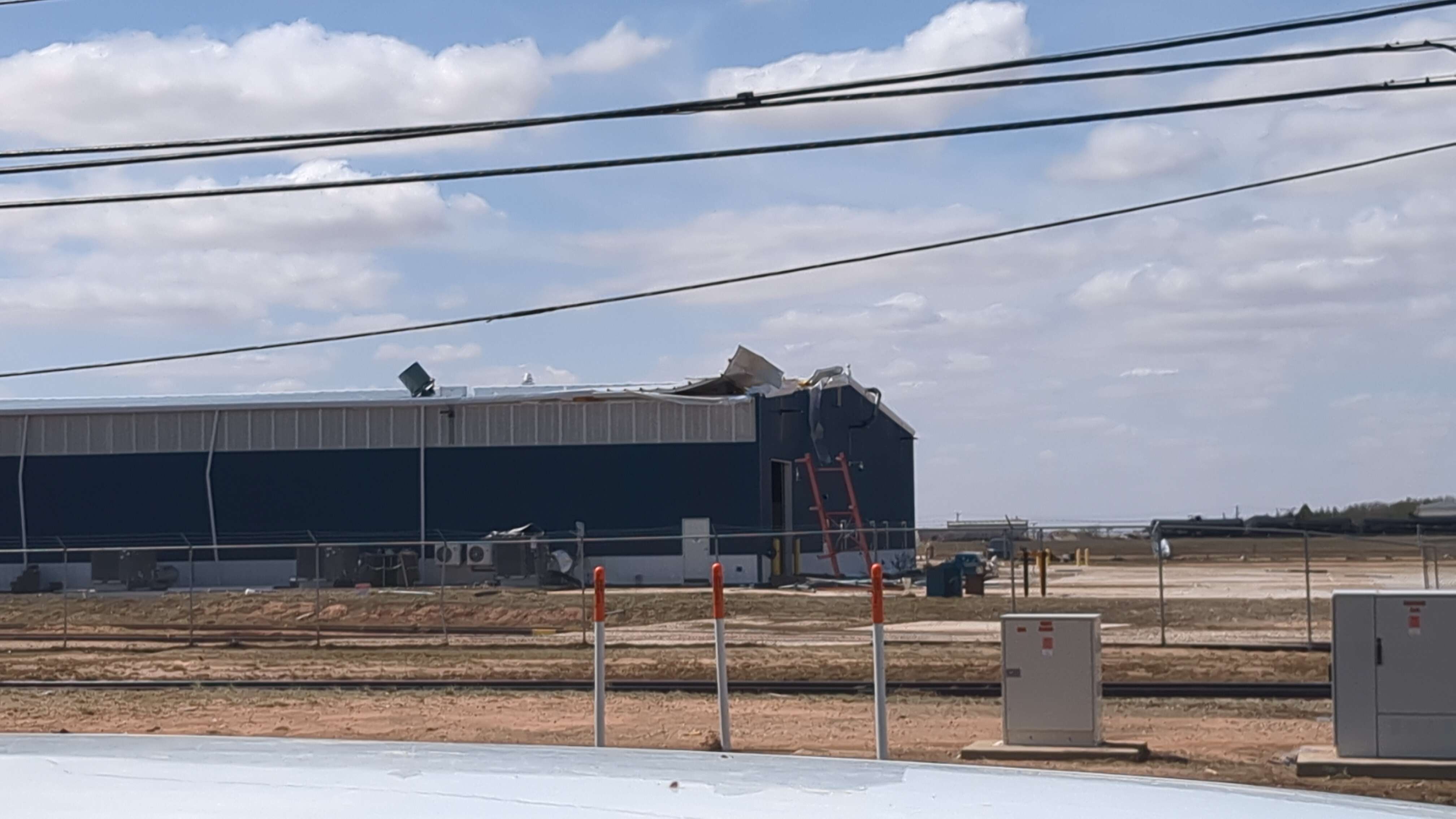
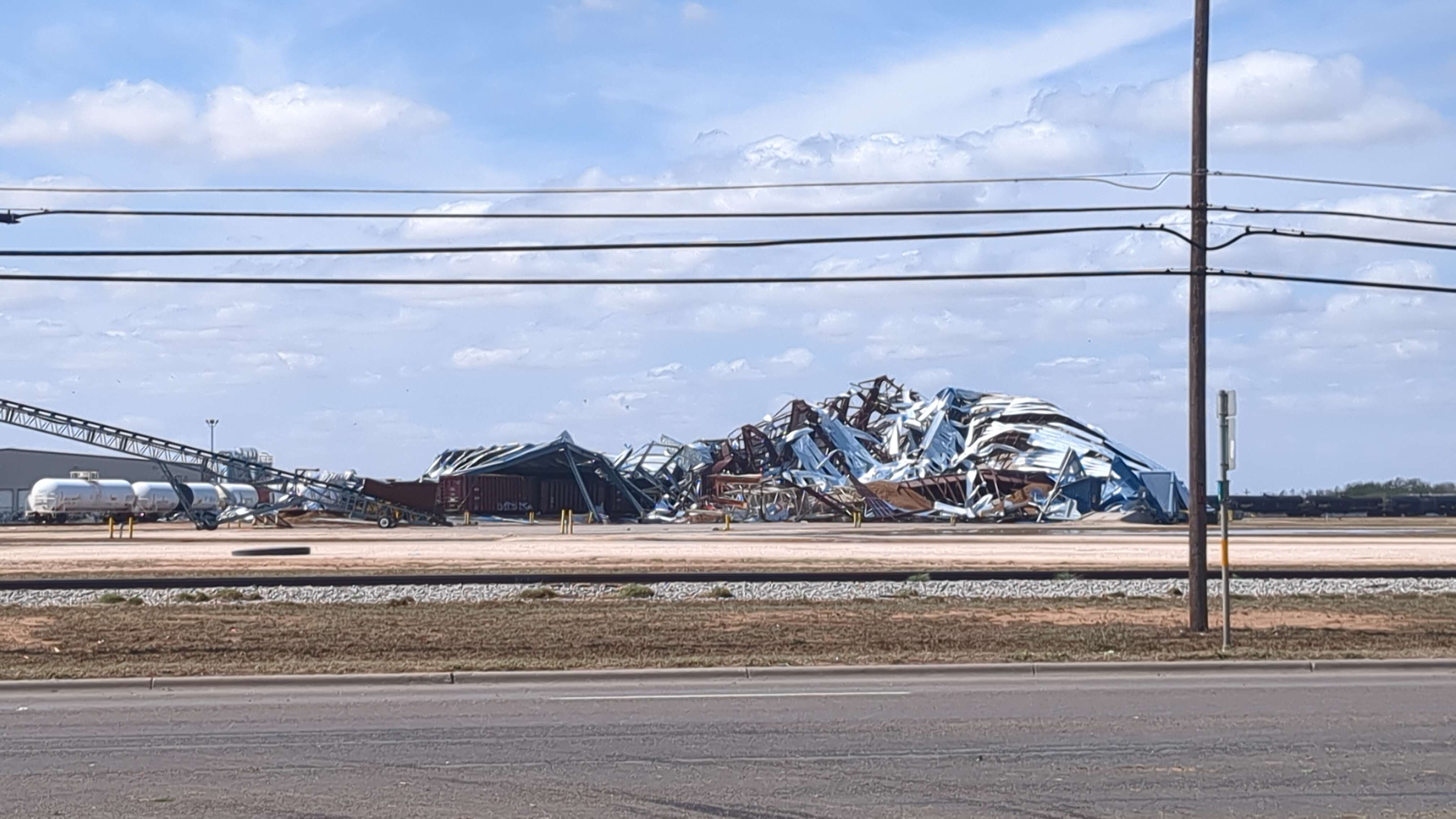
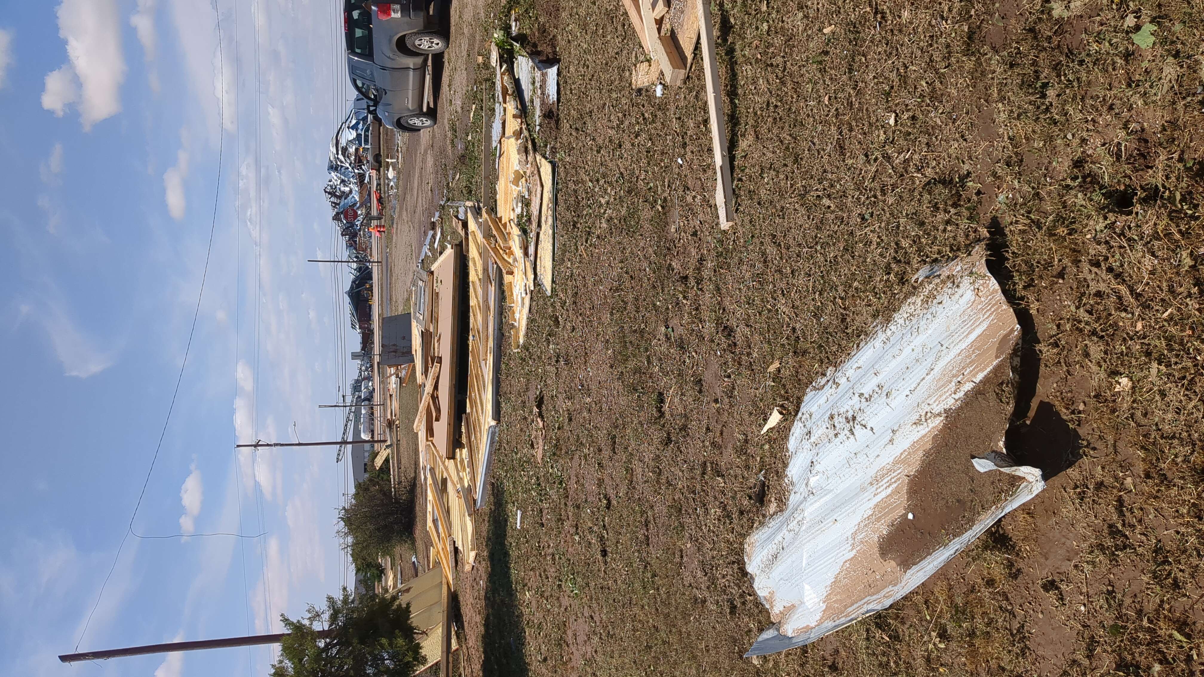
| The survey team began northwest of Levelland and observed damage to utility poles, trees and center pivots. Damage escalated in both coverage and intensity east of Highway 385 with a concentrated area of damage noted in and around Kauffman Park. Here, winds of 90 mph to 120 mph caused partial failures to some roofs and completely destroyed several wooden outbuildings. Many homes and vehicles suffered broken windows with roughly one dozen trees uprooted. One home lost roughly 30 percent of its roof and insulation while a wooden framed workshop in its backyard was completely destroyed and blown two homes away. Numerous wooden and metal fences were also heavily damaged or destroyed. The Penny Newman cotton gin on the east side of Levelland suffered total destruction from winds estimated around 110 mph. |
|
 |
 |
 |
|
 |
|
| Significant damage observed on the north and east side of Levelland. The pictures were taken by the NWS Lubbock Damage Survey Team Wednesday morning (29 May 2024). Damage ranged from sign and roof damage to the complete destruction of several sheds and buildings, including the Penny Newman Building in the picture immediately above. A kmz file with the damage survey results can be DOWNLOADED HERE. Alternatively, you can view the damage survey findings at: https://apps.dat.noaa.gov/StormDamage/DamageViewer/ | |
| As the storm progressed southeastward, the WTM northeast of Tahoka measured a 95 mph gust at 256 am. This gust coincided with the tip of the bow echo that continued to move southeast. The storm survey team observed 20 center pivots flipped over and damaged along with several newly installed power poles primarily on the north and east sides of Tahoka. In Tahoka, damage was relegated to some uprooted trees and numerous fallen tree limbs, with some minor structural damage noted to roofs and siding. No additional damage indicators were available beyond Highway 380 and County Road Y east of Tahoka | |
 |
 |
 |
 |
| Additional damage observed on the north and east side of Levelland. The pictures were taken by the NWS Lubbock Damage Survey Team Wednesday morning (29 May 2024). Damage ranged from sign and roof damage to the complete destruction of several sheds and buildings. A kmz file with the damage survey results can be DOWNLOADED HERE. Alternatively, you can view the damage survey findings at: https://apps.dat.noaa.gov/StormDamage/DamageViewer/ | |
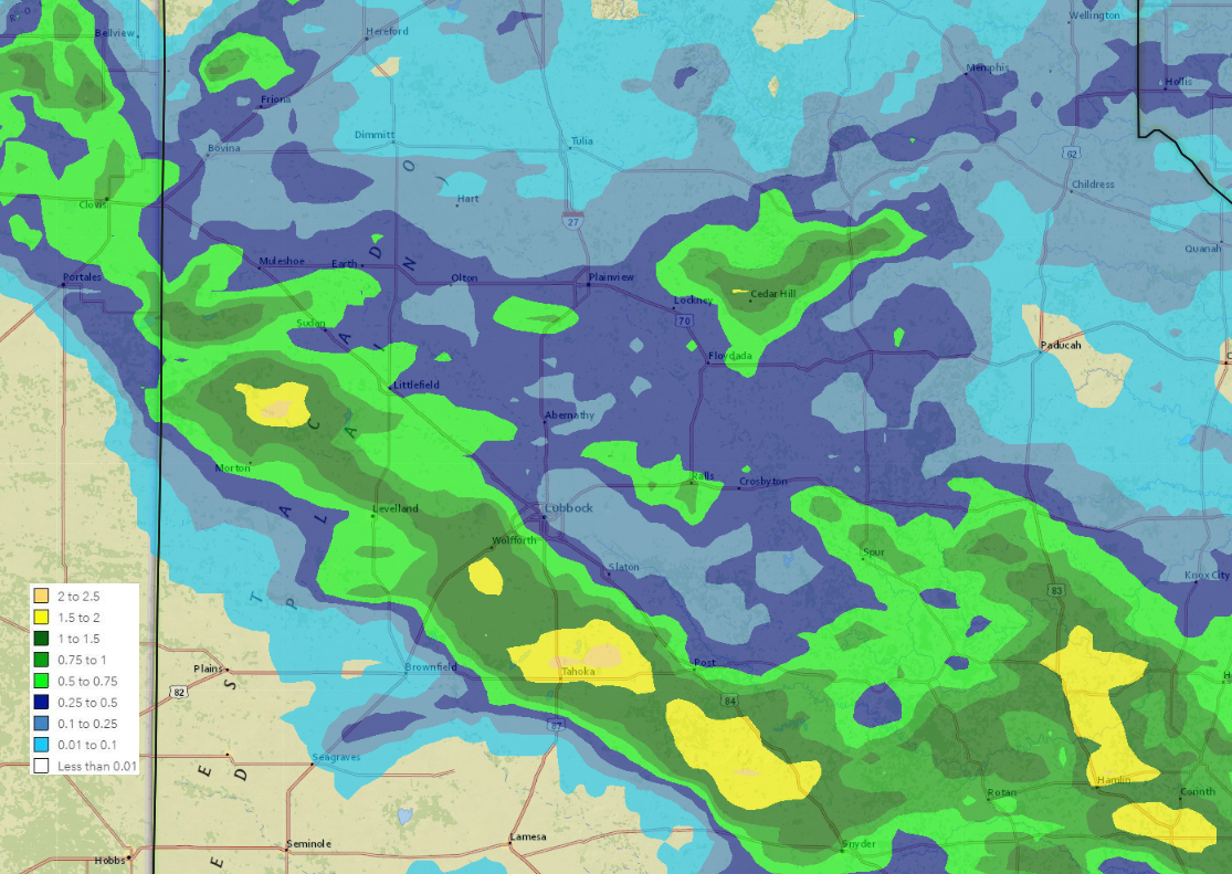
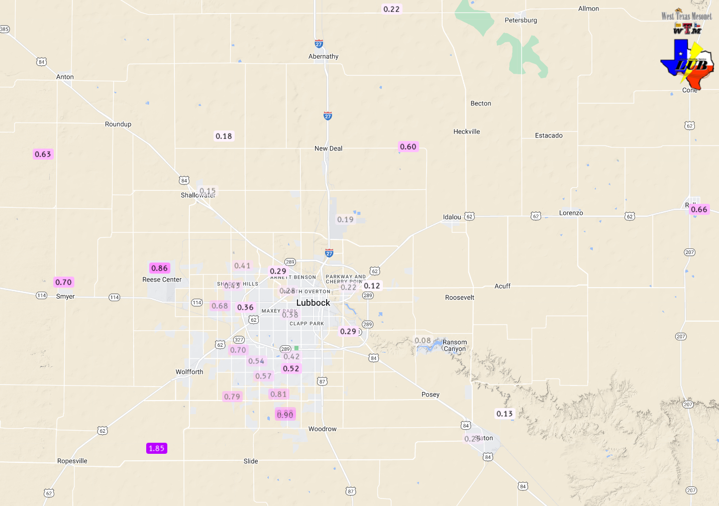
| In addition to the damaging wind and hail, heavy rain accompanied the thunderstorm activity. Many locations, outside of the southwest South Plains, recorded at least a little rainfall, while the heaviest rain fell in a swath paralleling, but just south of, Highway 84, where the most destructive overnight thunderstorm tracked. Rain totals of 1 to 2+ inches were common within the heaviest band, with the Tahoka WTM measuring 2.14 inches of rain to go along with the 95 mph wind gust. Another pocket of heavy rain, from 1 to 2 inches, also affected parts of Stonewall County, including Aspermont. | |
 |
|
| 24-hour radar-estimated and bias-corrected rainfall ending at 7 am on Monday, 20 May 2024. The rain measured by the West Texas Mesonet over this same period can be VIEWED HERE, with a closer look at the Lubbock area FOUND HERE. | |
|
Rain totals were lighter around Lubbock, varying from a half to three quarters of an inch on the southwest side of town to a tenth or two on the northeast side. Officially, the Lubbock Airport only measured 0.14 inches from this event, though it also missed out on the hail, while the southwest side of Lubbock received one or two rounds of small hail (generally at or below quarter size). Storm reports collected from this very active 12-hour stretch, from Tuesday afternoon to early Wednesday morning, can be found below: |
|
Preliminary Local Storm Report
National Weather Service Lubbock TX
1106 AM CDT Wed May 29 2024

..TIME...   ...EVENT...      ...CITY LOCATION...     ...LAT.LON...
..DATE...   ....MAG....      ..COUNTY LOCATION..ST.. ...SOURCE....
            ..REMARKS..

0225 PM     Hail             Wellman                 33.05N 102.43W
05/28/2024  E1.00 Inch       Terry              TX   Public

            Up to ten minutes of hail ranging from pea
            to quarter size at Southwest Cotton Growers.
            Began around 225 PM and ended at 235 PM.

0240 PM     Hail             7 NW Needmore           34.10N 102.83W
05/28/2024  E2.50 Inch       Bailey             TX   Storm Chaser

            Corrects time from previous report. At
            intersection of 2487 and 1154. Video shared
            on social media.

0257 PM     Hail             9 NW Needmore           34.12N 102.86W
05/28/2024  E1.75 Inch       Bailey             TX   Storm Chaser

            Video shared via social media.

0259 PM     Hail             7 NW Needmore           34.10N 102.83W
05/28/2024  E2.50 Inch       Bailey             TX   Storm Chaser

            At intersection of 2487 and 1154. Video
            shared on social media.

0307 PM     Hail             7 N Pep                 33.91N 102.58W
05/28/2024  E0.50 Inch       Lamb               TX   Public

            Report from mPING: Half-inch (0.50 in.).

0337 PM     Hail             1 E Levelland           33.58N 102.35W
05/28/2024  E0.25 Inch       Hockley            TX   Emergency Mngr


0339 PM     Hail             1 WSW Friona            34.63N 102.74W
05/28/2024  E1.50 Inch       Parmer             TX   Storm Chaser


0354 PM     Hail             5 E Amherst             34.03N 102.33W
05/28/2024  E0.75 Inch       Lamb               TX   Storm Chaser


0358 PM     Hail             1.5 S Enochs            33.84N 102.76W
05/28/2024  E1.25 Inch       Bailey             TX   Public

            Report from mPING: Half Dollar (1.25 in.).

0403 PM     Hail             3 S Sundown             33.41N 102.49W
05/28/2024  E1.25 Inch       Hockley            TX   Storm Chaser


0406 PM     Hail             1 S Enochs              33.86N 102.76W
05/28/2024  E2.00 Inch       Bailey             TX   Storm Chaser


0407 PM     Hail             2 S Enochs              33.85N 102.76W
05/28/2024  E1.75 Inch       Bailey             TX   Public

            Report from mPING: Golf Ball (1.75 in.).

0423 PM     Hail             Pep                     33.82N 102.56W
05/28/2024  M1.75 Inch       Hockley            TX   Storm Chaser


0432 PM     Hail             6 N Friona              34.73N 102.73W
05/28/2024  E0.88 Inch       Parmer             TX   Storm Chaser


0433 PM     Hail             1 S Pep                 33.80N 102.56W
05/28/2024  E0.50 Inch       Hockley            TX   Public

            Report from mPING: Half-inch (0.50 in.).

0436 PM     Hail             2 S Pep                 33.79N 102.56W
05/28/2024  E0.75 Inch       Hockley            TX   Public

            Report from mPING: Dime (0.75 in.).

0443 PM     Hail             2 S Pep                 33.78N 102.56W
05/28/2024  E0.75 Inch       Hockley            TX   Public

            Report from mPING: Dime (0.75 in.).

0456 PM     Hail             2 SE Pep                33.80N 102.54W
05/28/2024  E2.00 Inch       Hockley            TX   Public

            Report from mPING: Hen Egg (2.00 in.).

0457 PM     Hail             4 ESE Pep               33.79N 102.50W
05/28/2024  E3.00 Inch       Hockley            TX   Storm Chaser


0507 PM     Non-Tstm Wnd Gst 3 N Hart                34.42N 102.11W
05/28/2024  M71 MPH          Castro             TX   Mesonet

            Corrects previous non-tstm wnd gst report
            time from 3 N Hart. Severe wind gusts
            occurred from 5:02 pm to 5:07 pm, with the
            peak gust at 5:07 pm. Measured by the TTU
            mesonet.

0510 PM     Hail             4 E Meadow              33.33N 102.14W
05/28/2024  E2.75 Inch       Terry              TX   Storm Chaser


0512 PM     Hail             3 E Meadow              33.33N 102.15W
05/28/2024  E1.75 Inch       Terry              TX   Public

            Report from mPING: Golf Ball (1.75 in.).

0525 PM     Hail             4 N Whitharral          33.80N 102.33W
05/28/2024  E1.75 Inch       Hockley            TX   Storm Chaser


0526 PM     Hail             6 WSW New Home          33.30N 102.02W
05/28/2024  E1.25 Inch       Lynn               TX   Storm Chaser


0551 PM     Hail             Anton                   33.81N 102.16W
05/28/2024  E1.00 Inch       Hockley            TX   Public


0556 PM     Hail             6 S Pep                 33.74N 102.53W
05/28/2024  E2.75 Inch       Hockley            TX   Public

            Report from mPING: Baseball (2.75 in.).

0602 PM     Hail             2 SE Pep                33.79N 102.54W
05/28/2024  E1.00 Inch       Hockley            TX   Public

            Report from mPING: Quarter (1.00 in.).

0603 PM     Hail             8 NE Whiteface          33.69N 102.52W
05/28/2024  E3.25 Inch       Hockley            TX   Public

            Report from mPING: Baseball+ (3.25 in.).

0605 PM     Hail             8 NE Whiteface          33.69N 102.52W
05/28/2024  E3.00 Inch       Hockley            TX   Public

            Report from mPING: Tea Cup (3.00 in.).

0606 PM     Hail             1 WNW Tahoka            33.17N 101.81W
05/28/2024  E1.75 Inch       Lynn               TX   CO-OP Observer


0609 PM     Hail             3 W Tahoka              33.17N 101.85W
05/28/2024  E1.00 Inch       Lynn               TX   Public

            Report from mPING: Quarter (1.00 in.).

0614 PM     Hail             6 SSE Pep               33.73N 102.53W
05/28/2024  E4.50 Inch       Hockley            TX   Storm Chaser


0620 PM     Hail             1 N Tahoka              33.18N 101.80W
05/28/2024  E1.00 Inch       Lynn               TX   Public

            Report from mPING: Quarter (1.00 in.).

0621 PM     Non-Tstm Wnd Dmg Plainview               34.19N 101.72W
05/28/2024                   Hale               TX   Public

            Downed electric line poles in Plainview
            Texas.

0625 PM     Hail             7 NE Whiteface          33.68N 102.52W
05/28/2024  E5.00 Inch       Hockley            TX   Storm Chaser


0628 PM     Hail             5 E Whiteface           33.62N 102.53W
05/28/2024  E1.00 Inch       Hockley            TX   Public

            Report from mPING: Quarter (1.00 in.).

0630 PM     Non-Tstm Wnd Gst 6 S Olton               34.09N 102.12W
05/28/2024  M80 MPH          Lamb               TX   Mesonet

            Measured by the TTU mesonet.

0633 PM     Hail             5 W Levelland           33.60N 102.44W
05/28/2024  E3.25 Inch       Hockley            TX   Public

            Report from mPING: Baseball+ (3.25 in.).

0633 PM     Non-Tstm Wnd Gst 1 S Plainview           34.18N 101.72W
05/28/2024  M70 MPH          Hale               TX   Mesonet

            Corrects previous non-tstm wnd gst report
            time for 1 S Plainview. Severe wind gusts
            occurred, off and on, between 6:21 pm and
            7:20 pm. Measured by the TTU mesonet.

0639 PM     Hail             3 WNW Levelland         33.60N 102.41W
05/28/2024  E3.00 Inch       Hockley            TX   Storm Chaser


0644 PM     Hail             1 NNW Levelland         33.59N 102.37W
05/28/2024  E2.00 Inch       Hockley            TX   Public


0645 PM     Hail             3 N Morton              33.77N 102.76W
05/28/2024  E1.00 Inch       Cochran            TX   Public

            Report from mPING: Quarter (1.00 in.).

0657 PM     Hail             3 NE Morton             33.75N 102.73W
05/28/2024  E2.00 Inch       Cochran            TX   Public

            Report from mPING: Hen Egg (2.00 in.).

0658 PM     Non-Tstm Wnd Gst 3 WSW Aiken             34.13N 101.57W
05/28/2024  M77 MPH          Hale               TX   Mesonet

            Corrects previous non-tstm wnd gst report
            time from 3 WSW Aiken. Severe gusts were
            measured between 6:55 pm and 7:06 pm, with
            the peak gust occurring at 6:58 pm. Measured
            by the TTU mesonet.

0703 PM     Hail             3 NE Morton             33.75N 102.71W
05/28/2024  E2.75 Inch       Cochran            TX   Public

            Report from mPING: Baseball (2.75 in.).

0706 PM     Hail             3 S Smyer               33.55N 102.16W
05/28/2024  M1.50 Inch       Hockley            TX   Public


0722 PM     Hail             1 E Wolfforth           33.51N 101.99W
05/28/2024  E0.75 Inch       Lubbock            TX   Public

            Report from mPING: Dime (0.75 in.).

0723 PM     Hail             4 SE Reese Center       33.56N 101.97W
05/28/2024  E0.50 Inch       Lubbock            TX   Public

            Report from mPING: Half-inch (0.50 in.).

0723 PM     Hail             1 N Wolfforth           33.53N 102.01W
05/28/2024  M1.25 Inch       Lubbock            TX   Public

            Report from mPING: Half Dollar (1.25 in.).

0728 PM     Hail             5 SW Lubbock            33.54N 101.92W
05/28/2024  E0.50 Inch       Lubbock            TX   Public

            Report from mPING: Half-inch (0.50 in.).

0735 PM     Hail             1 WSW Wolfforth         33.50N 102.03W
05/28/2024  E1.75 Inch       Lubbock            TX   Public


0737 PM     Hail             1 N Wolfforth           33.53N 102.01W
05/28/2024  E1.00 Inch       Lubbock            TX   Public

            Report from mPING: Quarter (1.00 in.).

0740 PM     Hail             1 E Wolfforth           33.51N 101.99W
05/28/2024  E0.75 Inch       Lubbock            TX   Public

            Report from mPING: Dime (0.75 in.).

0740 PM     Hail             3 E Wolfforth           33.50N 101.95W
05/28/2024  E1.00 Inch       Lubbock            TX   Public


0809 PM     Hail             2 WNW Wilson            33.33N 101.76W
05/28/2024  E1.75 Inch       Lynn               TX   Storm Chaser


1203 AM     Tstm Wnd Gst     Friona                  34.64N 102.72W
05/29/2024  M60 MPH          Parmer             TX   Mesonet

            Severe gusts began at 12:01am and ended at
            12:53am. Peak wind gust was 60 mph at
            12:03am.

1254 AM     Tstm Wnd Gst     2 NE Morton             33.74N 102.74W
05/29/2024  M62 MPH          Cochran            TX   Mesonet

            Measured by the Texas Tech Mesonet. A wind
            gust of 58 mph also occurred one minute
            later, at 12:55 am.

0130 AM     Tstm Wnd Dmg     1 NW Levelland          33.59N 102.38W
05/29/2024                   Hockley            TX   Emergency Mngr

            *** 8 INJ ***
            Two mobile homes destroyed. Widespread wind
            damage throughout town.

0206 AM     Hail             2 W Ropesville          33.41N 102.19W
05/29/2024  M1.00 Inch       Hockley            TX   Public


0217 AM     Tstm Wnd Gst     6 SSW Wolfforth         33.43N 102.05W
05/29/2024  M59 MPH          Lubbock            TX   Mesonet

            Measured by the West Texas Mesonet. A wind
            gust of 58 mph also occurred at 2:18 am.

0250 AM     Tstm Wnd Dmg     3 NNE Tahoka            33.20N 101.77W
05/29/2024                   Lynn               TX   CO-OP Observer

            Three transmission lines down near
            substation. Time estimated by radar.

0256 AM     Tstm Wnd Gst     3 NNE Tahoka            33.20N 101.77W
05/29/2024  M95 MPH          Lynn               TX   Mesonet

            Measured by the Texas Tech Mesonet. Severe
            wind gusts occurred between 2:53 am and 3:02
            am.

