|
Rounds of thunderstorms bring widespread rain to West Texas |
|
 |
|
|
Damage inflicted by wind-driven hail near Lake Alan Henry on Tuesday morning, 9 April 2024. The picture is courtesy of Lake Alan Henry Weather. |
|
|
Monday, April 8th, brought a variety of meteorological and astronomical intrigue to the region. To kick off an active couple of days, a rare total solar eclipse moved across portions of the southern, central and northeastern United States early Monday afternoon. Although West Texas didn't fall in the direct path of the total eclipse, most of the sun's energy was briefly blotted out shortly after midday. The "darkness" associated with the eclipse was clearly evident on the satellite imagery, as seen below. |
|
 |
|
| Visible satellite loop valid from 12:01 pm to 3:06 pm on Monday, 8 April 2024. | |
| Despite the eclipse temporarily robbing the earth of some of the sun's energy, and a cold front moving through, enough sunshine made it through for temperatures to warm into the upper 60s and 70s over the South Plains region Monday afternoon. This warmth, in combination with moisture surging northwestward in advance of an approaching storm system, was sufficient to trigger the development of scattered thunderstorms late Monday afternoon into the evening. | |
 |
|
| Water vapor satellite loop valid from 8:01 pm on Monday to 8:01 pm on Tuesday (8-9 April 2024). | |
| Strong wind shear (increasing and turning winds with height) caused some of the initial activity to rotated, which in turn promoted stronger updrafts capable of generating hail. Several reports of quarter to golf ball size hail were received from the thunderstorms Monday evening, including near Post, Lake Alan Henry, Slaton and Aspermont. | |
 |
|
| Heavy rain and small hail falling at the intersection of 98th Street and Quaker Avenue in Lubbock at 12:01 pm on 9 April 2024. The picture is courtesy of the City of Lubbock. | |
| The evening thunderstorm activity quickly shifted to the east of the Rolling Plains and diminished after midnight. However, more widespread showers and thunderstorms rapidly redeveloped across eastern New Mexico and the western South Plains in the predawn hours of Tuesday as the primary lift emerged across the southern High Plains. | |
 |
|
| Lubbock WSR-88D radar animation valid from 4:17 am to 8:23 pm on Tuesday (9 April 2024). A regional radar animation, valid from 4:55 pm on Monday to 8 pm on Tuesday (8-9 April 2024), can be VIEWED HERE. | |
| Many of the more intense thunderstorm cells generated small hail, gusty winds and very heavy rain as they moved from west-to-east across the South Plains, Rolling Plains and southern Texas Panhandle. A few of the thunderstorms produced damaging winds, including an 88 mph gusts in Caprock Canyons State Park and a peak gust of 69 mph near Lake Alan Henry. | |
 |
|
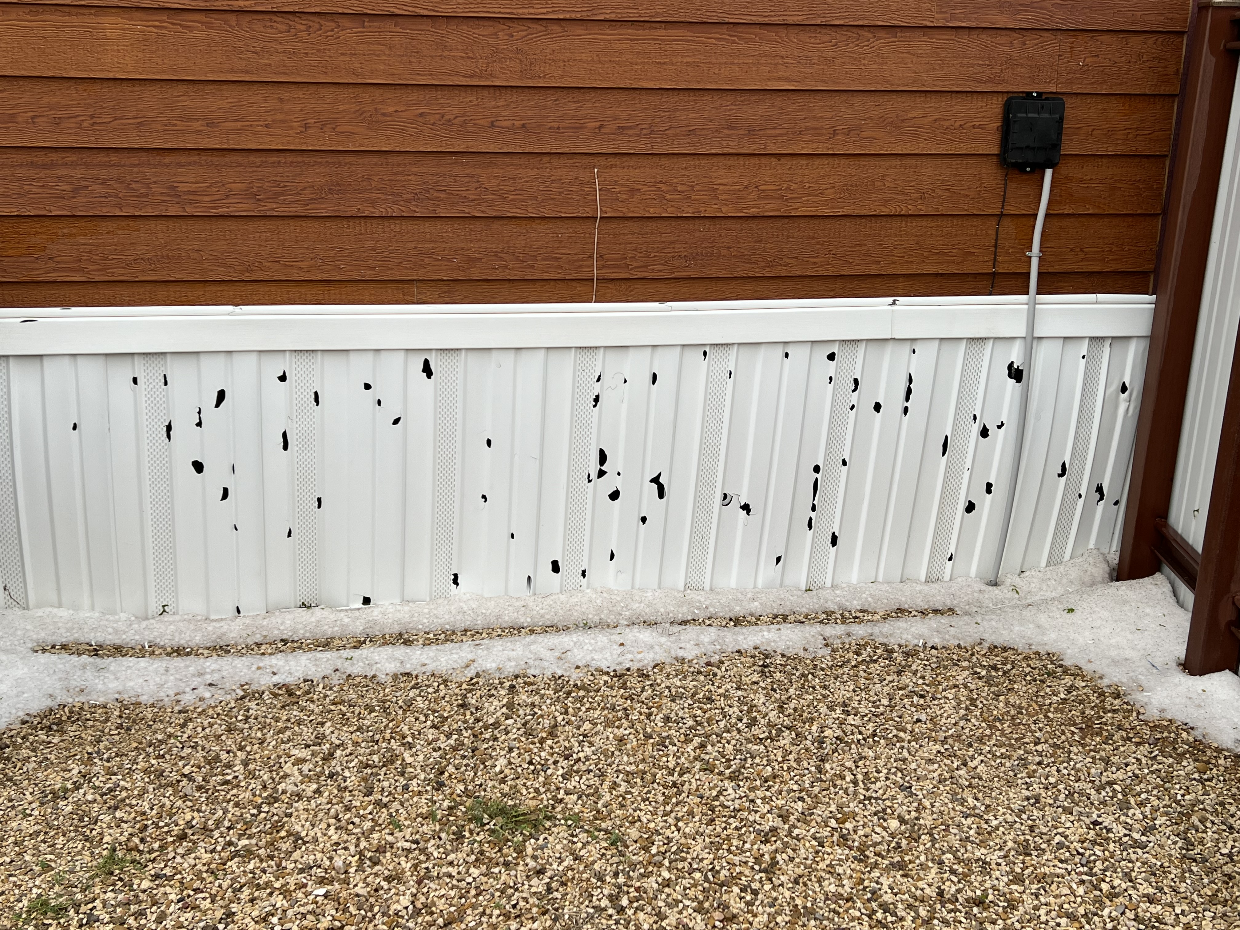
| Damage inflicted by severe thunderstorm winds near Lake Alan Henry on Tuesday morning, 9 April 2024. The picture is courtesy of Lake Alan Henry Weather. | |
|
The wind-driven hail did damage several buildings near Lake Alan Henry (as shown immediately above and at the top of this page). In addition, a porch and storage shed were heavily damaged near Shallowater and several powerlines were downed near Plainview form the severe winds early Tuesday. |
|
 |
|
| RBG "True Color" satellite loop valid from 8:06 am to 9:31 am on Tuesday, 9 March 2024. | |
|
Waves of rain, and embedded thunderstorms, continued as the moisture wrapped around the ejecting storm system through Tuesday afternoon and evening. The most widespread and persistent rain targeted the southern Texas Panhandle and parts of the northern South Plains through the second half of the event, before finally diminishing and shifting east early Wednesday. |
|
 |
|
| 2-day radar-estimated and bias-corrected precipitation ending at 7 am on Wednesday (10 April 2024). A regional view of this same information can be FOUND HERE. Measured rainfall over this same period, from the West Texas Mesonet (WTM), can be VIEWED HERE. In addition, WTM precipitation zoomed into the Lubbock County area can be SEEN HERE. | |
|
By the conclusion of the event, the entire South Plains region recorded meaningful rainfall. Rain totals of 1 to 2+ inches were common from the central South Plains into the southern Texas Panhandle. The highest rain amounts, in excess of 3 inches, were measured over the south-central Panhandle, centered in and around Palo Duro Canyon. Locations around Lubbock generally recorded totals around one inch. Storm reports collected from these active couple of days in early April can be found below: |
Preliminary Local Storm Report...Summary
National Weather Service Lubbock TX
116 PM CDT Tue Apr 9 2024

..TIME...   ...EVENT...      ...CITY LOCATION...     ...LAT.LON...
..DATE...   ....MAG....      ..COUNTY LOCATION..ST.. ...SOURCE....
            ..REMARKS..

0633 PM     Hail             3 E Post                33.20N 101.33W
04/08/2024  E1.75 Inch       Garza              TX   NWS Employee


0728 PM     Hail             1 NW Lake Alan Henry    33.08N 101.06W
04/08/2024  E1.00 Inch       Garza              TX   Public


0757 PM     Hail             1 W Slaton              33.44N 101.66W
04/08/2024  E1.00 Inch       Lubbock            TX   Broadcast Media


0836 PM     Hail             1 NNW Aspermont         33.15N 100.23W
04/08/2024  E1.00 Inch       Stonewall          TX   Public


0851 PM     Hail             1 NNW Crosbyton         33.65N 101.25W
04/08/2024  E0.88 Inch       Crosby             TX   CO-OP Observer


0904 PM     Hail             1 WNW Slaton            33.45N 101.66W
04/08/2024  E1.00 Inch       Lubbock            TX   Trained Spotter


0908 PM     Hail             1 WNW Slaton            33.45N 101.66W
04/08/2024  E1.25 Inch       Lubbock            TX   Trained Spotter

