|
Two days of wind, dust and critical fire weather |
|
 |
|
|
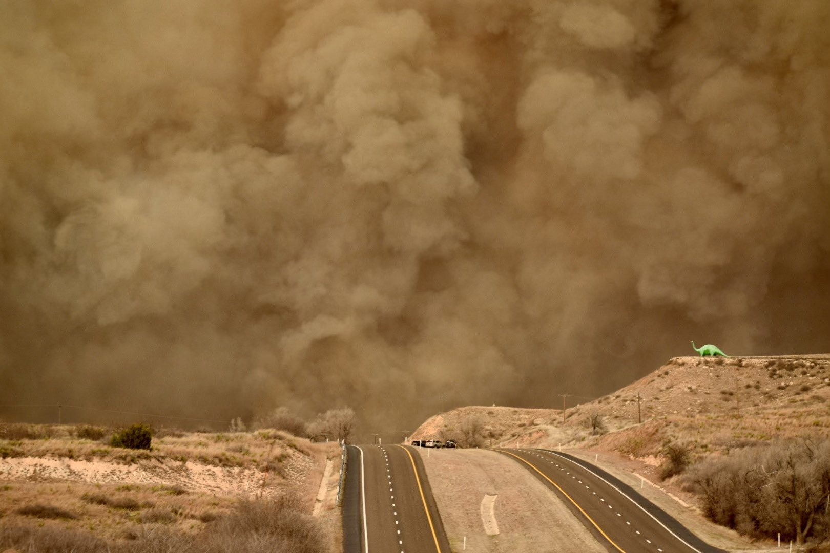
Smoke billowing from a large wildfire near Canadian, TX, around 3 pm on Tuesday afternoon (27 February 2024). The picture is courtesy of Chad Casey. |
|
|
A large storm system progressing through the central United States spread strong wind energy across a large portion of the nation, and the southern High Plains was not immune. Following a mild and breezy weekend, the winds ramped up in earnest Monday afternoon. In combination with the wind, near-record to record warmth and very dry air produced extremely favorable conditions for wildfires to develop and grow given ignition. |
|
 |
|
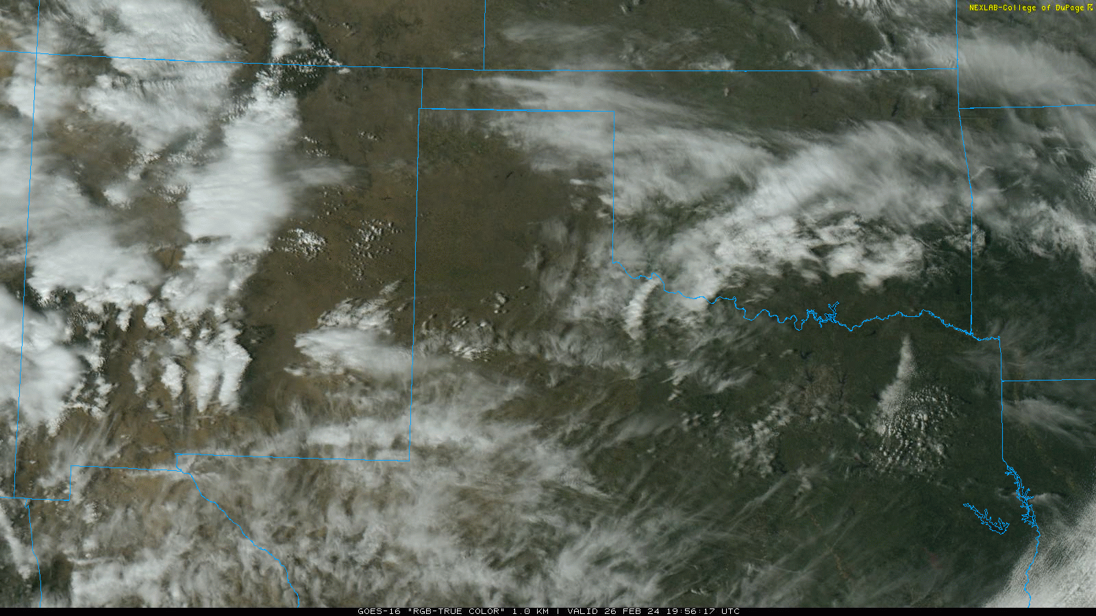
| RBG "True Color" satellite loop valid from 1:56 pm to 3:01 pm on Monday, 26 February 2024. | |
| Unfortunately, several fires did ignite on Monday across the southern High Plains, including a few that grew quickly to a significant size across the Texas Panhandle. The above satellite animation clearly shows a few smoke plumes streaming east from wildfires burning land in the Texas Panhandle, as well as more subtle dust spreading out of eastern New Mexico into the South Plains. | |
 |
 |
| High temperatures measured on Monday (26 February 2024), left, and Tuesday (27 February 2024), right. The data are courtesy of the West Texas Mesonet and the National Weather Service. | |
| The strong and dry westerly downslope winds, coupled with filtered sunshine, propelled temperatures into the 80s and lower 90s Monday afternoon. Officially, Lubbock reached 87ËšF, breaking the daily record (previous record was 85ËšF, set in 1918) for February 26th. Similarly, Childress set a new record when the mercury topped out at 90ËšF (previous record was 86ËšF, set in 1986). | |
 |
|
| Maximum wind gusts measured through Monday afternoon (26 February 2024). The data are courtesy of the West Texas Mesonet. The peak wind speeds measured on Monday can be VIEWED HERE. | |
| Peak wind gusts in excess of 50 mph were common from the northern South and Rolling Plains into the Texas Panhandle Monday afternoon. The wind dropped off to breezy levels Monday night, but returned with vengeance on Tuesday. | |
 |
|
| Shortwave Infrared satellite loop valid from 2:51 pm to 4:46 pm on Tuesday, 27 February 2024. | |
| Tuesday (27 February), was slightly cooler than Monday, but even windier, behind the passage of Pacific cold front. High temperatures "only" reached the 70s and lower 80s, and the relative humidity didn't fall as far as the prior day, but the intense winds stoked ongoing fires and supported the development of additional large wildfires. The strong winds also lifted dust over the South Plains, dropping the visibility as low as 2 miles in Lubbock Tuesday afternoon. | |
 |
|
| Smoke billowing from a large wildfire north of Wheeler, TX, around 5 pm on Tuesday afternoon (27 February 2024). The picture is courtesy of Chad Casey. | |
|
Wind gusts peaked at 50 to 60+ mph across much of the Texas Panhandle and South Plains from late Tuesday morning through the afternoon hours. The West Texas Mesonet (WTM) stations near Dumas and Miami measured gusts as high as 70 mph, fanning the flames and pushing nearby wildfires quickly to the east. |
|
 |
|
| Maximum wind gusts measured through early Tuesday evening (27 February 2024). The data are courtesy of the West Texas Mesonet. The peak wind speeds measured on Tuesday can be VIEWED HERE. | |
| Then, to add insult to injury, a strong Canadian cold front plunged southward through the region Tuesday afternoon and evening. The frontal passage resulted in an abrupt northerly wind shift which further compounded the danger in and around the wildfires, as the fire front changed from moving to the east to moving to the south. | |
 |
|
| Regional radar animation valid from 3:50 pm to 8:10 pm on Tuesday (27 February 2024). | |
|
The above radar animation clearly shows the leading edge of the cold front, as a fineline, moving southward through the Texas Panhandle and northwest Oklahoma. In addition to the cold front, several plumes of reflectivity returns (blues and greens) over this same region are the result of the radar sensing the smoke (and debris from the wildfires) being lofted then carried downwind. Initially, the smoke is spreading east, but it quickly changes to the south as the front moves through. |
|
 |
|
| Wall of smoke advancing southward near Childress Tuesday evening (27 February 2024). The picture is courtesy of Chad Casey. | |
| Strong cold fronts typically concentrate dust, and this one was no exception, but this front also carried copious amounts of smoke southward with it. The visibility at Childress briefly dropped below 1 mile immediately behind the front as the thick smoke spread over. Even Lubbock saw the visibility dip below 3 miles as the front (and smoke) moved through after 10 pm. Even though the visibility improved by Wednesday morning, the smell of smoke was still quite pungent in Lubbock. | |
 |
|
| 24-hour meteogram for the West Texas Mesonet site near Canadian, TX, on Tuesday (27 February 2024). The top plot shows the temperatures (2-m level in red, 1.5-m level in light pink and 9-m level in purple) and the dewpoint (in green). The middle graph displays the relative humidity (in light green) and leaf wetness (blue dots). The bottom graph shows the 10-m wind speed (dark blue), gust (light blue) and direction (light brown dots) as well as the 2-m wind speed (white). The full meteogram, including pressure, rainfall, solar radiation and soil temperature can be VIEWED HERE. | |
| When the fire near Canadian started moving south, it burned through the Canadian WTM site. The temperature there briefly jumped to excess of 120ËšF, as the above plot shows. Although the abrupt wind shift did further complicate the firefighting effort, cooler temperatures and increasing relative humidity did help temper the fire growth and spread somewhat, despite the still gusty winds persisting well into the evening. | |
 |
|
| Temperatures measured at 5:15 pm on Tuesday (27 February 2024). The map is courtesy of the West Texas Mesonet (WTM). A similar plot, valid at 8:10 pm, can be FOUND HERE. | |
| Wind reports collected from this windy, dusty and fiery stretch in late February 2024 can found below: | |
Preliminary Local Storm Report...Summary
National Weather Service Lubbock TX
1232 AM CST Wed Feb 28 2024

..TIME...   ...EVENT...      ...CITY LOCATION...     ...LAT.LON...
..DATE...   ....MAG....      ..COUNTY LOCATION..ST.. ...SOURCE....
            ..REMARKS..

0348 PM     Non-Tstm Wnd Gst Caprock Canyons State P 34.45N 101.07W
02/26/2024  M58 MPH          Briscoe            TX   Mesonet


1223 PM     Non-Tstm Wnd Gst 2 SSW Muleshoe          34.21N 102.74W
02/27/2024  M58 MPH          Bailey             TX   Mesonet


1223 PM     Non-Tstm Wnd Gst 2 SSW Muleshoe          34.21N 102.74W
02/27/2024  M58 MPH          Bailey             TX   Mesonet


1223 PM     Non-Tstm Wnd Gst 2 SSW Muleshoe          34.21N 102.74W
02/27/2024  M58 MPH          Bailey             TX   Mesonet


1246 PM     Non-Tstm Wnd Gst 7 WSW Lakeview          34.65N 100.81W
02/27/2024  M59 MPH          Hall               TX   Mesonet


1251 PM     Non-Tstm Wnd Gst 2 WSW Turkey            34.38N 100.93W
02/27/2024  M64 MPH          Hall               TX   Mesonet


1253 PM     Non-Tstm Wnd Gst Lubbock Int. Airport    33.66N 101.83W
02/27/2024  M62 MPH          Lubbock            TX   Public


1254 PM     Non-Tstm Wnd Gst 3 N Hart                34.42N 102.11W
02/27/2024  M58 MPH          Castro             TX   Mesonet


0105 PM     Non-Tstm Wnd Gst 7 ESE Silverton         34.45N 101.19W
02/27/2024  M58 MPH          Briscoe            TX   Mesonet


0333 PM     Non-Tstm Wnd Gst Sundown                 33.46N 102.49W
02/27/2024  M58 MPH          Hockley            TX   Mesonet


0333 PM     Non-Tstm Wnd Gst 8 SW Sundown            33.39N 102.61W
02/27/2024  M58 MPH          Cochran            TX   Mesonet

