|
Widespread snow falls on the South Plains |
|
 |
|
|
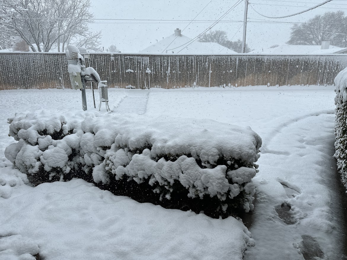
Heavy, wet snow blanketing Shallowater Sunday (11 February 2024) morning. The picture is courtesy of Bruce Haynie. |
|
|
A powerful storm system digging through the Four Corners provided widespread precipitation across the southern High Plains Saturday and Sunday, February 10th and 11th. |
|
 |
|
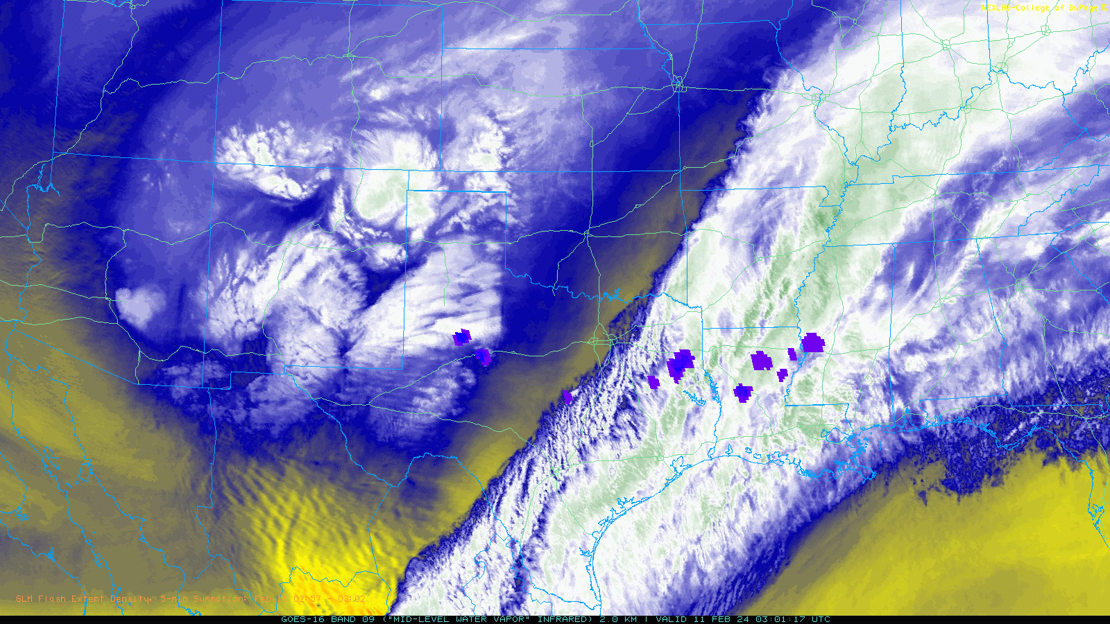
| Water vapor satellite loop valid from 9:01 pm to 11:41 pm on Saturday (10 February 2024). The Geostationary Lightning Mapper (GLM) Flash Extent Density is also plotted on top of the satellite imagery. | |
| Initially, spotty light rain affected the region Saturday morning and early afternoon as a disturbance ahead of the primary storm system emerged over the region. A good chunk of the South Plains did see sunshine and mild temperatures Saturday afternoon, but that quickly changed Saturday night as colder air moved in behind a backdoor cold front. Immediately in advance of the colder air, a broken line of thunderstorms formed over the southern Rolling Plains and eastern Permian Basin Saturday evening, but quickly shifted off to the east. | |
 |
|
| Snow and slush covered roadway in southern Lubbock County Sunday morning (11 February 2024). The image is courtesy of John Lipe. | |
| Behind the cold front temperatures dipped into the lower 30s and upper 20s by early Sunday, just as precipitation expanded in coverage and intensity as the primary storm system started to exert itself. The rain changed to snow from northwest-to-southeast across the South Plains and Rolling Plains Sunday morning as the colder air moved in. The exception was across the far southern Rolling Plains, around Aspermont, where temperatures remained mild enough to keep the precipitation a cold rain throughout. | |
 |
|
| Lubbock WSR-88D radar animation valid from 3:16 pm to 11:53 pm on Saturday (10 February 2024). | |
| The snow, heavy at times, continued through much of Superbowl Sunday for most of the South Plains, southern Texas Panhandle and northern and central Rolling Plains, before finally diminishing from west-to-east in the evening as the upper level system shifted of into Oklahoma and North Texas. | |
 |
|
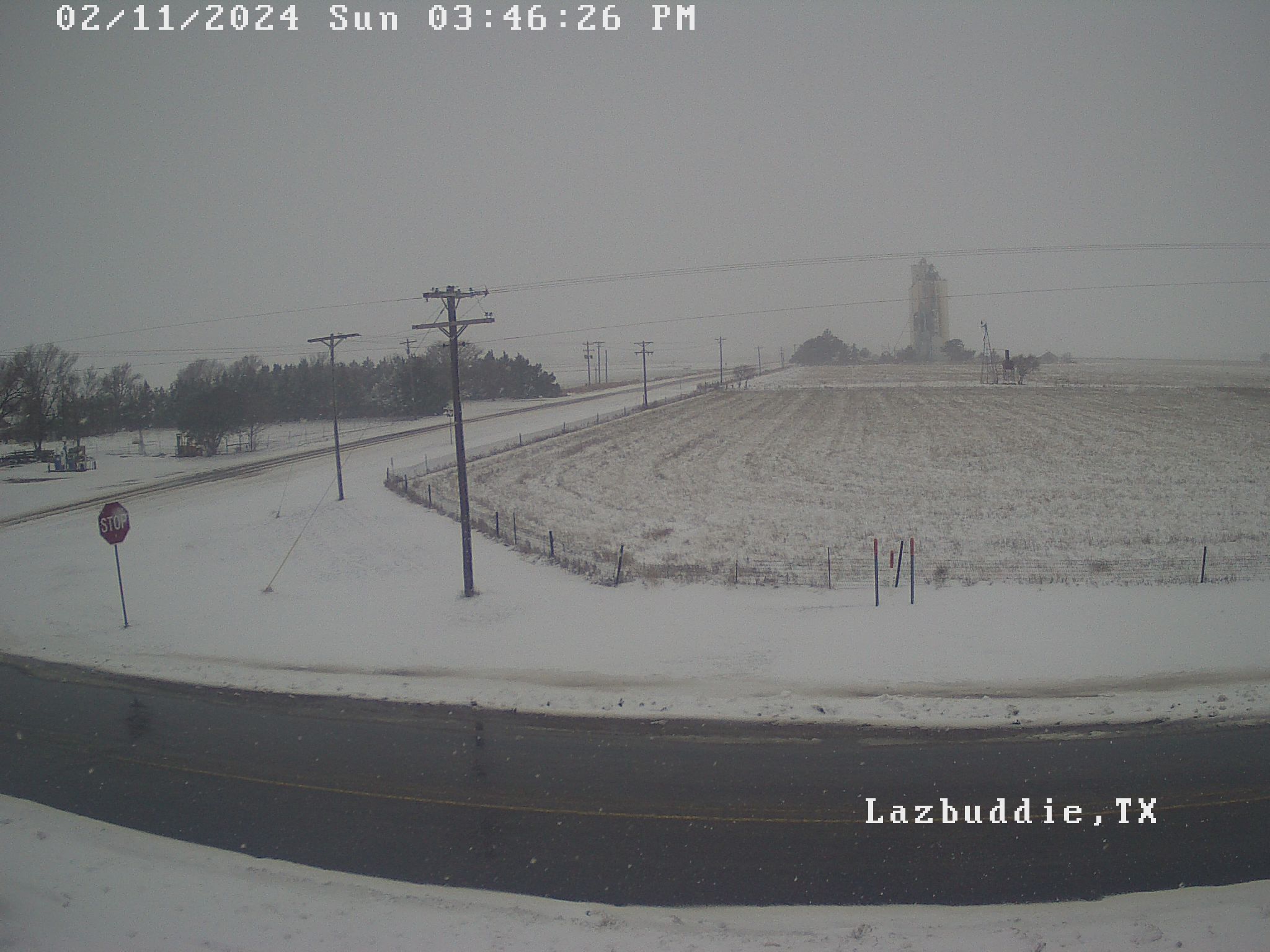
| A snowy scene near Lazbuddie, along with mostly wet roadways, Sunday afternoon (11 February 2024). | |
| The heaviest snow was concentrated across the northern South Plains and south-central Texas Panhandle where totals of a half foot to foot was common. The heavy snow created tricky travel thanks to slushy and snow-covered roadways. | |
 |
|
| Lubbock WSR-88D radar animation valid from 12:54 am to 10:52 am on Sunday (11 February 2024). | |
|
Around Lubbock, temperatures hovered around freezing through the day on Sunday, while snow totals of 2 to 5 inches were common. Slushy roads quickly melted when the snow intensity waned, leaving wet roadways through the late afternoon and evening. However, where moisture lingered on the roadways, it became ice as temperatures fell into the teens and lower 20s Monday morning. A few locations where the heaviest blanket of snow was in place even saw temperatures tumble into the single digits early Monday. |
|
 |
 |
| Snowy scene in Lubbock (left) and near Turkey (right), thanks to the mid-February snow. The pictures are courtesy of Jordan Salem and Blake-Brown, respectively. | |
| The heavy, wet snow did make for a beautiful sight, and was ideal for making snowballs, snowmen or just about anything you wanted to craft out of the snow. | |
 |
|
| Lubbock WSR-88D radar animation valid from 9:10 am to 12:39 pm on Sunday (11 February 2024). An additional radar animation, valid from 4:29 pm to 6:51 pm, can be VIEWED HERE. | |
|
Altogether, nearly the entire South Plains region received at least a little snow, while a couple inches or more were common from the central South Plains and northern Rolling Plains into the southern Texas Panhandle. Even where snow was elusive, welcome moisture did on the southern South and Rolling Plains. |
|
 |
|
| Estimated snowfall from Sunday, 11 February 2024. The reports are from the National Weather Service, COOP observers and the public. | |
| Full sunshine and warming temperatures allowed for quick improvement on the roadways by mid-late Monday morning. Where the heaviest snow fell, temperatures were slower to warm, only reaching the 30s, while other locations that received less snow saw the mercury rise into the 40s and lower 50s. | |
 |
|
| RBG "True Color" satellite loop valid captured the day after the snow, on Monday, 12 February 2024. | |
| The mild temperatures and abundant sunshine quickly melted the snow, as is illustrated in the above animation. Locations where only a few inches of snow or less existed quickly melted away Monday afternoon, leaving the brief wintry visit as just a memory. However, the band of heaviest snow persisted through Monday, and even Tuesday, despite strong insolation and increasingly mild temperatures. | |
 |
|
| Low temperatures measured Monday morning (12 February 2024). High temperatures measured that Monday afternoon can be VIEWED HERE. Both maps are courtesy of the West Texas Mesonet (WTM). | |
| The widespread snow, in combination with the initial bout of rain, brought welcome moisture to the entire region. Collectively, the rain and melted snow brought 1/4" to 3/4" of liquid to many locations, with totals near or in excess of an inch to a number of spots off the Caprock. | |
 |
|
| Total melted precipitation, as measured by the West Texas Mesonet (WTM), over the mid-February snow event. A close up of the Lubbock area can be FOUND HERE. Radar-estimated and bias-corrected precipitation for the South Plains region over this wintry event can be VIEWED HERE. | |
|
Officially, the Lubbock Airport measured 3.6 inches of snow and 0.47 inches of liquid (rain and melted snow) on Sunday, February 11th. The snowfall set a daily snowfall record, breaking the previous mark of 2.1 inches, set in 2010. Additional pictures from the wintry February day can be found below: |
|
 |
|
| View of downtown Childress Saturday evening (11 February 2024), courtesy of Pantex. | |
 |
|
| View of Friona Saturday evening (11 February 2024), courtesy of Pantex. | |
 |
|
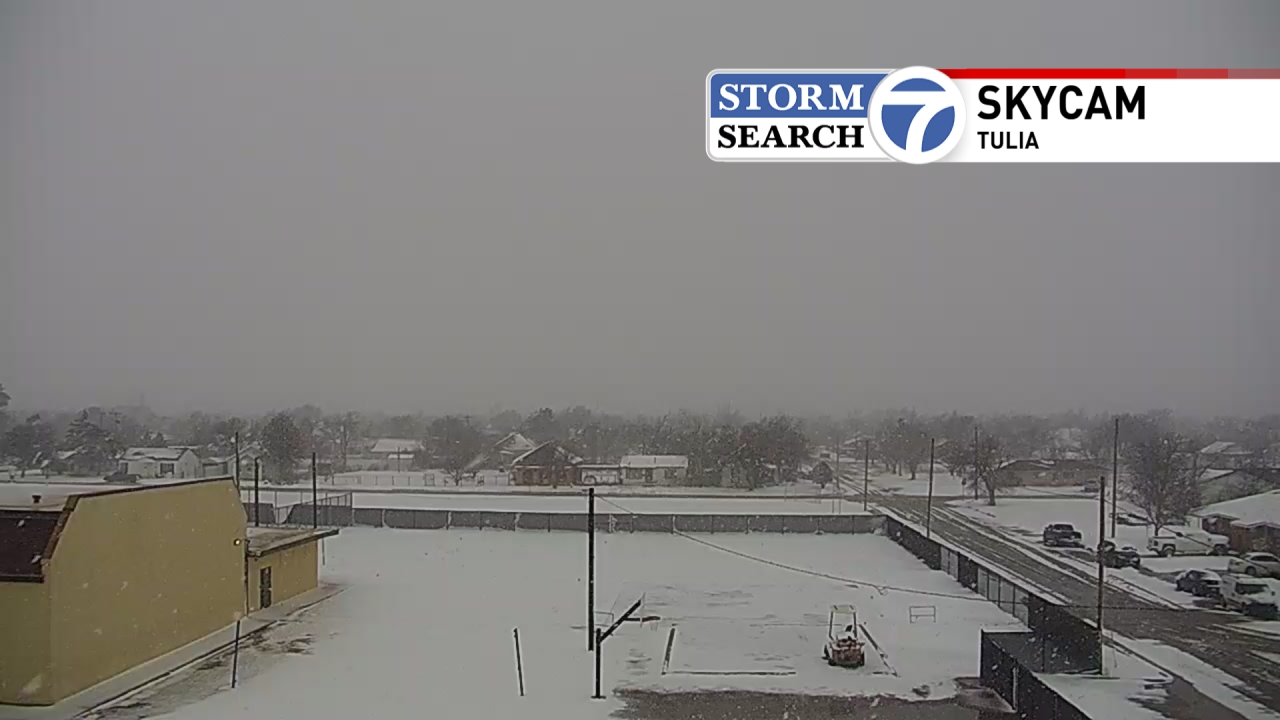
| View of Tulia Saturday afternoon (11 February 2024), courtesy of Storm Search 7. | |
| Snow reports collected from this impactful mid-February weather day can found below: | |
Preliminary Local Storm Report...Summary
National Weather Service Lubbock TX
1130 AM CST Mon Feb 12 2024

..TIME...   ...EVENT...      ...CITY LOCATION...     ...LAT.LON...
..DATE...   ....MAG....      ..COUNTY LOCATION..ST.. ...SOURCE....
            ..REMARKS..

1015 AM     Snow             Caprock Canyon St.      34.45N 101.07W
02/11/2024  E2.0 inch        Briscoe            TX   TX Park Svc

1030 AM     Snow             4 SSW Lubbock           33.53N 101.88W
02/11/2024  M2.5 inch        Lubbock            TX   NWS Office

1117 AM     Snow             Shallowater             33.69N 101.99W
02/11/2024  M5.0 inch        Lubbock            TX   NWS Employee

1125 AM     Snow             Smyer                   33.59N 102.16W
02/11/2024  E6.0 inch        Hockley            TX   Emergency Mngr

1126 AM     Snow             Levelland               33.58N 102.36W
02/11/2024  E3.0 inch        Hockley            TX   Emergency Mngr

1127 AM     Snow             Ropesville              33.41N 102.15W
02/11/2024  E6.0 inch        Hockley            TX   Emergency Mngr

1129 AM     Snow             Plainview               34.19N 101.72W
02/11/2024  E5.0 inch        Hale               TX   Law Enforcement

1133 AM     Snow             Floydada                33.98N 101.34W
02/11/2024  E8.0 inch        Floyd              TX   Emergency Mngr

1136 AM     Snow             Tulia                   34.54N 101.77W
02/11/2024  E2.0 inch        Swisher            TX   Law Enforcement

1139 AM     Snow             Littlefield             33.92N 102.33W
02/11/2024  M3.0 inch        Lamb               TX   Law Enforcement

1146 AM     Snow             6 NNE Lubbock           33.67N 101.82W
02/11/2024  M3.1 inch        Lubbock            TX   ASOS

            18Z Observation

0106 PM     Snow             4 E Reese Center        33.59N 101.96W
02/11/2024  M5.2 inch        Lubbock            TX   Co-Op Observer

0202 PM     Snow             Morton                  33.72N 102.76W
02/11/2024  E2.0 inch        Cochran            TX   Law Enforcement

0500 PM     Snow             Hart                    34.39N 102.11W
02/11/2024  M7.0 inch        Castro             TX   Co-Op Observer

            Measured by CO-OP observer.

0503 PM     Snow             Plainview               34.19N 101.72W
02/11/2024  M14.0 inch       Hale               TX   Broadcast Media

            Picture sent via Slack by broadcast media at the 806
            Pizza House in Plainview.

0525 PM     Snow             6 NNE Lubbock           33.66N 101.82W
02/11/2024  M3.3 inch        Lubbock            TX   Wx Observer FAA

            Storm total snowfall as of 5:25 PM CST.

0600 PM     Snow             Abernathy               33.83N 101.84W
02/11/2024  M8.0 inch        Hale               TX   Public

            Multiple reports from the public showing snow
            measurements of 7-8 inches in Abernathy.

0600 PM     Snow             New Deal                33.73N 101.84W
02/11/2024  E6.5 inch        Lubbock            TX   Public

1200 AM     Snow             4 SSW Lubbock           33.53N 101.88W
02/12/2024  M3.2 inch        Lubbock            TX   NWS Office

0600 AM     Snow             6 NNE Lubbock           33.67N 101.82W
02/12/2024  M3.6 inch        Lubbock            TX   ASOS

            Final total

0758 AM     Snow             Crosbyton               33.64N 101.24W
02/12/2024  M2.0 inch        Crosby             TX   Co-Op Observer

0803 AM     Snow             Hart                    34.39N 102.11W
02/12/2024  M8.5 inch        Castro             TX   Co-Op Observer

0830 AM     Snow             9 SE Floydada           33.89N 101.23W
02/12/2024  M5.0 inch        Floyd              TX   Co-Op Observer

0858 AM     Snow             Vigo Park               34.65N 101.50W
02/12/2024  E10.0 inch       Swisher            TX   Fire Dept/Rescue

0910 AM     Snow             Abernathy               33.83N 101.84W
02/12/2024  M9.0 inch        Lubbock            TX   Co-Op Observer

            Final Total

0911 AM     Snow             Dimmitt                 34.55N 102.32W
02/12/2024  M7.0 inch        Castro             TX   Co-Op Observer

            Final Total

0912 AM     Snow             Plainview               34.19N 101.72W
02/12/2024  M11.7 inch       Hale               TX   Co-Op Observer

            Final Total

0913 AM     Snow             Tulia                   34.54N 101.77W
02/12/2024  M5.0 inch        Swisher            TX   Co-Op Observer

            Final Total

0916 AM     Snow             Tahoka                  33.16N 101.79W
02/12/2024  M1.0 inch        Lynn               TX   Co-Op Observer

            Final Total

0927 AM     Snow             Littlefield             33.92N 102.33W
02/12/2024  M6.0 inch        Lamb               TX   Co-Op Observer

            Final Total

0928 AM     Snow             Matador                 34.02N 100.82W
02/12/2024  M4.0 inch        Motley             TX   Co-Op Observer

            Final Total

0929 AM     Snow             Olton                   34.18N 102.14W
02/12/2024  M11.0 inch       Lamb               TX   Co-Op Observer

            Final Total

0930 AM     Snow             7 E Paducah             34.01N 100.18W
02/12/2024  M3.0 inch        Cottle             TX   Co-Op Observer

            Final Total

0930 AM     Snow             Morton                  33.72N 102.76W
02/12/2024  M3.3 inch        Cochran            TX   Co-Op Observer

            Final Total

0931 AM     Snow             Brownfield              33.18N 102.27W
02/12/2024  M1.5 inch        Terry              TX   Co-Op Observer

            Final Total

0932 AM     Snow             Levelland               33.58N 102.36W
02/12/2024  M3.2 inch        Hockley            TX   Co-Op Observer

            Final Total

0933 AM     Snow             2 E Flomot              34.23N 100.95W
02/12/2024  M7.5 inch        Motley             TX   Co-Op Observer

            Final Total

0933 AM     Snow             7 NW Childress          34.50N 100.34W
02/12/2024  M2.3 inch        Childress          TX   Co-Op Observer

            Final Total

0934 AM     Snow             9 SE Floydada           33.89N 101.23W
02/12/2024  M5.0 inch        Floyd              TX   Co-Op Observer

            Final Total

0935 AM     Snow             6 NNW Ropesville        33.49N 102.19W
02/12/2024  M5.5 inch        Hockley            TX   Co-Op Observer

            Final Total

0935 AM     Snow             10 S Paducah            33.87N 100.30W
02/12/2024  M5.0 inch        Cottle             TX   Co-Op Observer

            Final Total

0937 AM     Snow             Shallowater             33.69N 101.99W
02/12/2024  M6.0 inch        Lubbock            TX   NWS Employee

            Final Total

0937 AM     Snow             Southland               33.36N 101.55W
02/12/2024  M1.8 inch        Garza              TX   Co-Op Observer

            Final Total

0938 AM     Snow             3 S Tell                34.34N 100.39W
02/12/2024  M4.0 inch        Childress          TX   Co-Op Observer

            Final Total

0939 AM     Snow             7 SW Lubbock            33.50N 101.96W
02/12/2024  M2.5 inch        Lubbock            TX   NWS Employee

            Final Total

0939 AM     Snow             3 W Woodrow             33.45N 101.90W
02/12/2024  M4.0 inch        Lubbock            TX   NWS Employee

            Final Total

0940 AM     Snow             4 E Reese Center        33.59N 101.96W
02/12/2024  M5.7 inch        Lubbock            TX   Co-Op Observer

            Final Total

0941 AM     Snow             Floydada                33.98N 101.34W
02/12/2024  M8.7 inch        Floyd              TX   Co-Op Observer

            Final Total

1040 AM     Snow             Muleshoe                34.23N 102.73W
02/12/2024  M4.5 inch        Bailey             TX   Co-Op Observer

            Final Total

1127 AM     Snow             Turkey                  34.39N 100.90W
02/12/2024  M10.0 inch       Hall               TX   Co-Op Observer

            Final Total

