|
Thunderstorms bring widespread rain to much of the South & Rolling Plains |
|
 |
|
|
View of a thunderstorm with heavy rain tracking over the northwest portion of Lubbock County Friday evening (30 June 2023). The picture is looking northwest from the south side of Lubbock at 6:30 pm. |
|
|
After a hot second half of June, with many afternoons bringing triple digit heat, the final day of the month brought a noticeable change. Temperatures backed off a bit as a storm system approached the region via the southern Rockies and Desert Southwest. In addition, rich Gulf moisture spread northward into the South Plains. As lift from the disturbance reached the improved moisture, scattered thunderstorms developed across the southwest Texas Panhandle and western South Plains Friday afternoon (30 June 2023). |
|
 |
|
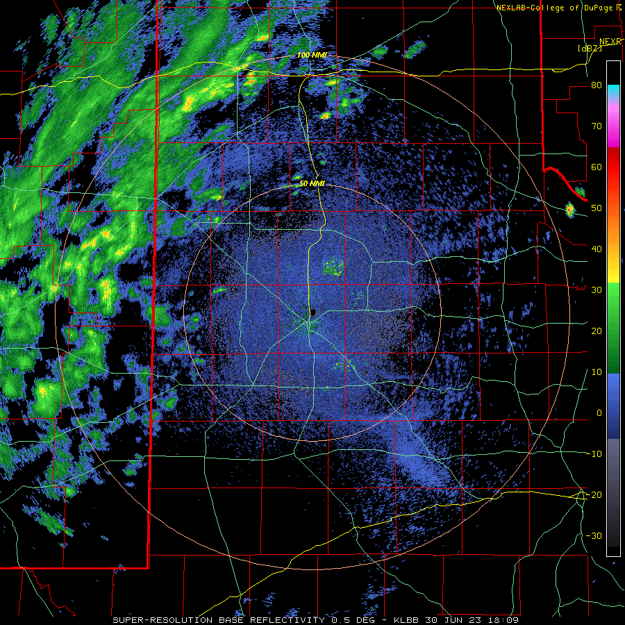
| Lubbock WSR-88D radar animation valid from 1:09 to 7:36 pm on Friday (30 June 2023). | |
| The thunderstorms grew upscale into clusters and eventually a line of storms as they propagated eastward through the late afternoon and evening hours. Torrential rainfall accompanied the most intense activity, which led to flooded roadways in places. One band of concentrated heavy rain became anchored from north-central Hockley County to southeast Lamb County, north of Levelland to southeast of Littlefield. Several inches of fell in over the course of a couple hours here, making travel difficult to impossible for a time along Highways 84 and 385. | |
 |
|
| Typical street flooding in Lubbock Friday (30 June) evening caused by brief moderate to heavy downpours. This image was captured at 5:22 pm at the intersection of 98th Street and Indiana Avenue. The picture is courtesy of the City of Lubbock. | |
| Additional heavy rain was more transient in nature, but still created at least minor flooding in spots, including parts of Lubbock Friday evening. As the thunderstorm coverage and its associated rain cool outflows grew in size, wind gusts increased, with many spots measuring gusts of 45 to 55+ mph. A couple of locations in the Rolling Plains recorded severe-caliber gusts, including 71 mph at the White River Lake West Texas Mesonet (WTM) located 6 mile northwest of the lake and 64 mph at the Spur WTM. | |
 |
|
| Visible satellite loop valid from 6:46 to 7:31 pm on 30 June 2023. Widespread thunderstorms, with numerous overshooting tops (causing shadows on top of the cloud deck), can be seen from western Oklahoma through West Texas as the sun angle drops in the west. | |
| The showers and thunderstorms gradually exited the Rolling Plains late Friday evening, but additional rounds of showers and thunderstorms did affect portions of the southeast Texas Panhandle, Rolling Plains and central and eastern South Plains into Saturday morning. A final, isolated batch of thunderstorms then developed and tracked over the northern Rolling Plains Saturday afternoon, bringing a quick half inch to inch in a swath from around Flomot to Paducah. | |
 |
|
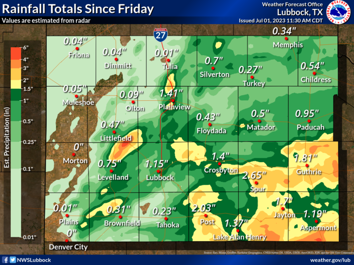
| 24-hour radar-estimated and bias-corrected (MRMS) rainfall ending at 10 am on Saturday (1 July 2023). Measured 48-hour rainfall from the West Texas Mesonet (WTM), ending at noon on Sunday (2 July) can be found at: South Plains View; and Close up of Lubbock Area. | |
|
Altogether, a good chunk of the central and eastern South Plains, the southeast Texas Panhandle and most of the Rolling Plains recorded 1/2 to 1+ inches of rain over this active end of June into the first day of July. Many spots in the Rolling Plains measured 1 to 2+ inches of rain, while 1/2 to 1 inch of rain was common in and around Lubbock. Officially, the Lubbock Airport measured 0.59 inches, which lifted the yearly total to 7.96 inches, which is 1.12 inches below normal. Although more localized, a small swath from near Whitharral to southeast of Spade likely had a quick 3 to 6 inches of rain according to radar, though no ground truth reports (other than flash flooding reports) were obtained from this area. On the other side of the spectrum, the far western South Plains into the southwest Texas Panhandle largely, or entirely, missed out on the rain. Preliminary storm reports from this active end of June can be found below: |
|
Preliminary Local Storm Report...Summary
National Weather Service Lubbock TX
1041 PM CDT Fri Jun 30 2023

..TIME...   ...EVENT...      ...CITY LOCATION...     ...LAT.LON...
..DATE...   ....MAG....      ..COUNTY LOCATION..ST.. ...SOURCE....
            ..REMARKS..

0400 PM     Rain             3 NW Anton              33.84N 102.20W
06/30/2023  U0.00 inch       Lamb               TX   Public

            Torrential rainfall ongoing. Traffic on Highway 84 is
            pulled over because of near zero visibility. Small hail
            and gusty winds also reported, though no known damage.

0412 PM     Flood            2 NW Anton              33.83N 102.19W
06/30/2023                   Lamb               TX   Public

            Public reported flooding on Highway 84.

0520 PM     Tstm Wnd Gst     6 SSW Anton             33.73N 102.19W
06/30/2023  M65 mph          Hockley            TX   Mesonet

            Measured by the West Texas Mesonet. A gust to 60 mph
            was also measwured at 5:19 pm.

0533 PM     Flash Flood      4 S Whitharral          33.68N 102.33W
06/30/2023                   Hockley            TX   Public

            Video of water flowing over the road at the
            Intersection of FM 1294 and Country Road.

0535 PM     Flash Flood      5 N Levelland           33.65N 102.36W
06/30/2023                   Hockley            TX   Law Enforcement

            Water reported over Highway 385 between Levelland and
            Withharral. Location is estimated.

0547 PM     Flash Flood      2 SE Spade              33.91N 102.13W
06/30/2023                   Lamb               TX   Law Enforcement

            Water over Highway 54 southeast of Spade.

0644 PM     Tstm Wnd Gst     6 NW White River Lake   33.53N 101.17W
06/30/2023  M71 mph          Crosby             TX   Mesonet

            Peak wind gust measured by the West Texas Mesonet.
            Additional severe caliber gusts occurred between 6:38
            and 6:45 PM, including a 70 mph wind gust at 6:38 PM.

0738 PM     Tstm Wnd Gst     1 W Spur                33.48N 100.88W
06/30/2023  M64 mph          Dickens            TX   Mesonet

            West Texas Mesonet.

