|
Torrential rain leads to flash flooding around O'Donnell & Post |
|
 |
|
|
Widespread flooding on Highway 87 north of O'Donnell on Thursday (1 June 2023). The image is courtesy of Aaron Rigsby. |
|
|
Rich moisture, a weak upper level disturbance and several low-level boundaries worked in concert to bring torrential rainfall to portions of the south-central and southeastern South Plains on the first day of June (Thursday morning and early afternoon). One of the primary factors, in addition to the plentiful humidity, was a low-level boundary, originating from thunderstorm activity that affected the Texas Panhandle the previous evening into the overnight hours, that provided a focus for shower and thunderstorm development. |
|
 |
|
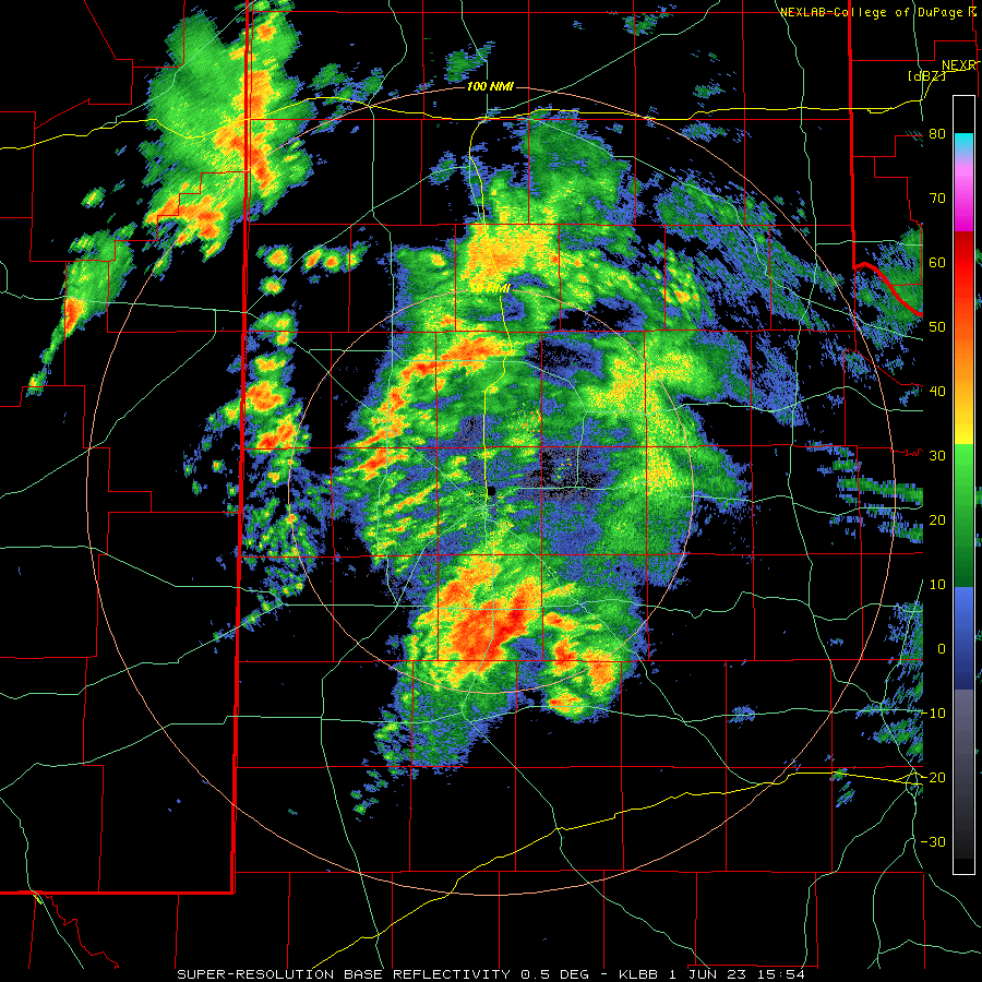
| Lubbock WSR-88D radar animation valid from 6:07 am to 10:15 am on Thursday (1 June 2023). Additional radar animations can be viewed at: 1:10 am to 5:27 am Thursday morning; and 10:54 am to 5:59 pm on Thursday. | |
| Initially, the showers and thunderstorms that formed across the central and southern South Plains early Thursday morning were on the scattered side, bringing brief bursts of moderate to heavy rain. However, that quickly changed as more widespread and intense thunderstorms became anchored over the south-central South Plains, including a good chunk of Lynn County. An instantaneous rain rate of 7.2 inches/hour was briefly measured at the O'Donnell West Texas Mesonet site located on the southwest edge of town, with persistent 1-minute totals of 0.05 to 0.10 inches. | |
 |
|
| Torrential rainfall and flooding along Highway 87 just south of Tahoka Thursday morning (1 June 2023). The picture is courtesy of Aaron Rigsby. | |
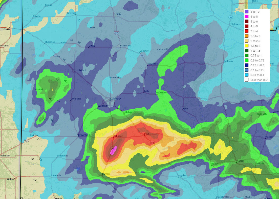
| The torrential rainfall rates continued for nearly two hours, from around 9:30 am to 11:30 am, before finally diminishing, then ending completely by early afternoon. Before all was said and done, the O'Donnell WTM measured an incredible 7.02", much of which fell in the 2 hour window mid-late morning. The below radar-estimated rainfall graphic indicates that O'Donnell, located just south of the bend in the road between Tahoka and Lamesa, felt the brunt of the heaviest rainfall. | |
 |
|
| 24-hour radar-estimated and bias-corrected rainfall ending at 7 am on Friday (2 June 2023). A zoomed out view of the South Plains region can be FOUND HERE. Measured 24 -hour rainfall from the West Texas Mesonet (WTM) ending at 6:15 pm on 1 June can be found at: South Plains View; and Close up of the southern South Plains. | |
| The area of heaviest thunderstorms eventually shifted northeastward late morning and early afternoon, dropping widespread 3 to 4+ inch totals from Tahoka to Post. The intense rainfall rates and impressive rain totals led to significant flash flooding that affected much of Highway 87 between Tahoka and Lamesa as well as Highway 380 from Tahoka to east of Post. | |
 |
|
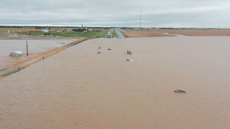
| Flooded out vehicles on Highway 87 between Tahoka and O'Donnell around midday Thursday (1 June 2023). The image is courtesy of Aaron Rigsby. | |
|
The rapid onset of flooding resulted in numerous vehicles becoming inundated by water on the highways (and other lesser traveled roads), and ultimately resulted in the closure of portions of Highways 87 and 380 from Thursday into Friday. Thankfully, no significant injuries resulted from the flooding, but many water rescues occurred and many vehicles were incapacitated. |
|
 |
 |
| (left) Flooded vehicle on Highway 87 roadway Thursday afternoon (1 June 2023). The picture is courtesy of Larry Rodriguez. (right) Flooded roadways early Friday morning (2 June 2023), courtesy of TXDOT. | |
| Plenty of the flood waters were channeled into nearby creeks and streams, including those that are a part of the Lake Alan Henry watershed. Normally dry or low-flowing creeks and streams became rushing rivers in the matter of minutes, as captured in the pictures below. | |
 |
 |
| Water flowing quickly toward Lake Alan Henry Thursday afternoon (1 June 2023). The left image is of the Double Mountain Fork of the Brazos River and is courtesy of @LakeAlanHenryWx on Twitter. The right image is of Grape Creek and is courtesy of Jeremy Carter. | |
| The Double Mountain Fork of the Brazos River near Justiceburg (southeast of Post) jumped from its base flow around 7 feet to a crest of 14 feet over the course of a few hours, then dropped back below flood stage (10 feet) almost as quickly. | |
 |
|
| Trace of the water level (blue) and forecast (purple) for the Double Mountain Fork Brazos River immediately upstream of Lake Alan Henry in early June 2023. | |
|
The extreme runoff from the intense rainfall did have at least one positive outcome, as it fed directly into Lake Alan Henry, boosting the reservoir level a few feet in about a day. This quick jump, along with other rises associated with the wet second half of May, lifted the lake over 8 feet. This raised the lake from 70.7% of capacity in early May to 91.8% full in early June. |
|
 |
|
| Lake Alan Henry water in late May and early June 2023. | |
|
Preliminary storm reports collected on June 1st can be found below: |
|
Preliminary Local Storm Report
National Weather Service Lubbock TX
317 PM CDT Thu Jun 01 2023

..TIME...   ...EVENT...      ...CITY LOCATION...     ...LAT.LON...
..DATE...   ....MAG....      ..COUNTY LOCATION..ST.. ...SOURCE....
            ..REMARKS..

0255 AM     Non-Tstm Wnd Gst 2 NE Slaton             33.46N 101.62W
06/01/2023  M59 mph          Lubbock            TX   Mesonet

            Outflow from nearby showers

0436 AM     Non-Tstm Wnd Gst 6 SSW Wolfforth         33.42N 102.05W
06/01/2023  M65 mph          Lubbock            TX   Mesonet

            Outflow from nearby shower

1150 AM     Rain             1 N O`Donnell           32.98N 101.83W
06/01/2023  M5.24 inch       Lynn               TX   Mesonet

            Mesonet Location Corrected: West Texas Mesonet station
            near O`Donnell reported 5.24 inches of rainfall in 2
            hours. Daily total was up to 6.66 inches.

1150 AM     Flash Flood      2 SW Skeen              33.04N 101.81W
06/01/2023                   Lynn               TX   Law Enforcement

            Flash flooding has resulted in the closure of US 87
            approximately 4 miles north of O`Donnell.

0102 PM     Flash Flood      2 WSW Pleasant Valley   33.26N 101.53W
06/01/2023                   Garza              TX   Law Enforcement

            Several roads west and northwest of Post under water
            including; FM211, FM212, FM2282 and HWY380.

0128 PM     Flash Flood      6 ENE Buenos            33.32N 101.39W
06/01/2023                   Garza              TX   Law Enforcement

            Water over bridge at the North Fork Brazos River
            crossing along HWY 207.

0128 PM     Flash Flood      1 E Pleasant Valley     33.27N 101.49W
06/01/2023                   Garza              TX   Law Enforcement

            Semi rollover and multiple car accident at US84 and
            FM399 due to water on roadway and heavy rainfall causing
            reduced visibility.

0226 PM     Tstm Wnd Gst     2 NNE Floydada          34.00N 101.33W
06/01/2023  M61 mph          Floyd              TX   Mesonet

            Floydada mesonet gusts to 61 mph at 226pm and 227pm.

