|
Prolonged dry, rounds of wind, dust and fire weather |
|
 |
|
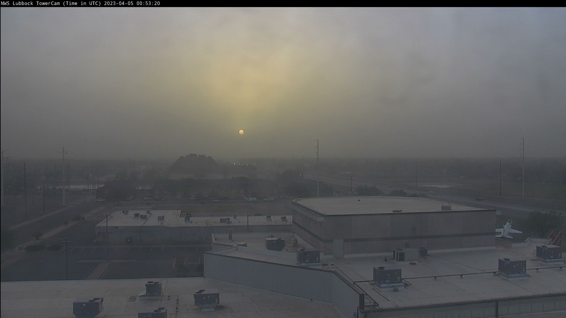
| Dusty Lubbock skyline Tuesday evening (4 April 2023) shortly before sunset. | |
|
During much of March and early April 2023, the jet stream carrying the storm systems across the United States decided to remain parked to the north of West Texas. This meant that any system that moved through, including the intense ones, left the South Plains region on the dry and windy south side. |
|
 |
|
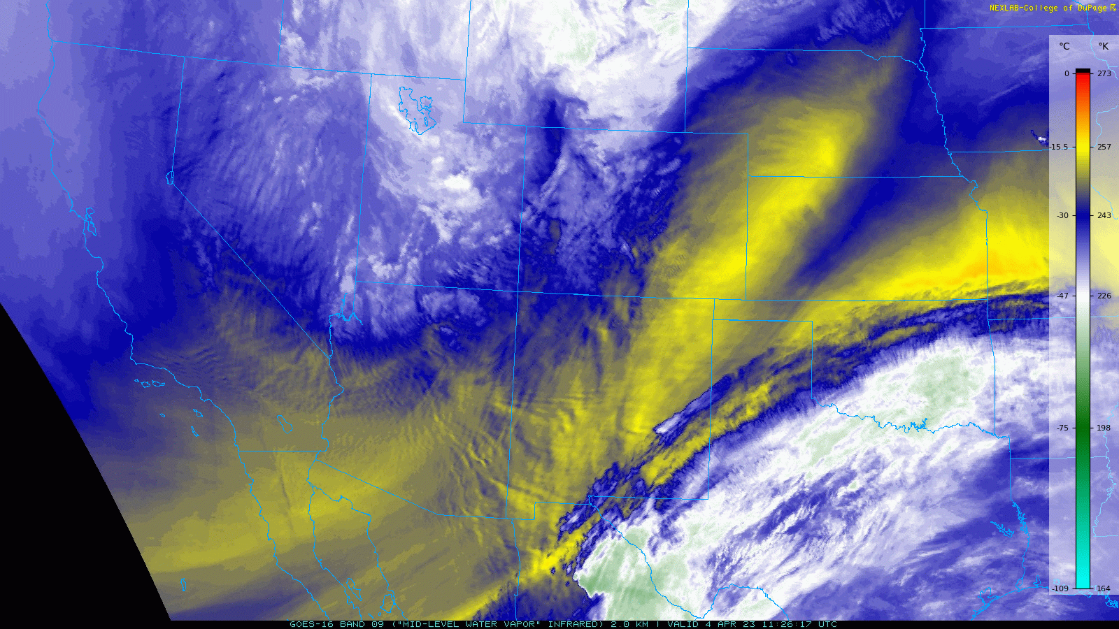
| Water vapor satellite loop valid from 11:51 am to 12:46 pm on Tuesday (4 April 2023). | |
| One particularly strong system emerged from the central Rockies on Tuesday, April 4th. Where moisture was present, blizzard conditions developed over much of the Dakotas and northwestern Minnesota, on the north side of the system. Farther south and east, another round of severe thunderstorms, including tornadic thunderstorms, hit portions of the Midwest into the central Mississippi River Valley. | |
 |
|
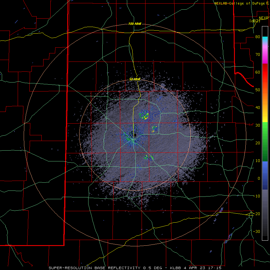
| Lubbock WSR-88D radar animation valid from 11:15 am to 2:31 pm Tuesday (4 March). The plume emanating from east-central Bailey is smoke/ash/embers being lofted from a wildfire. | |
| While rich Gulf moisture did get as close as western North Texas, eastern New Mexico into the Texas Panhandle and South Plains experienced the driest air of the spring to this point, with the relative humidity falling into the lower single digits (2-3%). The dry air, coupled with southwesterly winds gusting as high as 50 to 70 mph, lofted plenty of dust and supported the development and spread of several wildfires. Many locations experienced the visibility falling to 1 to 2 miles as a result of the thick blowing dust, with localized visibility near zero reported. | |
 |
|
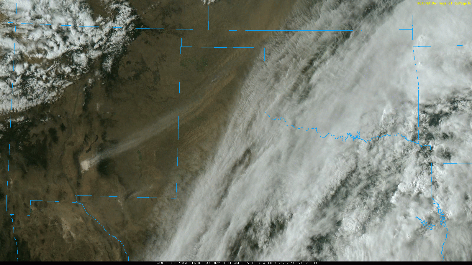
| "RGB-True Color" satellite animation valid from 5:06 pm to 5:56 pm on Tuesday (4 April 2023). White sand is clearly seen being carried northeastward from White Sands National Park in south-central New Mexico. | |
|
The above satellite imagery clearly shows a plume of white sand emanating from White Sands National Park, with additional more "classic" brown and red dust sourced from northern Mexico, Far West Texas, southeast New Mexico and the western South Plains. Smoke from a large wildfire near Amarillo is also clearly seen rising through the white sand plume over the central Texas Panhandle. |
|
 |
|
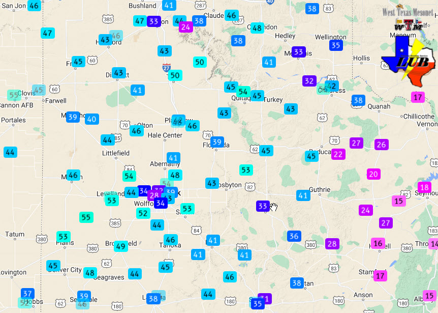
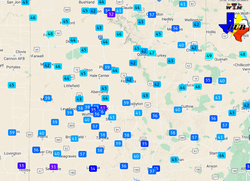
| Current wind gusts measured at 1:30 pm on Tuesday (4 April). The data are courtesy of the West Texas Mesonet (WTM). | |
| Above is a snapshot of the wind gusts at 1:30 pm on Tuesday. Wind gusts of 45 to 60 mph were common over much of the Caprock from late morning through early evening. Several of the peak severe gusts (58+ mph) occurred around midday, with another round favoring the late afternoon and early evening when high clouds gradually cleared and allowed for deeper mixing. The winds decreased after sunset, but remained solidly breezy into the next morning. | |
 |
|
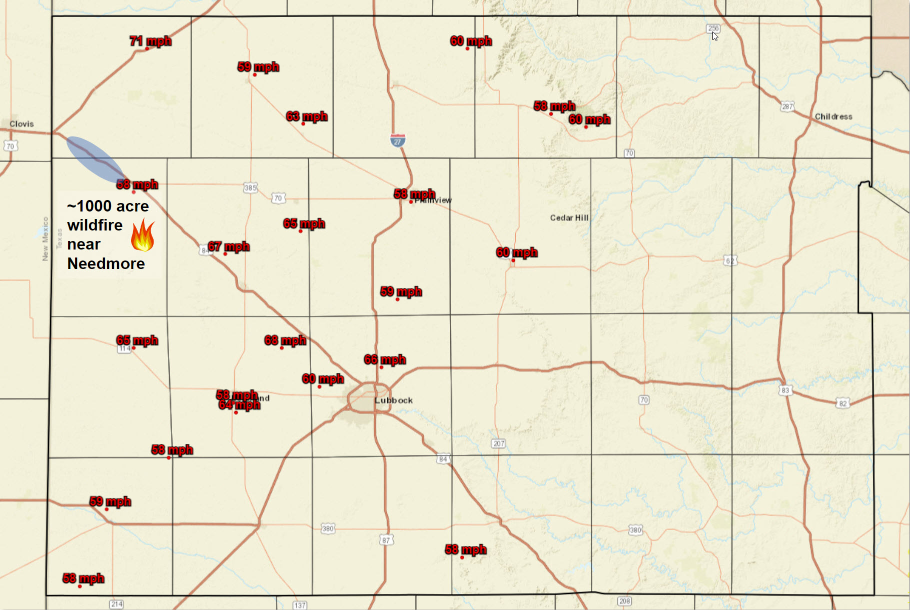
| Peak wind gusts measured on Tuesday (4 April 2023). Also shown is the approximate location of a large wildfire that consumed portions of east-central Bailey County. The shaded blue area depicts where thick blowing dust occurred Tuesday afternoon. | |
| The dry, windy and dusty conditions had the greatest impacts across the southwest Texas Panhandle and northwest South Plains, as displayed in the above graphic. One large wildfire developed and spread through parts of eastern Bailey County, while thick blowing dust contributed to several crashes on Highway 84 northwest of Muleshoe. | |
 |
|
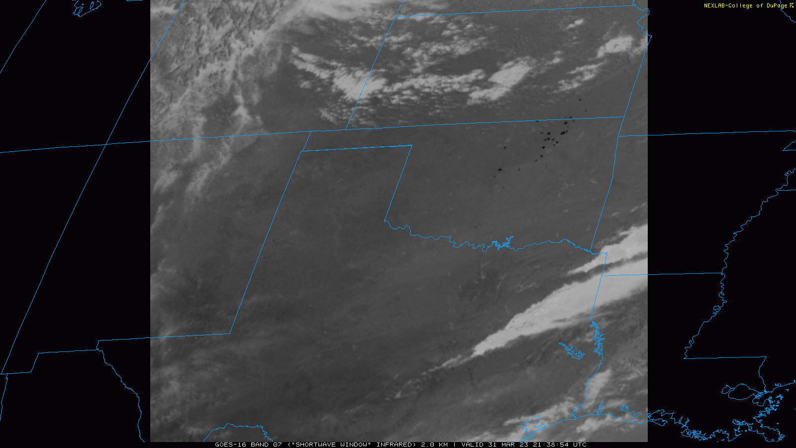
| Infrared satellite loop valid from 3:39 pm to 3:48 pm on Friday (31 March 2023). The "hot spots," or black areas, are locations where wildfires are ongoing. | |
|
The wind and dust on Tuesday, April 4th, felt like deja vu from just four days earlier. The previous Friday (March 31st) saw another storm system emerge well to our north, bringing heavy snow to the Upper Midwest, tornadic storms to the central portion of the country and wind and dust to West Texas. The dry and windy conditions also fanned many fires over north-central and northeast Oklahoma, as is seen above. |
|
 |
|
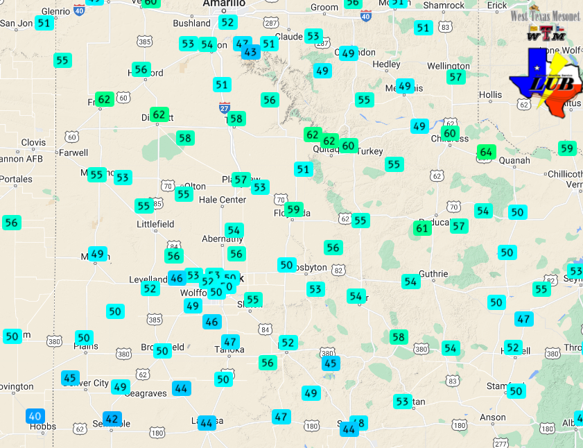
| Peak wind gusts measured on Friday (31 March). The data are courtesy of the West Texas Mesonet (WTM). The highest sustained wind speeds measured by the WTM on the 31st can be FOUND HERE. | |
| The most intense winds on March 31st swept across the southern Texas Panhandle into the northern Rolling Plains. Peak gusts of 45 to 55 mph were common across the region, with gusts near and above 60 mph where the strongest winds occurred. | |
 |
|
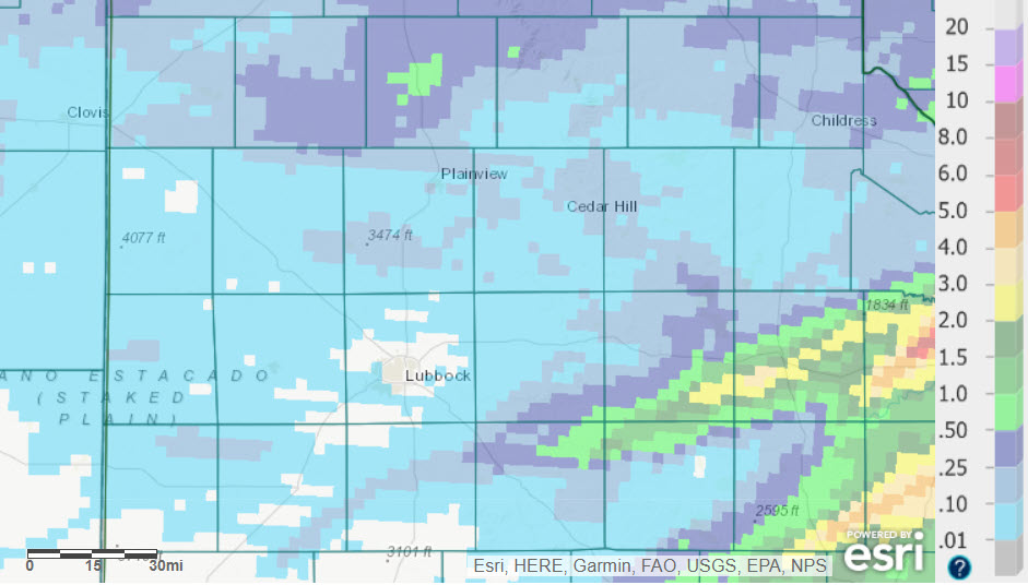
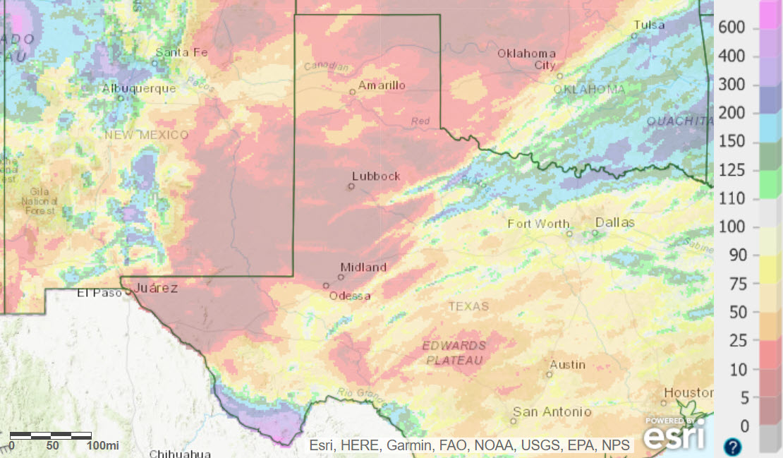
| March 2023 radar-estimated and bias-correct rainfall. March's rainfall, as a percent of normal, can be FOUND HERE. An expanded view of March's rainfall, including most of Texas, can be found at: Total Rainfall and Percent of Normal | |
|
Not surprisingly, the strong and dry winds kept precipitation largely void from the region in March 2023. Several spots, including around Lubbock, recorded trace amounts or no precipitation throughout the entire month of March. A few lucky spots did record a quick inch or two as thunderstorms developed and trained across portions of the central and southern Rolling Plains early in the month, while the southern Texas Panhandle recorded light amount mid-month. Officially, the Lubbock Airport recorded a trace of precipitation on 4 different days in March, finishing 1.10 inches below the monthly average. Childress managed to record 0.23 inches of rain in March, but still finished 1.13 inches below their monthly average. |
|
|
Preliminary wind, dust and wildfire reports in late March and early April 2023 can be found below: |
|
PRELIMINARY LOCAL STORM REPORT...SUMMARY
NATIONAL WEATHER SERVICE LUBBOCK TX
854 PM CDT FRI MAR 31 2023

..TIME...   ...EVENT...      ...CITY LOCATION...     ...LAT.LON...
..DATE...   ....MAG....      ..COUNTY LOCATION..ST.. ...SOURCE....
            ..REMARKS..

1021 AM     NON-TSTM WND GST 10 SW PADUCAH           33.89N 100.40W
03/31/2023  M61 MPH          COTTLE             TX   MESONET

1032 AM     NON-TSTM WND GST 2 WSW TURKEY            34.38N 100.93W
03/31/2023  M60 MPH          HALL               TX   MESONET

1036 AM     NON-TSTM WND GST 2 NNE CHILDRESS         34.46N 100.20W
03/31/2023  M60 MPH          CHILDRESS          TX   MESONET

1150 AM     NON-TSTM WND GST 7 ESE SILVERTON         34.45N 101.19W
03/31/2023  M63 MPH          BRISCOE            TX   MESONET

            WEST TEXAS MESONET

1221 PM     NON-TSTM WND GST 2 NE FRIONA             34.65N 102.69W
03/31/2023  M58 MPH          PARMER             TX   MESONET

            WEST TEXAS MESONET

1231 PM     NON-TSTM WND GST 1 SSE JAYTON            33.23N 100.57W
03/31/2023  M58 MPH          KENT               TX   MESONET

            WEST TEXAS MESONET

0104 PM     NON-TSTM WND GST 3 N HART                34.42N 102.11W
03/31/2023  M58 MPH          CASTRO             TX   MESONET

            WEST TEXAS MESONET

0114 PM     NON-TSTM WND GST 2 ENE TULIA             34.54N 101.74W
03/31/2023  M58 MPH          SWISHER            TX   MESONET

            WEST TEXAS MESONET

0130 PM     NON-TSTM WND GST 2 NE FRIONA             34.65N 102.69W
03/31/2023  M63 MPH          PARMER             TX   MESONET

            WEST TEXAS MESONET

0207 PM     NON-TSTM WND GST 2 NE DIMMITT            34.57N 102.29W
03/31/2023  M63 MPH          CASTRO             TX   MESONET

            WEST TEXAS MESONET

0218 PM     NON-TSTM WND GST CAPROCK CANYON SP       34.41N 101.06W
03/31/2023  M61 MPH          BRISCOE            TX   MESONET

            WEST TEXAS MESONET

0253 PM     NON-TSTM WND GST 6 NNE LUBBOCK           33.67N 101.82W
03/31/2023  M59 MPH          LUBBOCK            TX   ASOS

0309 PM     NON-TSTM WND GST 2 NNE FLOYDADA          34.00N 101.33W
03/31/2023  M59 MPH          FLOYD              TX   MESONET

            WEST TEXAS MESONET

0440 PM     NON-TSTM WND GST 2 WSW TURKEY            34.38N 100.93W
03/31/2023  M59 MPH          HALL               TX   MESONET

            WEST TEXAS MESONET

