|
A brief bout of storms, then LOTS of wind & dust |
|
 |
|
| A dusty view of Texas Tech University on Tuesday (14 February 2023). The image is courtesy Billy Faletti via twitter. | |
|
A powerful storm system tracking out of the Desert Southwest brought widespread impacts to much of the center of the nation in mid-February. Across the northern and mountainous sections, impacts included snow, blowing snow and blizzard conditions. Farther south, showers and thunderstorms were common across the southern High Plains, including over the South Plains region, Monday evening/night (13 February), followed by widespread wind and blowing dust on Tuesday and again on Wednesday. |
|
 |
|
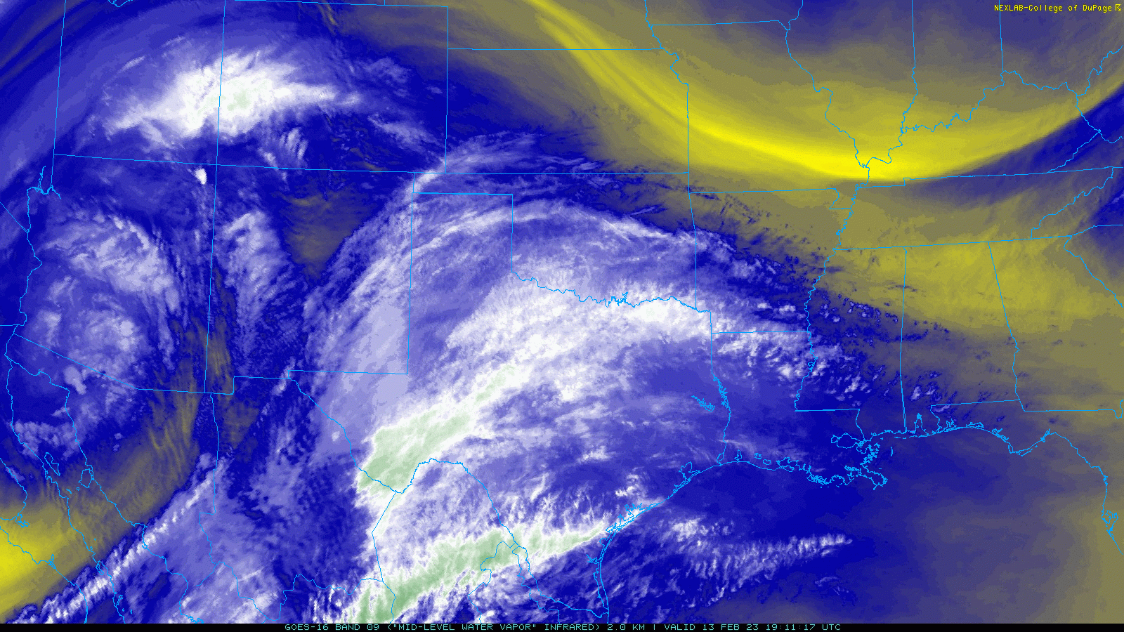
| Regional water vapor satellite loop captured early Monday afternoon (13 February 2023). | |
|
As the dynamic storm system tapped better moisture and instability levels, some thunderstorms became severe in spots across the south-central into the eastern portion of the nation by Wednesday and Thursday (15-16 February). |
|
 |
|
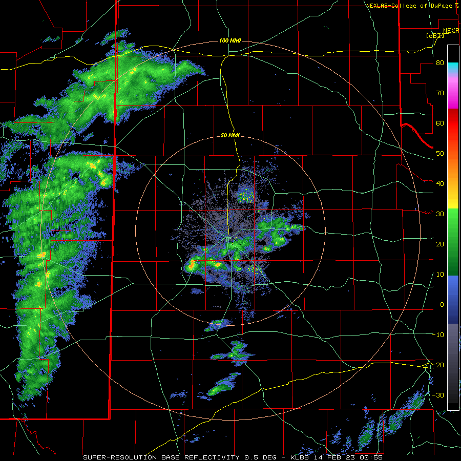
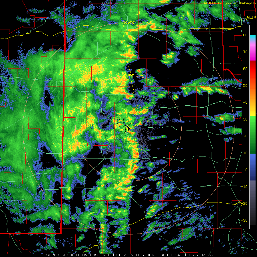
| Lubbock WSR-88D radar animation valid from 6:01 to 9:30 pm on Monday night (13 February). An additional radar animation valid from 9:39 pm on the 13th to 6:27 am on the 14th can be VIEWED HERE. | |
|
Regardless of your elevation or latitude (north, central or south), everyone experienced the expansive wind field of the impressive winter storm. Although both moisture and instability were limited here in West Texas, lift in advance of the storm system was strong enough to generate widespread, but quick-moving and thus short-lived, thunderstorms Monday evening. A few of the storms were even intense enough to generate spotty small hail, as big as dimes in Brownfield. |
|
 |
|
| 24-hour radar-estimated and bias-corrected precipitation ending at 6 am on Tuesday (14 February). The rain totals measured by the West Texas Mesonet for this event can be FOUND HERE. | |
|
The lightning and thunder were foreboding of the rapidly approaching spring severe weather season, but the limited instability help mitigate storm strength. Although a few locations did experience hail, all hail and wind gusts associated with the thunderstorms Monday evening/night were sub-severe across the South Plains. |
|
 |
|
| Regional water vapor satellite loop captured mid-morning on Tuesday (14 February 2023). | |
| Unfortunately, the quick storm motions limited rainfall duration at any given location. Thus, although nearly everyone across northwestern Texas did received rainfall Monday evening, rain totals were on the light side. Most spots measured rain amounts near or under a tenth of an inch, though portions of the southwest Texas Panhandle, as well as a few places in the Rolling Plains, recorded totals near a quarter inch. | |
 |
|
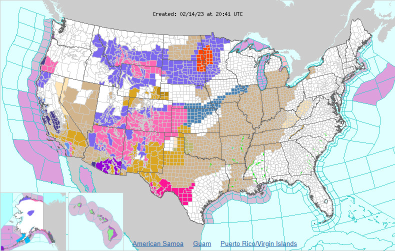
| Watch, warning and advisory map valid for the entire United States Tuesday afternoon (14 February). | |
| Following the brief bout of rain, the storm rapidly ejected into the central High Plains early Tuesday. This caused the dry and intense sinking westerly flow around the south side of the system to sweep across the southern High Plains Tuesday morning. Winds quickly increased Tuesday morning, peaking between mid-morning and midday before gradually decreasing through the afternoon hours. | |
 |
 |
| Pictures of a dusty sky in Amherst (left) and a toppled truck north of Ralls (right) on Tuesday. The images are courtesy of Five Area Telephone Cooperative and the Crosby County Sherriff's Department, respectively. | |
| The wind field was quite impressive, with nearly all of West Texas inflicted by wind gusts in excess of 50 mph. In fact, peak wind gusts of 60 to 70+ mph were common across the southern Texas Panhandle and adjacent northern and central South and Rolling Plains. Several West Texas Mesonet sites, including near Amherst, Silverton, Turkey and Caprock Canyons State Park measured wind gusts of 71 to 72 mph. | |
 |
|
| GeoColor satellite animation valid from 2:36 pm to 3:51 pm on Tuesday (14 February). A similar "True-Color" satellite loop early Tuesday afternoon can be VIEWED HERE. | |
| The intense winds did cause areas of property damage, including rolling multiple semi-tractor trailers off the interstate south of Tulia, where the cross-wind was maximized on Interstate 27. The wind also lofted copious amounts of dust, which further contributed to travel difficulties, and resulted in increased respiratory health concerns. The thick dust did cause several multi-vehicle accidents over the Oklahoma and northeast Texas Panhandles. | |
 |
|
| Peak wind gusts measured on Tuesday (14 February). The data are courtesy of the West Texas Mesonet and the National Weather Service. The highest sustained wind speeds measured on the 14th can be FOUND HERE. | |
| The dry and windy conditions did fan a few small wildfires in the region too, but the preceding rainfall helped to mitigate the overall fire danger. | |
 |
|
| Regional water vapor satellite loop captured around midday on Wednesday (15 February 2023). | |
| The next day (Wednesday, 15 February) brought another quick-moving but powerful storm system through the southern Rockies. This system brought another round of winter weather to portions of the Rockies and into the central plains, while West Texas was treated to more wind and dust after a brief respite Tuesday night into Wednesday morning. | |
 |
|
| DEBRA satellite animation valid from 11:51 am to 1:06 pm on Wednesday (15 February). This specialized enhancement highlights areas of blowing dust in yellow. | |
| As opposed to Tuesday, winds on Wednesday didn't really get going in earnest until the afternoon, but then they persisted well into the evening. The strongest winds on Wednesday targeted spots on the Caprock, and especially the southwest Texas Panhandle and northern and western South Plains. | |
 |
|
| Peak wind gusts measured on Wednesday (15 February). The data are courtesy of the West Texas Mesonet. The highest sustained wind speeds measured on the 15th can be FOUND HERE. | |
|
The most intense winds on Wednesday weren't as widespread or strong as the previous day, but eclipsed the 60 mph mark in a few locations, including near Amherst, Olton and Friona. Wednesday's wind also lofted areas of blowing dust, though the worst of the dust was more limited in coverage than on Tuesday. Preliminary wind reports collected during unpleasant mid-February stretch can be found below: |
|
PRELIMINARY LOCAL STORM REPORT...SUMMARY
NATIONAL WEATHER SERVICE LUBBOCK TX
516 PM CST TUE FEB 14 2023

..TIME...   ...EVENT...      ...CITY LOCATION...     ...LAT.LON...
..DATE...   ....MAG....      ..COUNTY LOCATION..ST.. ...SOURCE....
            ..REMARKS..

1033 AM     NON-TSTM WND GST 7 ESE SILVERTON         34.45N 101.19W
02/14/2023  M72 MPH          BRISCOE            TX   MESONET


1047 AM     NON-TSTM WND GST 2 WSW TURKEY            34.38N 100.93W
02/14/2023  M72 MPH          HALL               TX   MESONET


1113 AM     NON-TSTM WND GST 2 WSW TURKEY            34.38N 100.93W
02/14/2023  M72 MPH          HALL               TX   MESONET

            MESONET STATION 49 2WSW TURKEY.

1138 AM     NON-TSTM WND GST 3 N ROARING SPRINGS     33.94N 100.85W
02/14/2023  M72 MPH          MOTLEY             TX   MESONET


1051 AM     NON-TSTM WND GST 2 S CAPROCK CANYON SP V 34.41N 101.07W
02/14/2023  M71 MPH          BRISCOE            TX   MESONET

            MESONET STATION 61 CAPROCK CANYONS
            SP/BRISCOE.

1113 AM     NON-TSTM WND GST 1 NE AMHERST            34.02N 102.40W
02/14/2023  M71 MPH          LAMB               TX   MESONET

            MESONET STATION 16 AMHERST 1NE.

1045 AM     NON-TSTM WND GST CAPROCK CANYON SP       34.41N 101.06W
02/14/2023  M70 MPH          BRISCOE            TX   MESONET


0932 AM     NON-TSTM WND GST 3 N HART                34.42N 102.11W
02/14/2023  M69 MPH          CASTRO             TX   MESONET

            MESONET STATION 19 HART 3N.

1139 AM     NON-TSTM WND GST 1 N LUBBOCK INT. AIRPOR 33.67N 101.82W
02/14/2023  M69 MPH          LUBBOCK            TX   ASOS

            ASOS STATION KLBB LUBBOCK.

1115 AM     NON-TSTM WND GST 1 S NORTHFIELD          34.27N 100.60W
02/14/2023  M68 MPH          MOTLEY             TX   MESONET


1125 AM     NON-TSTM WND GST 2 ENE TULIA             34.54N 101.74W
02/14/2023  M68 MPH          SWISHER            TX   MESONET

            MESONET STATION 22 TULIA 2NE.

1128 AM     NON-TSTM WND GST 1 NNE FLOYDADA          34.00N 101.33W
02/14/2023  M68 MPH          FLOYD              TX   MESONET

            MESONET STATION 8 FLOYDADA 2NE.

1038 AM     NON-TSTM WND GST 6 ENE ABERNATHY         33.88N 101.76W
02/14/2023  M67 MPH          HALE               TX   MESONET

            MESONET STATION 2 ABERNATHY 5NE.

1113 AM     NON-TSTM WND GST 3 WSW AIKEN             34.13N 101.57W
02/14/2023  M67 MPH          HALE               TX   MESONET

            MESONET STATION 79 3WSW AIKEN AIKEN/HALE
            COUNTY.

1210 PM     NON-TSTM WND GST 6 NNE LUBBOCK           33.67N 101.82W
02/14/2023  M67 MPH          LUBBOCK            TX   ASOS


1049 AM     NON-TSTM WND GST 2 NE DIMMITT            34.57N 102.29W
02/14/2023  M66 MPH          CASTRO             TX   MESONET

            MESONET STATION 21 DIMMITT 2NE.

1132 AM     NON-TSTM WND GST 6 S OLTON               34.09N 102.12W
02/14/2023  M66 MPH          LAMB               TX   MESONET

            MESONET STATION 130 OLTON 6S.

1119 AM     NON-TSTM WND GST 5 SSW GRAHAM            33.08N 101.52W
02/14/2023  M65 MPH          GARZA              TX   MESONET

            MESONET STATION 28 GRAHAM 5SW.

1123 AM     NON-TSTM WND GST 1 SE PLAINVIEW          34.18N 101.71W
02/14/2023  M65 MPH          HALE               TX   MESONET

            MESONET STATION 3 PLAINVIEW 1S.

0950 AM     NON-TSTM WND GST 2 SSW MULESHOE          34.21N 102.74W
02/14/2023  M64 MPH          BAILEY             TX   MESONET

            MESONET STATION 11 MULESHOE 2S.

1016 AM     NON-TSTM WND GST 6 SSW ANTON             33.73N 102.19W
02/14/2023  M64 MPH          HOCKLEY            TX   MESONET

            MESONET STATION 30 ANTON 6S.

1045 AM     NON-TSTM WND GST 1 E CEDAR HILL          34.14N 101.19W
02/14/2023  M64 MPH          FLOYD              TX   MESONET

            MESONET STATION FW2460 FLOYDADA.

1052 AM     NON-TSTM WND GST 6 E NEW DEAL            33.73N 101.73W
02/14/2023  M64 MPH          LUBBOCK            TX   MESONET


1052 AM     NON-TSTM WND GST 1 NE POST               33.20N 101.37W
02/14/2023  M64 MPH          GARZA              TX   MESONET

            MESONET STATION 24 POST 1S.

1102 AM     NON-TSTM WND GST 2 W CHILDRESS           34.43N 100.28W
02/14/2023  M64 MPH          CHILDRESS          TX   ASOS


1036 AM     NON-TSTM WND GST 9 NNW SUDAN             34.19N 102.56W
02/14/2023  M63 MPH          LAMB               TX   MESONET

            MESONET STATION 111 9WSW EARTH EARTH/LAMB
            COUNTY.

1010 AM     NON-TSTM WND GST 1 NE POST               33.20N 101.37W
02/14/2023  M62 MPH          GARZA              TX   MESONET


1011 AM     NON-TSTM WND GST 6 S OLTON               34.09N 102.12W
02/14/2023  M62 MPH          LAMB               TX   MESONET


1028 AM     NON-TSTM WND GST REESE CENTER            33.61N 102.05W
02/14/2023  M62 MPH          LUBBOCK            TX   MESONET


1032 AM     NON-TSTM WND GST 2 NE SLATON             33.46N 101.62W
02/14/2023  M62 MPH          LUBBOCK            TX   MESONET

            MESONET STATION 5 SLATON 2NE.

1055 AM     NON-TSTM WND GST 2 SSW LEVELLAND         33.55N 102.37W
02/14/2023  M62 MPH          HOCKLEY            TX   MESONET

            MESONET STATION KLLN LEVELLAND MUNICIPAL
            AIRPORT.

1058 AM     NON-TSTM WND GST 2 ENE FRIONA            34.65N 102.69W
02/14/2023  M62 MPH          PARMER             TX   MESONET

            MESONET STATION 20 FRIONA 2NE.

1135 AM     NON-TSTM WND GST 2 SSE PLAINVIEW         34.17N 101.72W
02/14/2023  M62 MPH          HALE               TX   AWOS

            AWOS STATION KPVW PLAINVIEW.

1255 PM     NON-TSTM WND GST 4 NE CHILDRESS          34.46N 100.20W
02/14/2023  M62 MPH          CHILDRESS          TX   MESONET

            MESONET STATION 50 CHILDRESS 2NNE.

0922 AM     NON-TSTM WND GST 2 NE DIMMITT            34.57N 102.29W
02/14/2023  M61 MPH          CASTRO             TX   MESONET


1015 AM     NON-TSTM WND GST 2 NNE FLOYDADA          34.00N 101.33W
02/14/2023  M61 MPH          FLOYD              TX   MESONET


1046 AM     NON-TSTM WND GST 1 SE RALLS              33.67N 101.38W
02/14/2023  M61 MPH          CROSBY             TX   MESONET

            MESONET STATION 9 RALLS 1SE.

1147 AM     NON-TSTM WND GST 8 NNW MACKENZIE RESERVO 34.65N 101.50W
02/14/2023  M61 MPH          SWISHER            TX   MESONET

            MESONET STATION 95 VIGO PARK.

0946 AM     NON-TSTM WND GST 3 NE ASPERMONT          33.17N 100.20W
02/14/2023  M60 MPH          STONEWALL          TX   MESONET

            MESONET STATION 41 ASPERMONT 3NE.

1000 AM     NON-TSTM WND GST 1 NE AMHERST            34.02N 102.40W
02/14/2023  M60 MPH          LAMB               TX   MESONET


1003 AM     NON-TSTM WND GST 1 E HAPPY               34.74N 101.84W
02/14/2023  M60 MPH          SWISHER            TX   MESONET

            MESONET STATION 106 HAPPY 1E (SWISHER CO).

1010 AM     NON-TSTM WND GST 9 WSW EARTH             34.19N 102.56W
02/14/2023  M60 MPH          LAMB               TX   MESONET


1113 AM     NON-TSTM WND GST 1 N DELWIN              33.89N 100.40W
02/14/2023  M60 MPH          COTTLE             TX   MESONET

            MESONET STATION 36 PADUCAH 10SW.

0927 AM     NON-TSTM WND GST 2 ENE TULIA             34.54N 101.74W
02/14/2023  M59 MPH          SWISHER            TX   MESONET


0942 AM     NON-TSTM WND GST HAPPY                   34.74N 101.84W
02/14/2023  M59 MPH          SWISHER            TX   MESONET


0945 AM     NON-TSTM WND GST VIGO PARK               34.65N 101.50W
02/14/2023  M59 MPH          SWISHER            TX   MESONET


1013 AM     NON-TSTM WND GST 2 NE FRIONA             34.65N 102.69W
02/14/2023  M59 MPH          PARMER             TX   MESONET


1017 AM     NON-TSTM WND GST 5 ENE ABERNATHY         33.88N 101.76W
02/14/2023  M59 MPH          HALE               TX   MESONET


1017 AM     NON-TSTM WND GST 3 WSW AIKEN             34.13N 101.57W
02/14/2023  M59 MPH          HALE               TX   MESONET


1052 AM     NON-TSTM WND GST 3 N PLAINS              33.23N 102.84W
02/14/2023  M59 MPH          YOAKUM             TX   MESONET


1058 AM     NON-TSTM WND GST 5 SSW GRAHAM            33.08N 101.52W
02/14/2023  M59 MPH          GARZA              TX   MESONET


1104 AM     NON-TSTM WND GST 3 WNW LUBBOCK           33.60N 101.90W
02/14/2023  M59 MPH          LUBBOCK            TX   MESONET


1105 AM     NON-TSTM WND GST 4 S LEVELLAND           33.53N 102.36W
02/14/2023  M59 MPH          HOCKLEY            TX   MESONET

            MESONET STATION 6 LEVELLAND 4S.

1110 AM     NON-TSTM WND GST 10 SW PADUCAH           33.89N 100.40W
02/14/2023  M59 MPH          COTTLE             TX   MESONET


1137 AM     NON-TSTM WND GST 3 NNW PLAINS            33.23N 102.84W
02/14/2023  M59 MPH          YOAKUM             TX   MESONET

            MESONET STATION 17 PLAINS 3N.

1140 AM     NON-TSTM WND GST 2 NW TEXAS TECH UNIV.   33.60N 101.90W
02/14/2023  M59 MPH          LUBBOCK            TX   MESONET

            MESONET STATION 33 LUBBOCK 3W.

1141 AM     NON-TSTM WND GST 1 ENE MORTON            33.73N 102.74W
02/14/2023  M59 MPH          COCHRAN            TX   MESONET

            MESONET STATION 12 MORTON 1NE.

1148 AM     NON-TSTM WND GST 3 ENE SOUTH PLAINS      34.24N 101.26W
02/14/2023  M59 MPH          FLOYD              TX   MESONET

            MESONET STATION 120 3ENE SOUTH PLAINS CC SP
            TRAILWAYS/FLOYD.

1233 PM     NON-TSTM WND GST 10 WSW GUTHRIE          33.57N 100.48W
02/14/2023  M59 MPH          KING               TX   MESONET

            MESONET STATION 34 GUTHRIE 10W.

1248 PM     NON-TSTM WND GST 1 ENE MEMPHIS           34.73N 100.53W
02/14/2023  M59 MPH          HALL               TX   MESONET

            MESONET STATION 38 MEMPHIS 1NE.

0937 AM     NON-TSTM WND GST 6 SSW ANTON             33.73N 102.19W
02/14/2023  M58 MPH          HOCKLEY            TX   MESONET


0947 AM     NON-TSTM WND GST 6 SSW WOLFFORTH         33.42N 102.05W
02/14/2023  M58 MPH          LUBBOCK            TX   MESONET


0959 AM     NON-TSTM WND GST 3 NNW MCADOO            33.77N 101.03W
02/14/2023  M58 MPH          DICKENS            TX   MESONET


1000 AM     NON-TSTM WND GST 4 S LEVELLAND           33.53N 102.36W
02/14/2023  M58 MPH          HOCKLEY            TX   MESONET


1016 AM     NON-TSTM WND GST 2 SSW LEVELLAND         33.56N 102.37W
02/14/2023  M58 MPH          HOCKLEY            TX   AWOS


1035 AM     NON-TSTM WND GST 1 S PLAINVIEW           34.16N 101.72W
02/14/2023  M58 MPH          HALE               TX   AWOS


1036 AM     NON-TSTM WND GST SMYER                   33.59N 102.17W
02/14/2023  M58 MPH          HOCKLEY            TX   MESONET


1047 AM     NON-TSTM WND GST 1 ENE MORTON            33.73N 102.74W
02/14/2023  M58 MPH          COCHRAN            TX   MESONET


1055 AM     NON-TSTM WND GST 6 E ROPESVILLE          33.42N 102.05W
02/14/2023  M58 MPH          LUBBOCK            TX   MESONET

            MESONET STATION 47 WOLFFORTH 6 MI SW.

1114 AM     NON-TSTM WND GST 3 W CANYON              33.59N 101.78W
02/14/2023  M58 MPH          LUBBOCK            TX   MESONET


1153 AM     NON-TSTM WND GST 5 NW WHITE RIVER LAKE   33.53N 101.17W
02/14/2023  M58 MPH          CROSBY             TX   MESONET

            MESONET STATION 27 WHITE RIVER LAKE 6NW.

1222 PM     NON-TSTM WND GST 6 SE BRICE              34.65N 100.81W
02/14/2023  M58 MPH          HALL               TX   MESONET

            MESONET STATION 110 LESLEY 2S.

1233 PM     NON-TSTM WND GST 2 SSE HACKBERRY         33.90N 100.13W
02/14/2023  M58 MPH          COTTLE             TX   MESONET

            MESONET STATION 117 2SSE HACKBERRY
            HACKBERRY/COTTLE COUNTY.

1221 PM     NON-TSTM WND DMG LUBBOCK                 33.58N 101.88W
02/14/2023                   LUBBOCK            TX   FIRE DEPT/RESCUE

            POWER POLE DOWN AT E 13TH ST AND VANDA AVE.

0200 PM     NON-TSTM WND DMG 6 S TULIA               34.46N 101.78W
02/14/2023                   SWISHER            TX   LAW ENFORCEMENT

            THREE SEMIS ROLLED OVER ALONG I-27 IN
            SOUTHERN SWISHER COUNTY. NO INJURIES. TIME
            AND LOCATION APPROXIMATE.


0207 PM     NON-TSTM WND DMG 3 WNW LUBBOCK INT. AIRP 33.67N 101.86W
02/14/2023                   LUBBOCK            TX   COUNTY OFFICIAL

            15 NETTING PANELS DAMAGED AT LUBBOCK
            LANDFILL.

