
Heat expands across the Desert Southwest, Plains, Mississippi Valley and Midwest into Monday. Fire weather concerns continue for portions of the Intermountain West. Active monsoonal moisture fuels thunderstorms over the Southwest with possible flash flooding. Tropical cyclone Fausto in the Pacific, should weaken as it approaches Hawaii; Dangerous surf, swells and rip currents are expected. Read More >
|
A rare widespread rain for West Texas |
|||||
 |
|||||
| Moisture-rich shower near Slaton, as viewed from south Lubbock, Sunday evening (21 August 2022). | |||||
|
After a very hot and mostly dry summer, mid-August finally brought welcome relief to West Texas in the form of widespread rain and much cooler temperatures. The change instigator was a moisture-rich monsoon fetch, infused by tropical moisture from a wave that moved off the Gulf and through South Texas several days earlier. |
|||||
 |
|||||
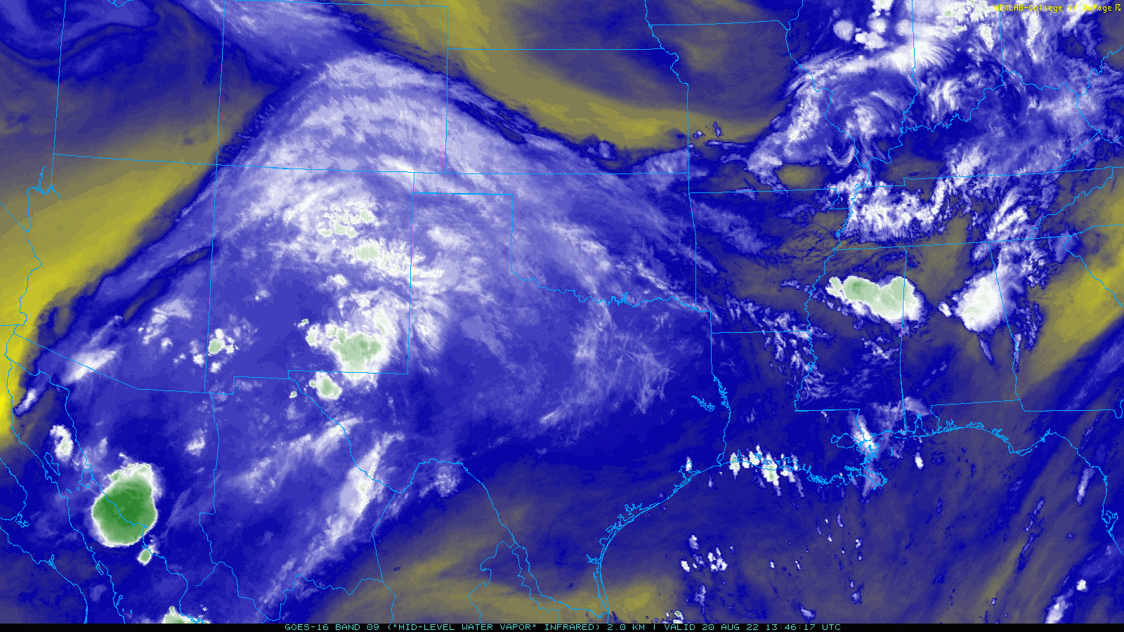
| Water vapor satellite loop valid from 8:46 am to 10:01 am on 20 August 2022. | |||||
|
The approach of an upper level storm system well to our north and northwest caused the fetch of monsoon moisture to bend squarely over West Texas, as the above satellite imagery illustrates. In addition to embedded disturbances within the monsoon, a couple of weak frontal boundaries moved southward into the region. Working together, the moisture, mid-level disturbances and low-level boundaries generated widespread showers and thunderstorms. |
|||||
 |
|||||
|
|||||
| The showers and thunderstorms initially moved across the TX/NM line Saturday morning (20 August), with additional development further east over parts of the South and Rolling Plains through the early afternoon hours. A few of the storms off the Caprock produced gusty winds, near or in excess of 50 mph, along with blowing dust. However, the increasingly tropical airmass led to very efficient rain rates and locally heavy/excessive rainfall through the evening and overnight hours. | |||||
 |
|||||
| Precipitable Water (measure of moisture in the vertical column of air, measured in inches) climatology for El Paso, Texas. The black dot represents the observed value from the sounding launched on the evening of 19 June 2022. | |||||
| The above chart is a measure of how much moisture is historically present in the air above El Paso (where our moisture was coming from on this wet weekend). It attempts to quantify how much moisture/water, in inches, is present through the depth of the air from ground level to the top of the troposphere. In essence, it is how much rain would accumulate if you could squeeze out all the moisture directly above you. Normally, this is around 1 inch in August for El Paso. However, when this measurement was taken on Friday evening (19 August) it was an incredible 1.6+ inches, a new daily record. This is the type of moisture throughout the depth of the atmosphere that is often required to produce widespread heavy rainfall. | |||||
 |
|||||
| Infrared satellite loop valid from 9:06 pm to 10:11 pm on 20 August 2022. | |||||
| The above satellite loop shows two large areas of cold cloud tops (reds and blacks) over parts of western Texas and eastern New Mexico, indicative of broad and deep thunderstorm clouds that produce very heavy rain in such a moist atmosphere. Additional t-storms and heavy rain are noted in northern Mexico, with runoff from these storms making its way into the Rio Grande via the Rio Conchos. | |||||
 |
|||||
|
|||||
|
The most widespread intense rain enveloped the South Plains region Saturday evening and continued into Sunday morning. The heaviest rain tended to target two regions, hitting the southern Texas Panhandle and northern South Plains with one "band" and the Rolling Plains with the other "band." Rainfall rates of 1 to 3 inches per hour accompanied the most intense showers and thunderstorms, which quickly added up and resulted in areas of flooding. |
|||||
 |
|||||
| Visible satellite loop valid from 1:56 pm to 3:21 pm on 21 August 2022. | |||||
| After a relative lull in activity midday Sunday (21 August), scattered showers and isolated thunderstorms reinvigorated as a surface low, seen spinning in the above animation, moved eastward across the South Plains. The showers were also enhanced along and ahead of a cold front sweeping southward through the evening hours. Although not nearly as widespread as the previous round, the more intense showers again produced torrential rainfall Sunday evening into early Monday morning, primarily near and east of the edge of the Caprock. | |||||
 |
|||||
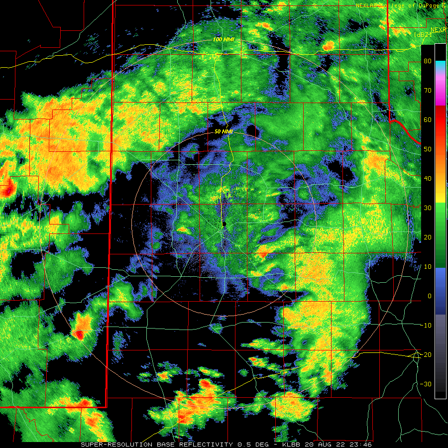
| Lubbock WSR-88D radar animation valid from 1:19 pm to 9:25 pm on 21 August 2022. An additional radar animation valid from 5:51 pm on 21 August to 9:46 am on 22 August 2022 can be VIEWED HERE. | |||||
|
Widely scattered showers persisted through much of the day Monday, though additional rain totals were light. In addition to the widespread rain, the clouds and precipitation helped keep high temperatures down in the 70s and lower 80s as most spots, with some locations not even making it out of the 60s. |
|||||
 |
|||||
| 3-day rain totals ending at 7 am on Monday, 22 August 2022. | |||||
|
All told, much of the region received 1 to 3+ inches of rain over the relatively cool, humid and wet weekend, as the above 3-day rain totals show. The heaviest rain, from 3 to 5+ inches, fell in a swath from near Pep through Olton, with similar amounts falling over much of Cottle County and adjacent spots. The relative minimum, under an inch, occurred from the southwest into the central South Plains, roughly from Plains to Lubbock. Even here, most spots did record a half inch or more. The widespread significant rain did put water into the intermittent streams of West Texas, boost reservoirs modestly and help temper the ongoing drought, though more widespread rain will be needed to ameliorate the drought altogether. Preliminary rainfall and flooding reports collected during this wet mid-August stretch can be found below: |
Public Information Statement
National Weather Service Lubbock TX
137 PM CDT Mon Aug 22 2022

...PRECIPITATION REPORTS...

Location                     Amount    Time/Date       Lat/Lon

...Texas...

...Bailey County...
MULESHOE NWR MULESHOE 19 S   3.69 in   0110 PM 08/22   33.96N/102.78W
1.8 SW Muleshoe              1.80 in   0100 PM 08/22   34.21N/102.74W
Muleshoe 1.2 N               1.76 in   0850 AM 08/21   34.25N/102.72W
0.7 SW Muleshoe              1.74 in   0700 AM 08/22   34.22N/102.73W
1.6 W Muleshoe Wildlife Refu 0.95 in   0800 AM 08/21   33.96N/102.78W

...Briscoe County...
Silverton                    4.00 in   0800 AM 08/22   34.47N/101.31W
Quitaque 3 N                 2.65 in   1000 AM 08/22   34.41N/101.07W
Caprock                      2.44 in   0807 AM 08/22   34.41N/101.05W
6.7 E Silverton              2.13 in   0100 PM 08/22   34.45N/101.19W
Silverton 5.0 E              2.04 in   0700 AM 08/22   34.47N/101.22W
0.6 E Mackenzie Reservoir    2.01 in   1230 PM 08/22   34.55N/101.44W

...Castro County...
1.1 S Hart                   4.36 in   0700 AM 08/22   34.37N/102.12W
2.6 N Hart                   3.01 in   0100 PM 08/22   34.42N/102.11W
2.6 N Dimmitt                1.95 in   0737 AM 08/22   34.59N/102.31W
Dimmitt 2NE                  1.72 in   0100 PM 08/22   34.57N/102.29W

...Childress County...
Childress 2.3 E              3.07 in   0750 AM 08/22   34.42N/100.21W
2.8 S Tell                   2.61 in   0700 AM 08/22   34.34N/100.40W
Childress                    2.32 in   1253 PM 08/22   34.43N/100.28W
3.6 NE Childress             2.17 in   0100 PM 08/22   34.46N/100.20W
7.2 NW Childress             1.65 in   0800 AM 08/22   34.52N/100.29W
2.2 E Childress              0.85 in   0700 AM 08/22   34.42N/100.21W

...Cochran County...
Morton                       1.75 in   0800 AM 08/22   33.72N/102.76W
1.3 NE Morton                1.36 in   0100 PM 08/22   33.73N/102.74W

...Cottle County...
Paducah 10 S                 4.59 in   0700 AM 08/22   33.88N/100.39W
Matador                      3.43 in   0103 PM 08/22   34.12N/100.34W

...Crosby County...
0.9 SE Ralls                 2.07 in   0100 PM 08/22   33.67N/101.38W
Lubbock                      1.76 in   0800 AM 08/22   33.65N/101.49W
1.8 SE White River Lake      1.31 in   1200 PM 08/22   33.46N/101.08W
Crosbyton 1 SW               1.30 in   0700 AM 08/22   33.65N/101.25W
4.9 NW White River Lake      0.92 in   0100 PM 08/22   33.53N/101.17W

...Dickens County...
1.2 W Spur                   3.07 in   0700 AM 08/22   33.48N/100.88W
1.2 W Spur                   1.81 in   0100 PM 08/22   33.48N/100.88W
Dickens 2.4 SW               1.64 in   0600 AM 08/22   33.59N/100.86W

...Floyd County...
Floydada                     1.23 in   0116 PM 08/22   34.14N/101.19W
Floydada                     1.21 in   0700 AM 08/22   33.98N/101.33W
Floydada 9 SE                1.16 in   0700 AM 08/22   33.88N/101.25W
Amarillo                     1.14 in   1050 AM 08/22   34.07N/101.07W
9.2 N Petersburg             1.09 in   1245 PM 08/22   34.00N/101.55W
1.4 NE Floydada              1.09 in   0100 PM 08/22   34.00N/101.33W

...Garza County...
Justiceburg 2.4 ENE          2.12 in   0700 AM 08/22   33.05N/101.16W
Justiceburg                  2.04 in   0115 PM 08/22   33.03N/101.15W
Lake Alan Henry              1.97 in   1230 PM 08/22   33.06N/101.05W
1.0 NE Post                  1.10 in   0100 PM 08/22   33.20N/101.37W
5.5 SW Graham                1.06 in   0100 PM 08/22   33.08N/101.52W
0.7 NE Post                  0.92 in   0557 AM 08/22   33.20N/101.37W
Justiceburg                  0.65 in   0100 PM 08/22   33.04N/101.20W

...Hale County...
1.6 N Plainview              2.49 in   0730 AM 08/22   34.21N/101.72W
1.2 E Plainview              1.94 in   0800 AM 08/22   34.19N/101.70W
1.3 SE Plainview             1.94 in   0100 PM 08/22   34.18N/101.71W
Plainview                    1.79 in   0115 PM 08/22   34.17N/101.72W
Hale Center                  1.74 in   0120 PM 08/22   34.07N/101.85W
5.7 E Abernathy              1.30 in   0100 PM 08/22   33.88N/101.76W
Abernathy                    1.29 in   0649 AM 08/22   33.84N/101.85W
Abernathy 3.2 NNW            1.14 in   0700 AM 08/22   33.88N/101.86W

...Hall County...
2.3 SW Turkey                2.26 in   1000 AM 08/22   34.38N/100.93W
0.9 E Memphis                1.66 in   1000 AM 08/22   34.73N/100.53W
6.4 SW Brice                 1.20 in   0100 PM 08/22   34.63N/100.94W
Turkey 1 NNW                 0.98 in   0800 AM 08/21   34.40N/100.90W

...Hockley County...
6.2 S Anton                  0.78 in   0100 PM 08/22   33.73N/102.19W

...Kent County...
1.3 S Jayton                 1.47 in   1000 AM 08/22   33.23N/100.57W
Jayton                       1.46 in   1046 AM 08/22   33.23N/100.57W

...King County...
Paducah 15 S                 4.25 in   0600 AM 08/22   33.81N/100.30W
10.0 W Guthrie               1.60 in   1000 AM 08/22   33.57N/100.48W
0.8 W Guthrie                1.32 in   0800 AM 08/22   33.63N/100.34W

...Lamb County...
Olton 0.2 W                  5.09 in   0700 AM 08/22   34.18N/102.14W
4.4 S Earth                  3.14 in   1000 AM 08/22   34.17N/102.40W
Littlefield 5 SE             2.08 in   0800 AM 08/21   33.87N/102.26W

...Lubbock County...
Shallowater 2.0 W            1.15 in   0700 AM 08/22   33.69N/102.03W
Lubbock 13.2 N               1.12 in   0700 AM 08/22   33.77N/101.88W
Lubbock                      1.09 in   1046 AM 08/22   33.58N/101.88W
Shallowater 0.4 ESE          0.97 in   0700 AM 08/22   33.69N/101.99W
Shallowater                  0.97 in   0700 AM 08/22   33.69N/101.99W
1.6 NW Reese Center          0.93 in   0100 PM 08/22   33.61N/102.05W
Lubbock 3.9 NW               0.92 in   0700 AM 08/22   33.61N/101.93W
Lubbock 4.7 WNW              0.89 in   0730 AM 08/22   33.59N/101.95W
2.5 E Reese Center           0.89 in   0730 AM 08/22   33.59N/101.98W
Shallowater 2.7 NW           0.83 in   0700 AM 08/22   33.72N/102.03W
1.9 NW Texas Tech Univ.      0.83 in   0100 PM 08/22   33.60N/101.90W
Lubbock                      0.82 in   1253 PM 08/22   33.67N/101.82W
Lubbock 3.1 S                0.78 in   0700 AM 08/22   33.53N/101.88W
2 NNW Lubbock South Plains M 0.78 in   0115 PM 08/22   33.57N/101.93W
Lubbock 5.3 SSW              0.74 in   0800 AM 08/22   33.51N/101.93W
Slide 0.6 SSW                0.68 in   0800 AM 08/22   33.40N/101.94W
Lubbock                      0.68 in   1048 AM 08/22   33.52N/101.96W
Lubbock 6.4 SW               0.67 in   0700 AM 08/22   33.52N/101.96W
Lubbock 9.1 NNW              0.65 in   0700 AM 08/22   33.70N/101.94W
Lubbock 5.6 S                0.59 in   0800 AM 08/22   33.50N/101.89W
Lubbock 6.4 NW               0.57 in   0700 AM 08/22   33.64N/101.96W
2 ESE Lubbock South Plains M 0.55 in   0900 AM 08/22   33.52N/101.88W

...Lynn County...
3.1 N Tahoka                 1.00 in   0100 PM 08/22   33.21N/101.78W
0.5 NW Tahoka                0.98 in   0700 AM 08/22   33.17N/101.80W
3.0 W Southland              0.87 in   0845 AM 08/22   33.37N/101.60W

...Motley County...
Roaring Springs 0 S          2.67 in   0730 AM 08/22   33.90N/100.86W
2.6 N Roaring Springs        2.32 in   0100 PM 08/22   33.94N/100.85W
1.9 E Flomot                 2.18 in   0800 AM 08/22   34.23N/100.96W
1.8 S Northfield             2.09 in   0700 AM 08/22   34.26N/100.60W
Matador 1 NE                 1.79 in   0800 AM 08/22   34.02N/100.81W

...Parmer County...
8.9 NW Lazbuddie             1.90 in   1245 PM 08/22   34.47N/102.73W
2.1 NE Friona                1.69 in   0100 PM 08/22   34.65N/102.69W
0.7 E Friona                 1.63 in   0700 AM 08/22   34.64N/102.71W
Friona 0.8 W                 1.51 in   0700 AM 08/22   34.64N/102.74W

...Stonewall County...
Aspermont 1 NW               2.27 in   0700 AM 08/22   33.15N/100.23W
2.6 NE Aspermont             1.87 in   0100 PM 08/22   33.17N/100.20W

...Swisher County...
0.9 NE Tulia                 2.49 in   0700 AM 08/22   34.55N/101.76W
Vigo Park                    1.72 in   0800 AM 08/22   34.65N/101.50W

...Terry County...
0.8 N Brownfield             1.03 in   0730 AM 08/22   33.19N/102.27W
1.9 S Brownfield             0.55 in   0100 PM 08/22   33.15N/102.27W

...Yoakum County...
6.9 NE Higginbotham          1.39 in   0100 PM 08/22   32.99N/102.94W

Observations are collected from various sources, including ASOS, AWOS,
West Texas Mesonet, COOP,  and CoCoRaHS, with varying equipment and
exposures. We thank all volunteer weather observers for their dedication.
Not all data listed are considered official.

