|
Late May and early June bring widespread rain to West Texas |
|||||
 |
|||||
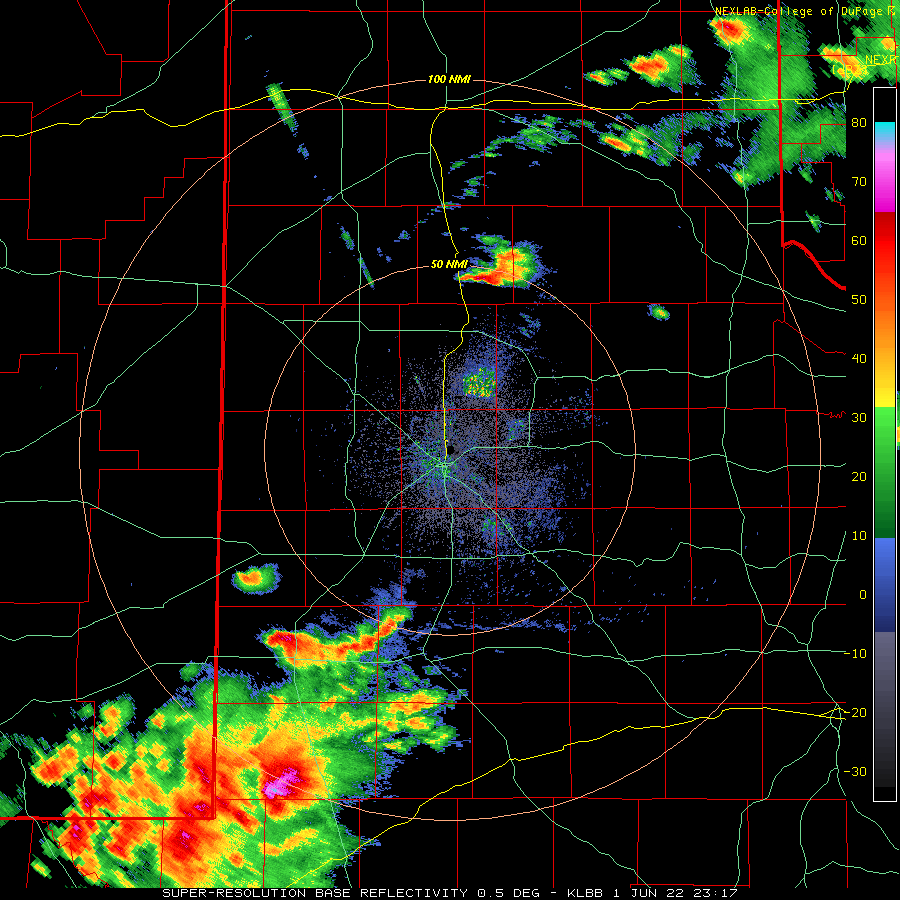
| Lubbock WSR-88D radar animation valid from 7:37 pm to 9:54 pm on 1 June 2022. An additional radar animation can be viewed at: 6:17 pm to 9:54 pm on the 1st. | |||||
|
Several rounds of showers and thunderstorms affected West Texas during the very end of May into the first few days of June 2022. The active weather kicked off on May 31st, when a stationary front combined with plenty of heat, moisture and instability to bring severe weather and widespread heavy rain to the south-central and southeast Texas Panhandle and adjacent areas of the South Plains and Rolling Plains. A detailed discussion of the active last day of May can be FOUND HERE. |
|||||
 |
|||||
|
|||||
|
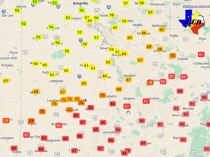
The following days, into early June, brought cooler temperatures and additional rounds of thunderstorms. The front that sparked the activity on May 31st moved through the South Plains region on June 1st, providing the much cooler air on gusty northerly winds. Low clouds also filled in behind the front, which further intensified the temperature gradient Wednesday afternoon. As the above plot shows, temperatures ranged from the lower and middle 50s across the western Texas Panhandle to the upper 80s and lower 90s across the southern South and Rolling Plains Wednesday afternoon, as the front was moving through. |
|||||
 |
|||||
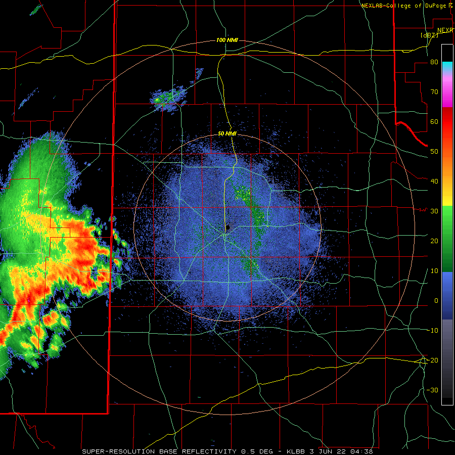
| Lubbock WSR-88D radar animation valid from 11:38 pm on the 2nd to 7:22 am on 3 June 2022. | |||||
|
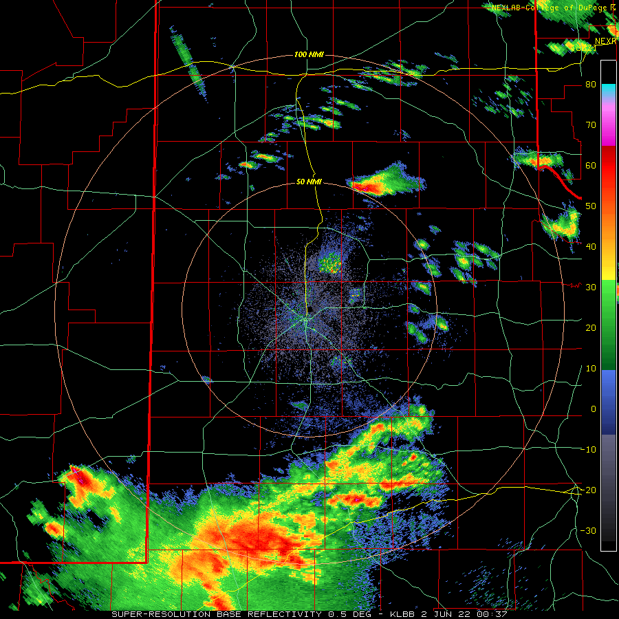
The front was located south of the area, in the Permian Basin, by late in the day Wednesday, which helped focus the severe weather there during the late afternoon and early evening hours. However, additional isolated to scattered strong to severe thunderstorms developed well north of the front, late Wednesday evening (see the radar animation at the top of this page). The most intense of these storms generated very heavy rain and large hail, as big as baseballs in Matador. |
|||||
 |
|||||
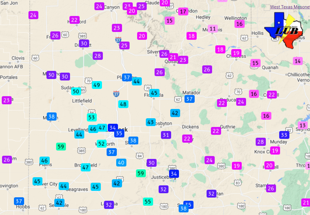
| Maximum wind gusts recorded by the West Texas Mesonet early Friday morning (3 June 2022). | |||||
| The next day, Thursday (June 2nd), was mostly cloudy and relatively cool for early June as highs only reached the 70s in most spots. These cool conditions kept storms from developing in the area during the afternoon. Instead, thunderstorms developed over the higher terrain of eastern New Mexico, where they experienced more sunshine. This activity gradually organized into a larger complex as it accelerated eastward Thursday evening and into the overnight hours. This system did generate gusty winds, mostly in the 40 to 55 mph range, as it moved across the western and central South Plains early Friday morning. | |||||
 |
|||||
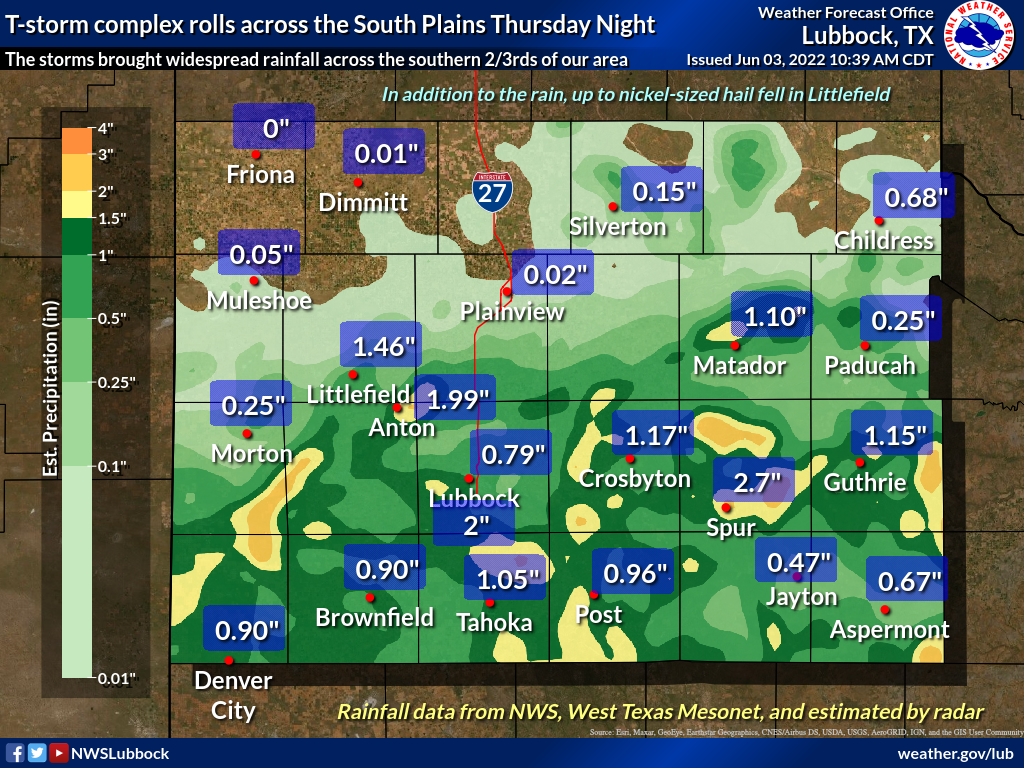
| Rain totals, as measured by the West Texas Mesonet and the National Weather Service, from Thursday night into Friday morning (2-3 June 2022). The background map is the radar-estimated and bias-corrected rainfall over the same period. | |||||
| More importantly, widespread rain fell across much of the South and Rolling Plains Friday morning. Rain totals near and above 1 inch were common for a large portion of the central and southern South and Rolling Plains. | |||||
 |
|||||
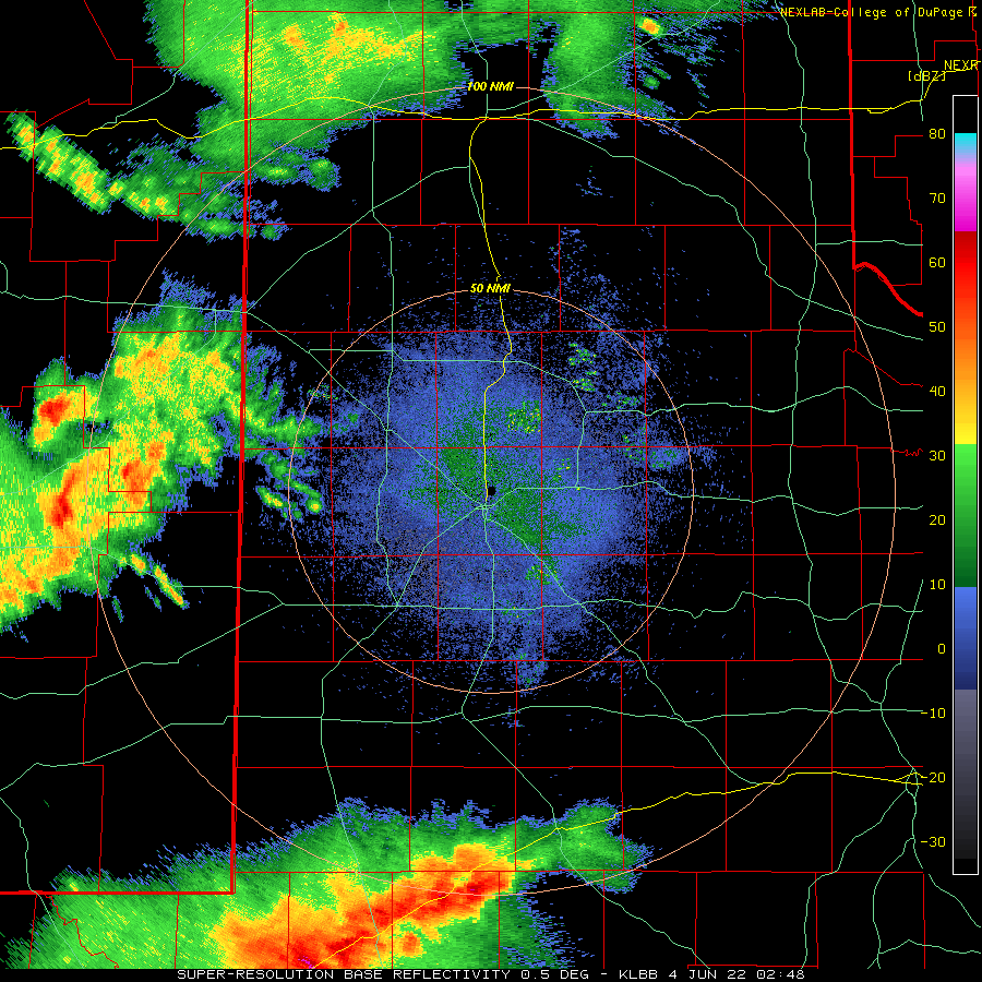
| Lubbock WSR-88D radar animation valid from 9:48 pm on the 3rd to 8:05 am on 4 June 2022. | |||||
| Quiet conditions were common Friday afternoon, but one final round of showers and thunderstorms impacted the region late Friday evening into early Saturday morning (3-4 June). This time the southwestern South Plains and southern Rolling Plains received the bulk of the precipitation. | |||||
 |
|||||
|
|||||
|
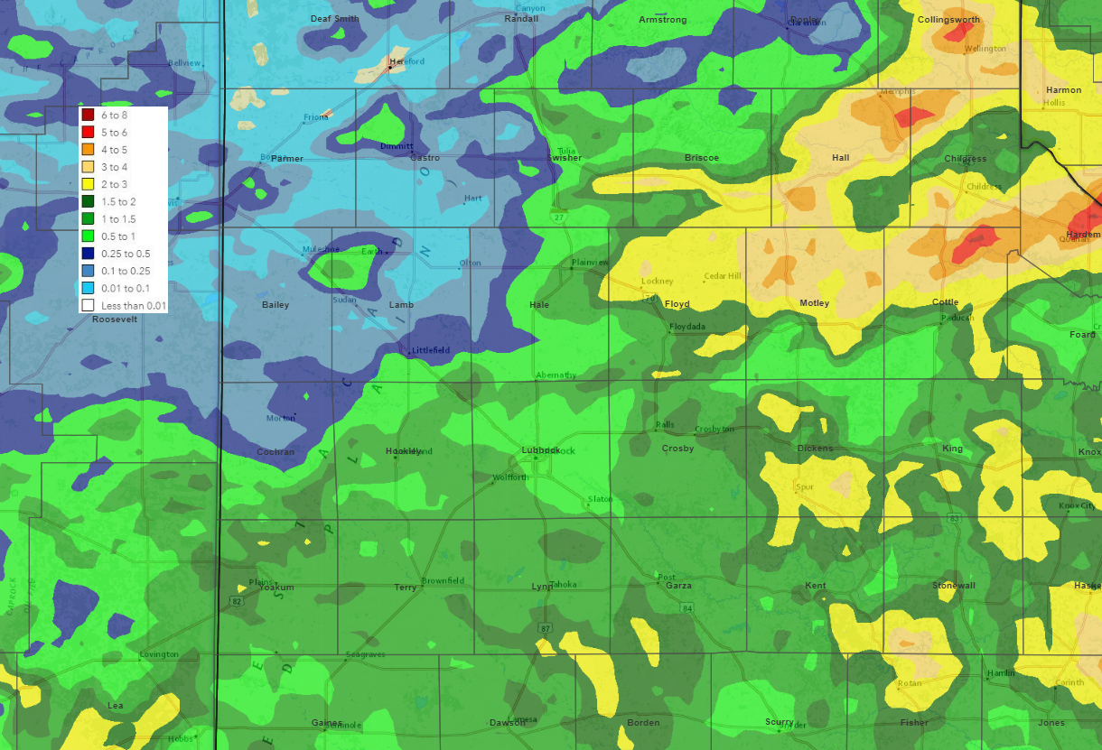
In total, over the unsettled stretch, widespread significant rain fell on the region. The heaviest rain, from 1 to 3+ inches, was common over roughly the southeast 2/3rds of the South Plains, the southeast Texas Panhandle and much of the Rolling Plains. Officially, the Lubbock Airport recorded 0.80 inches, though much of the city proper received 1 to 2 inches. Childress officially recorded 2.29 inches over this same stretch. The widespread rain helped to further ease the ongoing drought, though unfortunately the northwest South Plains and southwest Texas Panhandle largely missed out on the heaviest of the rain.
The preliminary storm reports collected by NWS Lubbock over this unsettled period can be viewed below: |
|||||
PRELIMINARY LOCAL STORM REPORT...SUMMARY
NATIONAL WEATHER SERVICE LUBBOCK TX
339 AM CDT WED JUN 01 2022

..TIME...   ...EVENT...      ...CITY LOCATION...     ...LAT.LON...
..DATE...   ....MAG....      ..COUNTY LOCATION..ST.. ...SOURCE....
            ..REMARKS..

0449 PM     HAIL             3 SE MEMPHIS            34.69N 100.50W
05/31/2022  M3.50 INCH       HALL               TX   STORM CHASER

            PHOTO FROM SOCIAL MEDIA SHOWING A HAILSTONE MEASURED
            APPROXIMATELY 20 MINUTES AFTER THE CORE WENT THROUGH
            THIS AREA. NUMEROUS VEHICLES HAVE HAD WINDSHIELDS BUSTED
            OUT ON US 287 AS WELL.

0504 PM     HAIL             5 E MEMPHIS             34.73N 100.45W
05/31/2022  M2.50 INCH       HALL               TX   STORM CHASER

            AVERAGE HAILSTONES WERE 2" IN DIAMETER BUT A FEW UP TO
            2.5" IN DIAMETER.

0554 PM     HAIL             MEMPHIS                 34.73N 100.54W
05/31/2022  M2.00 INCH       HALL               TX   EMERGENCY MNGR

0642 PM     HAIL             TULIA                   34.54N 101.77W
05/31/2022  E1.75 INCH       SWISHER            TX   PUBLIC

            SOCIAL MEDIA PHOTO OF GOLF BALL SIZED HAIL.

0646 PM     HAIL             6 E NEWLIN              34.60N 100.33W
05/31/2022  E1.50 INCH       CHILDRESS          TX   CO-OP OBSERVER

            LARGEST HAIL WAS PING PONG SIZED

0731 PM     HAIL             7 ESE TULIA             34.50N 101.66W
05/31/2022  E2.00 INCH       SWISHER            TX   STORM CHASER

0807 PM     FLASH FLOOD      1 S PLASKA              34.59N 100.65W
05/31/2022                   HALL               TX   EMERGENCY MNGR

            A PORTION OF FM 2472 NEAR PLASKA HAS BEEN WASHED OUT
            FROM THE HEAVY RAINFALL.

0811 PM     HAIL             SILVERTON               34.47N 101.30W
05/31/2022  E2.75 INCH       BRISCOE            TX   FIRE DEPT/RESCUE

            SEVERAL WINDSHIELDS REPORTED BROKEN AS WELL.

0815 PM     FLASH FLOOD      5 SE MEMPHIS            34.67N 100.48W
05/31/2022                   HALL               TX   LAW ENFORCEMENT

            US 287 NEAR FM 1619 IS FLOODED.

0817 PM     FLASH FLOOD      2 SW MEMPHIS            34.71N 100.56W
05/31/2022                   HALL               TX   TX DOT

            A PORTION OF FM 1041 WAS REPORTED WASHED OUT NEAR
            HIGHWAY 256 DUE TO THE HEAVY RAINFALL.

1010 PM     HAIL             PLAINVIEW               34.19N 101.72W
05/31/2022  M1.50 INCH       HALE               TX   SOCIAL MEDIA

            PHOTO OF PING PONG BALL SIZED HAIL SHARED ON TWITTER.

1014 PM     HAIL             PLAINVIEW               34.19N 101.72W
05/31/2022  E2.00 INCH       HALE               TX   BROADCAST MEDIA

1022 PM     HAIL             LOCKNEY                 34.12N 101.44W
05/31/2022  E1.75 INCH       FLOYD              TX   BROADCAST MEDIA

1225 AM     HAIL             1 NE MATADOR            34.02N 100.81W
06/01/2022  E1.75 INCH       MOTLEY             TX   CO-OP OBSERVER

            MOST HAIL STONES WERE THE SIZE OF QUARTERS, BUT LARGEST
            WERE GOLFBALLS.

1257 AM     HAIL             FLOYDADA                33.98N 101.34W
06/01/2022  E1.00 INCH       FLOYD              TX   LAW ENFORCEMENT

            BROADCAST MEDIA ALSO RELAYED REPORT OF QUARTER SIZE
            HAIL IN FLOYDADA.

0109 AM     HAIL             9 SE FLOYDADA           33.89N 101.23W
06/01/2022  E1.75 INCH       FLOYD              TX   CO-OP OBSERVER

0134 AM     TSTM WND GST     2 W CHILDRESS           34.43N 100.28W
06/01/2022  M61 MPH          CHILDRESS          TX   ASOS

