|
Tornadic storm, damaging winds and widespread rain |
|||
 |
|||
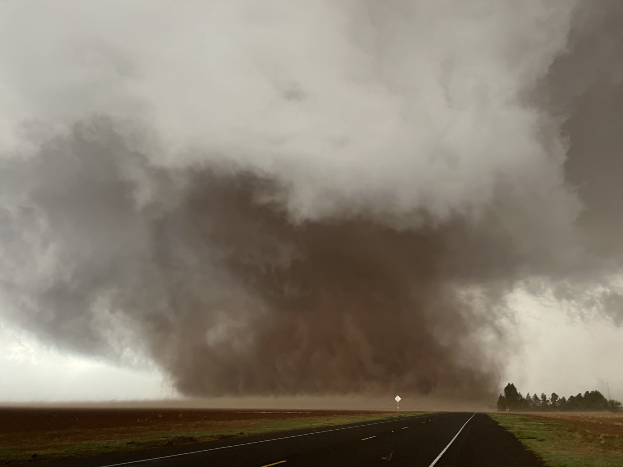
| Large, dusty tornado north of Morton on Monday evening (23 May 2022). The picture is courtesy of Kholby Martin. | |||
|
May 23rd and 24th brought several rounds of thunderstorms, complete with tornadoes, damaging winds, hail and widespread rain, to the South Plains region of West Texas. The activity was fueled by returning Gulf moisture following a strong May front that provided a relatively cool and dry weekend leading up to the stormy stretch. Moderate to strong instability developed across the western South Plains and eastern New Mexico Monday afternoon and evening (May 23rd) as the improving low-level moisture and temperatures warming into the 80s developed beneath an approaching upper level storm system. |
|||
 |
|||
|
|||
|
In response to the approaching disturbance and improving moisture, scattered thunderstorms quickly developed near the Texas/New Mexico state line late Monday afternoon. Relatively strong wind shear (changing wind speed and direction with height) caused several of the thunderstorms to rotate as they moved into the western South Plains and western Texas Panhandle Monday evening. |
|||
 |
|||
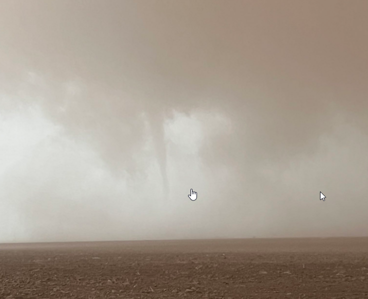
| Narrow funnel (possible tornado) northwest of Morton Tuesday evening (23 May 2022). The image is courtesy of Russ Smith. | |||
|
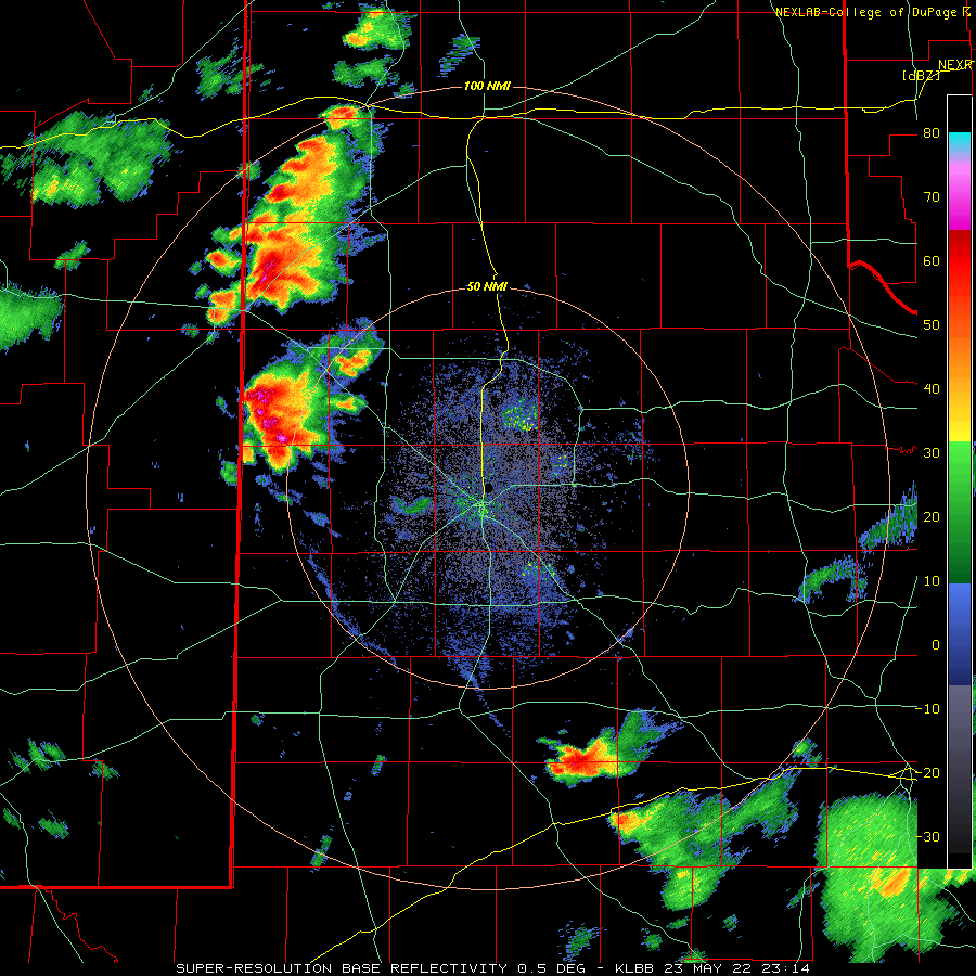
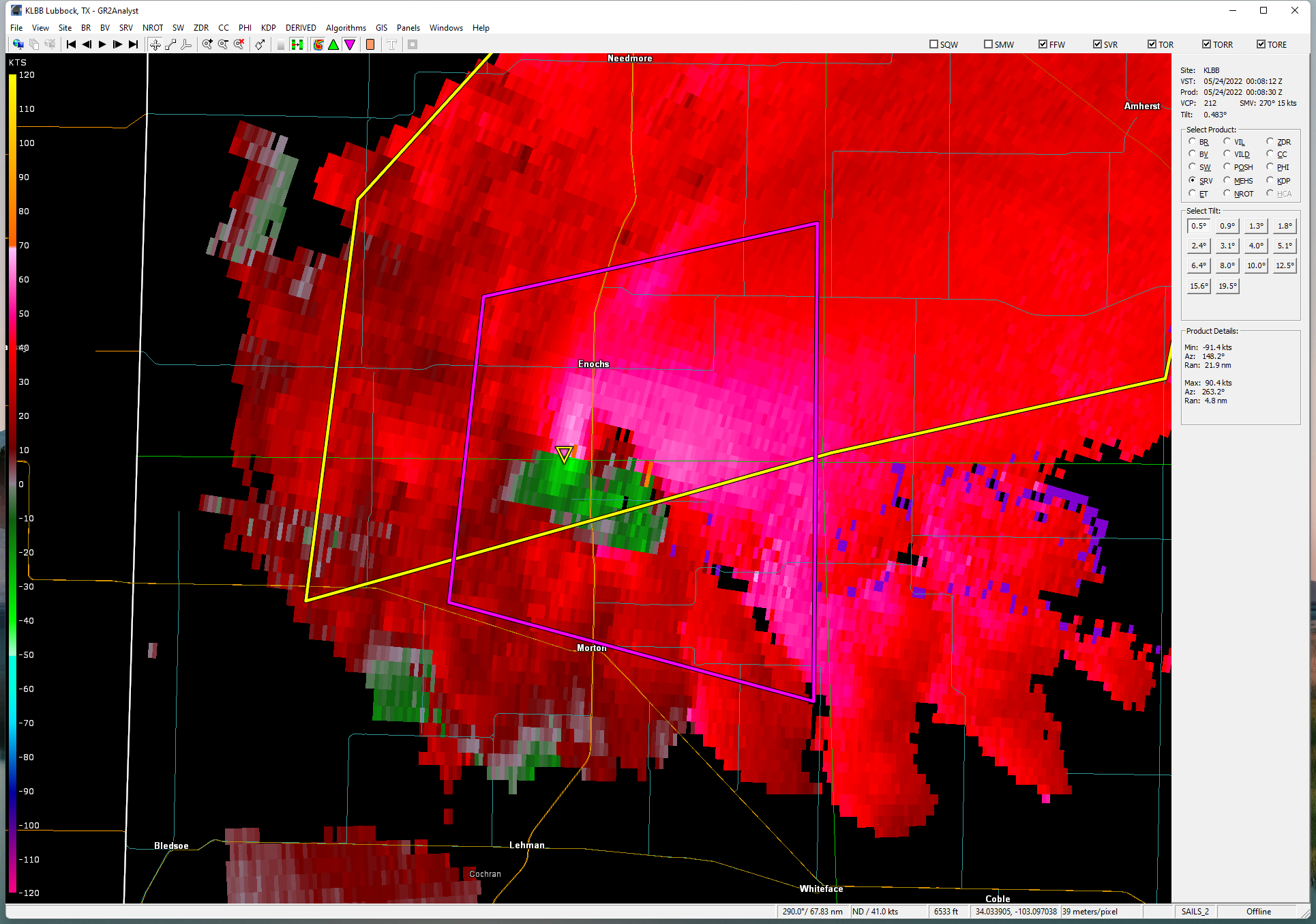
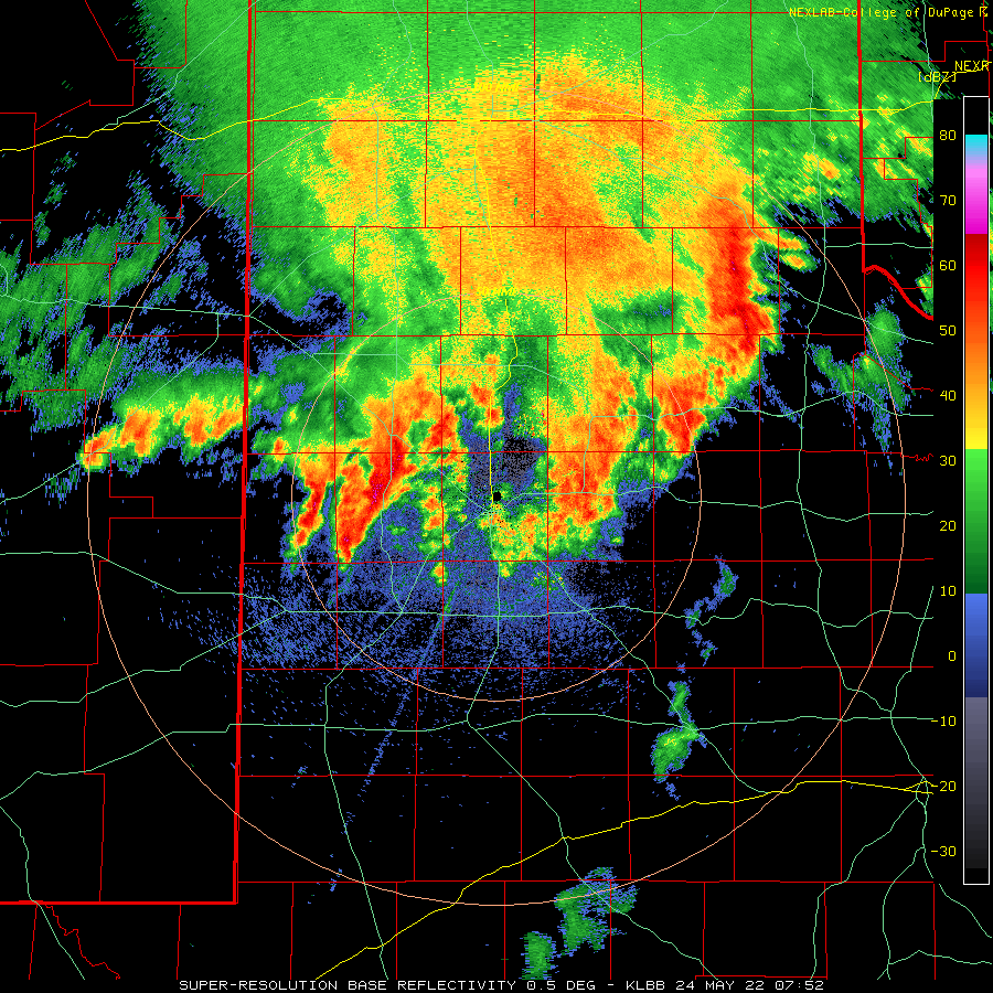
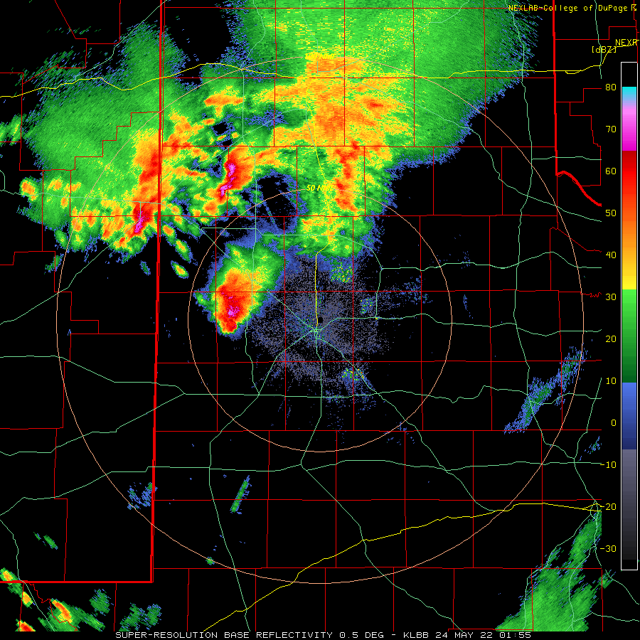
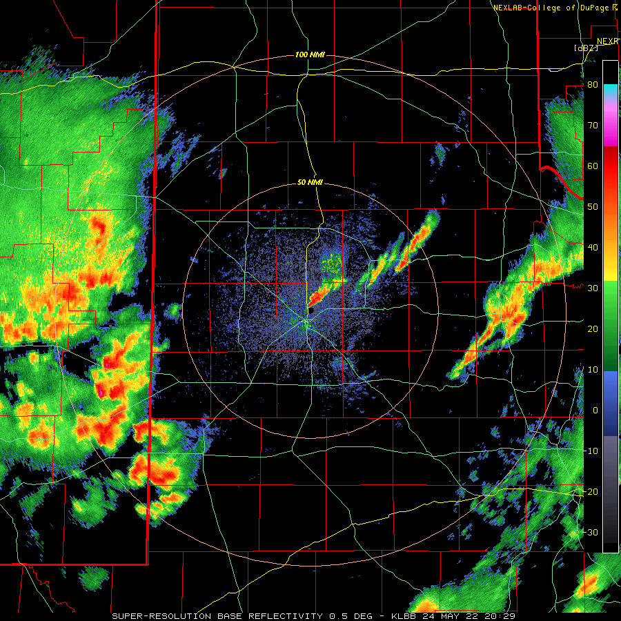
The most intense activity of the day was a cyclonically rotating storm that organized over southern Bailey County, then slowed and tracked east and southeastward through parts of Cochran and Hockley Counties Monday evening. This storm produced its first observed tornado, a brief one, northwest of Morton just before 7 pm. The storm further strengthened, and went on to produce a large tornado north of Morton shortly after 7 pm. The below radar imagery shows what the storm looked like around the time it was producing a large and dusty tornado. |
|||
 |
 |
||
| Lubbock WSR-88D 0.5 degree reflectivity (left) and velocity (right) data valid at 7:08 pm on 23 May 2022. | |||
|
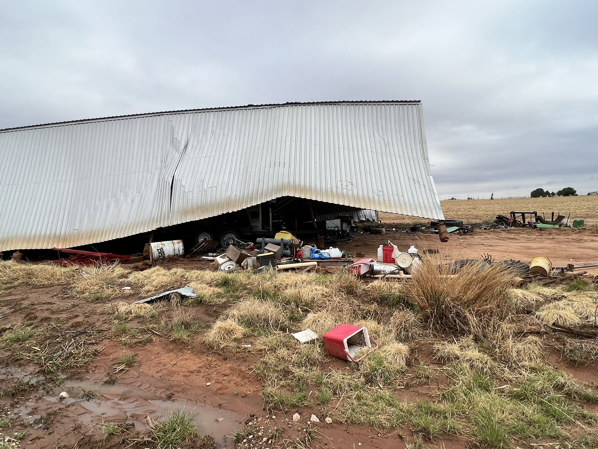
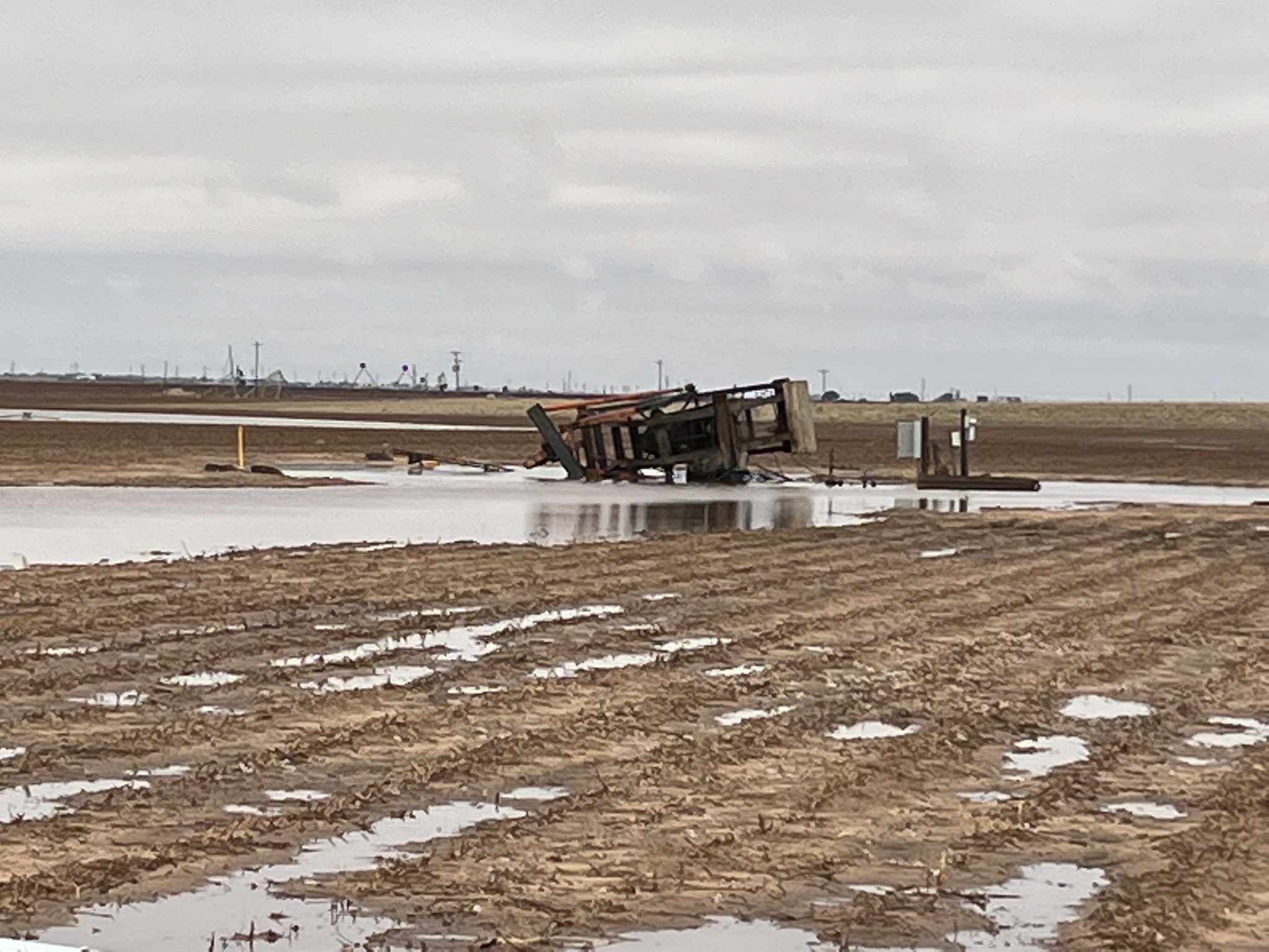
The slow-moving storm went on to produce at least three additional tornadoes as it crept into Hockley County through the mid-late evening hours. Thankfully, the tornadoes occurred over rural areas, which limited the overall impacts. However, spotty damage did occur, including two oil derricks that were toppled by the intense tornadic winds. This damage, along with snapped power poles and flipped center pivots, earned a peak damage rating of EF-2. A few of the tornadoes inflicted no known damage and were rated EFU. A total of at least 8 tornadoes were documented with this storm from shortly before 7 pm to around 9 pm. See the Public Information Statement (PNS) at the bottom of this page for details from the damage survey conducted the day after the tornadoes. |
|||
 |
 |
||
| Barn (left) and oil derrick (right) damaged by the tornadic storm that passed north of Morton Monday evening (23 May 2022). The left picture is courtesy of Ronda Turnbowz and the right picture is courtesy of Shelly@ttushell. | |||
|
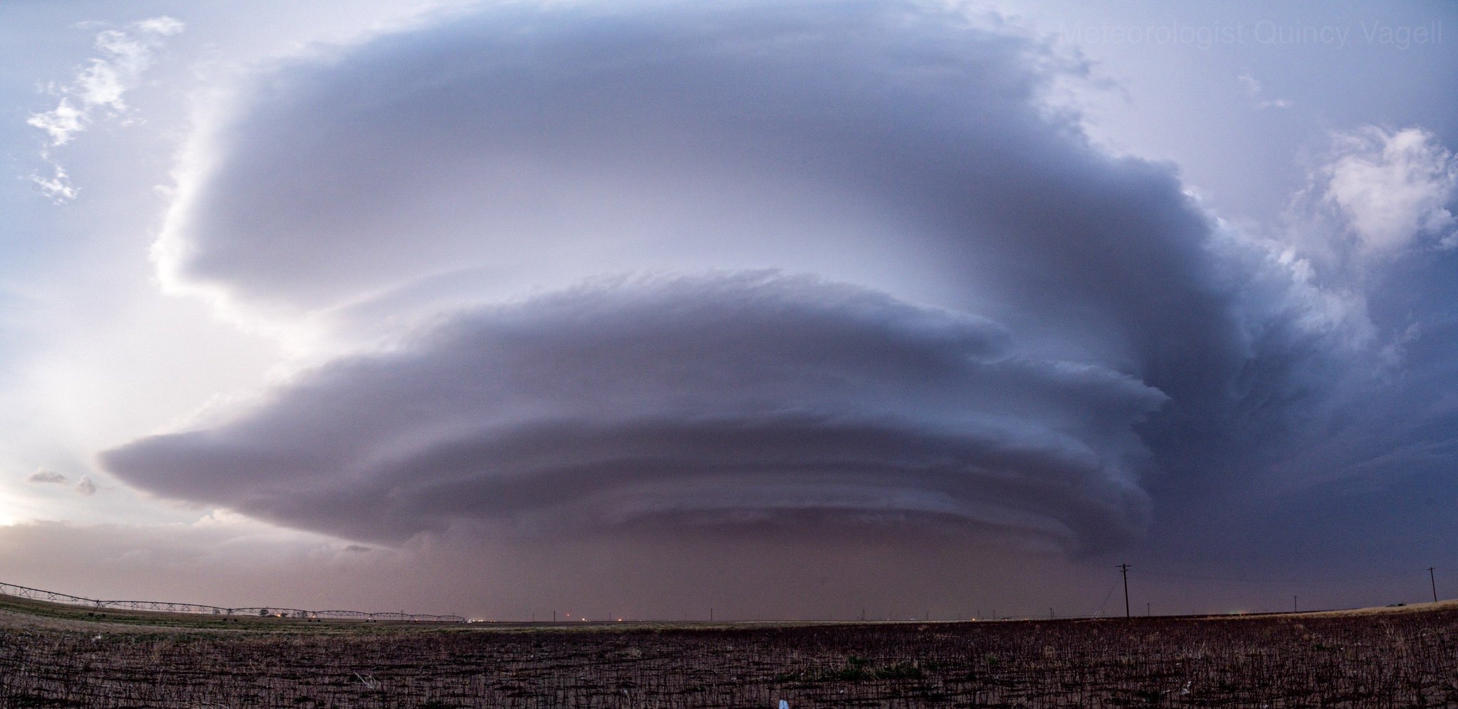
As the storm plodded eastward, it gradually weakened, but still generated damaging winds, hail and torrential rainfall. In addition, it created an ominous site as it approached (see the image below). |
|||
 |
|||
| Supercell (rotating) thunderstorm near Levelland Monday evening (23 May 2022). The picture is courtesy of Quincy Vagell. | |||
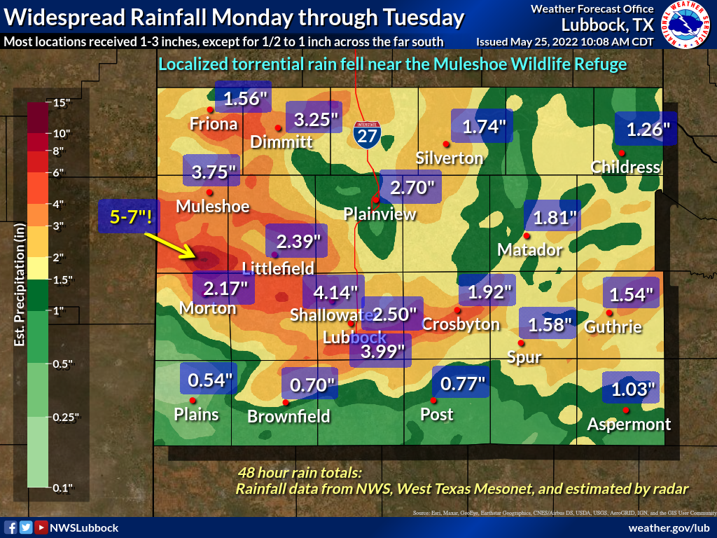
| The thunderstorms eventually evolved into a larger complex that brought widespread rain to most of the South Plains, Rolling Plains and southern Texas Panhandle from Monday evening through Tuesday morning. The heaviest rain over this stretch was associated with the slow-moving tornadic storm Monday evening, and was concentrated over Bailey County, where 3 to as much as 7 inches of rain fell. | |||
 |
|||
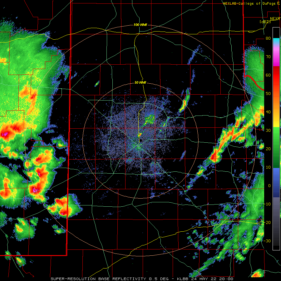
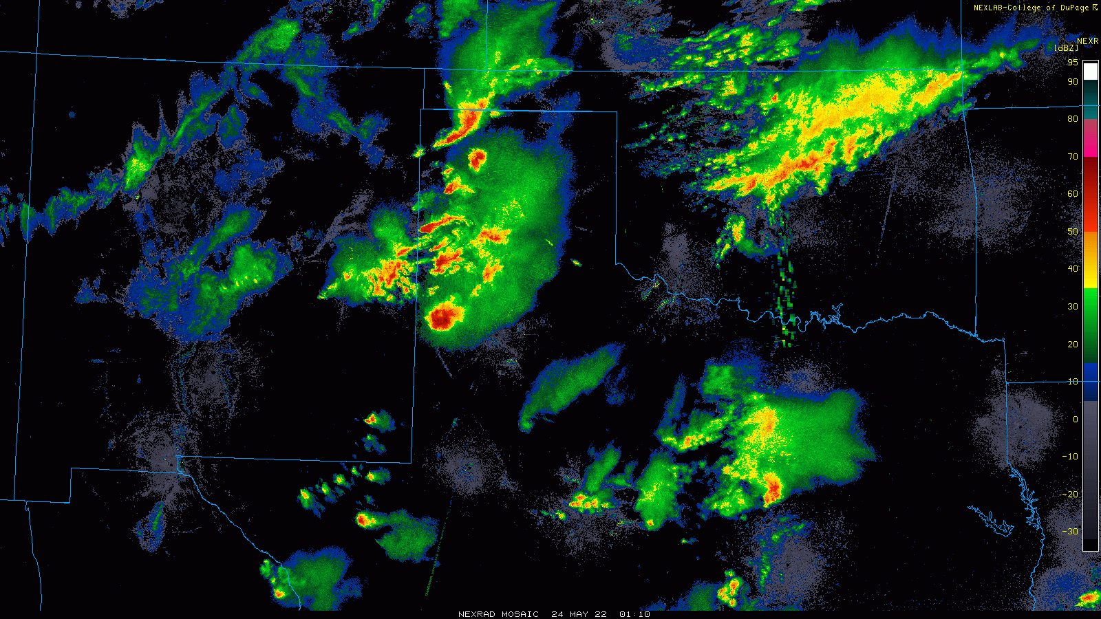
| Lubbock WSR-88D radar animation valid from 2:52 am to 6:20 am on 24 May 2022. | |||
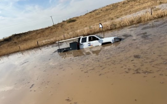
| The intense and excessive rainfall flooded out many roadways in Bailey County, especially south of Muleshoe. The heaviest rain was concentrated over the southeast portion of Bailey County, from near the Muleshoe Wildlife Refuge to Enoch then eastward to immediately northwest of Pep. | |||
 |
|||
| Flooded out truck south of Muleshoe Tuesday morning (24 May 2022). The picture is courtesy of Ricky Carrillo. | |||
| After a brief reprieve around midday Tuesday (May 24th), another batch of thunderstorms originating from the higher terrain of eastern New Mexico swept through the region. This complex of thunderstorms moved much more quickly than the previous evening's storms, though additional slow-moving storms also formed along a weak frontal zone over the central South Plains late Tuesday afternoon. | |||
 |
|||
|
|||
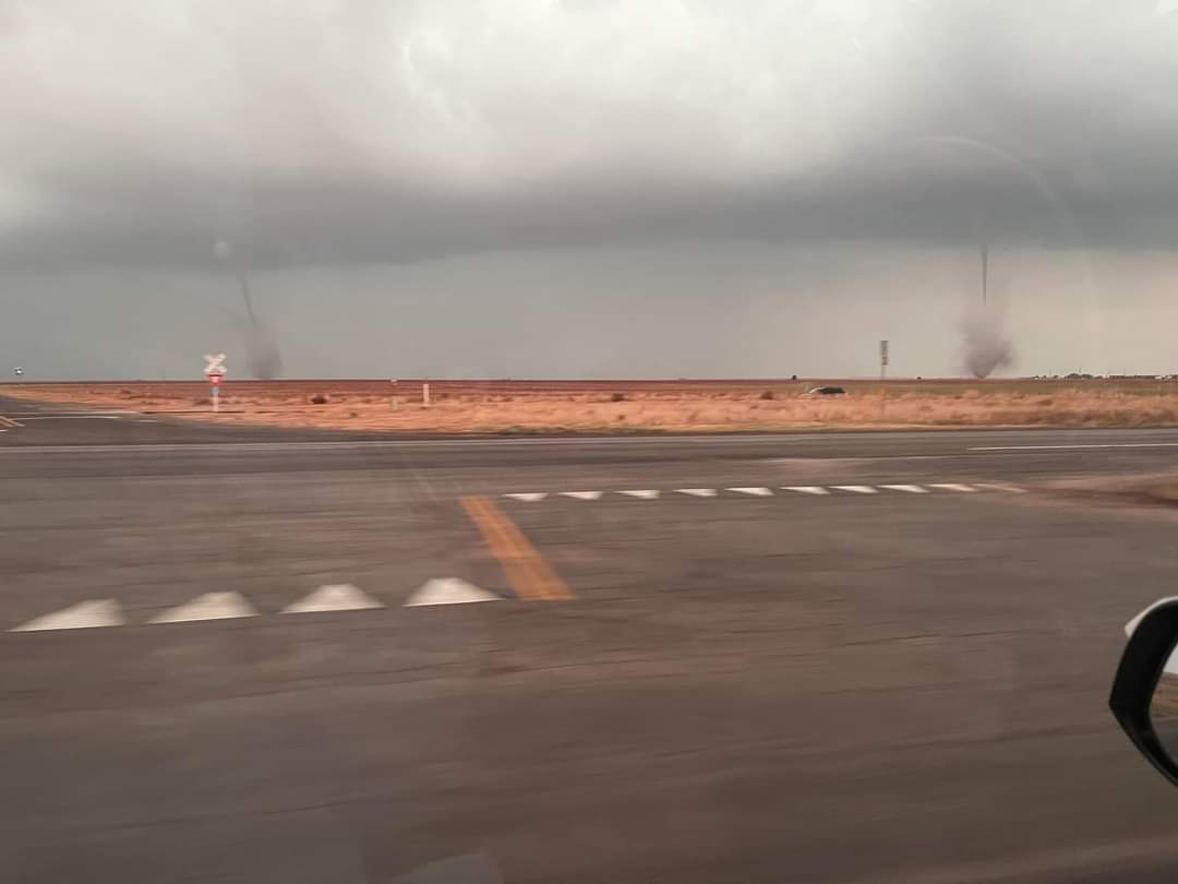
| The thunderstorms that formed above the quasi-stationary frontal zone were able to concentrate the spin along the front, which resulted in the development of several landspout type tornadoes. These tornadoes are generally short-lived and weak, but quite visible and photogenic (as seen below). A one point as many as three landspouts were observed at the same time near the community of Meadow. Thankfully, the landspouts moved very little, dissipated relatively quickly and inflicted little to no known damage. However, the slow-moving line of thunderstorms dropped torrential rainfall, as much as 2-3+ inches, over southern Lubbock into central Crosby Counties, creating flash flooding. | |||
 |
|||
| A pair of landspout tornadoes near Meadow Tuesday evening (24 May 2022). The image is courtesy of Wood Franklin. | |||
|
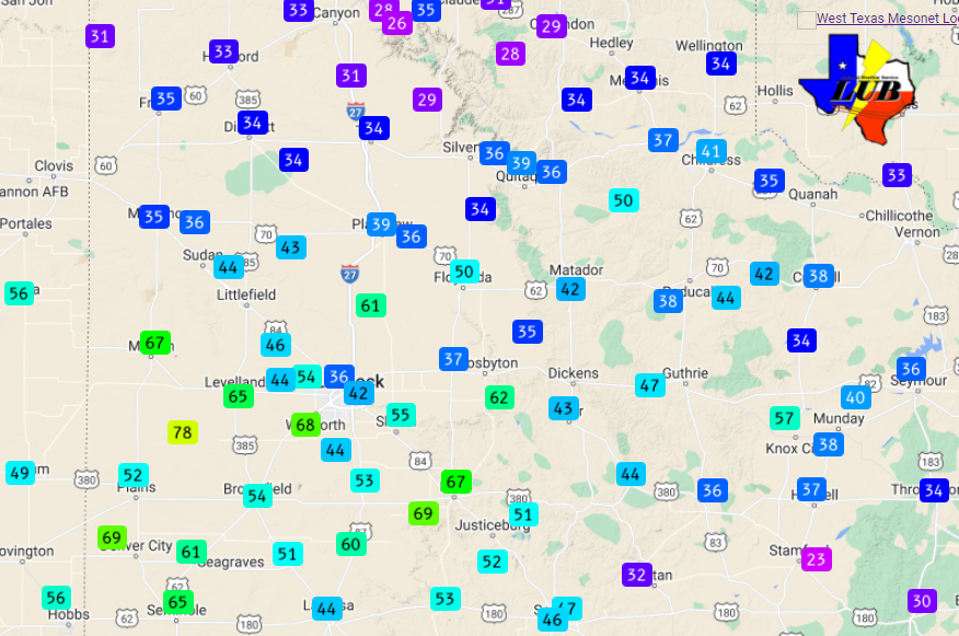
In contrast to the limited and short-lived landspouts, the bulging cluster of storms generated widespread wind gusts of 50 to 70+ mph across the central and southern South Plains Tuesday evening. A peak wind gust of 78 mph was measured by the West Texas Mesonet site located 8 miles west-southwest of Sundown. The intense winds blew the roof off a house and tore a basketball backboard out of its concrete pad in Meadow. The wind also knocked out power in a number of locations. |
|||
 |
|||
| Maximum wind gusts measured by the West Texas Mesonet on 24 May 2022. | |||
| Though excessive in spots, the two days of active weather brought rainfall to the entire region, and significant rain to much of the area. The heavier rain, from 1 to 3+ inches, fell on much of the South Plains, Rolling Plains and southern Texas Panhandle. However, locations near and south of a Plains to Brownfield to Post to Old Glory line generally recorded 1/2 to 1 inch of rain. Officially, the Lubbock Airport recorded 2.48 inches during this event, boosting the monthly total to 3.58 inches (1.59 inches above the monthly average through the 24th), and the year-to-date total to 3.96 inches (1.76 below the YTD average of 5.72 inches through May 24th). The rain made a welcome dent into the ongoing drought, but it will take additional widespread and significant rains to completely eradicate the drought. | |||
 |
|||
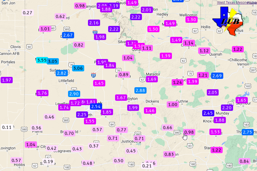
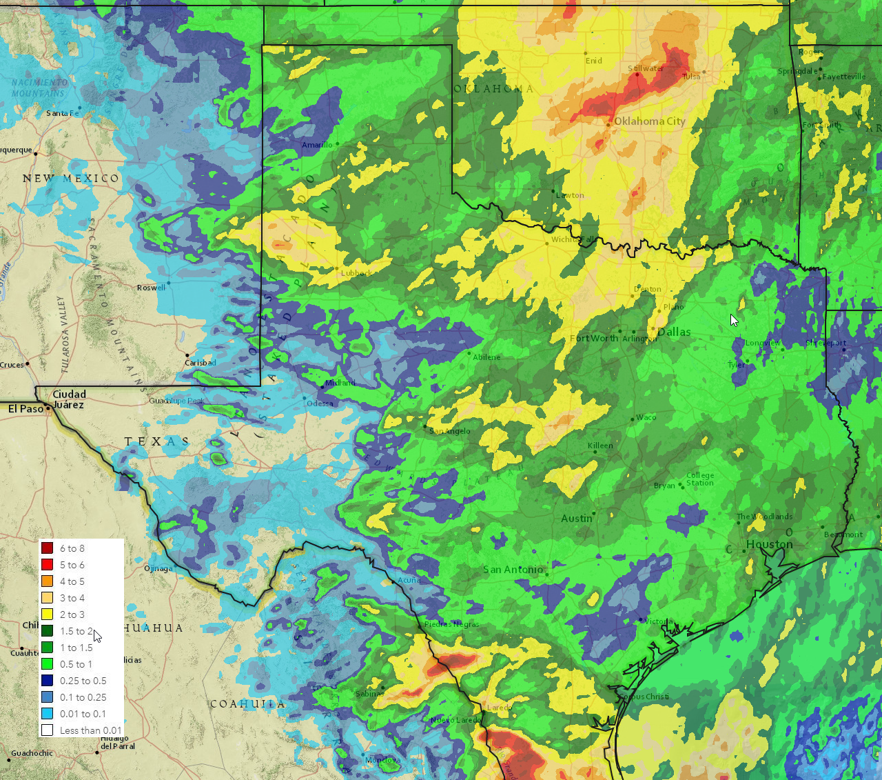
| 48-hour rain totals, as measured by the National Weather Service and West Texas Mesonet, ending at 9 am on 25 May 2022. The background is the radar-estimated and bias-corrected rain totals for the event. Exact rain totals from the West Texas Mesonet can be VIEWED HERE. A regional view of estimated rainfall amounts for this event can be FOUND HERE. | |||
|
You can view damage survey images and preliminary tornado tracks at: https://apps.dat.noaa.gov/StormDamage/DamageViewer/ Be patient, as the above page can be slow to load. Also, be sure to include 5/23/2022 within the data window (Begin and End Date) located on the upper right-hand side of the page in order to view the data for this event. The preliminary storm reports collected over this active late-May two-day stretch can be found below. |
|||
Public Information Statement...CORRECTED
National Weather Service Lubbock TX
240 PM CDT Thu May 26 2022

...NWS Damage Survey for 05/23/2022 Tornado Event...

.Overview...
Late afternoon on Monday, May 23, a cluster of thunderstorms moving northeast out of SE
New Mexico into the NW South Plains and interacted with an outflow boundary moving
northwest out of the Permian Basin. This caused a storm on the southern flank of the
cluster to begin to rotate and become supercellular and take a more easterly, then
southeasterly track. As the storm intensified it also became cyclic in behavior, and its
forward speed varied from about 5 mph to about 20 mph. The storm produced its first
brief tornado across northern Cochran County shortly before 7 pm Monday afternoon, with
the final observed tornado ending around 9 pm Monday evening just northwest of the town
of Levelland in north-central Hockley County. The National Weather Service at Lubbock
conducted a ground survey on Tuesday, May 24. Many roads across the affected area were
closed due to flooding, which limited access to where the tornadoes tracked. In addition,
radar data was provided by the Texas Tech Atmospheric Science Group and the NSSL TORUS
Field Campaign from one of their mobile Ka-band radars, and was useful for determining
the location and timing of several of the tornadoes.

.Northern Cochran County...

Rating:                 EF-Unknown
Estimated Peak Wind:    N/A
Path Length /statute/:  1 mile
Path Width /maximum/:   N/A
Fatalities:             0
Injuries:               0

Start Date:             05/23/2022
Start Time:             06:50 PM CDT
Start Location:         4 SE Maple / Cochran County / TX
Start Lat/Lon:          33.8136 / -102.8465

End Date:               05/23/2022
End Time:               06:55 PM CDT
End Location:           4 SE Maple / Cochran County / TX
End Lat/Lon:            33.8143 / -102.8292

Survey Summary:
Brief, needle-like tornado that became rain-wrapped observed by storms chasers.
No damage was observed or reported.


.Near Enochs...

Rating:                 EF-2
Estimated Peak Wind:    120 mph
Path Length /statute/:  3.1 miles
Path Width /maximum/:   1400.0 yards
Fatalities:             0
Injuries:               0

Start Date:             05/23/2022
Start Time:             07:03 PM CDT
Start Location:         4 SSW Enochs / Cochran County / TX
Start Lat/Lon:          33.8093 / -102.786

End Date:               05/23/2022
End Time:               07:18 PM CDT
End Location:           3 SSW Enochs / Bailey County / TX
End Lat/Lon:            33.8342 / -102.7815

Survey Summary:
Instantaneous width and center fix estimated from TTU-Ka1 radar data. Due to the lack of
damage indicators, the width of the tornado may have been wider than the surveyed extent.
Extensive photo and video evidence of a wide, dusty, wedge tornado with numerous sub-vortices
present at times.


.Bailey-Cochran County Line...

Rating:                 EF-Unknown
Estimated Peak Wind:    N/A
Path Length /statute/:  1.1 miles
Path Width /maximum/:   N/A
Fatalities:             0
Injuries:               0

Start Date:             05/23/2022
Start Time:             07:13 PM CDT
Start Location:         4 SSE Enochs / Cochran County / TX
Start Lat/Lon:          33.8213 / -102.7178

End Date:               05/23/2022
End Time:               07:22 PM CDT
End Location:           3 SE Enochs / Bailey County / TX
End Lat/Lon:            33.835 / -102.7157

Survey Summary:
While the larger tornado south of Enochs was occluding, a new circulation developed to the east,
and a brief, small tornado was reported by numerous chasers, including NWS spotters. No damage
observed or reported. TTU-Ka1 also sampled this tornado.


.Northeast Cochran County...

Rating:                 EF-Unknown
Estimated Peak Wind:    N/A
Path Length /statute/:  1.6 miles
Path Width /maximum/:   N/A
Fatalities:             0
Injuries:               0

Start Date:             05/23/2022
Start Time:             07:40 PM CDT
Start Location:         6 W Pep / Cochran County / TX
Start Lat/Lon:          33.7937 / -102.6694

End Date:               05/25/2022
End Time:               07:45 PM CDT
End Location:           5 WSW Pep / Cochran County / TX
End Lat/Lon:            33.788 / -102.6433

Survey Summary:
Short-lived, small tornado. Track estimated by TTU-Ka radar data.


.Northwest Hockley County...

Rating:                 EF-0
Estimated Peak Wind:    85 mph
Path Length /statute/:  1.93 miles
Path Width /maximum/:   N/A
Fatalities:             0
Injuries:               0

Start Date:             05/23/2022
Start Time:             08:06 PM CDT
Start Location:         3 SW Pep / Hockley County / TX
Start Lat/Lon:          33.7802 / -102.5942

End Date:               05/23/2022
End Time:               08:11 PM CDT
End Location:           2 S Pep / Hockley County / TX
End Lat/Lon:            33.7821 / -102.5608

Survey Summary:
Storm chaser footage of a brief, small tornado in an open field. Wooden power poles
blown down at the intersection of FM 597 and FM 303, 2 miles south of Pep. NWS survey
crew was unable to reach the damage area due to flooded roads.

.Pettit_1...

Rating:                 EF-Unknown
Estimated Peak Wind:    N/A
Path Length /statute/:  1.0 miles
Path Width /maximum/:   N/A
Fatalities:             0
Injuries:               0

Start Date:             05/23/2022
Start Time:             08:28 PM CDT
Start Location:         5 NNE Whiteface / Hockley County / TX
Start Lat/Lon:          33.6627 / -102.5785

End Date:               05/23/2022
End Time:               08:32 PM CDT
End Location:           4 NE Whiteface / Hockley County / TX
End Lat/Lon:            33.6542 / -102.5644

Survey Summary:
Short-lived, small tornado. Track estimated by TTU-Ka radar data.


.Pettit_2...

Rating:                 EF-Unknown
Estimated Peak Wind:    N/A
Path Length /statute/:  0.5 miles
Path Width /maximum/:   N/A
Fatalities:             0
Injuries:               0

Start Date:             05/23/2022
Start Time:             08:37 PM CDT
Start Location:         5 NE Whiteface / Hockley County / TX
Start Lat/Lon:          33.664 / -102.5559

End Date:               05/23/2022
End Time:               08:39 PM CDT
End Location:           5 NE Whiteface / Hockley County / TX
End Lat/Lon:            33.6636 / -102.5482

Survey Summary:
Short-lived, small tornado. Track estimated by TTU-Ka radar data.


.Pettit_Coble...

Rating:                 EF-2
Estimated Peak Wind:    120 mph
Path Length /statute/:  8.4 miles
Path Width /maximum/:   1420 yards
Fatalities:             0
Injuries:               0

Start Date:             05/23/2022
Start Time:             08:40 PM CDT
Start Location:         4 ENE Whiteface / Hockley County / TX
Start Lat/Lon:          33.6266 / -102.5438

End Date:               05/23/2022
End Time:               08:58 PM CDT
End Location:           7 WSW Whitharral / Hockley County / TX
End Lat/Lon:            33.6829 / -102.4312

Survey Summary:
The survey found several locations along FM 303 with wooden power poles snapped at the base
and two oil pump jacks overturned. The damage survey could not be continued farther east as
roads were closed due to flooding. The remaining tornado track and end point estimated by
KLBB WSR-88D Data.

&&

EF Scale: The Enhanced Fujita Scale classifies tornadoes into the
following categories:

EF0...Weak......65 to 85 mph
EF1...Weak......86 to 110 mph
EF2...Strong....111 to 135 mph
EF3...Strong....136 to 165 mph
EF4...Violent...166 to 200 mph
EF5...Violent...>200 mph

NOTE:
The information in this statement is preliminary and subject to
change pending final review of the events and publication in NWS
Storm Data.

NWS Lubbock thanks the Texas Tech-Atmospheric Science group and NSSL
for their contributions of radar data.

