|
Another round of wind, dust and wildfires |
|
 |
|
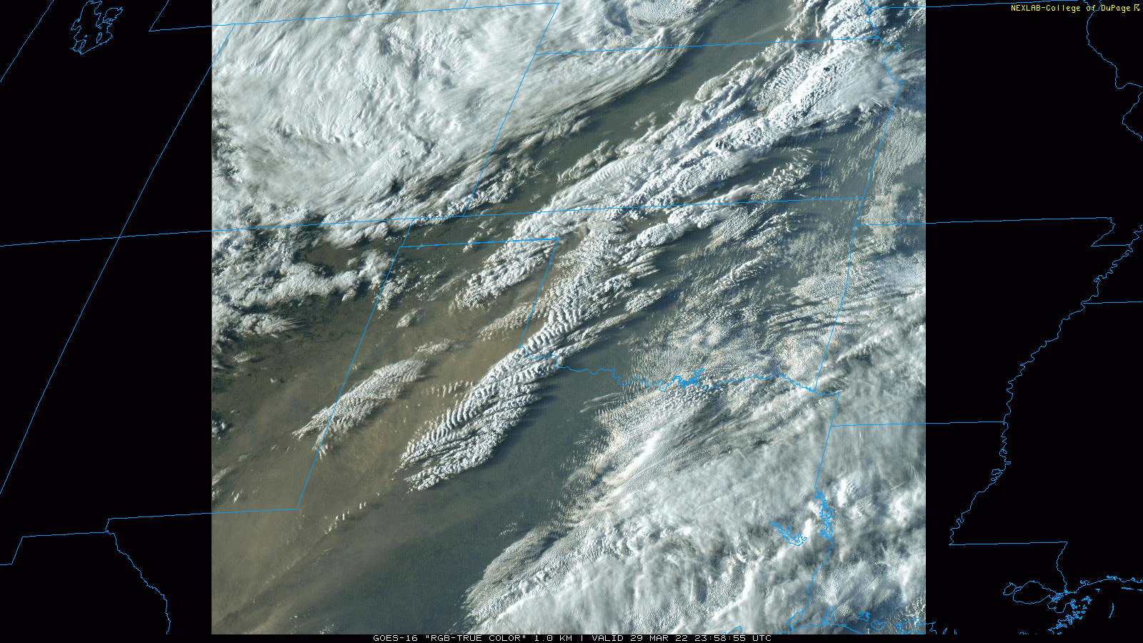
| "True Color" satellite loop valid from 6:58 pm to 7:07 pm on Tuesday (29 March 2022). Note the extensive dust plume moving from southwest-to-northeast from Far West Texas over the South Plains and Texas Panhandle. | |
|
The approach and passage of a large and intense storm system brought another round of wind, dust and fire weather to West Texas in late March 2022. The winds really cranked up Tuesday afternoon (March 29th), as the system ejected from the central and southern Rockies into the High Plains. Southwesterly to westerly winds gusting to 55+ mph spread eastward over much of the Caprock during the afternoon and evening hours. |
|
 |
|
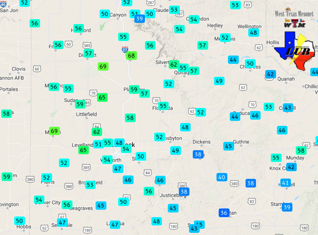
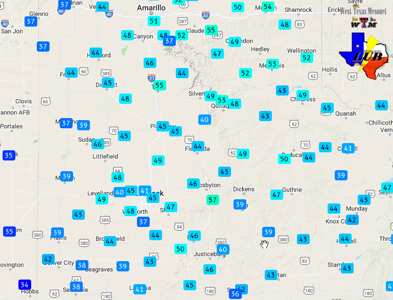
| Maximum wind gusts measured by the West Texas Mesonet on Tuesday, 29 March 2022. The peak sustained wind speeds for the day can be VIEWED HERE. | |
|
The strongest winds, in excess of 65 mph, affected the western South Plains into the south-central Texas Panhandle, generally peaking between 2 pm and 7 pm. Copious amounts of blowing dust were lifted by the winds and spread northeastward across the region. |
|
 |
|
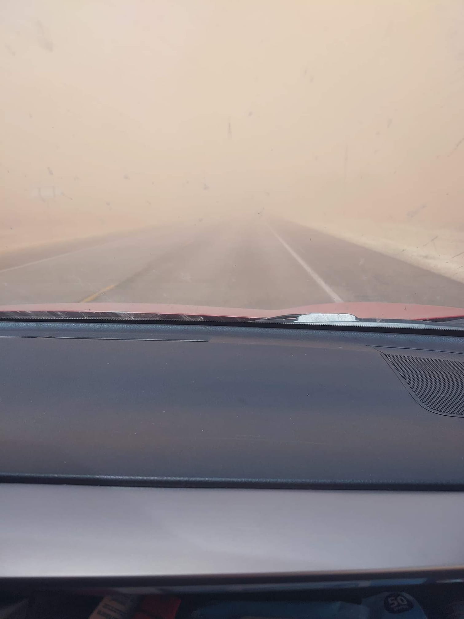
| Dusty scene north of Littlefield Tuesday evening. The picture is courtesy of Misty Bair. | |
|
The limited visibility from the blowing dust made travel hazardous in spots. Officially, the Lubbock Airport reported a visibility of 4 miles or less from 5 pm to 9 pm, thanks to the expansive blowing dust, while Plainview experienced similar conditions from 1 pm to 8 pm. However, the wind and dust weren't the only hazards. The warm and dry winds, in combination with the ongoing drought, supported the development and spread of several wildfires from Kansas into parts Oklahoma, Texas and eastern New Mexico. |
|
 |
|
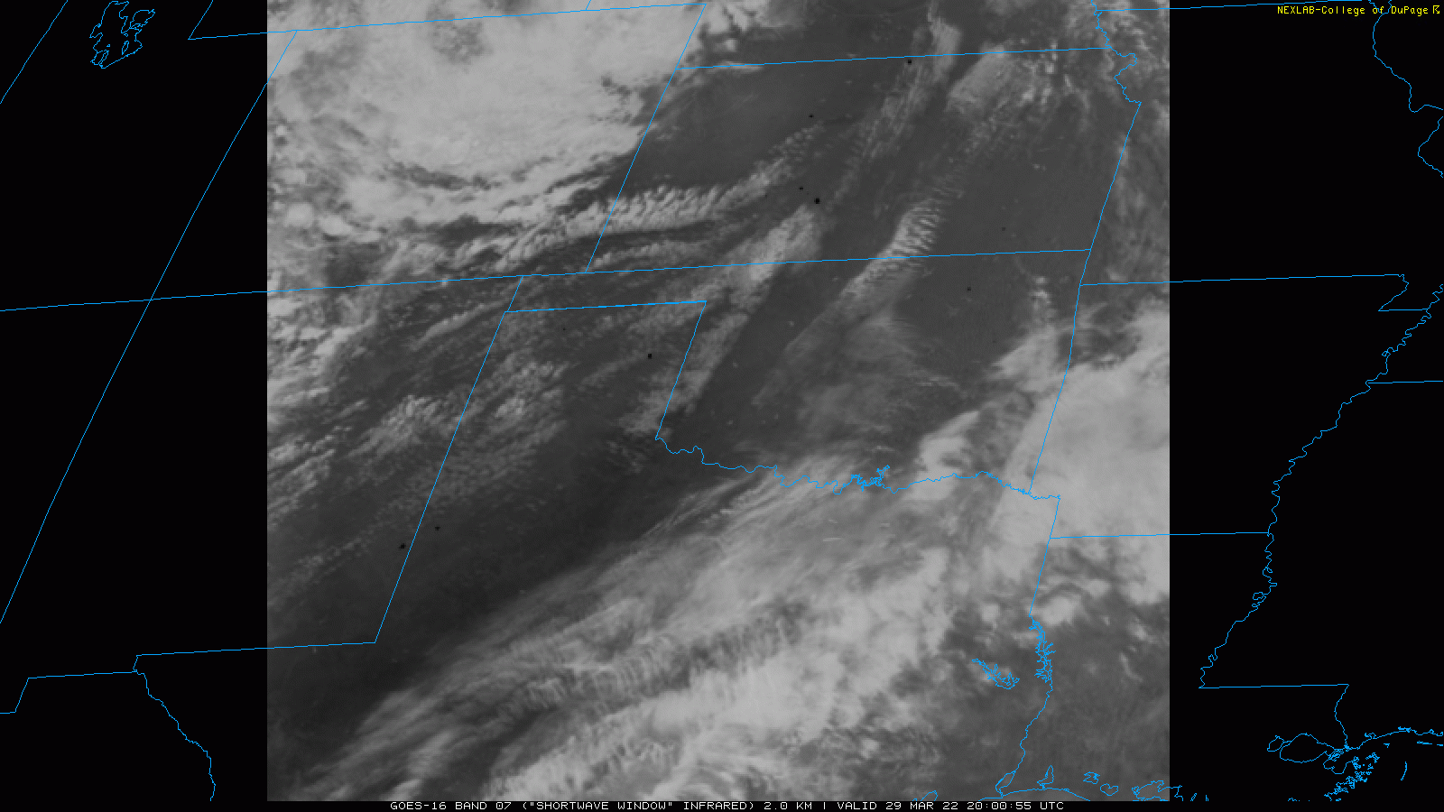
| "Shortwave Window" Infrared satellite loop valid from 3:00 pm to 3:08 pm on Tuesday (29 March 2022). Note the "hot spots" (dark spots) indicate ongoing wildfires. | |
|
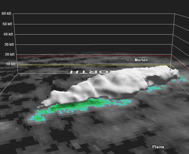
A few of the wildfires occurred in the NWS Lubbock area, including one that ignited near FM 1585 in southern Cochran County, as well as an intense wildfire that developed in Lea County, NM, but was pushed rapidly eastward across the TX/NM line before being extinguished. A radar cross-section of the Lea County fire/smoke can be viewed below. |
|
 |
|
| Lubbock radar cross-section taken of the smoke plume from a wildfire affecting parts of Lea, Yoakum and Cochran Counties Tuesday afternoon (29 March 2022). | |
|
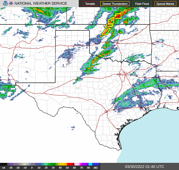
Further east, where moisture was present, thunderstorms developed along a dryline across the far eastern Rolling Plains Tuesday evening. This activity clipped southeastern Stonewall County before shifting eastward and bringing widespread rain and isolated severe weather to North and Central Texas through the late evening and overnight hours. |
|
 |
|
| Regional radar animation valid from 8:40 pm to 9:06 pm on 29 March 2022. | |
|
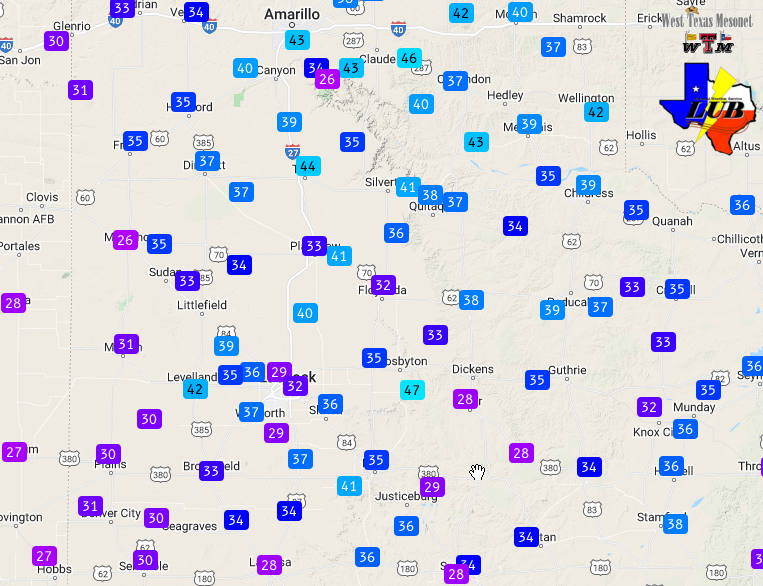
A cold front moved followed late Tuesday night, providing a northerly wind shift and another bout of strong winds Wednesday morning. Wind gusts of 40-50+ mph were common behind the front Wednesday morning, before gradually easing through the afternoon hours. These gusty winds did kick up a little blowing dust too, but nothing like the previous day. In addition, a few rain showers spread southward from the southern Texas Panhandle into the South Plains Wednesday morning. Unfortunately, the rainfall was spotty and light, from a trace to several hundredths of an inch. |
|
 |
|
| Maximum wind gusts measured by the West Texas Mesonet on Wednesday, 30 March 2022. The peak sustained wind speeds for the day can be VIEWED HERE. | |
|
The preliminary storm reports collected over these windy days can be found below. |
|
PRELIMINARY LOCAL STORM REPORT...SUMMARY
NATIONAL WEATHER SERVICE LUBBOCK TX
1034 PM CDT TUE MAR 29 2022

..TIME...   ...EVENT...      ...CITY LOCATION...     ...LAT.LON...
..DATE...   ....MAG....      ..COUNTY LOCATION..ST.. ...SOURCE....
            ..REMARKS..

0102 AM     NON-TSTM WND GST 3 N HART                34.42N 102.11W
03/29/2022  M69 MPH          CASTRO             TX   MESONET

1225 PM     NON-TSTM WND GST 4 S LEVELLAND           33.53N 102.36W
03/29/2022  M65 MPH          HOCKLEY            TX   MESONET

            WEST TEXAS MESONET

0207 PM     NON-TSTM WND GST 1 ENE MORTON            33.73N 102.74W
03/29/2022  M60 MPH          COCHRAN            TX   MESONET

            WEST TEXAS MESONET

0211 PM     NON-TSTM WND GST 2 ENE TULIA             34.54N 101.74W
03/29/2022  M60 MPH          SWISHER            TX   MESONET

            WEST TEXAS MESONET

0246 PM     NON-TSTM WND GST 2 ENE TULIA             34.54N 101.74W
03/29/2022  M68 MPH          SWISHER            TX   MESONET

            WEST TEXAS MESONET

0413 PM     NON-TSTM WND GST 2 ENE TULIA             34.54N 101.74W
03/29/2022  M65 MPH          SWISHER            TX   MESONET

            SUSTAINED WIND 46 MPH.

0432 PM     NON-TSTM WND GST 1 S PLAINVIEW           34.18N 101.71W
03/29/2022  M59 MPH          HALE               TX   MESONET

            SUSTAINED WIND 40 MPH.

0456 PM     NON-TSTM WND GST 1 NE AMHERST            34.02N 102.40W
03/29/2022  M58 MPH          LAMB               TX   MESONET

0458 PM     NON-TSTM WND GST 5 ENE ABERNATHY         33.88N 101.76W
03/29/2022  M58 MPH          HALE               TX   MESONET

0520 PM     NON-TSTM WND GST 1 ENE MORTON            33.73N 102.74W
03/29/2022  M68 MPH          COCHRAN            TX   MESONET

            SUSTAINED WIND 47 MPH.

0521 PM     NON-TSTM WND GST 1 ENE MORTON            33.73N 102.74W
03/29/2022  M69 MPH          COCHRAN            TX   MESONET

            SUSTAINED WIND SPEED 47 MPH.

0646 PM     NON-TSTM WND GST 4 S LEVELLAND           33.53N 102.36W
03/29/2022  M59 MPH          HOCKLEY            TX   MESONET

0653 PM     NON-TSTM WND GST 6 SSW ANTON             33.73N 102.19W
03/29/2022  M64 MPH          HOCKLEY            TX   MESONET

            SUSTAINED WIND 49 MPH.

0701 PM     NON-TSTM WND GST 6 NNE LUBBOCK           33.67N 101.82W
03/29/2022  M60 MPH          LUBBOCK            TX   ASOS

            SUSTAINED WIND 40 MPH.

