|
Bitter cold and wintry weather pay a visit to West Texas |
|
 |
|
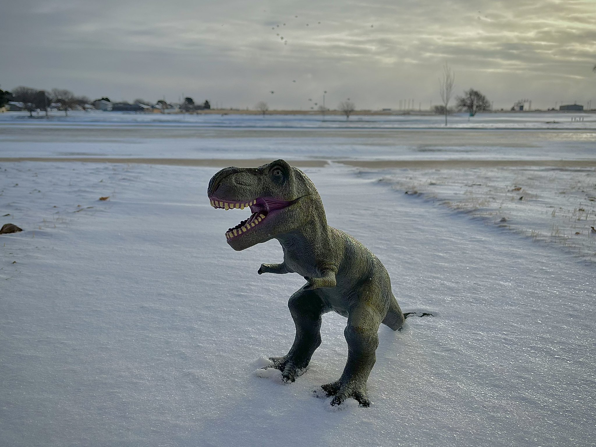
| Wintry scene in Levelland, Texas, Thursday (3 February 2022). The image is courtesy of Chris Zorel. | |
|
Early February 2022 brought a brutal shot of Arctic air, complete with wintry precipitation. The bitter cold was reminiscent of the air that invaded Texas just one year ago, in mid-February 2021, though it didn't stick around as long as that crippling event. |
|
 |
|
| Water vapor imagery loop valid from 8:11 to 9:06 pm on 2 February 2022. A broad stream of mid-upper level moisture is seen blanketing much of Texas. | |
| Even so, the plunging temperatures did provide a dose of reality after highs in the 60s and 70s just days earlier. Changes were in the air as early as February 1st, when the initial cold front moved through northwestern Texas, dropping highs into the 50s for most locations, complete with breezy northerly winds. However, this was just a taste of what was to come as the leading edge of the Arctic air, with origins from Alaska and points north and west from there, built in on gusty northerly winds late Tuesday night into Wednesday (February 2nd). | |
 |
|
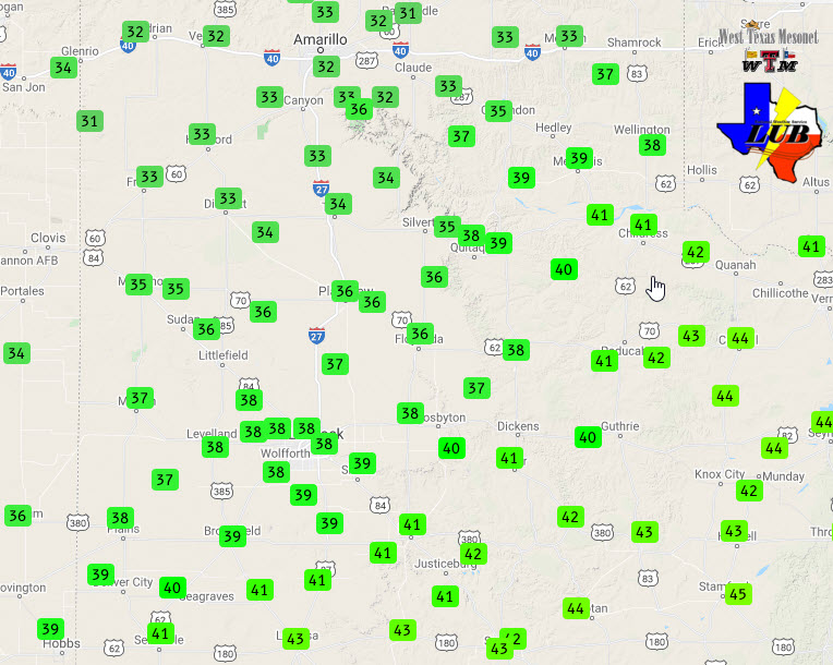
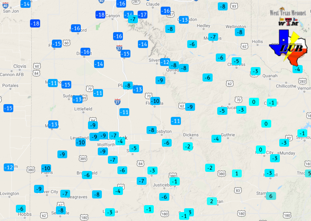
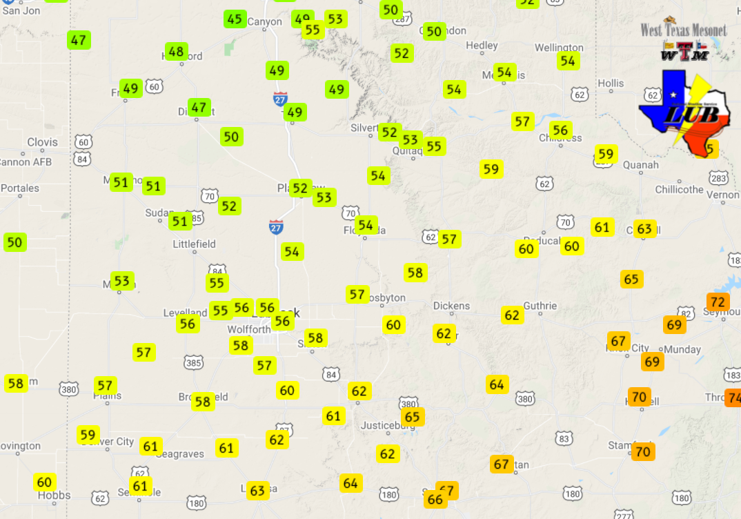
| High temperatures observed on Wednesday (2 February 2022) by the West Texas Mesonet. These highs occurred early in the day, as temperatures fell throughout the daytime hours. Highs from the 1st can be VIEWED HERE. | |
|
Highs on Wednesday only reached the 30s and lower 40s, and that was early in the day, as temperatures dropped through much of the daylight hours as stout northerly winds carried in the colder air. At the same time, a broad fetch of Pacific moisture streamed over much of Texas ahead of a broad mid-upper level trough gradually approaching via the Rockies. |
|
 |
|
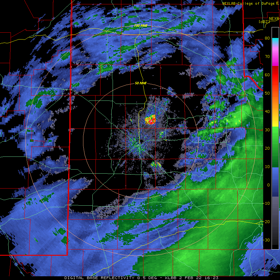
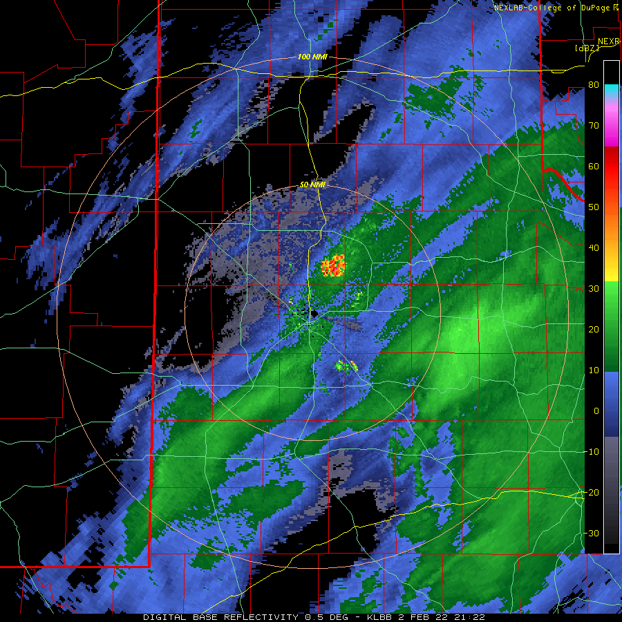
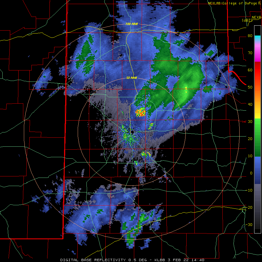
| Lubbock WSR-88D base reflectivity loop valid from 10:23 am to 3:13 pm on 2 February 2022. | |
|
Precipitation developed on Wednesday as the moisture was lifted up and over the invading cold air. Where temperatures were "warm" enough, rain changed to freezing rain, then sleet across parts of the Rolling Plains and points south and east from there during the day Wednesday. Further west, where the cold air was more entrenched, areas of snow developed and spread northeastward across parts of the South Plains and Texas Panhandle. |
|
 |
|
| Deep snow drift in Jayton, Texas, Thursday afternoon (3 February 2022). The image is courtesy of Jeremy Carter. | |
|
By Wednesday evening, it was cold enough that snow was the dominate mode across all of the South Plains and Rolling Plains. Areas of snow continued, off and on, Wednesday night and into Thursday morning (February 3rd). Temperatures continued to fall, bottoming out in the single digits and lower teens early Thursday, which when combined with northerly winds sustained near 20 mph, made it feel like 0 to -15 degrees or colder. |
|
 |
|
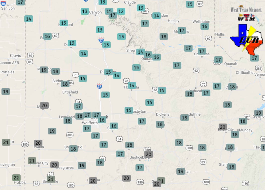
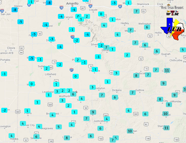
| Wind Chill values observed at 6:20 am on Thursday (3 February 2022) by the West Texas Mesonet. The low temperatures measured this morning can be VIEWED HERE. | |
|
The bitter chill didn't ease much Thursday afternoon as highs only reached the teens in most locations, and the gusty northerly winds persisted. In fact, Lubbock only reached 17 degrees, which tied a record minimum high (last set in 1989). Coincidentally, the record high for the date (February 3rd) was set last year (2021), when the mercury reached 81 degrees. In addition to the cold, a band of light to moderate snow developed across the southwest Texas Panhandle and northwest South Plains Thursday morning, then slowly spread southeastward through the afternoon hours, bringing additional light accumulations. |
|
 |
|
| Lubbock WSR-88D base reflectivity loop valid from 3:22 to 8:23 pm on 2 February 2022. An additional radar animation, valid from 12:07 am to 6:13 am on February 3rd, can be FOUND HERE. A final radar animation, valid from 8:40 am to 1:30 pm on February 3rd, can be VIEWED HERE. | |
|
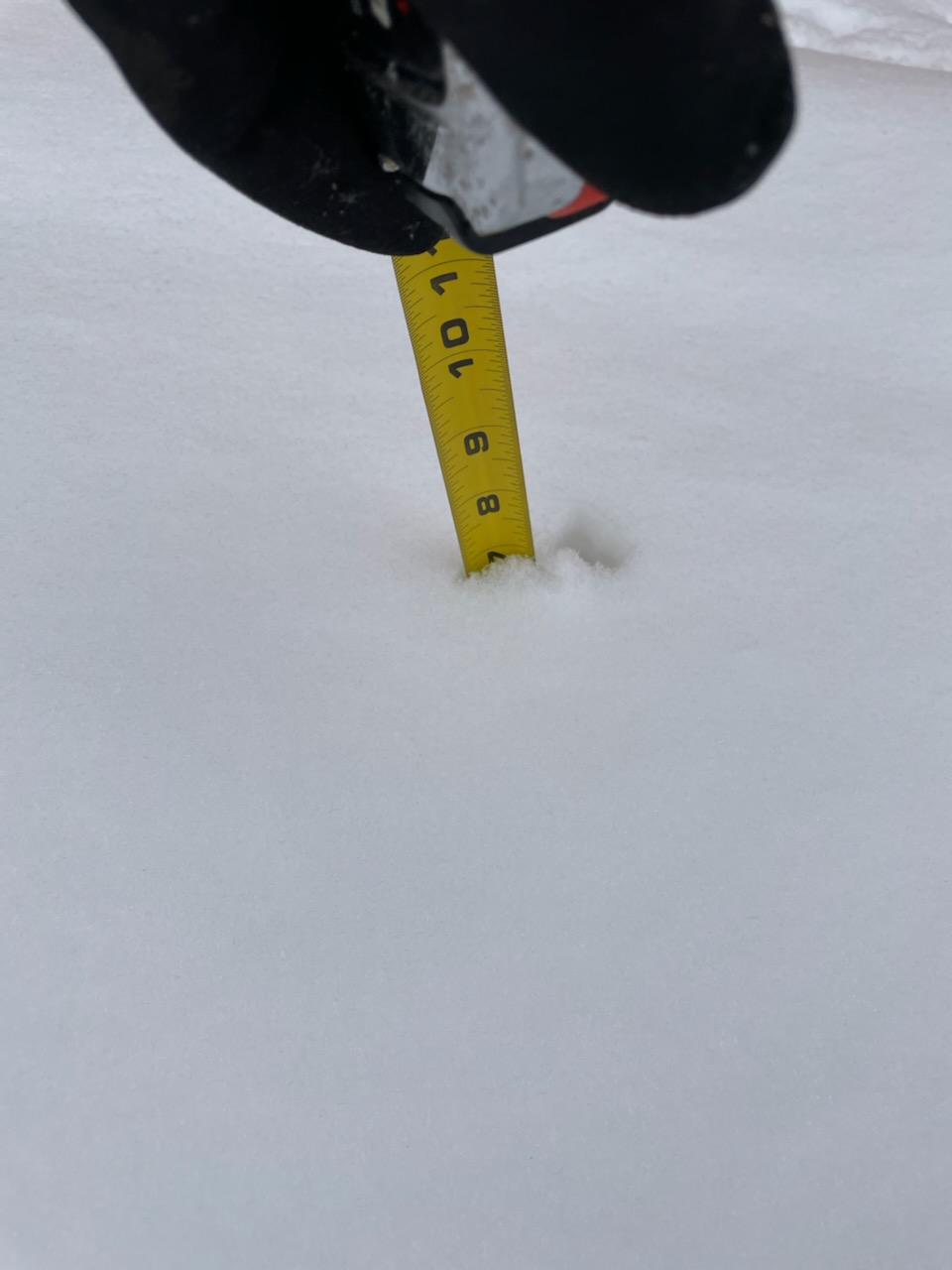
The snow finally tapered off Thursday night, but not before dropping widespread 1 to 3 inch totals. The light and fluffy snow, coupled with the very cold temperatures, resulted in slick and hazardous travel. The heaviest sleet and snow (including a glaze of ice early on) impacted the southern Rolling Plains, where 3 to 4+ inches were common. |
|
 |
|
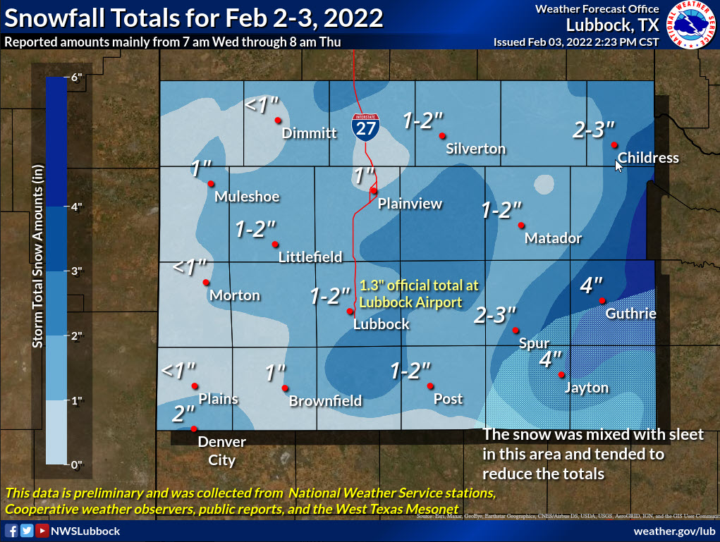
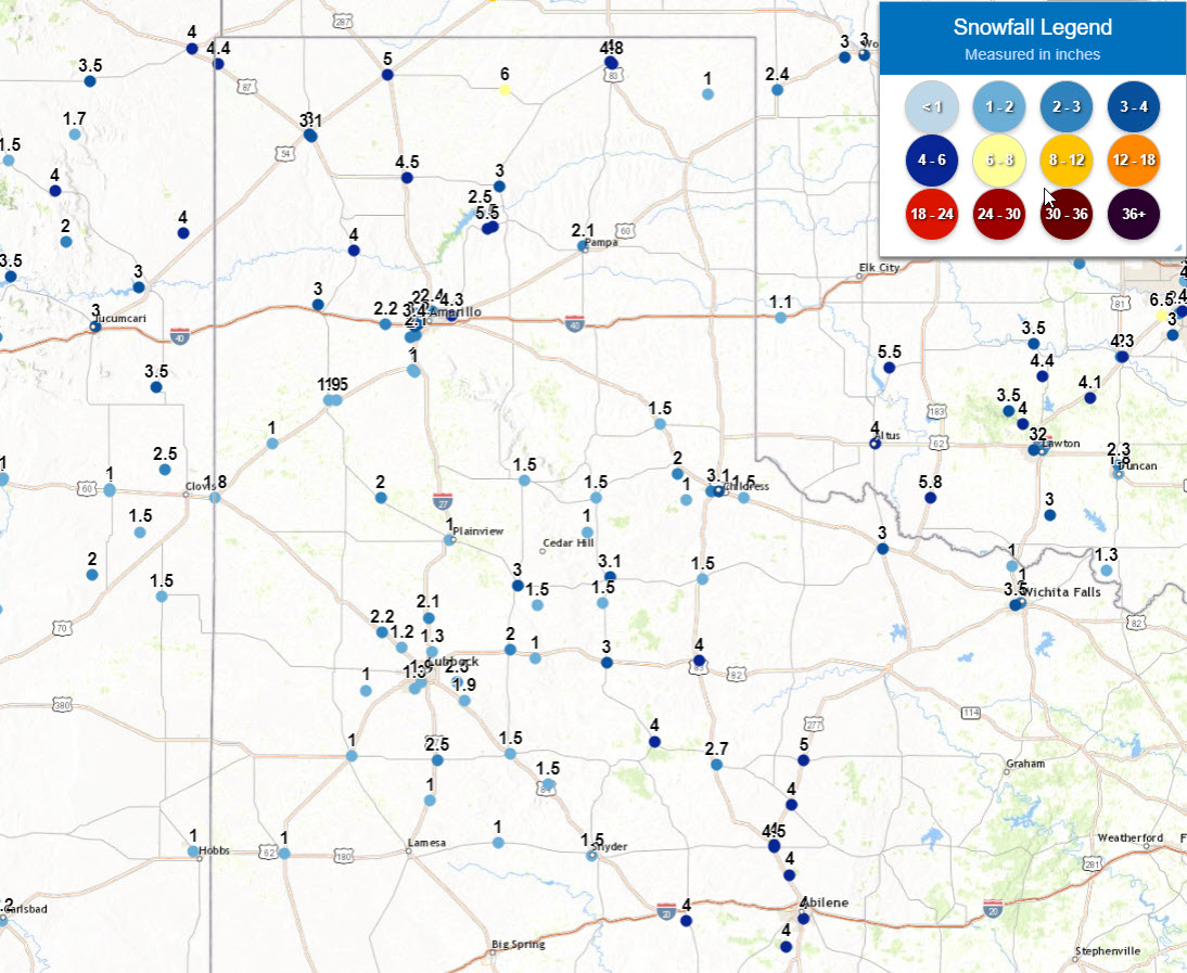
| Snow and sleet totals (inches), as reported to the Lubbock NWS, through Thursday morning (3 February 2022). A plot of the preliminary snow reports can be VIEWED HERE. | |
|
Officially, Lubbock recorded 1.6 inches of snow, but only 0.12 inches of liquid when melted down. Unfortunately, overall liquid equivalents were on the low side, though the entire region received at least a little moisture. Skies eventually cleared late Thursday night, leading to an extremely cold night, with lows reaching the single digits above and below zero. Thankfully, plenty of sunshine and weakening northerly breezes allowed temperatures to recover above freezing Friday afternoon. |
|
 |
|
|
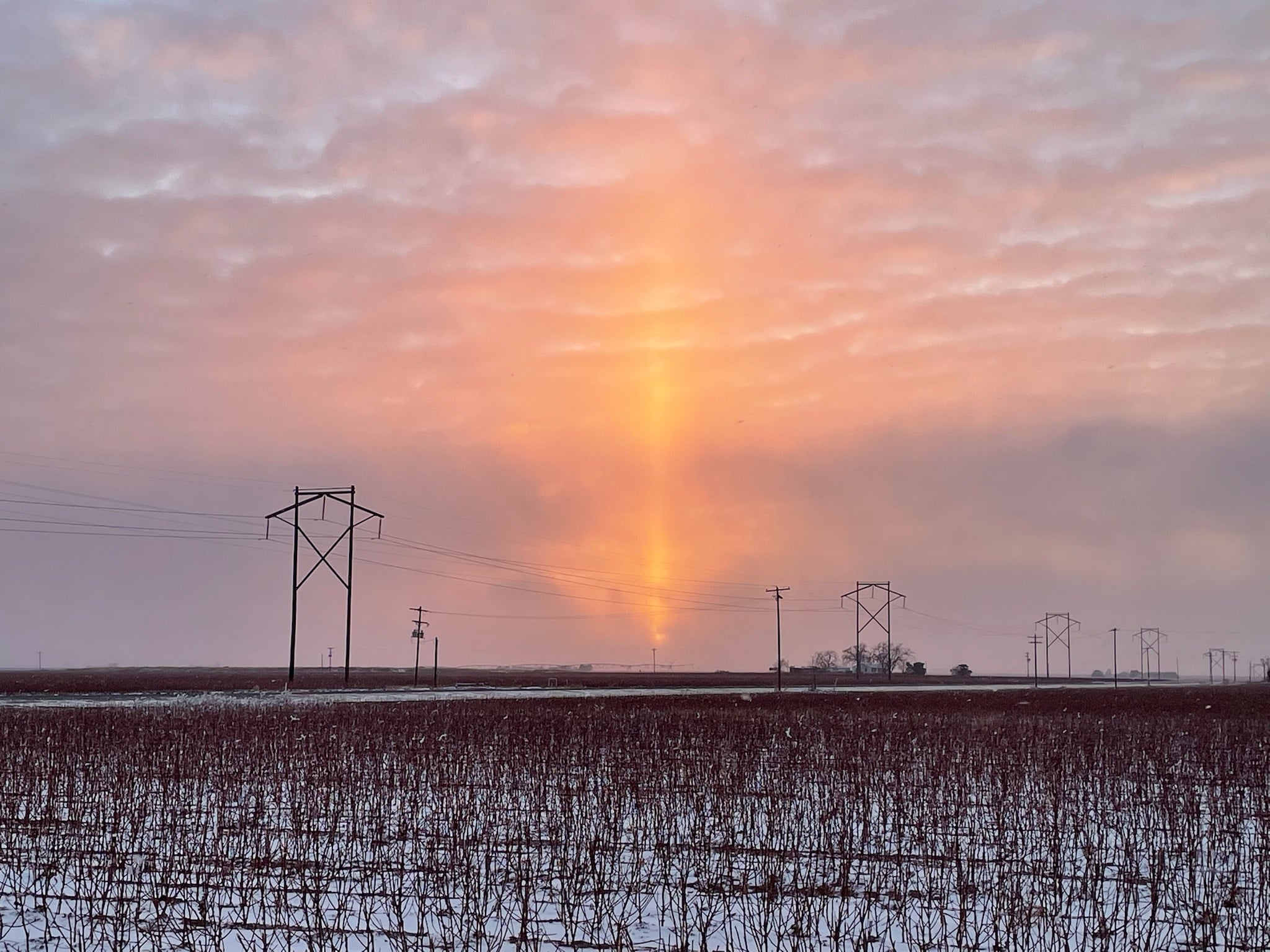
It's a Sun pillar! These are more commonly seen up in the Arctic at sunrise or sunset, but it was just cold enough and just clear enough to spy one in West Texas on Thursday evening. The picture is courtesy of the West Texas Mesonet. |
|
| The preliminary storm reports collected over this cold and wintry stretch can be found below. |
PRELIMINARY LOCAL STORM REPORT...SUMMARY
NATIONAL WEATHER SERVICE LUBBOCK TX
1052 AM CST THU FEB 03 2022

..TIME...   ...EVENT...      ...CITY LOCATION...     ...LAT.LON...
..DATE...   ....MAG....      ..COUNTY LOCATION..ST.. ...SOURCE....
            ..REMARKS..

1245 PM     HEAVY SLEET      ASPERMONT               33.14N 100.22W
02/02/2022  E0.5 INCH        STONEWALL          TX   LAW ENFORCEMENT

            STONEWALL COUNTY SHERIFF REPORTS 1/2" OF SLEET ON
            GRASSY SURFACES WITH A SLUSH ON AREA ROADWAYS.

0746 PM     HEAVY SNOW       POST                    33.19N 101.38W
02/02/2022  E1.5 INCH        GARZA              TX   LAW ENFORCEMENT

0753 PM     HEAVY SNOW       DICKENS                 33.62N 100.84W
02/02/2022  E1.0 INCH        DICKENS            TX   LAW ENFORCEMENT

0600 AM     HEAVY SNOW       4 SSW LUBBOCK           33.53N 101.88W
02/03/2022  M1.5 INCH        LUBBOCK            TX   NWS OFFICE

0600 AM     HEAVY SNOW       ROUNDUP                 33.76N 102.10W
02/03/2022  M2.2 INCH        HOCKLEY            TX   COCORAHS

0726 AM     HEAVY SNOW       ABERNATHY               33.83N 101.84W
02/03/2022  M2.1 INCH        HALE               TX   CO-OP OBSERVER

0726 AM     HEAVY SNOW       HART                    34.39N 102.11W
02/03/2022  E2.0 INCH        CASTRO             TX   CO-OP OBSERVER

0733 AM     HEAVY SNOW       FRIONA                  34.64N 102.72W
02/03/2022  M1.0 INCH        PARMER             TX   CO-OP OBSERVER

0735 AM     HEAVY SNOW       FARWELL                 34.39N 103.04W
02/03/2022  E1.8 INCH        PARMER             TX   LAW ENFORCEMENT

            ESTIMATED 1.5 TO 2 INCHES OF SNOW

0737 AM     HEAVY SNOW       PLAINVIEW               34.19N 101.72W
02/03/2022  E1.0 INCH        HALE               TX   CO-OP OBSERVER

0742 AM     HEAVY SNOW       POST                    33.19N 101.38W
02/03/2022  E1.5 INCH        GARZA              TX   CO-OP OBSERVER

0746 AM     HEAVY SNOW       TAHOKA                  33.16N 101.79W
02/03/2022  E2.5 INCH        LYNN               TX   CO-OP OBSERVER

0752 AM     HEAVY SNOW       BROWNFIELD              33.18N 102.27W
02/03/2022  E1.0 INCH        TERRY              TX   CO-OP OBSERVER

0757 AM     HEAVY SNOW       ASPERMONT               33.14N 100.22W
02/03/2022  M2.7 INCH        STONEWALL          TX   CO-OP OBSERVER

            A COMBINATION OF SLEET AND SNOW AFTER A PERIOD OF RAIN
            AND FREEZING RAIN.

0800 AM     HEAVY SNOW       6 SSW LUBBOCK           33.50N 101.92W
02/03/2022  M1.3 INCH        LUBBOCK            TX   COCORAHS

0802 AM     HEAVY SNOW       6 NNE LUBBOCK           33.67N 101.82W
02/03/2022  M1.3 INCH        LUBBOCK            TX   WX OBSERVER FAA

            OFFICIAL SNOWFALL MEASUREMENT THROUGH 8 AM

0811 AM     HEAVY SNOW       9 SE FLOYDADA           33.89N 101.23W
02/03/2022  M1.5 INCH        FLOYD              TX   CO-OP OBSERVER

0813 AM     HEAVY SNOW       2 ENE JUSTICEBURG       33.05N 101.17W
02/03/2022  M1.5 INCH        GARZA              TX   TRAINED SPOTTER

0820 AM     HEAVY SNOW       2 E FLOMOT              34.23N 100.95W
02/03/2022  M1.0 INCH        MOTLEY             TX   CO-OP OBSERVER

0832 AM     HEAVY SNOW       CROSBYTON               33.64N 101.24W
02/03/2022  M1.0 INCH        CROSBY             TX   CO-OP OBSERVER

0843 AM     HEAVY SNOW       MATADOR                 34.02N 100.82W
02/03/2022  M3.1 INCH        MOTLEY             TX   CO-OP OBSERVER

            THE REPORT INCLUDES ABOUT 1 INCH OF SLEET. SNOW DRIFTS
            TO 1 FOOT.

0846 AM     HEAVY SNOW       MEMPHIS                 34.73N 100.54W
02/03/2022  E1.5 INCH        HALL               TX   CO-OP OBSERVER

0848 AM     HEAVY SNOW       DICKENS                 33.62N 100.84W
02/03/2022  M3.0 INCH        DICKENS            TX   LAW ENFORCEMENT

0852 AM     HEAVY SNOW       RALLS                   33.68N 101.38W
02/03/2022  E2.0 INCH        CROSBY             TX   PUBLIC

0854 AM     HEAVY SNOW       ROARING SPRINGS         33.90N 100.86W
02/03/2022  E1.5 INCH        MOTLEY             TX   CO-OP OBSERVER

            ESTIMATED 1-2 INCHES OF SNOW

0900 AM     HEAVY SNOW       SHALLOWATER             33.69N 101.99W
02/03/2022  M1.2 INCH        LUBBOCK            TX   CO-OP OBSERVER

0900 AM     HEAVY SNOW       6 NNW ROPESVILLE        33.49N 102.19W
02/03/2022  M1.0 INCH        HOCKLEY            TX   CO-OP OBSERVER

0900 AM     HEAVY SNOW       RANSOM CANYON           33.53N 101.68W
02/03/2022  M2.5 INCH        LUBBOCK            TX   COCORAHS

0914 AM     HEAVY SNOW       CHILDRESS               34.42N 100.25W
02/03/2022  M2.0 INCH        CHILDRESS          TX   CO-OP OBSERVER

0915 AM     HEAVY SNOW       FLOYDADA                33.98N 101.34W
02/03/2022  E3.0 INCH        FLOYD              TX   CO-OP OBSERVER

0917 AM     HEAVY SNOW       SILVERTON               34.47N 101.30W
02/03/2022  E1.5 INCH        BRISCOE            TX   CO-OP OBSERVER

0919 AM     HEAVY SNOW       2 E CHILDRESS           34.42N 100.21W
02/03/2022  M3.1 INCH        CHILDRESS          TX   CO-OP OBSERVER

0924 AM     HEAVY SNOW       KIRKLAND                34.39N 100.07W
02/03/2022  M1.5 INCH        CHILDRESS          TX   CO-OP OBSERVER

0925 AM     HEAVY SNOW       TELL                    34.38N 100.39W
02/03/2022  M1.0 INCH        CHILDRESS          TX   CO-OP OBSERVER

0926 AM     HEAVY SNOW       GUTHRIE                 33.63N 100.32W
02/03/2022  M4.0 INCH        KING               TX   CO-OP OBSERVER

0930 AM     HEAVY SNOW       SLATON                  33.44N 101.64W
02/03/2022  M1.9 INCH        LUBBOCK            TX   CO-OP OBSERVER

0934 AM     HEAVY SNOW       JAYTON                  33.25N 100.57W
02/03/2022  E2.3 INCH        KENT               TX   LAW ENFORCEMENT

            ESTIMATED 2 TO 2.5 INCHES OF SNOW. THE EVENT STARTED
            WITH A PERIOD OF SLEET.

0944 AM     HEAVY SNOW       TURKEY                  34.39N 100.90W
02/03/2022  E1.5 INCH        HALL               TX   CO-OP OBSERVER

            ESTIMATED 1 TO 2 INCHES OF SNOW

0946 AM     HEAVY SNOW       PADUCAH                 34.01N 100.30W
02/03/2022  E1.5 INCH        COTTLE             TX   PUBLIC

1000 AM     HEAVY SNOW       O`DONNELL               32.97N 101.83W
02/03/2022  E1.0 INCH        LYNN               TX   PUBLIC

1050 AM     HEAVY SNOW       4 SSW LUBBOCK           33.53N 101.88W
02/03/2022  M1.9 INCH        LUBBOCK            TX   NWS OFFICE

            COMBINATION OF THREE 6-HOUR TOTALS PLUS THE LATEST 5
            HOURS OF SNOWFALL.

1100 AM     HEAVY SNOW       3 S ESTELLINE           34.50N 100.44W
02/03/2022  M2.0 INCH        HALL               TX   TRAINED SPOTTER

1125 AM     HEAVY SLEET      OLD GLORY               33.13N 100.06W
02/03/2022  E2.8 INCH        STONEWALL          TX   PUBLIC

            FELL PRIMARILY AS SLEET, WITH A LITTLE SNOW AT THE END.

0125 PM     HEAVY SNOW       JAYTON                  33.25N 100.57W
02/03/2022  M4.0 INCH        KENT               TX   CO-OP OBSERVER

            COMBINATION OF SLEET AND SNOW

