|
Widespread precipitation falls on the South Plains region |
|
 |
|
| A solid coating of snow in Friona Saturday morning (28 November 2020). The image is courtesy of Storm Search 7. | |
|
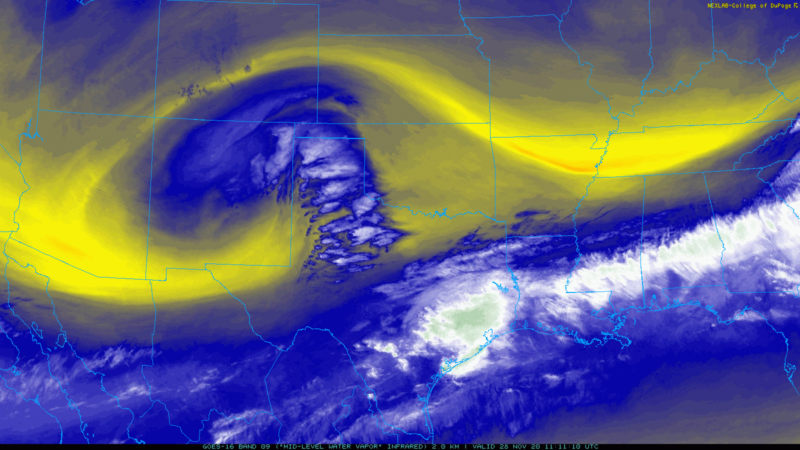
A potent upper level low, the second in less than a week, affected West Texas on Saturday, November 28th. As the system approached through New Mexico it drew relatively moist air up and over a cooler dome that had invaded the region Thanksgiving evening (26 November). This cause clouds to develop over the region late Friday, and precipitation to blossom early Saturday. |
|
 |
|
| Water vapor satellite loop captured early Saturday morning (28 November 2020). | |
| The rain showers, accompanied by a few rumbles of thunder, initially developed over the western South Plains during the predawn hours of the 28th. This activity grew in coverage as it spread north and eastward ahead of the approaching storm system. Most of the showers fell as a cold rain, with temperatures mostly in the middle and upper 30s. However, across the southwest Texas Panhandle and northern South Plains temperatures dropped into the lower 30s, which allowed the rain to mix with and change to snow. | |
 |
|
| Lubbock WSR-88D animation valid from 1:26 am to 5:55 am on November 24th. | |
| The heaviest snow fell over the western Texas Panhandle, including near Adrian and Vega, where 5 and 3 inches were measured, respectively. Further south, around an inch of snow fell in Hereford and Friona, with a half inch recorded in Dimmitt. Thankfully, the roads were just warm enough to remain mostly wet and limit impacts. | |
 |
|
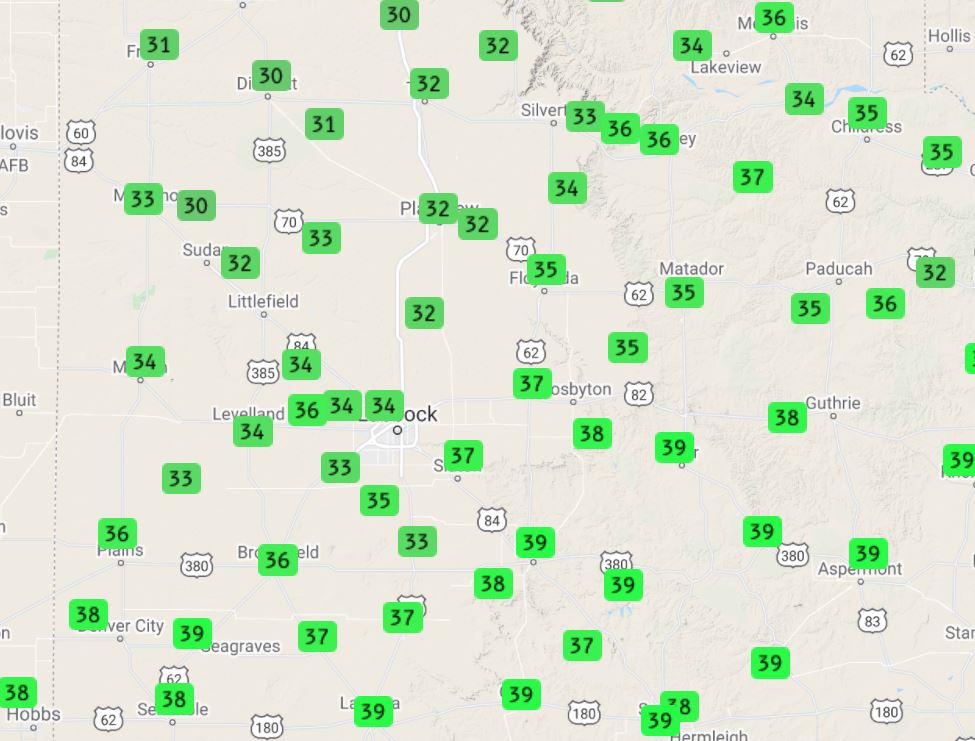
| Low temperatures observed on Saturday morning (28 November 2020). The data are courtesy of the West Texas Mesonet. | |
| Where it was "warmer", a welcome cold rain fell over much of the South Plains, southeast Texas Panhandle and Rolling Plains. Rain totals of a few hundredths to a few tenths of an inch were measured on the Caprock, while even higher totals were found in the Rolling Plains. A steady rain provided totals near and above a half inch roughly along and east of a Childress to Spur to Fluvanna line. Eastern parts of King and Stonewall Counties into western North Texas recorded totals in excess of an inch, impressive for a winter storm. The Aspermont West Texas Mesonet site measured 1.50 inches of rain over the course of the event. | |
 |
|
| Regional radar animation valid from 6:18 am to 7:28 am on November 28th. Additional regional radar animations can be found at: 11:38 am to 12:48 pm; and 7:18 pm to 8:28 pm. | |
| The more intense precipitation quickly diminished from west-to-east Saturday afternoon and dry air aloft (referred to as a dry slot) overspread the South Plains on the south side of the upper level low. However, a little light precipitation, mostly in the form of rain showers and sprinkles, did wrap southward across parts of the southern Texas Panhandle and northern South Plains late Saturday evening into early Sunday morning as the tightly wound storm system moved across the Texas Panhandle and into western Oklahoma. | |
 |
|
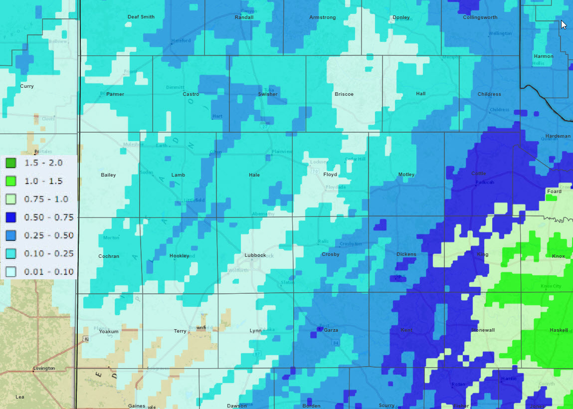
| 2-day radar-estimated and bias-corrected rainfall ending at noon on 29 November 2020. The precipitation measured by the West Texas Mesonet over this same stretch can be VIEWED HERE. | |
| Officially Lubbock only recorded 0.06 inches with this event (and a trace of sleet), though it did triple the total rainfall for the month. Childress fared better, measuring 0.35 inches. This bout of precipitation finished what was otherwise another dry month in 2020. | |

