|
September starts on a bumpy note for some |
|
 |
|
| Severe supercell thunderstorm west of Lakeview Tuesday afternoon (1 September 2020). The picture is courtesy of Alex Schueth. | |
|
September began on the warm and unsettled note. Temperatures soared into the upper 80s to middle and upper 90s. The heat combined with plenty of moisture and an approaching upper level system to spark isolated to widely scattered thunderstorms Tuesday afternoon (1 September). The most robust storm of the day developed across the southwest Texas Panhandle, then tracked steadily east, then southeastward through the evening hours. The rotating storm produced two brief tornadoes, one northeast of Antelope Flats and a second southwest of Lesley. The West Texas Mesonet (WTM) site near Lesley also recorded a peak wind gust of 62 mph. Thankfully, the brief tornadoes caused no known damage. |
|
 |
|
| Lubbock radar animation valid from 5:52 pm to 7:22 pm on 1 September 2020. | |
| In addition to the severe weather, the more intense activity dropped very heavy rain. Several spots across the southeast Texas Panhandle recorded 1 to 2+ inches of rain, much of which fell in a short amount of time. The heavy rain did cause localized flooding, as seen in the picture below. | |
 |
|
| Flooded County Road 26 west of Estelline Tuesday evening (1 September 2020). The picture is courtesy of Farrah Holcomb. | |
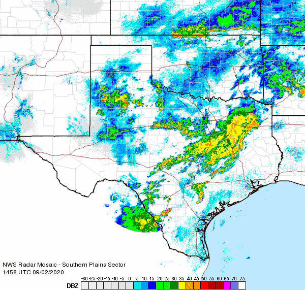
| The activity gradually shifted to the east of the Rolling Plains after midnight, but then redeveloped early Wednesday morning as the upper level system tracked directly over the South Plains. A few of these slow-moving storms became strong, dropping very heavy rain and even brief small pockets of pea-sized hail. The heaviest rain from this activity was centered across the central South Plains, though largely missed the city of Lubbock. | |
 |
|
| Regional radar animation valid from 8:58 am to 10:08 am on 2 September 2020. An additional radar animation, valid from 4:48 am to 5:58 am on the 2nd can be VIEWED HERE. | |
| The Wednesday morning activity faded by midday, but one final round of the showers and thunderstorms did dive southward across the eastern Texas Panhandle into the Rolling Plains late Wednesday afternoon into the early evening hours. One particularly strong storm produced a wind gust to 59 mph at the Memphis WTM, where it also dumped nearly an inch of rain in about 20 minutes. The torrential rain did cause flooding along Highway 287 in and around Memphis. | |
|
|
|
 |
|
| 3-day radar-estimated and bias corrected rainfall ending at 8 am on Wednesday (3 September 2020). A regional view of the same information can be ACCESSED HERE. The West Texas Mesonet measured 3-day rainfall totals over this same period can be FOUND HERE. | |
|
Over the course of the first couple of days of September most of the South Plains region received at least a little rain. The heaviest rain, near and above an inch, favored the southeast Texas Panhandle, southern Rolling Plains and locations north and east of Lubbock. Although the city of Lubbock largely missed out on the rain, the Lubbock Airport did record 0.81 inches, most of which fell in a brief burst Wednesday morning. The Childress Airport recorded 0.96 inches over the same stretch. The preliminary storm reports for this active early September can be viewed below. |
PRELIMINARY LOCAL STORM REPORT
NATIONAL WEATHER SERVICE LUBBOCK TX
754 PM CDT TUE SEP 01 2020

..TIME...   ...EVENT...      ...CITY LOCATION...     ...LAT.LON...
..DATE...   ....MAG....      ..COUNTY LOCATION..ST.. ...SOURCE....
            ..REMARKS..

0645 PM     TORNADO          3 NNE ANTELOPE FLATS    34.65N 100.97W
09/01/2020                   BRISCOE            TX   STORM CHASER

            REPORT OF A WEAK TORNADO

0708 PM     TSTM WND GST     2 S LESLEY              34.65N 100.81W
09/01/2020  M62 MPH          HALL               TX   MESONET

0710 PM     TORNADO          8 SSW LESLEY            34.56N 100.85W
09/01/2020                   HALL               TX   STORM CHASER

            REPORT OF A WEAK TORNADO

