|
Mid-August record heat fuels scattered severe storms |
|||||||||||
 |
|||||||||||
| Severe supercell thunderstorm south of Memphis Sunday afternoon (16 August 2020). The picture is courtesy of Marcus Diaz. | |||||||||||
|
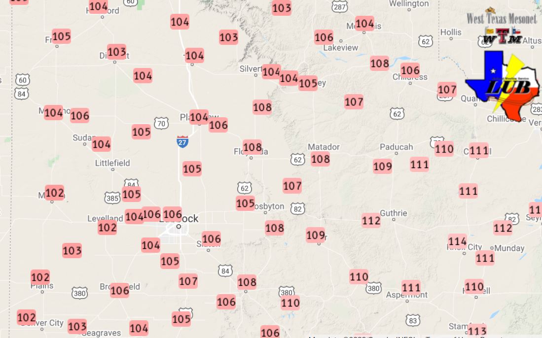
Hot temperatures were the theme through much of the first two thirds of August. Highs in the upper 90s and triple digits were common, peaking during the middle of the month when temperatures ventured well above 100 degrees. Lubbock hit 107 degrees on August 13th and 14th, tying and setting a new record, respectively. Just as impressive, Lubbock set record maximum low temperatures three mornings in a row, from the 12th through the 14th, when lows only dropped to 78, 75 and 80 degrees. Although Childress didn't set any new records, they got as hot as 109 degrees on August 13th. Several spot off the Caprock, including Paducah, Guthrie and Aspermont got as hot as 112 degrees over this ridiculous stretch. |
|||||||||||
 |
|||||||||||
| High temperatures observed Sunday (16 August 2020). The data are courtesy of the West Texas Mesonet. | |||||||||||
| August 16th wasn't quite as hot as the previous few days, but it was still hot, as can be seen above. As mid-level moisture infiltrated the region, the intense heat led to several rounds of isolated to scattered afternoon and evening thunderstorms. The thunderstorm coverage and intensity peaked on Sunday, the 16th, when a large complex of thunderstorms developed across the southeast Texas Panhandle. | |||||||||||
 |
|||||||||||
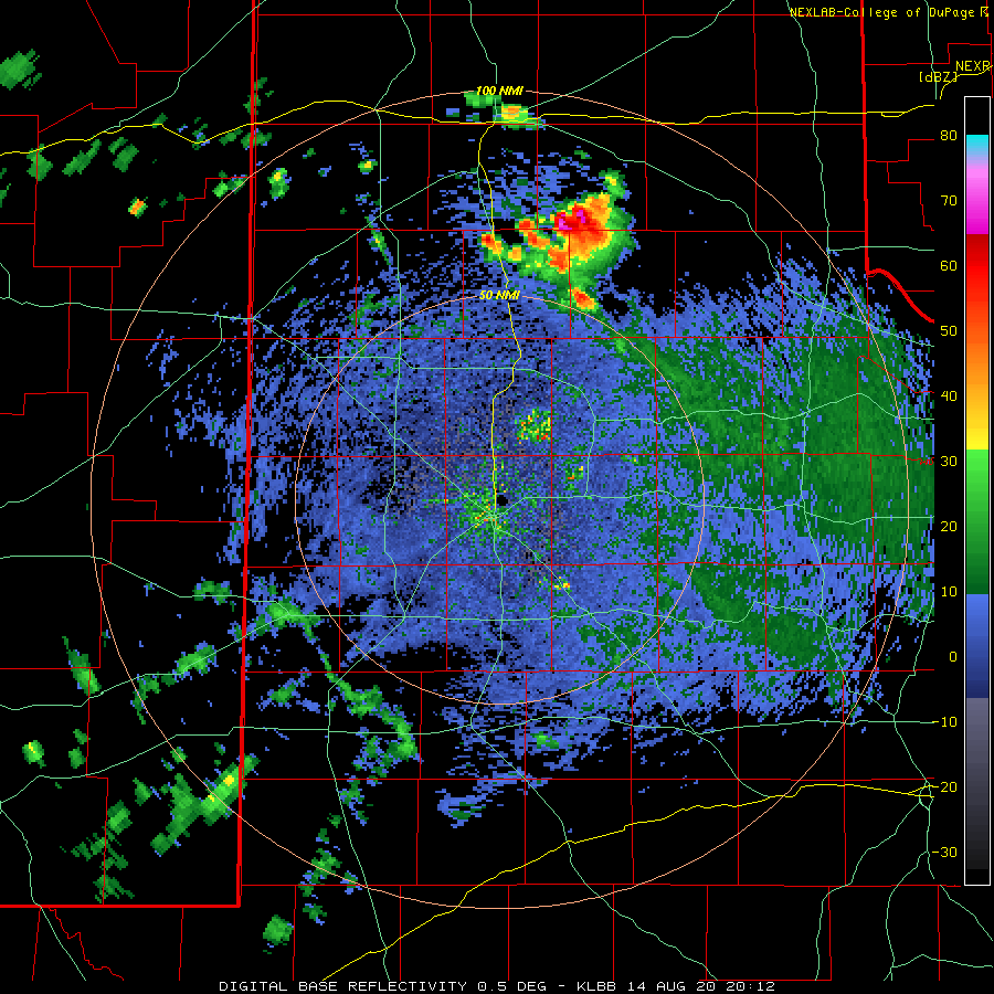
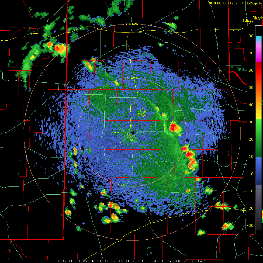
| Lubbock radar animation valid from 3:12 pm to 9:40 pm on 16 August 2020. Regional radar animations for this same evening can be viewed at: 4:18 pm to 5:28 pm on the 16th; and 5:18 pm to 6:28 pm on the 16th. | |||||||||||
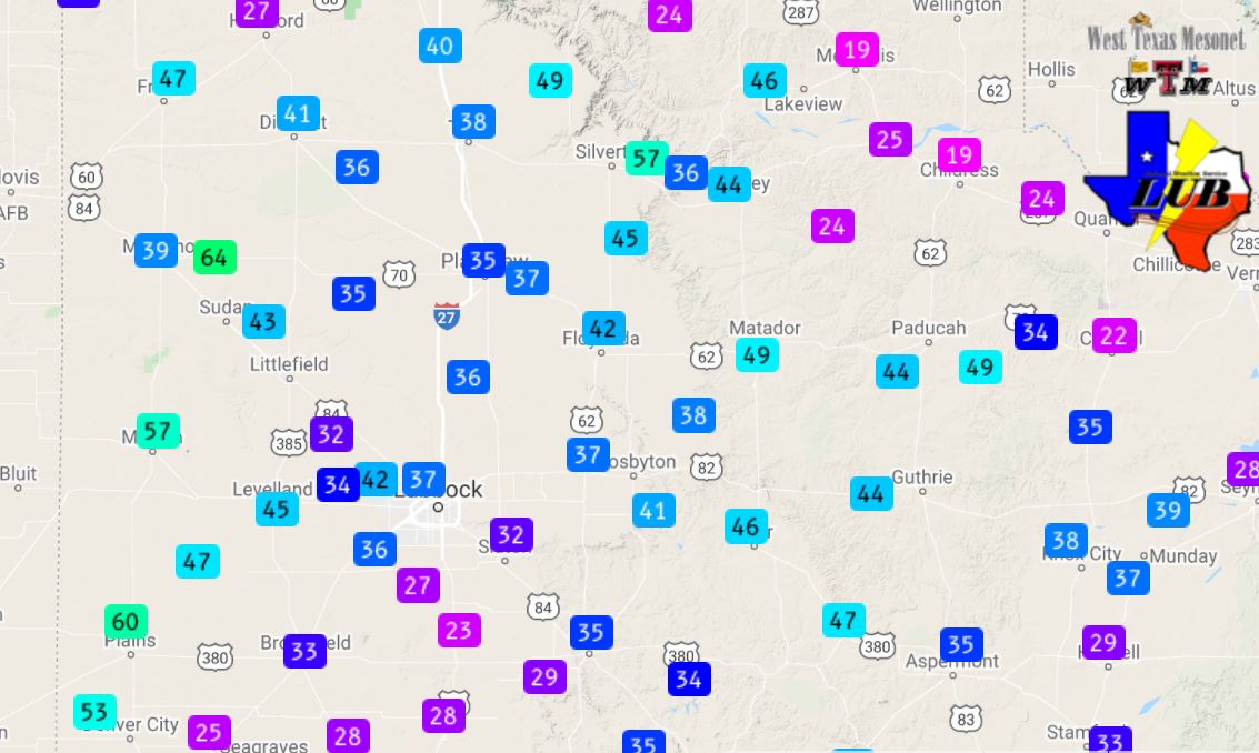
| The thunderstorm complex moved south and southeastward through the late afternoon and evening hours, producing widespread severe winds and locally heavy rain across the southeast Texas Panhandle and northern Rolling Plains. Peak wind gusts of 60 to 70 mph were common with this activity (see below), though the Hackberry West Texas Mesonet (WTM) site recorded a gust of 78 mph, and the Seymour site a gust to 86 mph. | |||||||||||
 |
|||||||||||
| Peak wind gusts recorded by the West Texas Mesonet Sunday afternoon and evening (16 August 2020). The peak sustained wind speeds measured on the 16th can be VIEWED HERE. | |||||||||||
| The complex of severe thunderstorms, as well as non-severe storms over the southern Rolling Plains, sent gusty outflow winds westward across the Caprock Sunday evening. These winds kicked up a bit of dust, but they also carried in much cooler air, providing a relief from the intense heat as temperatures plunged into the 70s. | |||||||||||
 |
|||||||||||
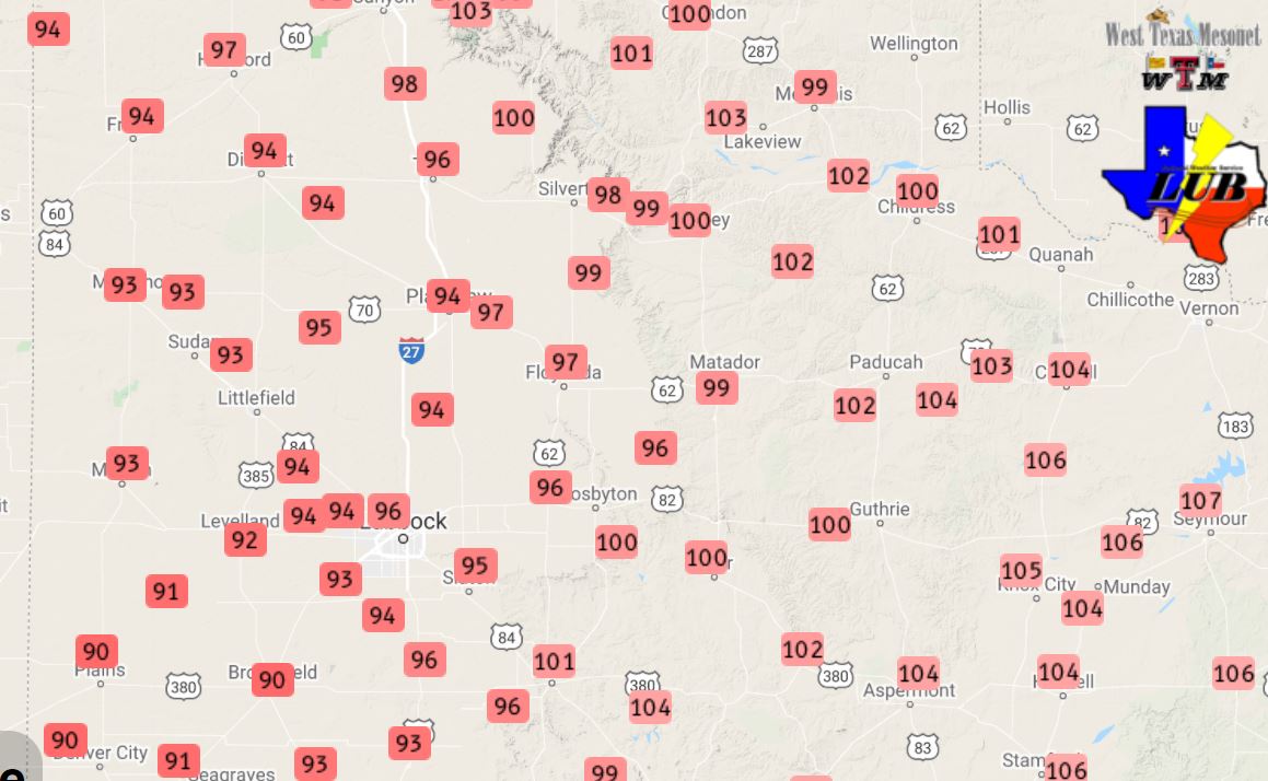
| High temperatures observed Friday (14 August 2020). The data are courtesy of the West Texas Mesonet. | |||||||||||
|
|||||||||||
| Outflow winds from Friday's thunderstorms generally peaked in the 35 to 50 mph range (see below). However, a few locations across the western South Plains recorded wind gusts between 55 and 65 mph as weakening showers and thunderstorms plunged southward. | |||||||||||
 |
|||||||||||
| Peak wind gusts recorded by the West Texas Mesonet Friday afternoon and evening (14 August 2020). | |||||||||||
| The next afternoon, Saturday (15 August), brought another hot afternoon which sparked scattered thunderstorm development during the late afternoon hours. A Lubbock radar animation, valid from 3:42 pm to 5:15 pm on the 15th, can be VIEWED HERE. This activity, which was spotty and short-lived, provided a few locations with a little rainfall and gusty rain-cooled outflow. | |||||||||||
 |
|||||||||||
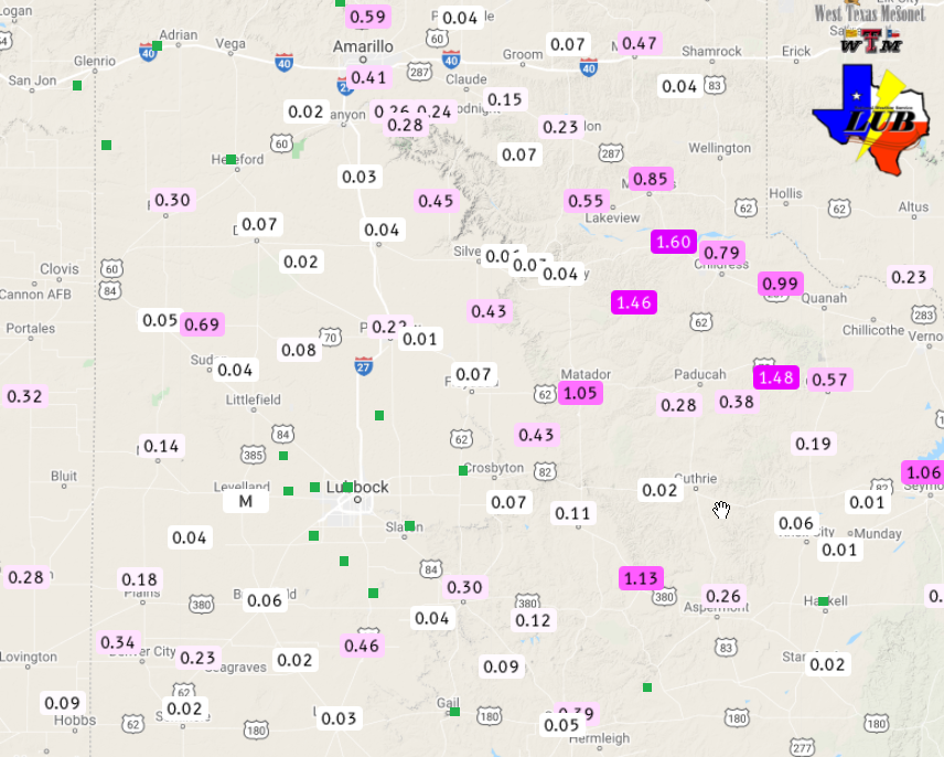
| 7-day radar-estimated and bias corrected rainfall ending at 3 pm on Tuesday (18 August 2020). The West Texas Mesonet measured 6-day rainfall totals ending at 7 pm on the 18th can be FOUND HERE. | |||||||||||
|
Through the course of this hot stretch, most of the region did see at least a little rain. The biggest rainfall winners were over the southeast Texas Panhandle and northern Rolling Plains, pockets of the southern Rolling Plains and the western part of Cochran County where an inch or more of rain fell. The Childress Airport was the big winner, recording 2.38 inches on the 16th, setting a daily rainfall record in the process. Unfortunately, locations in and around Lubbock County largely missed out. The preliminary storm reports for this active mid-August can be viewed below. |
PRELIMINARY LOCAL STORM REPORT...SUMMARY
NATIONAL WEATHER SERVICE LUBBOCK TX
1004 PM CDT SUN AUG 16 2020

..TIME...   ...EVENT...      ...CITY LOCATION...     ...LAT.LON...
..DATE...   ....MAG....      ..COUNTY LOCATION..ST.. ...SOURCE....
            ..REMARKS..

0416 PM     TSTM WND GST     2 S LESLEY              34.65N 100.81W
08/16/2020  M65 MPH          HALL               TX   MESONET

0422 PM     TSTM WND GST     2 S LESLEY              34.65N 100.81W
08/16/2020  M67 MPH          HALL               TX   MESONET

0432 PM     TSTM WND GST     2 S LESLEY              34.65N 100.81W
08/16/2020  M63 MPH          HALL               TX   MESONET

0440 PM     TSTM WND GST     1 NE MEMPHIS            34.73N 100.53W
08/16/2020  M67 MPH          HALL               TX   MESONET

0445 PM     TSTM WND GST     1 NE MEMPHIS            34.73N 100.53W
08/16/2020  M65 MPH          HALL               TX   MESONET

0450 PM     TSTM WND GST     1 NE MEMPHIS            34.73N 100.53W
08/16/2020  M58 MPH          HALL               TX   MESONET

0455 PM     TSTM WND GST     1 S NORTHFIELD          34.27N 100.60W
08/16/2020  M61 MPH          MOTLEY             TX   MESONET

0505 PM     TSTM WND GST     1 S NORTHFIELD          34.27N 100.60W
08/16/2020  M58 MPH          MOTLEY             TX   MESONET

0506 PM     TSTM WND GST     2 S LESLEY              34.65N 100.81W
08/16/2020  M65 MPH          HALL               TX   MESONET

0510 PM     TSTM WND GST     1 S NORTHFIELD          34.27N 100.60W
08/16/2020  M65 MPH          MOTLEY             TX   MESONET

0515 PM     TSTM WND GST     3 SSE ESTELLINE         34.50N 100.42W
08/16/2020  M69 MPH          HALL               TX   MESONET

0515 PM     TSTM WND GST     1 S NORTHFIELD          34.27N 100.60W
08/16/2020  M62 MPH          MOTLEY             TX   MESONET

0530 PM     TSTM WND GST     10 SW PADUCAH           33.89N 100.40W
08/16/2020  M62 MPH          COTTLE             TX   MESONET

0531 PM     HAIL             3 S ESTELLINE           34.50N 100.44W
08/16/2020  E1.00 INCH       HALL               TX   TRAINED SPOTTER

0535 PM     TSTM WND GST     10 SW PADUCAH           33.89N 100.40W
08/16/2020  M65 MPH          COTTLE             TX   MESONET

0549 PM     TSTM WND GST     2 SSE HACKBERRY         33.90N 100.13W
08/16/2020  M61 MPH          COTTLE             TX   MESONET

0553 PM     TSTM WND GST     2 SSE HACKBERRY         33.90N 100.13W
08/16/2020  M78 MPH          COTTLE             TX   MESONET

0600 PM     TSTM WND GST     10 SW PADUCAH           33.89N 100.40W
08/16/2020  M58 MPH          COTTLE             TX   MESONET

0755 PM     TSTM WND GST     2 SSE HACKBERRY         33.90N 100.13W
08/16/2020  M61 MPH          COTTLE             TX   MESONET

