| Large hail falls near Post and pounds parts of Lubbock 20 May 2020 |
|||||
 |
|||||
| Large hail that fell near Post Wednesday evening (20 May 2020). The image is courtesy of Brett Adair. | |||||
|
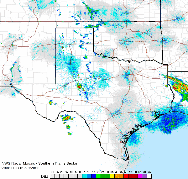
The dryline served as the focus for the development of scattered thunderstorm late Wednesday afternoon (20 May). Hot temperatures, sufficient moisture, strong instability and enough wind shear allowed some of the storms to organize, become severe and generating large hail. |
|||||
 |
|||||
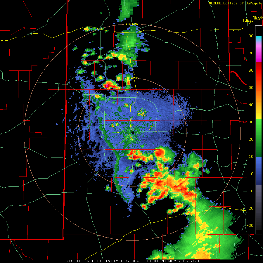
| Lubbock radar animation valid from 6:21 PM to 7:11 PM on 20 May 2020. | |||||
| The initial thunderstorms formed over the southwest Texas Panhandle and northwest South Plains as well southeastern South Plains. Ping pong ball size hail fell from a storm that passed just to the west of Dimmitt, while tennis ball size hail was observed with the storm northwest of Post (see the picture at the top of this page). | |||||
 |
|||||
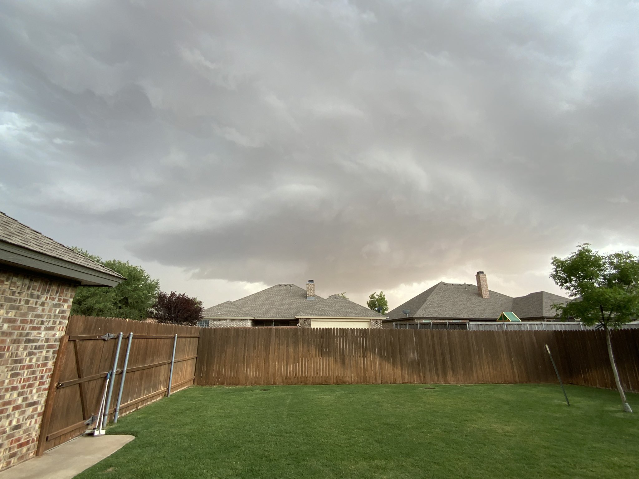
| Supercell thunderstorm approaching Lubbock from the south Wednesday evening (20 May 2020). The picture was taken near Quaker Avenue and 123rd Street and is courtesy of @RBrandisCrisis. | |||||
|
|||||
 |
|||||
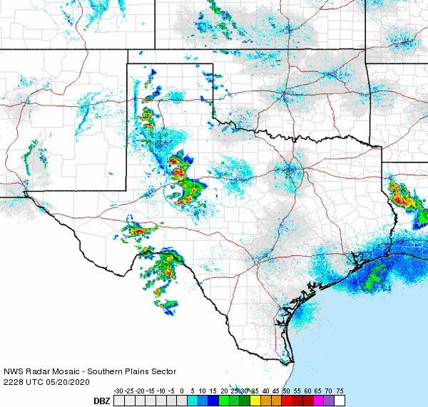
| Regional radar animation valid from 5:28 pm to 6:38 pm on 20 May 2020. Additional regional radar animations can be viewed at: 3:38 pm to 4:48 pm; and 6:48 pm to 7:58 pm on 20 May 2020. | |||||
| Interestingly, many locations experienced only hail initially as the storm moved into the city, though the hail did gradually mix with rain too. Unfortunately, the large hail damaged and destroyed many plants, vehicles and roofs. Numerous vehicle windows were shattered, and most objects that were exposed to the giant hail incurred some kind of damage. | |||||
 |
|||||
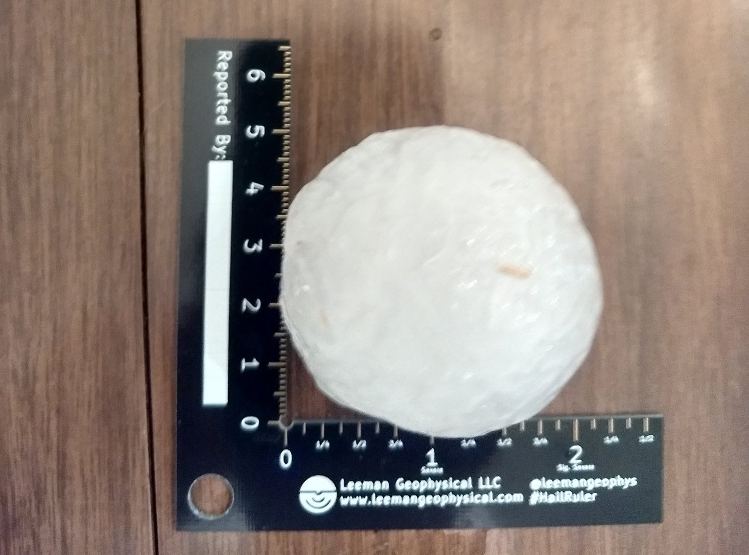
| Large hail that fell in south Lubbock (near 93rd Street and Slide Avenue) on 20 May 2020. The image is courtesy of Mark Conder. | |||||
|
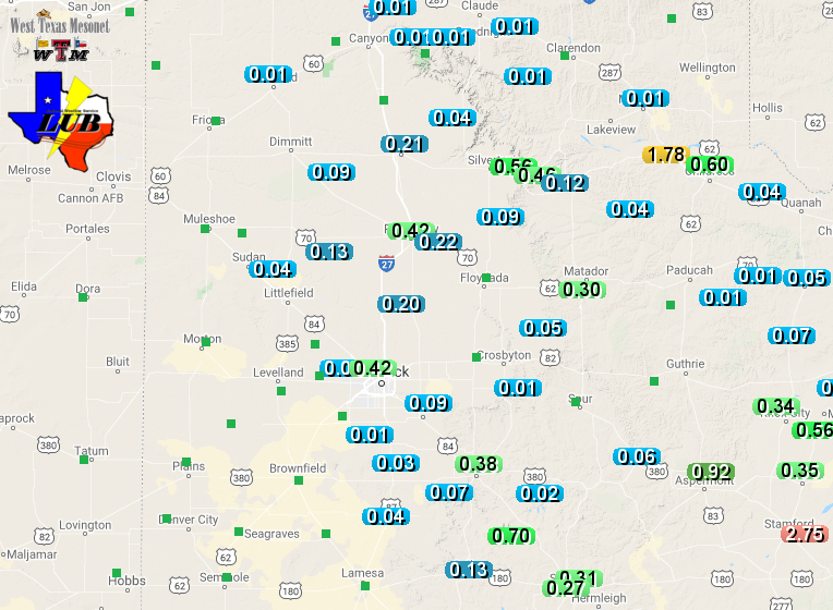
Aside from the hail, many locations from the central South Plains into the southern Texas Panhandle and Rolling Plains received at least a little rainfall. The rain was heaviest in a several pockets, favoring the southern Texas Panhandle as well as the southern Texas Panhandle. |
|||||
 |
|||||
| 24-hour radar-estimated and bias-corrected rain totals ending at 7 AM on Thursday (21 May). Rain totals measured by the West Texas Mesonet over this same time can be VIEWED HERE. | |||||
| Officially, the Lubbock Airport recorded 0.42 inches of rain on May 20th, while the Childress Airport picked up a quick 0.96 inches. | |||||
| The preliminary wind and storm reports from this active May day can be viewed below. |
PRELIMINARY LOCAL STORM REPORT...SUMMARY
NATIONAL WEATHER SERVICE LUBBOCK TX
1214 AM CDT THU MAY 21 2020

..TIME...   ...EVENT...      ...CITY LOCATION...     ...LAT.LON...
..DATE...   ....MAG....      ..COUNTY LOCATION..ST.. ...SOURCE....
            ..REMARKS..

0450 PM     HAIL             4 W DIMMITT             34.55N 102.39W
05/20/2020  M1.50 INCH       CASTRO             TX   TRAINED SPOTTER

0458 PM     HAIL             5 W DIMMITT             34.55N 102.40W
05/20/2020  M1.25 INCH       CASTRO             TX   PUBLIC

0600 PM     HAIL             3 NW POST               33.22N 101.42W
05/20/2020  E2.50 INCH       GARZA              TX   LAW ENFORCEMENT

0646 PM     HAIL             3 NW WOODROW            33.47N 101.89W
05/20/2020  M1.75 INCH       LUBBOCK            TX   NWS EMPLOYEE

0647 PM     HAIL             3 NW WOODROW            33.47N 101.89W
05/20/2020  M2.75 INCH       LUBBOCK            TX   NWS EMPLOYEE

0648 PM     HAIL             2 S LUBBOCK SOUTH PLAI  33.50N 101.93W
05/20/2020  E1.00 INCH       LUBBOCK            TX   PUBLIC

0651 PM     HAIL             LUBBOCK SOUTH PLAI      33.53N 101.92W
05/20/2020  E1.25 INCH       LUBBOCK            TX   PUBLIC

0657 PM     HAIL             1 SW LUBBOCK            33.56N 101.88W
05/20/2020  M2.25 INCH       LUBBOCK            TX   NWS EMPLOYEE

0657 PM     HAIL             8 SW LUBBOCK            33.50N 101.97W
05/20/2020  M2.00 INCH       LUBBOCK            TX   NWS EMPLOYEE

0700 PM     HAIL             MULKEY                  34.46N 102.21W
05/20/2020  M1.00 INCH       CASTRO             TX   PUBLIC

0700 PM     HAIL             4 W TEXAS TECH UNIV.    33.58N 101.93W
05/20/2020  E1.50 INCH       LUBBOCK            TX   PUBLIC

0705 PM     HAIL             TEXAS TECH UNIV.        33.58N 101.86W
05/20/2020  E1.75 INCH       LUBBOCK            TX   PUBLIC

0719 PM     HAIL             6 NNE LUBBOCK           33.67N 101.82W
05/20/2020  M2.00 INCH       LUBBOCK            TX   WX OBSERVER FAA

0724 PM     HAIL             1 WNW LUBBOCK           33.58N 101.90W
05/20/2020  M1.75 INCH       LUBBOCK            TX   SOCIAL MEDIA

0733 PM     HAIL             ABERNATHY               33.83N 101.84W
05/20/2020  E1.25 INCH       HALE               TX   PUBLIC

0745 PM     HAIL             ROUNDUP                 33.76N 102.10W
05/20/2020  E1.25 INCH       HOCKLEY            TX   PUBLIC

0748 PM     HAIL             2 SSE BROADVIEW         33.61N 101.92W
05/20/2020  E3.00 INCH       LUBBOCK            TX   SOCIAL MEDIA

0800 PM     HAIL             10 S PLAINVIEW          34.05N 101.72W
05/20/2020  E1.00 INCH       HALE               TX   PUBLIC

0844 PM     HAIL             LIDER                   34.18N 101.63W
05/20/2020  E1.50 INCH       HALE               TX   PUBLIC

1011 PM     HAIL             3 S ESTELLINE           34.50N 100.44W
05/20/2020  M1.00 INCH       HALL               TX   EMERGENCY MNGR

