| Mid-May brings severe storms, rain and strong winds 7-15 May 2020 |
|||||||||||
 |
|||||||||||
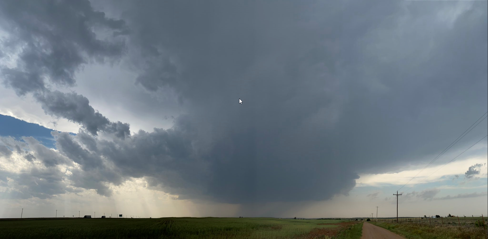
| Supercell thunderstorm northwest of Childress Thursday evening (7 May 2020). The image is courtesy of Trey Greenwood. | |||||||||||
|
After a prolonged stretch of relatively quiet and mostly dry weather since mid-March, the weather turned more active in mid-May. The activity kicked off with an intense, but isolated, supercell thunderstorm that affected the southeast Texas Panhandle Thursday evening, May 7th. |
|||||||||||
 |
|||||||||||
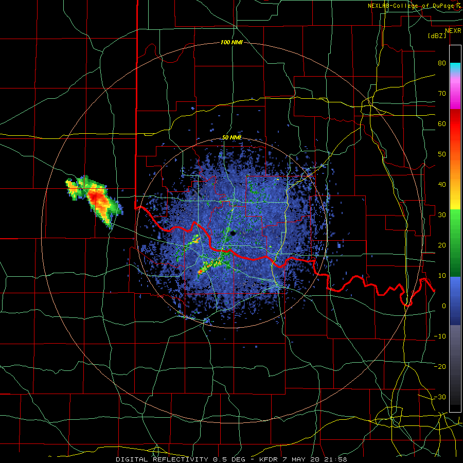
| Lubbock radar animation valid from 4:58 pm to 5:47 pm on 7 May 2020. An additional regional radar animation, valid from 4:08 pm to 5:18 pm can be FOUND HERE. | |||||||||||
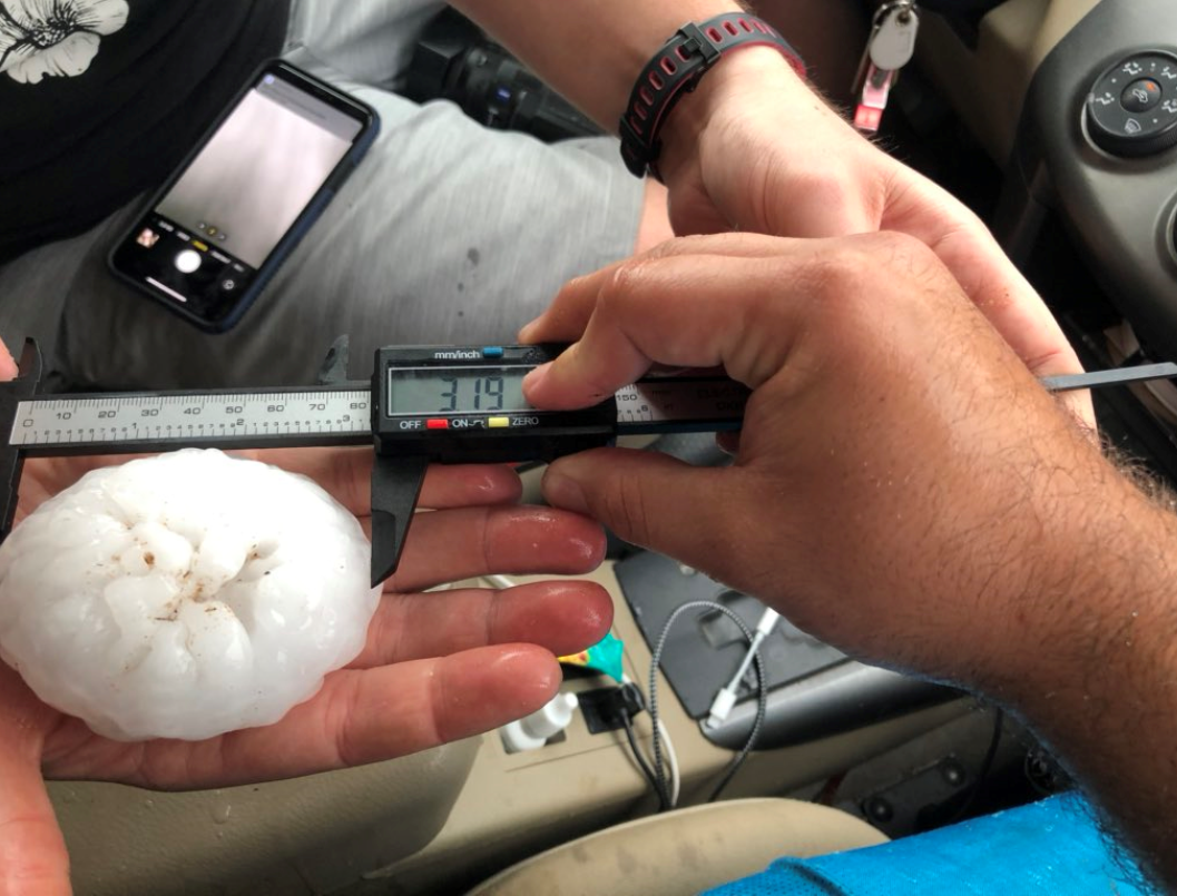
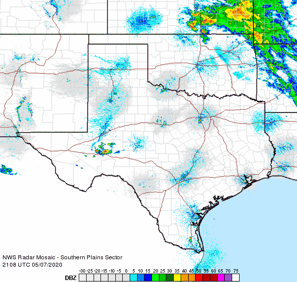
| A lone storm erupted late Thursday afternoon southwest of Memphis and tracked steadily eastward across northern Childress County. While doing so, it did shed another storm that moved northeastward into southwest Oklahoma. Very strong instability and moderate wind shear allowed the storms to quickly become severe and start rotating in the middle levels of the atmosphere. The result was that the storms generated giant hail and brief heavy rainfall. | |||||||||||
 |
|||||||||||
| Giant hail that fell north of Childress along Highway 62 Thursday evening (7 May 2020). The picture is courtesy of Trey Greenwood. A second picture of large hail, collected near Highway 83 and FM 286 in northern Childress County (courtesy of Steve Kersh), can be VIEWED HERE. | |||||||||||
|
|||||||||||
| A strong May cold front followed late Thursday night and early Friday morning. Northerly winds gusting to 45 to 60+ mph were common immediately behind this front. The gusty winds, albeit not quite as strong as during the overnight hours, continued through much of the day Friday. These northerly winds carried in much cooler air too, with daytime highs mostly in the 60s on Friday. | |||||||||||
 |
|||||||||||
| Regional radar animation valid from 7:38 pm to 8:48 pm on 11 May 2020. | |||||||||||
| Pleasant and dry weather followed on the weekend, but that eventually changed as moisture gradually returned to region early the next week. The improving moisture, combined with an approaching upper level disturbance, caused widespread thunderstorms to develop and move across the South Plains region late Monday afternoon through the evening/overnight (11 May). | |||||||||||
 |
|||||||||||
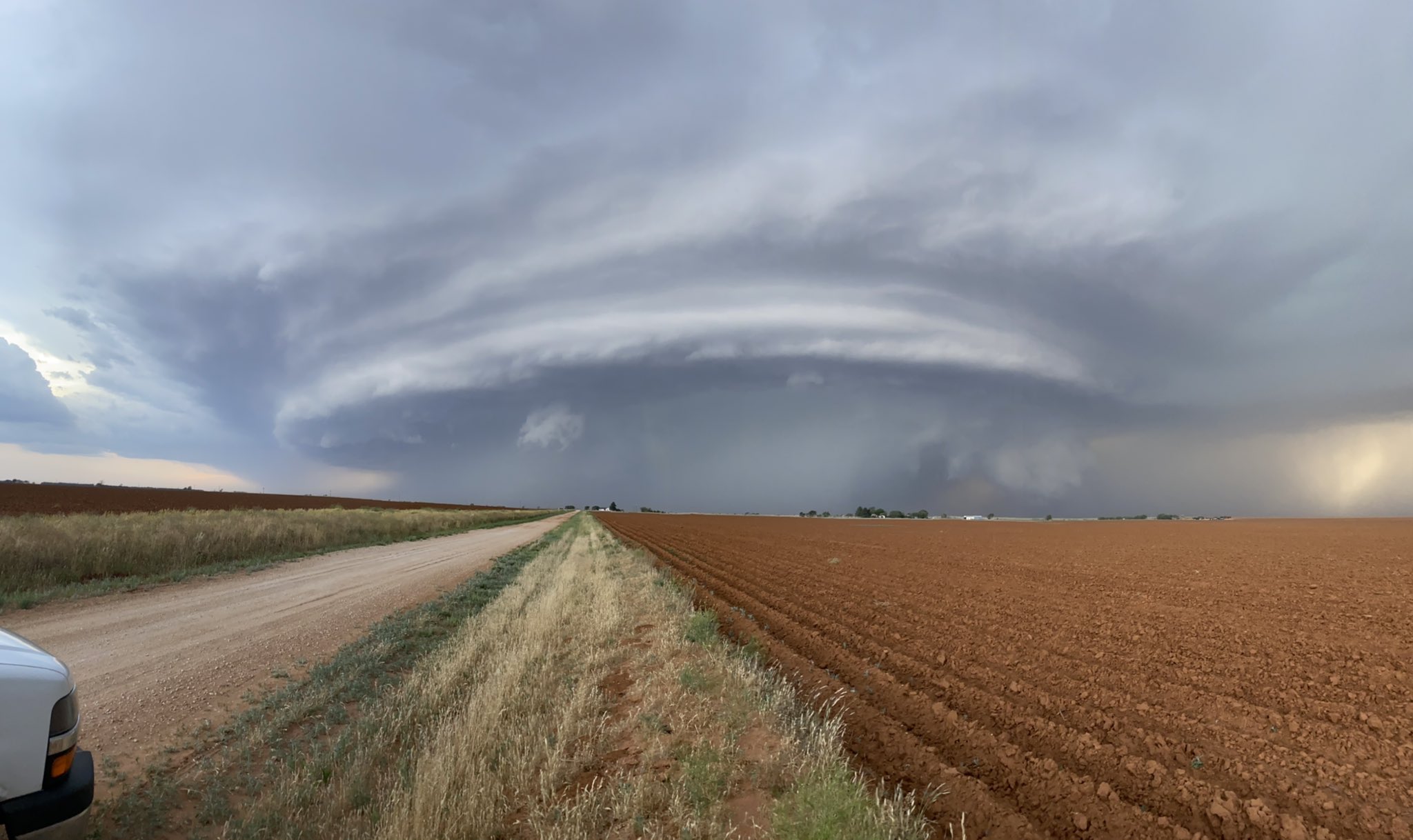
| Impressive view of an intense thunderstorm from north of Littlefield around 8 pm on 11 May 2020. The image is courtesy of @inFLIGHTout. | |||||||||||
|
Instability wasn't as strong as the previous Thursday, but it was still sufficient to allow a few of the storms to become severe. Hail as large as golf balls was reported near Levelland, and outflow winds caused damage in and around Woodrow and New Home. |
|||||||||||
 |
|||||||||||
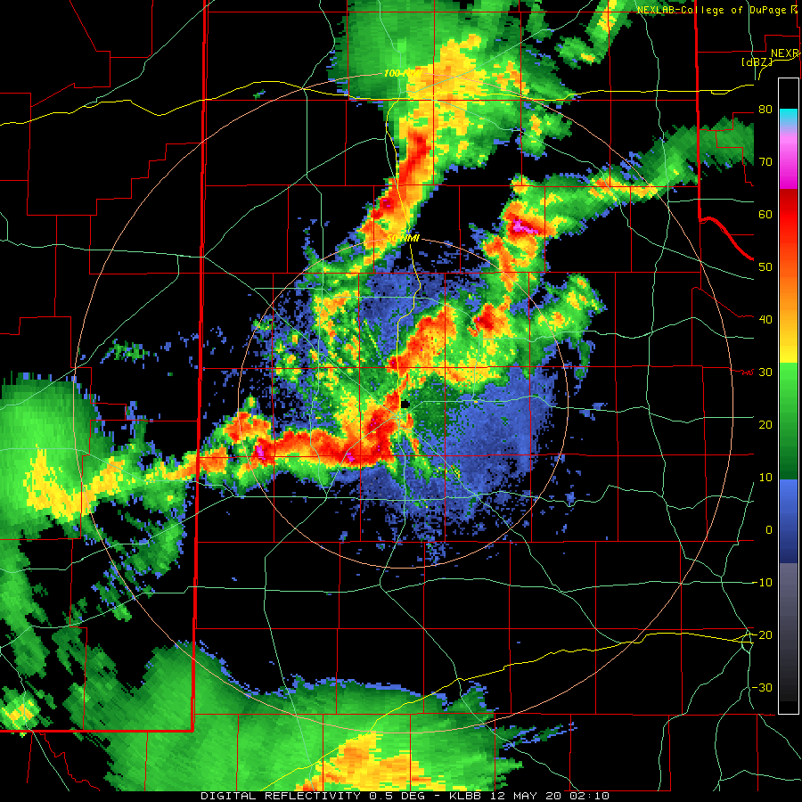
| Lubbock radar animation valid from 9:10 pm to 9:32 pm on 11 May 2020. | |||||||||||
| The thunderstorm activity made for interesting and ominous sights, while also providing welcome rainfall for much of the region. This may have been especially true in and around Lubbock as the thunderstorms moved through almost exactly 50 years, to the hour, after the destructive 1970 Lubbock tornado. | |||||||||||
 |
|||||||||||
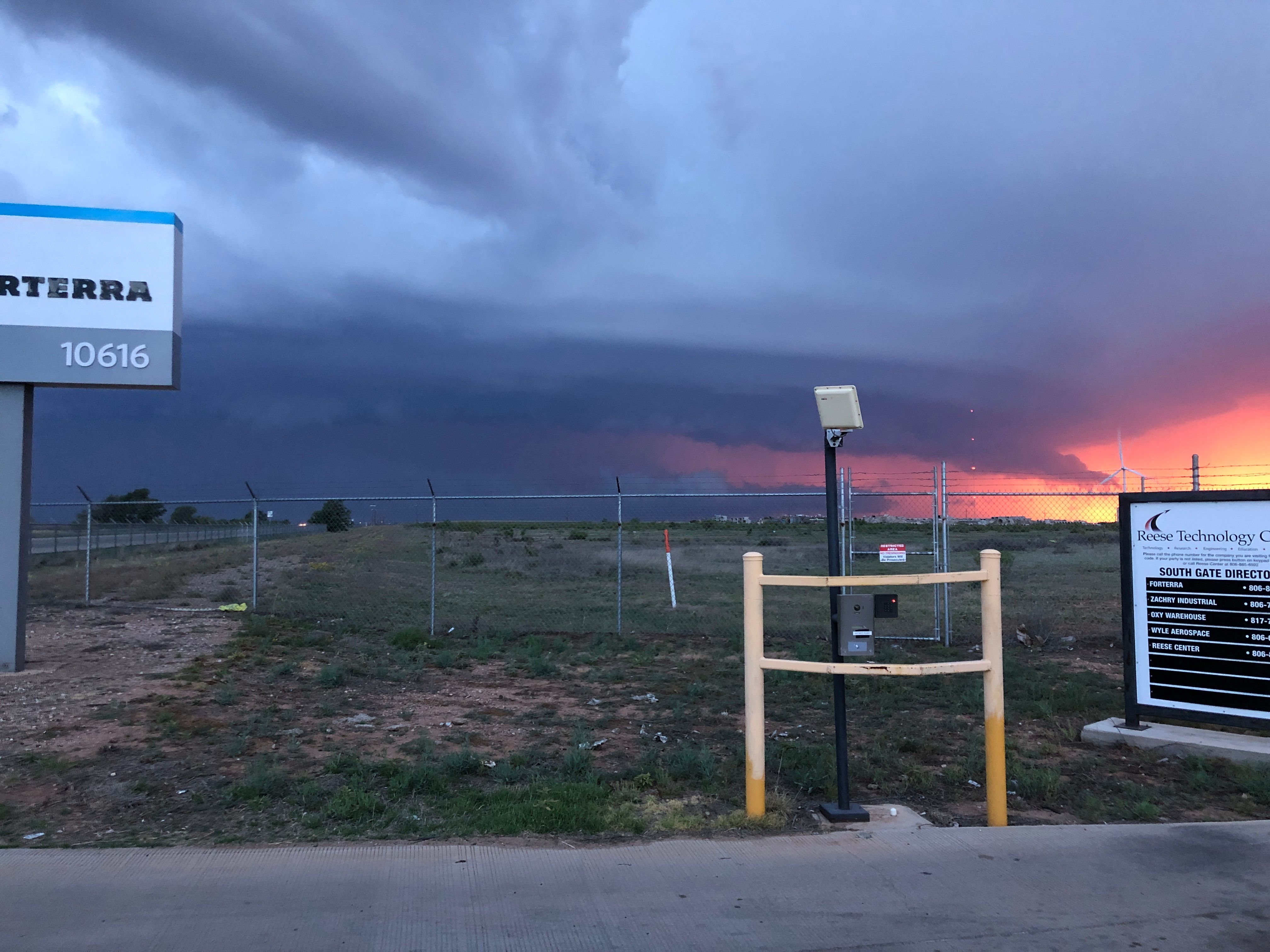
| Looking west at the line of storms as they approached Lubbock on Monday evening (11 May). This picture was taken by Alan Martin. | |||||||||||
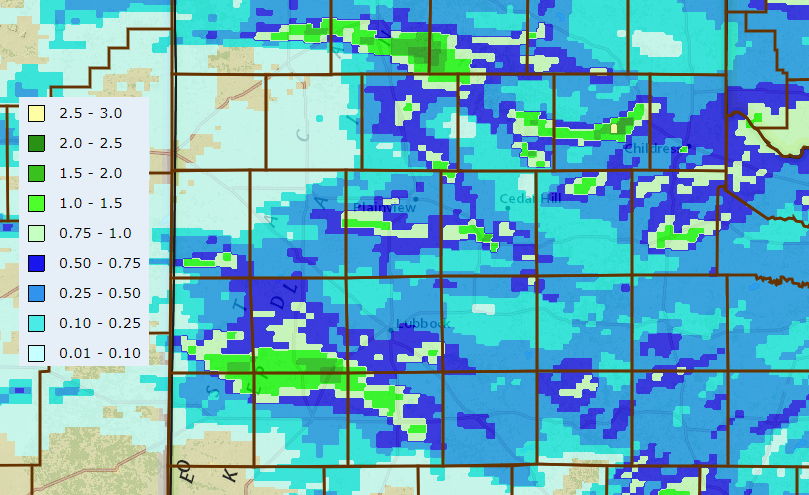
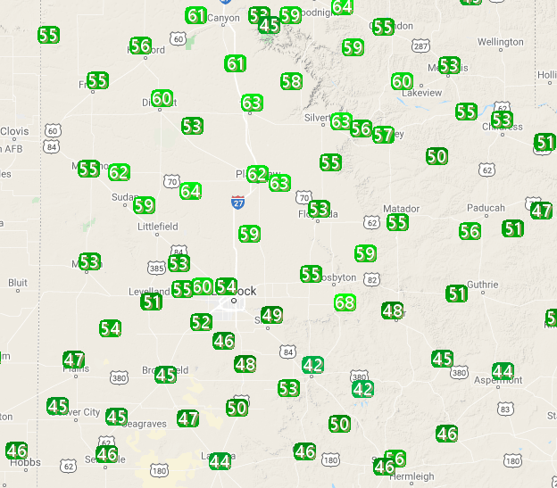
| Nearly the entire region recorded at least a little rainfall, and several locations received significant rainfall near or in excess of an inch. Officially, Lubbock measured 0.42", while southern parts of the city received anywhere from a half inch to near an inch. Childress officially recorded 0.49". | |||||||||||
 |
|||||||||||
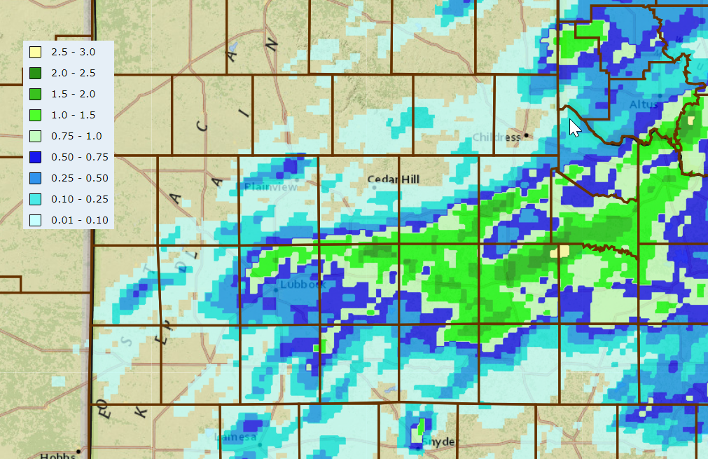
| 24-hour radar-estimated and bias-corrected rain totals ending at 10 am on Tuesday (12 May). Rain totals measured by the West Texas Mesonet over this same time can be VIEWED HERE. | |||||||||||
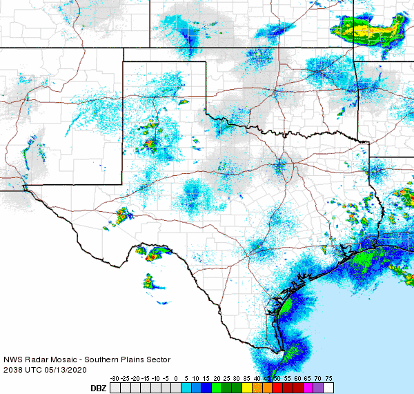
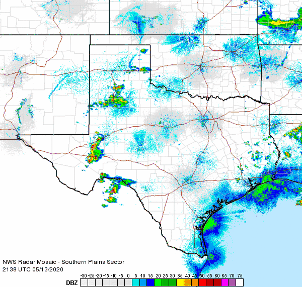
| The following day remained relatively cool for most of the South Plains region and thunderstorms failed to develop. That changed the next afternoon as temperatures heated up into the lower and middle 90s. The heat, along with a diffuse dryline and approaching upper level disturbance, sparked another round of thunderstorms for much of the central and eastern South Plains and much of the Rolling Plains Wednesday afternoon and evening (13 May). | |||||||||||
 |
|||||||||||
| Regional radar animation valid from 5:38 pm to 6:48 pm on 13 May 2020. Additional regional radar animations can be found at: 3:38 pm to 4:48 pm; 4:38 pm to 5:48 pm; and 6:48 pm to 7:58 pm. | |||||||||||
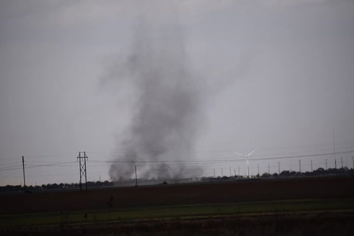
| The initial thunderstorm activity was somewhat disorganized, but was intense enough to produce pockets of hail, some as large as quarters to ping pong ball size. The rain and hail cooled air also generated numerous strong to severe wind gusts which kicked up blowing dust too. | |||||||||||
 |
 |
||||||||||
| (left) A gustnado observed south of Wolfforth Wednesday afternoon. The picture is courtesy of Chad Casey and KCBD. (right) Hail that fell near 90th and Slide in Lubbock Wednesday evening. The image is courtesy of Barry Auer. | |||||||||||
| Eventually the scattered thunderstorms amalgamated into a line and accelerated eastward through the Rolling Plains and into western North Texas during the late evening hours. Several reports of small hail, strong to severe wind gusts and very heavy rainfall were received as the line moved through. | |||||||||||
 |
|||||||||||
| Regional radar animation valid from 8:18 pm to 9:28 pm on 13 May 2020. | |||||||||||
| The high-based thunderstorms resulted in many impressive views Wednesday afternoon and evening. As the sun dipped toward the horizon, the views included the magnificent rainbows displayed below. | |||||||||||
 |
|||||||||||
| A backlite departing thunderstorm produced a beautiful view from Lubbock Wednesday evening. The picture is courtesy of Derek Williams and Kellyanne Klass. | |||||||||||
| Where storms tracked repeatedly over the same locations, significant totals near and in excess of an inch occurred. The most widespread heavy rain fell from northern Lubbock County eastward through much of Dickens and King Counties. Officially, the Lubbock Airport recorded 0.51" of rain along with a couple of rounds of pea-sized hail. The rain boosted the yearly total to 4.20", which is just under a half inch shy of average through May 13th. | |||||||||||
 |
|||||||||||
| 24-hour radar-estimated and bias-corrected rain totals ending at 10 am on Thursday (14 May). Rain totals measured by the West Texas Mesonet over this same time can be VIEWED HERE. | |||||||||||
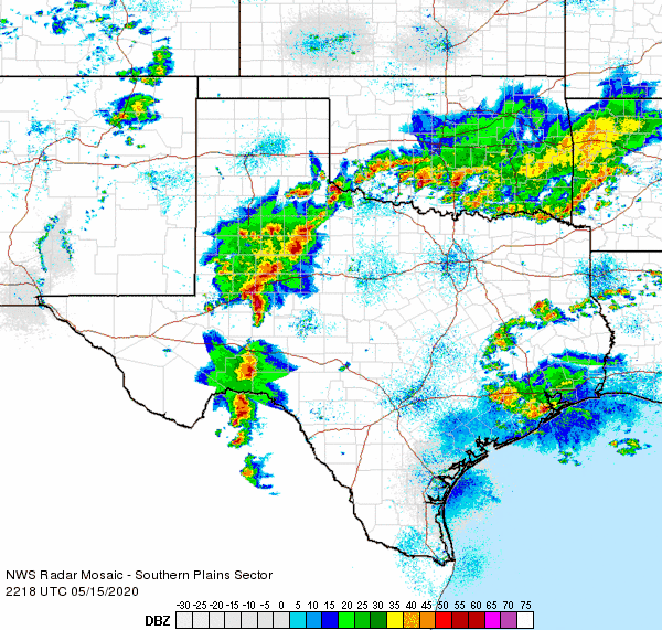
| After a day reprieve, thunderstorms erupted late Friday afternoon (15 May) along a dryline and weak cold front. Very strong instability allowed the developing storms to quickly become severe, producing hail and damaging winds. Wind gusts estimated at 60-70 mph accompanied torrential rain in Jayton. Many other locations experienced gusty winds, in excess of 50 mph, as cool outflow spread out from the growing area of rain and thunderstorms. | |||||||||||
 |
|||||||||||
| Regional radar animation valid from 3:08 pm to 4:18 pm on 15 May 2020. Additional regional radar animations can be found at: 3:28 pm to 4:38 pm and 5:18 pm to 6:28 pm. | |||||||||||
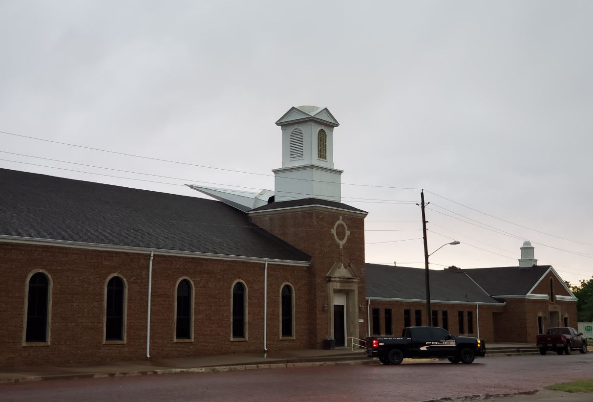
| Converging areas of thunderstorms, from the west and east, affected the southeast Texas Panhandle in the evening. This activity produced hail as large as ping pongs and hen eggs near Kirkland. In addition, powerful thunderstorm winds knocked the steeple off a church in Childress. The thunderstorms gradually weakened by mid-evening, leaving behind a large area of light to moderate rain and lingering gusty winds. | |||||||||||
 |
|||||||||||
| Steeple knocked off a church in Childress Friday evening (15 May 2020). The picture is courtesy of Kyle Davies via Steve Kersh. | |||||||||||
| The preliminary wind and storm reports for this active stretch of early to mid-May weather can be found below. | |||||||||||
PRELIMINARY LOCAL STORM REPORT...SUMMARY
NATIONAL WEATHER SERVICE LUBBOCK TX
554 AM CDT FRI MAY 08 2020

..TIME...   ...EVENT...      ...CITY LOCATION...     ...LAT.LON...
..DATE...   ....MAG....      ..COUNTY LOCATION..ST.. ...SOURCE....
            ..REMARKS..

0529 PM     HAIL             9 W LOCO                34.72N 100.31W
05/07/2020  E1.00 INCH       CHILDRESS          TX   PUBLIC

0534 PM     HAIL             4 N SMITHDALE           34.65N 100.19W
05/07/2020  E1.25 INCH       CHILDRESS          TX   TRAINED SPOTTER

0537 PM     HAIL             4 SSW LOCO              34.67N 100.19W
05/07/2020  E1.75 INCH       CHILDRESS          TX   TRAINED SPOTTER

0539 PM     HAIL             16 N CHILDRESS          34.66N 100.25W
05/07/2020  E1.50 INCH       CHILDRESS          TX   SOCIAL MEDIA

0542 PM     HAIL             4 SSW LOCO              34.67N 100.18W
05/07/2020  E2.50 INCH       CHILDRESS          TX   TRAINED SPOTTER

0544 PM     HAIL             4 SSW LOCO              34.66N 100.18W
05/07/2020  M3.25 INCH       CHILDRESS          TX   TRAINED SPOTTER

            MEASURED WITH MICROMETER

0549 PM     HAIL             3 SW LOCO               34.69N 100.19W
05/07/2020  M2.50 INCH       CHILDRESS          TX   SOCIAL MEDIA

1155 PM     NON-TSTM WND GST 2 NE DIMMITT            34.57N 102.29W
05/07/2020  M60 MPH          CASTRO             TX   MESONET

            MEASURED BY THE TTU WEST TX MESONET. SEVERE WIND GUSTS
            AT 1155 PM AND 1220 AM.

1208 AM     NON-TSTM WND GST HAPPY                   34.74N 101.84W
05/08/2020  M61 MPH          SWISHER            TX   MESONET

            MEASURED BY THE TTU WEST TX MESONET. SEVERE WIND GUSTS
            FROM 1208 THROUGH 1248.

1211 AM     NON-TSTM WND GST 9 WSW EARTH             34.19N 102.56W
05/08/2020  M62 MPH          LAMB               TX   MESONET

            MEASURED BY THE TTU WEST TX MESONET. SEVERE WIND GUSTS
            FROM 1202 THROUGH 0103.

1220 AM     NON-TSTM WND GST 2 ENE TULIA             34.54N 101.74W
05/08/2020  M63 MPH          SWISHER            TX   MESONET

            MEASURED BY THE TTU WEST TX MESONET. SEVERE WIND GUSTS
            FROM 1220 THROUGH 1255.

1220 AM     NON-TSTM WND GST VIGO PARK               34.65N 101.50W
05/08/2020  M58 MPH          SWISHER            TX   MESONET

            MEASURED BY THE TTU WEST TX MESONET.

1230 AM     NON-TSTM WND GST 2 S LESLEY              34.65N 100.81W
05/08/2020  M60 MPH          HALL               TX   MESONET

            MEASURED BY THE TTU WEST TX MESONET. SEVERE WIND GUSTS
            AT 1230 AND 0106.

1235 AM     NON-TSTM WND GST 1 NE AMHERST            34.02N 102.40W
05/08/2020  M59 MPH          LAMB               TX   MESONET

            MEASURED BY THE TTU WEST TX MESONET.

1235 AM     NON-TSTM WND GST 1 S PLAINVIEW           34.16N 101.72W
05/08/2020  M63 MPH          HALE               TX   AWOS

            SEVERE WIND GUSTS FROM 1235 THROUGH 0115.

1242 AM     NON-TSTM WND GST 3 WSW AIKEN             34.13N 101.57W
05/08/2020  M63 MPH          HALE               TX   MESONET

            MEASURED BY THE TTU WEST TX MESONET. SEVERE WIND GUSTS
            FROM 1242 THROUGH 0114.

1245 AM     NON-TSTM WND GST 7 ESE SILVERTON         34.45N 101.19W
05/08/2020  M63 MPH          BRISCOE            TX   MESONET

            MEASURED BY THE TTU WEST TX MESONET. SEVERE WIND GUSTS
            FROM 1245 THROUGH 1250.

1245 AM     NON-TSTM WND GST 5 ENE ABERNATHY         33.88N 101.76W
05/08/2020  M59 MPH          HALE               TX   MESONET

            MEASURED BY THE TTU WEST TX MESONET. SEVERE WIND GUSTS
            AT 1245 AND 0130.

0100 AM     NON-TSTM WND GST 1 S PLAINVIEW           34.18N 101.71W
05/08/2020  M62 MPH          HALE               TX   MESONET

            MEASURED BY THE TTU WEST TX MESONET.

0115 AM     NON-TSTM WND GST 6 S OLTON               34.09N 102.12W
05/08/2020  M64 MPH          LAMB               TX   MESONET

            MEASURED BY THE TTU WEST TX MESONET. SEVERE WIND GUSTS
            FROM 1245 THROUGH 0125.

0116 AM     NON-TSTM WND GST 6 NNE LUBBOCK           33.67N 101.82W
05/08/2020  M59 MPH          LUBBOCK            TX   ASOS

0136 AM     NON-TSTM WND GST REESE CENTER            33.61N 102.05W
05/08/2020  M60 MPH          LUBBOCK            TX   MESONET

            MEASURED BY THE TTU WEST TX MESONET. SEVERE WIND GUSTS
            FROM 0102 THROUGH 0136.

0143 AM     NON-TSTM WND GST 3 NNW MCADOO            33.77N 101.03W
05/08/2020  M59 MPH          DICKENS            TX   MESONET

            MEASURED BY THE TTU WEST TX MESONET. SEVERE WIND GUSTS
            AT 0143 THROUGH 0337.

0210 AM     NON-TSTM WND GST 6 NW WHITE RIVER LAKE   33.53N 101.17W
05/08/2020  M68 MPH          CROSBY             TX   MESONET

            MEASURED BY THE TTU WEST TX MESONET. SEVERE WIND GUSTS
            FROM 0200 THROUGH 0250.

