| Snow blankets the Rolling Plains and southwest Texas Panhandle 4-5 February 2020 |
|||||||||||
 |
|||||||||||
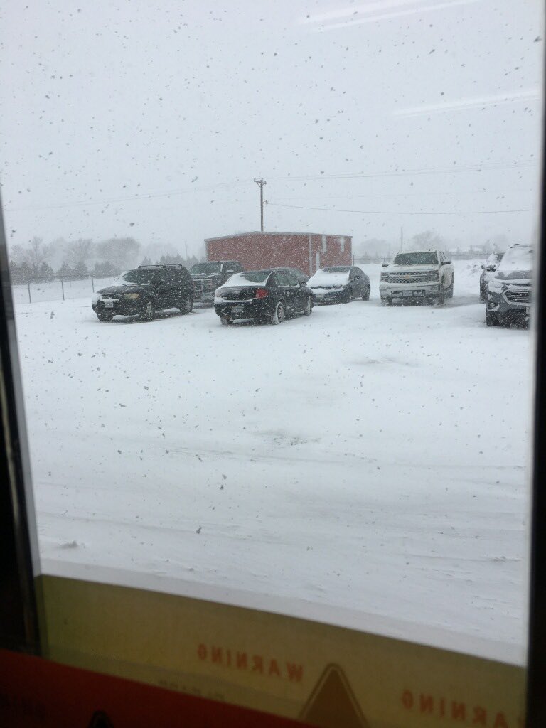
| Snowy scene in Friona on Tuesday afternoon (4 February 2020). The image is courtesy of KVII. | |||||||||||
|
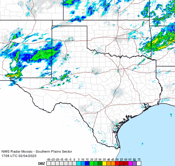
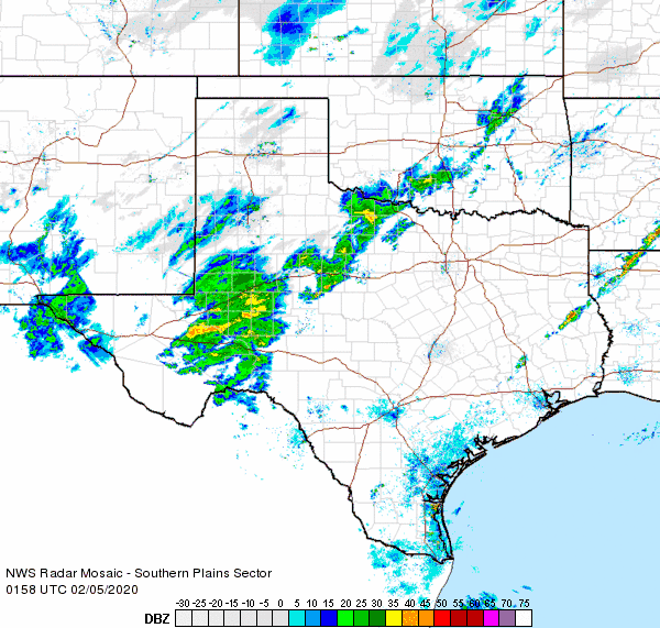
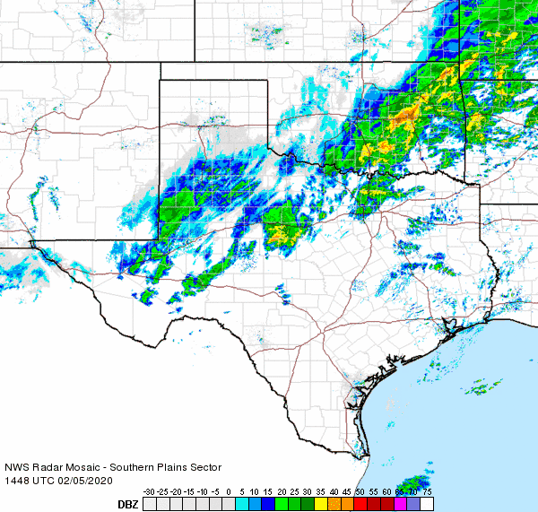
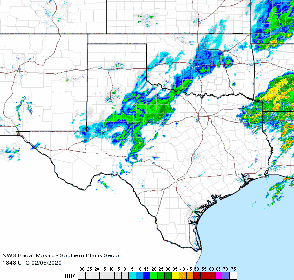
Monday, February 3rd, was a warm day, up in the 60s and 70s, but this quickly changed as a strong cold front moved through that evening. By the morning of the 4th, temperatures were below freezing across most of the South Plains region. To make matters even more interesting, a concentrated area of lift emerged from east-central New Mexico late in the morning and persisted across the southwest Texas Panhandle through much of the afternoon. |
|||||||||||
 |
|||||||||||
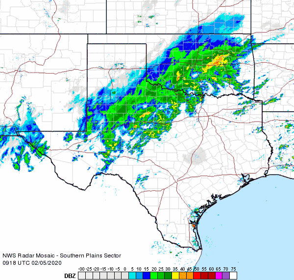
| Regional radar animation valid from 11:08 am to 12:18 pm on 4 February. | |||||||||||
| Moderate to heavy snow fell out of the concentrated band of precipitation from Friona through Dimmitt and Tulia. Snow totals of 3 to 5 inches were common by the time this snow band finally diminished late on the 4th. The heavy snow created tricky travel, though it did make for a pretty sight too. | |||||||||||
 |
 |
||||||||||
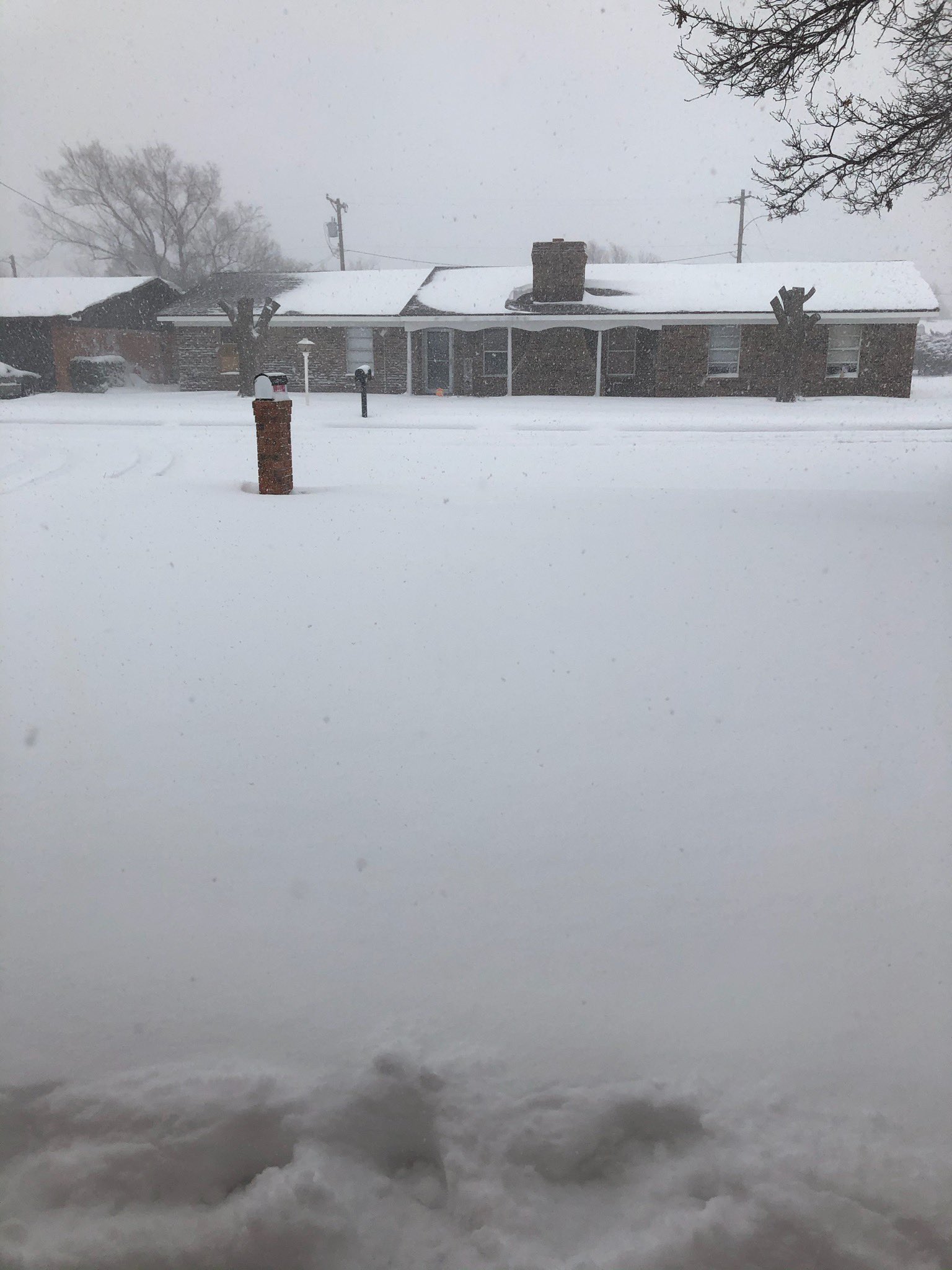
| Snow falling in Bovina (left) and Friona (right) Tuesday afternoon (4 February 2020). The pictures are courtesy of Steve Cobb. | |||||||||||
|
|||||||||||
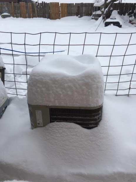
| This long-duration shield of snow was directed at the Rolling Plains, where snow persisted from Tuesday night through much of the day Wednesday before finally ending by evening. Most of the central and southern Rolling Plains tallied an impressive 6 to 12+ inches of snow, double to triple their average seasonal snow totals. | |||||||||||
 |
|||||||||||
| Close up view of a snowflake shortly after falling in Lubbock on 5 February 2020. The picture was taken by Jason Jordan. | |||||||||||
| All of the snow paralyzed travel, but it did result in rare wintry scenes all across the Rolling Plains, including in Jayton and Aspermont, as shown below. | |||||||||||
 |
 |
||||||||||
| Deep snow in Jayton (left) and near Lake Alan Henry (right) on February 5th and 6th, respectively. The pictures are courtesy of our COOP observers. | |||||||||||
|
Clearing skies, light winds and a fresh snow pack led to a bitterly cold night. Many spots with the deepest snow woke up to temperatures in the single digits Thursday morning. The West Texas Mesonet sites near Lomax, Colorado City and Seymour all bottom out below zero. Even where the snow was much lighter, like in Lubbock, lows still reached the lower teens. |
|||||||||||
 |
|||||||||||
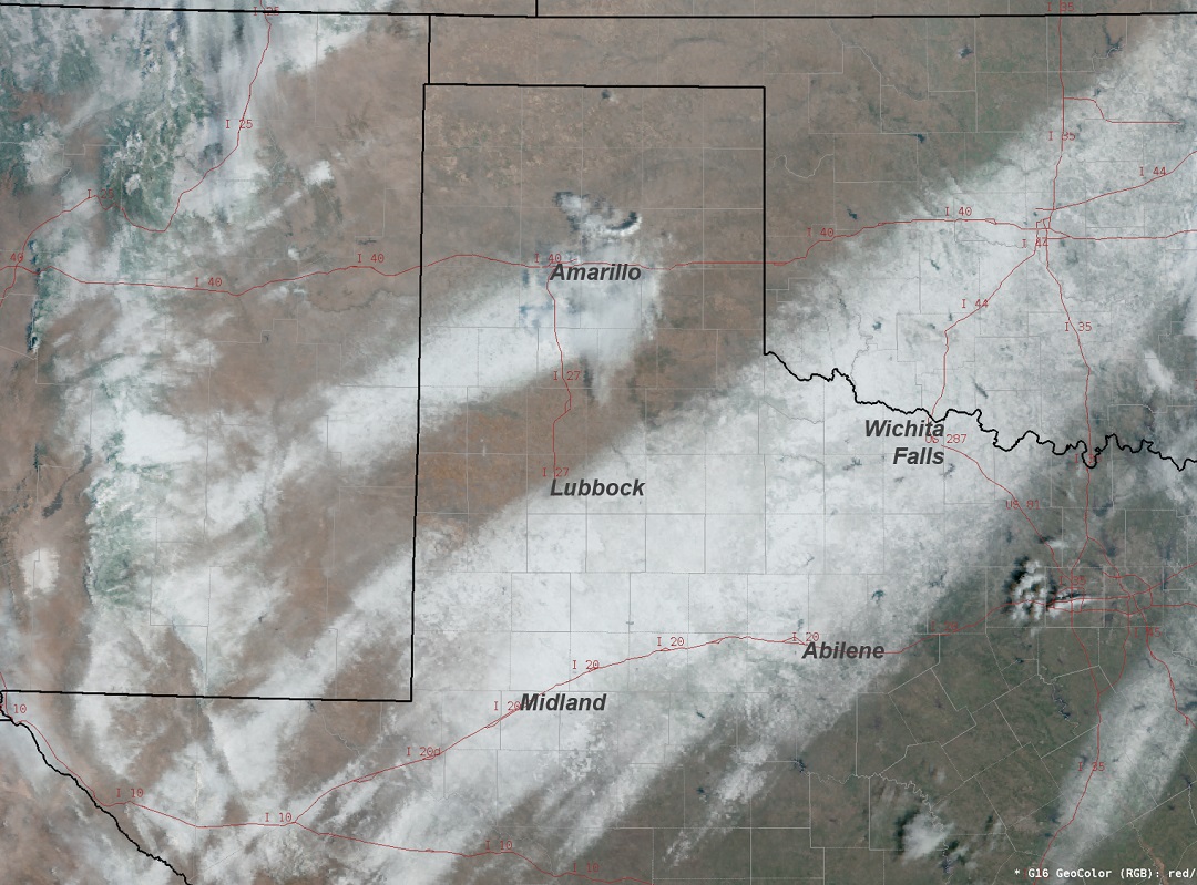
| Visible satellite image captured on 6 February 2020. | |||||||||||
| The mostly clear skies on the 6th also allowed for a beautiful visible satellite image (above), which clearly illustrates where the bands of heaviest snow fell the previous two days. A relatively narrow band is clearly apparent from east-central New Mexico into the south-central Texas Panhandle, which fell during the day of the 4th. The other larger area of snow spans from the northern Permian Basin into the southern South Plains, much of the Rolling Plains and off into western North Texas and central Oklahoma. | |||||||||||
 |
|||||||||||
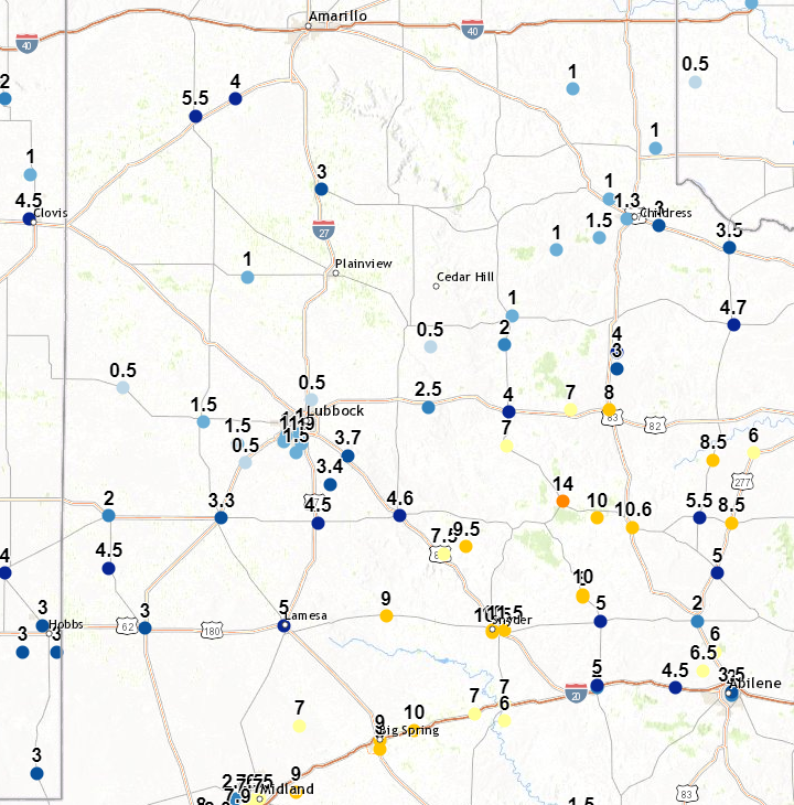
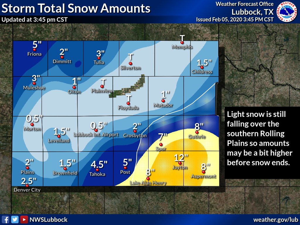
| Snow totals collected by the National Weather Service between February 4th and 6th. A contoured map displaying snow totals can be VIEWED HERE. | |||||||||||
|
The biggest snow winners stretched from around Big Spring through the southern Rolling Plains, where totals near and above 10 inches were common. Jayton was the overall winner, measuring a whopping 14 inches. On the other side of the spectrum, many locations between the two distinct bands of snow largely missed out from the west-central South Plains into the southeast Texas Panhandle. Lubbock was on the northern fringe of the heaviest band, with 3-4 inches falling on the southeast side of the county and only a dusting on the northwest side of the county. Officially, the Lubbock Airport record a half inch of snow, while southern parts of town generally saw 1-2 inches. A summary of the snow reports gathered from around the region can viewed below. |
|||||||||||
PRELIMINARY LOCAL STORM REPORT...SUMMARY
NATIONAL WEATHER SERVICE LUBBOCK TX
805 PM CST WED FEB 05 2020

..TIME...   ...EVENT...      ...CITY LOCATION...     ...LAT.LON...
..DATE...   ....MAG....      ..COUNTY LOCATION..ST.. ...SOURCE....
            ..REMARKS..

0630 PM     SNOW             FRIONA                  34.64N 102.72W
02/04/2020  M5.0 INCH        PARMER             TX   CO-OP OBSERVER

0635 PM     SNOW             MULESHOE                34.23N 102.73W
02/04/2020  M2.7 INCH        BAILEY             TX   CO-OP OBSERVER

0730 PM     SNOW             HART                    34.39N 102.11W
02/04/2020  M4.0 INCH        CASTRO             TX   CO-OP OBSERVER

0730 PM     SNOW             MULESHOE WILDLIFE REFUG 33.95N 102.75W
02/04/2020  M1.0 INCH        BAILEY             TX   CO-OP OBSERVER

1245 AM     SNOW             POST                    33.19N 101.38W
02/05/2020  E2.0 INCH        GARZA              TX   LAW ENFORCEMENT

            THE GARZA COUNTY SHERIFF`S OFFICE ESTIMATED AT LEAST 2
            INCHES SNOW DEPTH IN POST. ALSO, THEY REPORTED A VEHICLE
            SLID OFF THE ROAD NEAR JUSTICEBURG LAST EVENING.

0200 AM     SNOW             4 NNW WOODROW           33.49N 101.87W
02/05/2020  M1.0 INCH        LUBBOCK            TX   NWS EMPLOYEE

0327 AM     SNOW             TAHOKA                  33.16N 101.79W
02/05/2020  E4.0 INCH        LYNN               TX   LAW ENFORCEMENT

            SNOWING HARD

0338 AM     SNOW             SPUR                    33.48N 100.85W
02/05/2020  M3.5 INCH        DICKENS            TX   TX DOT

0341 AM     SNOW             DICKENS                 33.62N 100.84W
02/05/2020  E4.0 INCH        DICKENS            TX   LAW ENFORCEMENT

0343 AM     SNOW             PEACOCK                 33.18N 100.40W
02/05/2020  M10.0 INCH       STONEWALL          TX   LAW ENFORCEMENT

0349 AM     SNOW             ASPERMONT               33.14N 100.22W
02/05/2020  M8.0 INCH        STONEWALL          TX   LAW ENFORCEMENT

0354 AM     SNOW             JAYTON                  33.25N 100.57W
02/05/2020  M6.0 INCH        KENT               TX   LAW ENFORCEMENT

            STILL SNOWING

0550 AM     SNOW             CROSBYTON               33.64N 101.24W
02/05/2020  M3.0 INCH        CROSBY             TX   LAW ENFORCEMENT

            DRIFTS OF 5-6"

0600 AM     SNOW             4 SSW LUBBOCK           33.53N 101.88W
02/05/2020  M0.5 INCH        LUBBOCK            TX   NWS OFFICE

0641 AM     SNOW             DENVER CITY             32.97N 102.83W
02/05/2020  E2.0 INCH        YOAKUM             TX   LAW ENFORCEMENT

0647 AM     SNOW             JAYTON                  33.25N 100.57W
02/05/2020  M7.0 INCH        KENT               TX   LAW ENFORCEMENT

            STILL SNOWING

0709 AM     SNOW             POST                    33.19N 101.38W
02/05/2020  M4.5 INCH        GARZA              TX   CO-OP OBSERVER

0711 AM     SNOW             TAHOKA                  33.16N 101.79W
02/05/2020  M4.5 INCH        LYNN               TX   CO-OP OBSERVER

0721 AM     SNOW             1 WSW GUTHRIE           33.63N 100.34W
02/05/2020  M8.0 INCH        KING               TX   CO-OP OBSERVER

            6666 RANCH

0731 AM     SNOW             ASPERMONT               33.14N 100.22W
02/05/2020  M8.1 INCH        STONEWALL          TX   CO-OP OBSERVER

            THUNDERSNOW OCCURRED

0734 AM     SNOW             LEVELLAND               33.58N 102.36W
02/05/2020  M1.5 INCH        HOCKLEY            TX   CO-OP OBSERVER

0743 AM     SNOW             15 S PADUCAH            33.80N 100.30W
02/05/2020  M3.0 INCH        KING               TX   CO-OP OBSERVER

0745 AM     SNOW             3 W WOODROW             33.45N 101.90W
02/05/2020  M0.5 INCH        LUBBOCK            TX   NWS EMPLOYEE

0754 AM     SNOW             ROPESVILLE              33.41N 102.15W
02/05/2020  M0.5 INCH        HOCKLEY            TX   CO-OP OBSERVER

            ICE PELLETS MIXED IN

0800 AM     SNOW             LAKE ALAN HENRY         33.06N 101.05W
02/05/2020  M8.0 INCH        GARZA              TX   CO-OP OBSERVER

0800 AM     SNOW             MORTON                  33.72N 102.76W
02/05/2020  M0.5 INCH        COCHRAN            TX   CO-OP OBSERVER

0800 AM     SNOW             OLTON                   34.18N 102.14W
02/05/2020  M1.0 INCH        LAMB               TX   CO-OP OBSERVER

0800 AM     SNOW             7 SW LUBBOCK            33.50N 101.96W
02/05/2020  M0.5 INCH        LUBBOCK            TX   NWS EMPLOYEE

0815 AM     SNOW             TULIA                   34.54N 101.77W
02/05/2020  M3.0 INCH        SWISHER            TX   CO-OP OBSERVER

0815 AM     SNOW             NORTHFIELD              34.29N 100.60W
02/05/2020  M1.0 INCH        MOTLEY             TX   CO-OP OBSERVER

0819 AM     SNOW             1 W KIRKLAND            34.39N 100.09W
02/05/2020  M3.0 INCH        CHILDRESS          TX   CO-OP OBSERVER

0820 AM     SNOW             5 SW LUBBOCK            33.52N 101.95W
02/05/2020  M0.5 INCH        LUBBOCK            TX   NWS EMPLOYEE

0822 AM     SNOW             BROWNFIELD              33.18N 102.27W
02/05/2020  M1.5 INCH        TERRY              TX   CO-OP OBSERVER

0822 AM     SNOW             7 NW CHILDRESS          34.50N 100.34W
02/05/2020  M1.0 INCH        CHILDRESS          TX   CO-OP OBSERVER

0823 AM     SNOW             ROARING SPRINGS         33.90N 100.86W
02/05/2020  M2.0 INCH        MOTLEY             TX   CO-OP OBSERVER

0830 AM     SNOW             PLAINS                  33.19N 102.83W
02/05/2020  M2.0 INCH        YOAKUM             TX   CO-OP OBSERVER

0830 AM     SNOW             3 S TELL                34.34N 100.39W
02/05/2020  M1.5 INCH        CHILDRESS          TX   CO-OP OBSERVER

0833 AM     SNOW             DENVER CITY             32.97N 102.83W
02/05/2020  M2.5 INCH        YOAKUM             TX   CO-OP OBSERVER

0845 AM     SNOW             SPUR                    33.48N 100.85W
02/05/2020  M7.0 INCH        DICKENS            TX   CO-OP OBSERVER

0847 AM     SNOW             CHILDRESS               34.42N 100.25W
02/05/2020  M1.2 INCH        CHILDRESS          TX   CO-OP OBSERVER

            CHILDRESS USDA

0849 AM     SNOW             9 SE FLOYDADA           33.89N 101.23W
02/05/2020  M0.5 INCH        FLOYD              TX   CO-OP OBSERVER

0852 AM     SNOW             MATADOR                 34.02N 100.82W
02/05/2020  M1.0 INCH        MOTLEY             TX   CO-OP OBSERVER

0854 AM     SNOW             3 ESE JUSTICEBURG       33.03N 101.16W
02/05/2020  M7.5 INCH        GARZA              TX   SOCIAL MEDIA

0938 AM     SNOW             10 S PADUCAH            33.87N 100.30W
02/05/2020  M4.0 INCH        COTTLE             TX   CO-OP OBSERVER

1047 AM     SNOW             JAYTON                  33.25N 100.57W
02/05/2020  M9.0 INCH        KENT               TX   LAW ENFORCEMENT

1130 AM     SNOW             4 SSW LUBBOCK           33.53N 101.88W
02/05/2020  M1.0 INCH        LUBBOCK            TX   NWS OFFICE

1150 AM     SNOW             6 NNE LUBBOCK           33.67N 101.82W
02/05/2020  M0.5 INCH        LUBBOCK            TX   WX OBSERVER FAA

1200 PM     SNOW             SLATON                  33.44N 101.64W
02/05/2020  M3.7 INCH        LUBBOCK            TX   SOCIAL MEDIA

1224 PM     SNOW             WILSON                  33.32N 101.73W
02/05/2020  M3.4 INCH        LYNN               TX   SOCIAL MEDIA

1250 PM     SNOW             4 NNW WOODROW           33.50N 101.87W
02/05/2020  M1.9 INCH        LUBBOCK            TX   NWS EMPLOYEE

0120 PM     SNOW             CHILDRESS               34.42N 100.25W
02/05/2020  M1.3 INCH        CHILDRESS          TX   CO-OP OBSERVER

0157 PM     SNOW             JAYTON                  33.25N 100.57W
02/05/2020  M12.0 INCH       KENT               TX   CO-OP OBSERVER

0440 PM     SNOW             JAYTON                  33.25N 100.57W
02/05/2020  M14.0 INCH       KENT               TX   CO-OP OBSERVER

1018 AM     SNOW             SOUTHLAND               33.36N 101.55W
02/06/2020  E3.0 INCH        GARZA              TX   LAW ENFORCEMENT

1100 AM     SNOW             WHITE RIVER LAKE        33.48N 101.10W
02/05/2020  M4.5 INCH        CROSBY             TX   CO-OP OBSERVER

1100 AM     SNOW             SPUR                    33.48N 100.85W
02/05/2020  M7.5 INCH        DICKENS            TX   CO-OP OBSERVER

0946 AM     SNOW             PLAINS                  33.19N 102.83W
02/05/2020  M2.5 INCH        YOAKUM             TX   CO-OP OBSERVER

1030 AM     SNOW             4 SSW LUBBOCK           33.53N 101.88W
02/05/2020  M1.2 INCH        LUBBOCK            TX   NWS OFFICE

1030 AM     SNOW             5 SW LUBBOCK            33.52N 101.95W
02/05/2020  M1.0 INCH        LUBBOCK            TX   NWS EMPLOYEE

1030 AM     SNOW             7 SW LUBBOCK            33.50N 101.96W
02/05/2020  M1.0 INCH        LUBBOCK            TX   NWS EMPLOYEE

0936 AM     SNOW             LAKE ALAN HENRY         33.06N 101.05W
02/05/2020  M9.5 INCH        GARZA              TX   CO-OP OBSERVER

0500 AM     SNOW             21 NNE CHILDRESS        34.71N 100.11W
02/05/2020  M1.0 INCH        CHILDRESS          TX   CO-OP OBSERVER

0912 AM     SNOW             DENVER CITY             32.97N 102.83W
02/05/2020  M4.5 INCH        YOAKUM             TX   CO-OP OBSERVER

1000 AM     SNOW             3 W WOODROW             33.45N 101.90W
02/05/2020  M1.5 INCH        LUBBOCK            TX   NWS EMPLOYEE

0700 PM     SNOW             VIGO PARK               34.65N 101.50W
02/04/2020  M3.0 INCH        SWISHER            TX   CO-OP OBSERVER

0820 AM     SNOW             6 NNW ROPESVILLE        33.49N 102.19W
02/05/2020  M1.5 INCH        HOCKLEY            TX   CO-OP OBSERVER

0900 AM     SNOW             TAHOKA                  33.16N 101.79W
02/05/2020  M4.5 INCH        LYNN               TX   CO-OP OBSERVER

0814 AM     SNOW             12 W GUTHRIE            33.63N 100.53W
02/05/2020  M7.0 INCH        DICKENS            TX   CO-OP OBSERVER

            PITCHFORK RANCH

1000 AM     SNOW             POST                    33.19N 101.38W
02/05/2020  M4.6 INCH        GARZA              TX   CO-OP OBSERVER

1030 AM     SNOW             CROSBYTON               33.64N 101.24W
02/05/2020  M2.5 INCH        CROSBY             TX   CO-OP OBSERVER

0900 AM     SNOW             BROWNFIELD              33.18N 102.27W
02/05/2020  M3.3 INCH        TERRY              TX   CO-OP OBSERVER

0900 AM     SNOW             ASPERMONT               33.14N 100.22W
02/05/2020  M10.6 INCH       STONEWALL          TX   CO-OP OBSERVER

