| Snow and rain fall on the southeast Texas Panhandle 28 January 2020 |
|||||||||||
 |
|||||||||||
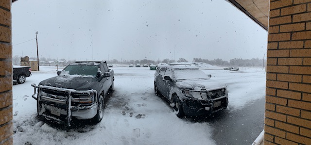
| Snowy scene in Memphis on Tuesday morning (28 January 2020). The image is courtesy of Memphis Sheriff's Office. | |||||||||||
|
A potent upper level low emerging across the southern High Plains supplied an abrupt change in the weather on Tuesday, January 28th. After basking under mostly sunny skies and temperatures in the 60s and 70s the previous day, the storm system brought a sharp cold front early Tuesday morning, which was accompanied by areas of rain and snow in spots and gusty northerly winds for all. |
|||||||||||
 |
|||||||||||
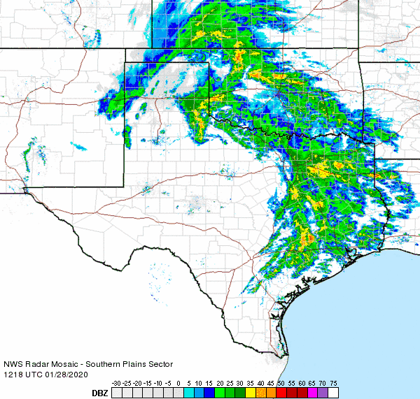
| Regional radar animation valid from 6:18 am to 7:28 am on 28 January 2020. Additional regional radar animations can be viewed at: 8:58 am to 10:08 am on 28 January 2020; and 12:48 pm to 1:58 pm on 28 January 2020. | |||||||||||
| The precipitation blossomed near and north of the track of the center of the low pressure system early Tuesday. The bulk of the precipitation affected the Panhandles into southern Kansas and much of Oklahoma, with spotty lighter rain found over parts of the South Plains and southern Rolling Plains. One heavier band of precipitation developed across the southeast Texas Panhandle into the northern Rolling Plains Tuesday morning. This band lingered for several hours before finally weakening and shifting eastward in the afternoon. | |||||||||||
 |
|||||||||||
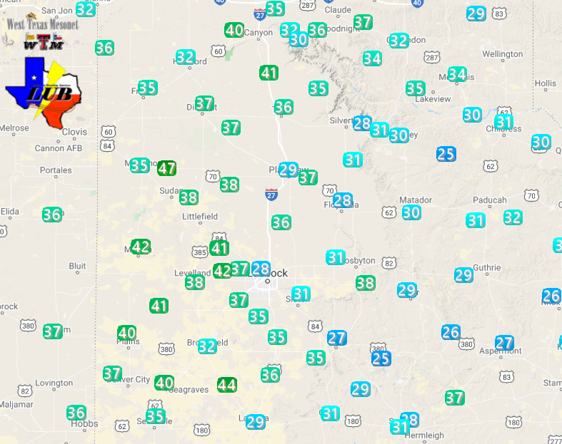
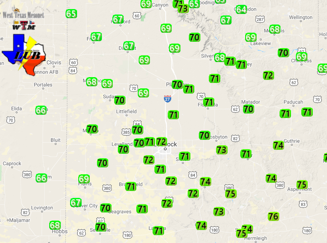
| Observed temperatures around 8:15 am on Tuesday (28 January 2020). The data are courtesy of the West Texas Mesonet. The observed high temperatures from the previous day (27 January) can be VIEWED HERE. | |||||||||||
|
|||||||||||
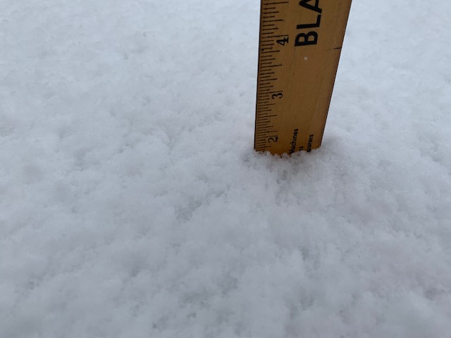
| Even where the snow fell, temperatures never dropped below freezing, but the moderate to heavy snow did accumulate on roadways making them slushy and slippery for a period. The slick conditions did contribute to a few vehicles skidding off into the ditch along Highway 287 Tuesday morning. Once the snow stopped, temperatures rebounded into the upper 30s, allowing roadways to quickly improve. | |||||||||||
 |
|||||||||||
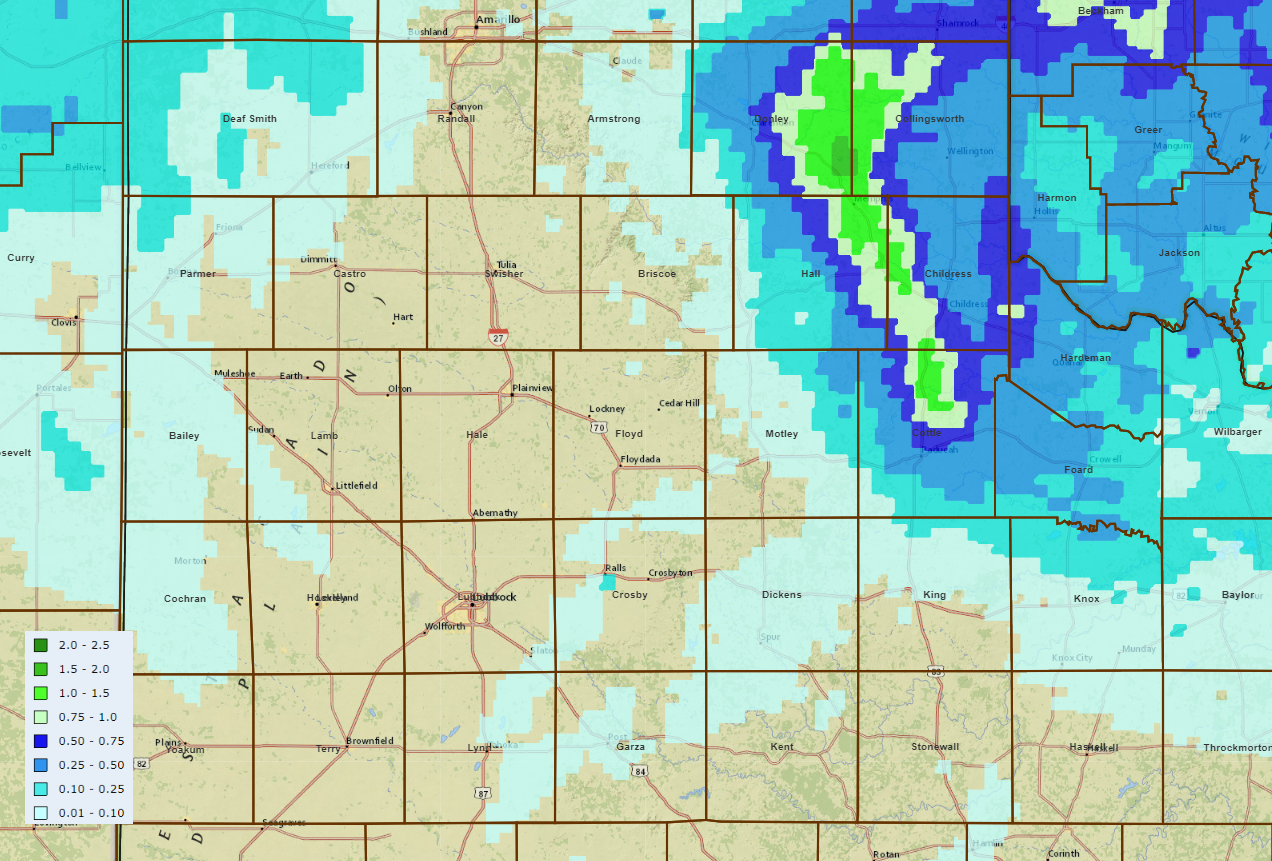
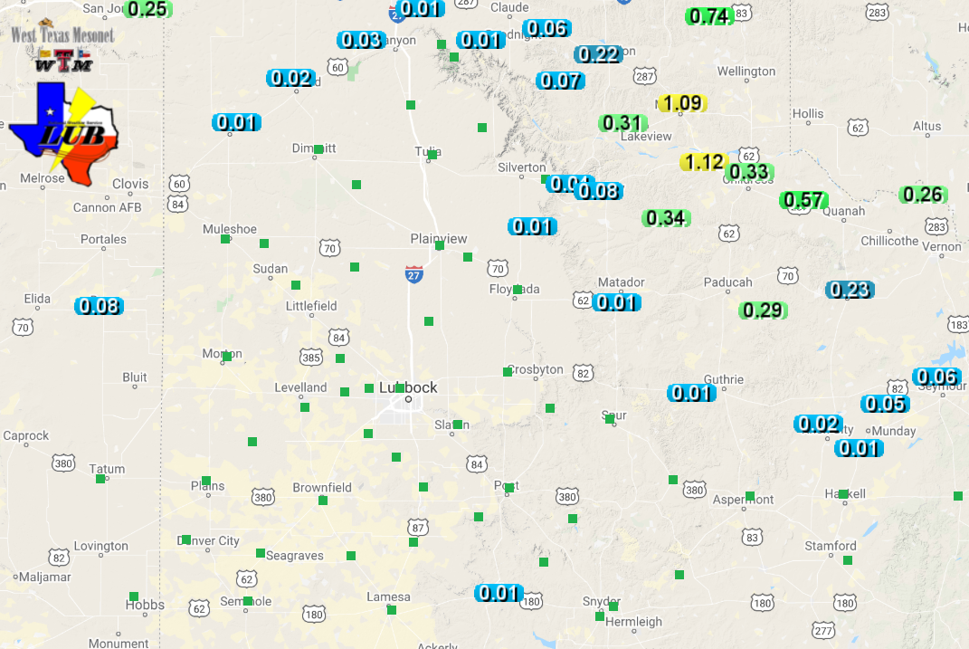
| Radar-estimated and bias-correct liquid equivalent (inches) from the rain and snow on 28 January 2020. A plot of West Texas Mesonet rain and melted snow totals can be FOUND HERE. | |||||||||||
| Combined, the rain and snow melted to in excess of an inch over a narrow swath from near Memphis to west of Childress to north of Paducah. Officially, the Childress airport measured 0.77" of liquid, most of which fell as rain. Childress did report light to moderate snow late Tuesday morning into early afternoon, though a thin layer of snow only briefly covered the grassy surfaces before quickly melting. | |||||||||||
 |
|||||||||||
| Maximum wind speeds observed by the West Texas Mesonet on 28 January 2019. The peak wind gusts for the day can be VIEWED HERE. | |||||||||||
|
Although the significant rain (and snow) largely missed the South Plains and southern Rolling Plains, no one escaped the gusty northerly winds. In fact, the winds were maximized on the Caprock during the day Tuesday. Sustained wind speeds of 30 to 40 mph were common, with peak gusts of 45 to 55 mph. The winds gradually diminished late Tuesday afternoon into Tuesday evening. Below are the 24-hour highs, lows and precipitation, as reported by the Lubbock COOP Observers from around the region on Tuesday morning and Wednesday morning (28 and 29 January 2020). |
Daily Temperature and Precipitation Summary
National Weather Service Lubbock TX
1209 PM CST Tue Jan 28 2020

 The following data are for the previous 24 HRS (8AM - 8AM)
 Highs typically from the previous day.  Low can be either day.

                                                        7-8AM
                      24 HOUR  TODAY   24HR       SNOW  SNOW
  LOCATION            HI  LOW  7-8AM   PCPN       FALL  DEPTH
 Aspermont            75   32   45      0
 Big Spring AWOS      74   36   42      0
 Brownfield           70   31   37      0
 Childress            69   38   40     0.46
 Childress ASOS       70   38   37     0.59
 Crosbyton            70   35   36      0
 Denver City          67   37   37      0
 Dimmitt               M    M    M       M
 Floydada             69   34   34       T
 Friona               66   32   32     0.03          T      T
 Guthrie              74   33   43      0
 Hart                 68   29   32      0
 Jayton                M    M    M      0
 Lake Alan Henry      74   36   43      0
 Levelland            69   32   36      0
 Littlefield 5SE      70   28   34      0
 Lubbock              72   33   37      0
 Matador              71   36   36     0.06
 Memphis              67   34   34     0.80
 Morton               69   31   34       T
 Muleshoe             68   27   33      0
 Muleshoe Refuge      67   25   35     0.01
 Olton                70   33   33      0
 Paducah 15S (Grow)   69   36   39     0.20
 Plainview Wtr Plnt   70   32   34      0
 Plainview Dly Hrld   70   33   34      0
 Plains               66   28   35      0
 Post                 72   37   39      0
 Silverton            69   24   33      0
 Snyder               74   40   43      0
 Spur                 71   34   38      0
 Tahoka               73   37   38      0
 Tulia                70   31   33      0
 Turkey               71   34   35     0.15
 White River Lake     73   35   40      0

  Automated Stations                   High Low  7AM    Rain
 Muleshoe Wildlife Refuge                68  24   35     0
 Caprock Canyons State Park RAWS         72  35   36    0.05
 Jayton RAWS                             74  34   47     0

 The following mesonet data show 24hr highs and lows
 and precipitation 8am-8am.

 Texas Tech West Texas Mesonet...
                      24-HR   8AM   8AM-8AM
                      HI LOW
 Abernathy 5NE        71  33   35      0
 Aiken 3WSW           71  29   34      0
 Adrian 6WSW          60  30   32      0
 Amarillo 7SSE        68  28   31      0
 Amarillo 9NNE        66  30   32      0
 Amarillo 15NNW       64  32   33      0
 Amherst 1NE          70  31   34      0
 Andrews 2NE          72  39   41      0
 Anton 6S             70  27   35      0
 Aspermont 3NE        75  31   45      0
 BBNP Persimmon Gap   78  41   51      0
 BBNP Castolon 1NW    81  42   53      0
 Big Lake 1WNW        76  42   46     0.02
 Bootleg 11WNW        65  30   32     0.01
 Boys Ranch 1WSW      63  23   35     0.01
 Brownfield 2S        71  32   37      0
 Canadian 6E          65  31   31     0.08
 Caprock Canyons      71  35   35     0.04
 Childress 2NNE       69  36   36     0.23
 Clarendon 2WSW       64  32   32     0.15
 Claude 12SW          65  31   31      0
 Clyde  2WNW          75  44   46      0
 Colorado City 5NW    77  36   45      0
 Coyanosa             75  43   50      0
 Crane 1NNW           75  40   42     0.01
 Crowell 1E           71  39   48     0.04
 Dell City 1N         67  30   41     0.01
 Denver City 7W       67  29   37      0
 Dimmitt 2NE          67  30   31      0
 Dora NM 2SW          66  32   35     0.08
 Dozier 2W            66  33   33     0.26
 Earth 9WSW           69  28   33      0
 Endee NM 2SW         63  25   34     0.08
 Estelline 3SSE       70  35   37     0.73
 Floydada 2NE         71  35   35      0
 Fluvanna 3W          73  40   40      0
 Fort Chadborne       78  38   47      0
 Fort Lancaster       79  34   51     0.09
 Fort Lewis CO        37   1    2     0.20
 Fort McKavett        77  38   44     0.19
 Friona 2NE           67  30   31      0
 Fritch 1WNW          63  32   33     0.01
 Gail 2SE             74  37   40      0
 Goodlett 3W          69  36   38     0.21
 Goodnight            63  32   32     0.05
 Graham 5SW           72  37   37      0
 Guadalupe N.P.       58  37   38     0.11
 Guthrie 10W          74  38   41     0.01
 Hackberry 2SSE       71  38   41     0.25
 Happy 1E             69  32   32      0
 Hart 3N              69  31   32      0
 Haskell 1NW          72  43   44      0
 Hefner 1SW           72  40   49      0
 Hereford 2NW         67  29   31      0
 Hobbs NM 5NW         68  36   40      0
 Jayton 1S            74  33   45      0
 Junction 1SSW        78  31   46     0.49
 Kent 9E              68  43   46     0.01
 Knox City 3NW        72  36   51      0
 Lake Alan Henry 1NW  75  34   42      0
 Lake McClellan 2NW   63  31   31     0.03
 Lamesa 2SE           71  37   39      0
 Lesley 2S            69  33   36     0.24
 Levelland 4S         70  30   36      0
 Lomax 1SSE           75  36   42      0
 Lubbock (TX Tech)    72  29   36      0
 Lubbock (Reese Ctr)  71  30   36      0
 McLean 1E            62  30   30     0.11
 Memphis 1NE          68  34   35     0.69
 Menard 2NWE          78  33   44     0.25
 Mertzon 3NNE         80  33   49      0
 Morton 1NE           70  30   36      0
 Muleshoe 2S          68  29   34      0
 New Home             71  33   38      0
 Northfield 1S        72  37   37     0.33
 O'Donnell 1N         72  37   38      0
 Olton 6S             69  31   33      0
 Odell 4ENE           69  32   49     0.05
 Paducah 10SW         71  38   39     0.14
 Paloduro 4E JA Ranch 67  29   34     0.06
 Palo Duro Canyon Rim 71  31   31      0
 Palo Duro Cnyn Floor 73  28   35      0
 Palo Duro Reservoir  64  28   31     0.26
 Pampa 2E             62  30   30     0.02
 Panhandle 1SSW       65  30   30     0.02
 Plains 3N            69  27   36      0
 Plainview 1S         70  32   34      0
 Post 1NE             74  37   39      0
 Ralls 1SE            70  35   36      0
 Roaring Springs 3N   70  35   35     0.01
 Rotan 5W             76  39   44      0
 San Angelo 7NW        M   M    M        M
 Seagraves 1SW        70  27   38      0
 Segovia 7SSW         76  48   50     0.48
 Seminole 2N          70  35   39      0
 Seymour 3NW          71  41   49      0
 Sierra Blanca 1SSE   64  38   41     0.01
 Silverton 7E         68  33   33      0
 Slaton 2NE           71  35   37      0
 Smyer                70  31   36      0
 Snyder 3E            74  40   41      0
 Snyder 3SSW (WTC)    75  40   42      0
 South Plains 3ENE    71  34   34     0.01
 Spur 1W              71  33   39      0
 Stamford 5ESE        72  41   44      0
 Stinnett 1NNW        63  30   31     0.01
 St Lawrence 5SW      74  39   45     0.01
 Sterling City 4WNW   76  33   47     0.03
 Sundown 8SW          70  28   36      0
 Sweetwater 11SW      75  42   42     0.01
 Tahoka 3NE           72  36   37      0
 Tarzan 2WNW          73  34   41      0
 Tatum NM 2SW         66  30   39      0
 Throckmorton 1SW     73  40   50      0
 Truscott 2SE         71  38   48     0.05
 Tulia 2NE            69  32   33      0
 Turkey 2WSW          71  36   36     0.07
 Umbarger 3NNE        69  30   31      0
 Van Horn 3ENE        68  41   44      0
 Vigo Park            70  31   32      0
 Wall 1E              79  36   45     0.24
 Weinert 2NNE         73  43   51      0
 Welch                71  34   39      0
 White River Lk 6NW   73  37   37      0
 Wolfforth 6SW        72  28   37      0

Supplemental Precipitation..
 Childress USDA (Childress Cnty)     0.32
 Childress 14NW (Childress Cnty)        M
 Childress 7NW  (Childress Cnty)     0.44
 Dodson 5S      (Childress Cnty)        M
 Kirkland 1W    (Childress Cnty)     0.40
 Dumont         (NW King County)        M
 Floydada 9SE     (Floyd County)     0.02
 Flomot 2E    (NW Motley County)     0.02
 Flomot 4NE   (NW Motley County)     0.07
 Lubbock 9N     (Lubbock County)      0
 Lubbock 7WSW (77TH NR Iola)          0
 Lubbock 7SW  (90TH NR Slide)         0
 Lubbock 7SW #2 (103RD NR Slide)      0
 Northfield   (NE Motley County)     0.34
 Paducah 10S     (Cottle County)     0.10
 Pitchfork Ranch     (E Dickens)      0
 Reese 4E   (8th ST & Milwaukee)      0
 Roaring Springs (Motley County)     0.01
 Ropesville 6NNW(Hockley County)      0
 Shallowater    (Lubbock County)       T
 Tell 3S        (Childress Cnty)     0.62
 Woodrow 3W  (154th & Indiana)        0

  ..Automated USGS Rain Gauges..
 Aspermont 13N (Stonewall County)     0
 Brice 6SW        (Hall County)      0.03
 Childress 10N(Childress County)     1.13
 Friona 12S  Running Water Dr         0
 Justiceburg(Garza County)            0
 Kirkland 1NNE N Grosebeck Ck        0.21
 Lake Alan Henry (Garza County)       0
 Lockney 10SW  Callahan Draw          0
 Lubbock 4ESE (50TH LOOP 289)         0
 Mackenzie Lake (Briscoe County)      0
 Silverton 7W Rock Ck Tr              0
 Wellman 1NE (Terry County)           0
 White River Lake (Crosby County)     0
 Wayside (Armstrong County)           0

 ------------- Agricultural Data -----------------
                                      Pan Evaporation
 Lake Alan Henry                               0.25

