| The first snow of 2020 for the South Plains 10-11 January 2020 |
|
 |
|
| Snowy start to the day in Pep, Texas, on 11 January 2020. The image is courtesy of Stacy Schroeder. | |
|
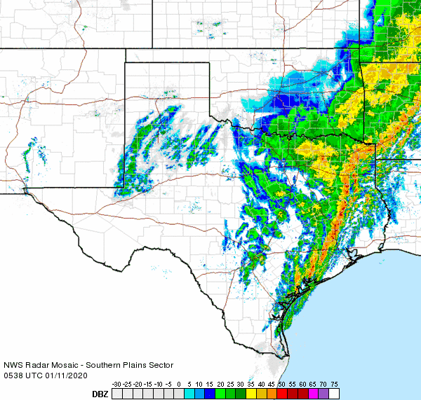
After a mild January day (Friday, 10 January 2020), with highs primarily in the 60s, a strong cold front moved through the South Plains region late in the day. In addition to providing gusty northerly winds, the front carried much colder air southward. The front, coupled with a passing upper level disturbance, were sufficient to cause several bands of precipitation to develop across the southwest Texas Panhandle and western South Plains Friday evening. The precipitation quickly changed from rain to snow as the cold air infiltrated the region. |
|
 |
|
| Regional radar animation valid from 12:58 am to 2:08 am on 11 January 2020. Additional animations can be found at: 11:38 pm on 10 January to 12:48 am on 11 January 2020; and 2:48 am to 3:58 am on 11 January 2020. | |
| The bands of snow then pivoted southeastward across much of the South Plains late Friday night and early Saturday morning before diminishing and shifting east of the area. The light to moderate snow didn't last very long at any given location, but many spots across the Caprock did pick up a quick dusting to an inch of snow. | |
 |
 |
| View of the snow in Lubbock (left) and Friona (right) late Friday night into Saturday morning (10-11 January 2020). | |
| The snowfall did make for a pretty sight, and early on it didn't cause many problems on area roadways as the ground was relatively "warm". This allowed most of the snow to melt on roadways initially. However, as temperatures continued to fall in the 20s (and even teens in spots), the residual moisture then froze. This caused roadways to become very slick, which contributed to many accidents. Sadly, one accident that occurred on I-27 on the north side of Lubbock took the lives of two first responders (a police officer and a firefighter), and critically injured another, while they were assisting with two earlier accidents. | |
 |
|
| Radar-estimated and bias-correct liquid equivalent from the rain and snow 10-11 January 2020. The melted totals from the West Texas Mesonet for this same period can be VIEWED HERE. | |
| Overall, precipitation totals were on the light side. Snow totals of a dusting to around an inch were common, with a few locations, including in parts of Lubbock, seeing a little over an inch. One report of 3 inches of snow was received from Bovina, in Parmer County. Once the snow was melted down, liquid equivalents ranged from a trace to about a tenth of an inch. Officially, Lubbock recorded exactly 1 inch of snow, which melted down to 0.04 inches of liquid. | |
 |
|
| Visible satellite image captured at 9:06 am on 11 January 2020. | |
| The above satellite image snapped after the sun rose Saturday morning nicely illustrates the coverage of the snow. Below can be found numerous snow observations collected from around the region. | |
Click on the headings below to view the following Text Products:
Daily Temperature and Precipitation Summary
National Weather Service Lubbock TX
925 AM CST Sat Jan 11 2020

 The following data are for the previous 24 HRS (8AM - 8AM)
 Highs typically from the previous day.  Low can be either day.

                                                        7-8AM
                      24 HOUR  TODAY   24HR       SNOW  SNOW
  LOCATION            HI  LOW  7-8AM   PCPN       FALL  DEPTH
 Aspermont            69   31   31     0.01
 Big Spring AWOS      67   32   30       0
 Brownfield           61   21   21     0.10        1.0      1
 Childress             M    M    M        M          M      M
 Childress ASOS       66   24   22       T           T      0
 Crosbyton            63   20   21     0.01          T      T
 Denver City           M    M    M        M          M      M
 Dimmitt              56   17   17        M          T      0
 Floydada             62   20   21       T           T      0
 Friona               50   13   13     0.14        1.0      1
 Guthrie              68   28   28       0
 Hart                 58   17   17       T
 Jayton                M    M    M        M          M      M
 Lake Alan Henry       M    M    M        M          M      M
 Levelland            62   16   16     0.02        1.1      1
 Littlefield 5SE      60   20   21        M        0.1      T
 Lubbock              64   20   20     0.04        1.0      1
 Matador              66   23   23        M
 Memphis               M    M    M       0
 Morton               61   18   18     0.05        0.5      T
 Muleshoe             60   18   18     0.08          T      T
 Muleshoe Refuge      59   14   15        M          M      M
 Olton                58   20   21       T         0.1      0
 Paducah 15S (Grow)   66   26   26       0
 Plainview Wtr Plnt   58   18   18     0.02        0.2      T
 Plainview Dly Hrld    M    M    M        M          M      M
 Plains               59   20   21        M          T      T
 Post                 65   28   28       T           T      T
 Silverton            61   16   17        M        1.0      1
 Snyder               68   31   33     0.01          M      M
 Spur                 69   26   26        M
 Tahoka               66   26   26     0.02          T      T
 Tulia                53   15   16       0
 Turkey               61   23   24       T           T      T
 White River Lake      M    M    M        M          M      M

  Automated Stations                   High Low  7AM    Rain
 Muleshoe Wildlife Refuge                59  14   15    0.04
 Caprock Canyons State Park RAWS         65  23   23      0
 Jayton RAWS                             70  28   28      0

 The following mesonet data show 24hr highs and lows
 and precipitation 8am-8am.

 Texas Tech West Texas Mesonet...
                      24-HR   8AM   8AM-8AM
                      HI LOW
 Abernathy 5NE        61  19   19       0
 Aiken 3WSW           60  18   18     0.02
 Adrian 6WSW          47  15   17       0
 Amarillo 7SSE        52  17   17       0
 Amarillo 9NNE        48  14   14       0
 Amarillo 15NNW       50  15   15       0
 Amherst 1NE          62  20   20       0
 Andrews 2NE          61  26   26     0.01
 Anton 6S             60  20   20       0
 Aspermont 3NE        69  29   29     0.09
 BBNP Persimmon Gap   74  34   34       0
 BBNP Castolon 1NW    77  38   39       0
 Big Lake 1WNW        70  33   33       0
 Bootleg 11WNW        49  13   14       0
 Boys Ranch 1WSW      47  15   15       0
 Brownfield 2S        63  22   22       0
 Canadian 6E          49  14   14       0
 Caprock Canyons      61  22   23       0
 Childress 2NNE       66  21   21       0
 Clarendon 2WSW       58  17   17       0
 Claude 12SW          53  16   16       0
 Clyde  2WNW          72  28   28       0
 Colorado City 5NW    71  32   32       0
 Coyanosa             63  30   31       0
 Crane 1NNW           65  30   31       0
 Crowell 1E           69  26   26       0
 Dell City 1N         53  22   22       0
 Denver City 7W       58  23   23       0
 Dimmitt 2NE          56  17   17       0
 Dora NM 2SW          55  19   20     0.02
 Dozier 2W            61  19   19       0
 Earth 9WSW           60  16   16     0.01
 Endee NM 2SW         49  12   13       0
 Estelline 3SSE       66  22   22       0
 Floydada 2NE         63  20   20       0
 Fluvanna 3W          66  27   27       0
 Fort Chadborne       72  34   34       0
 Fort Lancaster       72  39   39       0
 Fort Lewis CO        34  -1    6     0.04
 Fort McKavett        74  38   39       0
 Friona 2NE           52   9    9       0
 Fritch 1WNW          47  16   17       0
 Gail 2SE             68  27   27       0
 Goodlett 3W          66  23   23       0
 Goodnight            55  16   16       0
 Graham 5SW           65  25   25       0
 Guadalupe N.P.       45  24   27     0.09
 Guthrie 10W          70  27   27       0
 Hackberry 2SSE       67  24   24       0
 Happy 1E             54  16   17       0
 Hart 3N              58  17   18       0
 Haskell 1NW          69  29   29       0
 Hefner 1SW           69  28   28       0
 Hereford 2NW         51  12   13       0
 Hobbs NM 5NW         56  24   25     0.01
 Jayton 1S            70  26   26       0
 Junction 1SSW        76  40   41       0
 Kent 9E              55  29   29       0
 Knox City 3NW        71  29   29     0.01
 Lake Alan Henry 1NW  70  27   27       0
 Lake McClellan 2NW   53  15   15       0
 Lamesa 2SE           63  25   25       0
 Lesley 2S            65  21   21       0
 Levelland 4S         62  17   17       0
 Lomax 1SSE           68  31   31     0.07
 Lubbock (TX Tech)    64  21   21       0
 Lubbock (Reese Ctr)  62  21   21       0
 McLean 1E            56  15   15       0
 Memphis 1NE          64  21   21       0
 Menard 2NWE          76  37   39       0
 Mertzon 3NNE         74  34   34       0
 Morton 1NE           61  17   18       0
 Muleshoe 2S          59  15   16     0.05
 New Home             64  22   22       0
 Northfield 1S        67  23   23       0
 O`Donnell 1N         65  24   24       0
 Olton 6S             58  19   19       0
 Odell 4ENE           70  24   24       0
 Paducah 10SW         68  24   24       0
 Paloduro 4E JA Ranch 58  20   20       0
 Palo Duro Canyon Rim 54  18   18       0
 Palo Duro Cnyn Floor 57  21   21       0
 Palo Duro Reservoir  41   8    9       0
 Pampa 2E             48  13   13       0
 Panhandle 1SSW       49  14   15       0
 Plains 3N            59  20   21       0
 Plainview 1S         59  20   20       0
 Post 1NE             68  26   26       0
 Ralls 1SE            63  22   22       0
 Roaring Springs 3N   66  23   23       0
 Rotan 5W             69  30   30     0.04
 San Angelo 7NW       73  37   37       0
 Seagraves 1SW        61  20   21       0
 Segovia 7SSW         75  39   39       0
 Seminole 2N          59  25   25       0
 Seymour 3NW          73  27   27     0.04
 Sierra Blanca 1SSE   48  25   28     0.06
 Silverton 7E         61  16   17       0
 Slaton 2NE           64  23   23       0
 Smyer                62  20   20       0
 Snyder 3E            68  29   29     0.01
 Snyder 3SSW (WTC)    69  30   30       0
 South Plains 3ENE    62  18   18       0
 Spur 1W              69  26   26       0
 Stamford 5ESE        71  28   29     0.02
 Stinnett 1NNW        43  12   12       0
 St Lawrence 5SW      68  32   32       0
 Sterling City 4WNW   70  33   33       0
 Sundown 8SW          61  15   15       0
 Sweetwater 11SW      68  31   31       0
 Tahoka 3NE           66  21   21       0
 Tarzan 2WNW          64  28   28     0.02
 Tatum NM 2SW         56  18   21       0
 Throckmorton 1SW     73  28   29     0.06
 Truscott 2SE         70  27   27       0
 Tulia 2NE            54  17   17       0
 Turkey 2WSW          61  22   22       0
 Umbarger 3NNE        49  13   13       0
 Van Horn 3ENE        53  24   25       0
 Vigo Park            55  15   15       0
 Wall 1E              75  37   37     0.08
 Weinert 2NNE         71  29   29     0.01
 Welch                63  19   20       0
 White River Lk 6NW   66  24   24       0
 Wolfforth 6SW        63  21   21       0

Supplemental Precipitation..
 Childress USDA (Childress Cnty)        M          M      M
 Childress 14NW (Childress Cnty)       0
 Childress 7NW  (Childress Cnty)       0
 Dodson 5S      (Childress Cnty)        M          M      M
 Kirkland 1W    (Childress Cnty)       0
 Dumont         (NW King County)       0
 Floydada 9SE     (Floyd County)       T           T      T
 Flomot 2E    (NW Motley County)       0
 Flomot 4NE   (NW Motley County)       0
 Lubbock 9N     (Lubbock County)        M          M      M
 Lubbock 7WSW (77TH NR Iola)            M          M      M
 Lubbock 7SW  (90TH NR Slide)        0.04        1.0      1
 Lubbock 7SW #2 (103RD NR Slide)        M          M      M
 Northfield   (NE Motley County)       0
 Paducah 10S     (Cottle County)       T           T      0
 Pitchfork Ranch     (E Dickens)        M
 Reese 4E   (8th ST & Milwaukee)        M          M      M
 Roaring Springs (Motley County)       0
 Ropesville 6NNW(Hockley County)     0.06        1.0      1
 Shallowater    (Lubbock County)     0.06        0.6      1
 Tell 3S        (Childress Cnty)       T           T      T
 Woodrow 3W  (154th & Indiana)       0.08        1.0      1

  ..Automated USGS Rain Gauges..
 Aspermont 13N (Stonewall County)      0
 Brice 6SW        (Hall County)        0
 Childress 10N(Childress County)       0
 Friona 12S  Running Water Dr        0.01
 Justiceburg(Garza County)             0
 Kirkland 1NNE N Grosebeck Ck          0
 Lake Alan Henry (Garza County)        0
 Lockney 10SW  Callahan Draw           0
 Lubbock 4ESE (50TH LOOP 289)          0
 Mackenzie Lake (Briscoe County)       0
 Silverton 7W Rock Ck Tr               0
 Wellman 1NE (Terry County)            0
 White River Lake (Crosby County)      0
 Wayside (Armstrong County)            0

 ------------- Agricultural Data -----------------
                                      Pan Evaporation
 Lake Alan Henry                                 M

