|
Early and Icy Start to Winter |
|||
 |
|||
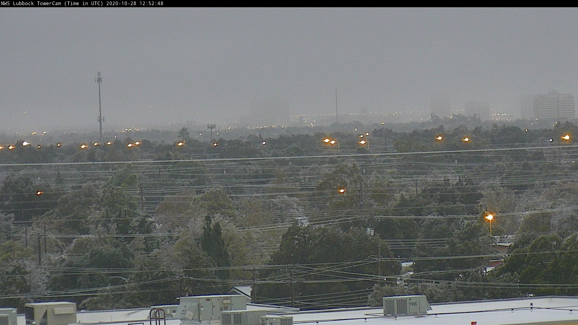
| Icy scene from the south side of Lubbock early Wednesday morning (28 October 2020). | |||
|
A strong cold front moved through the South Plains during the day on Sunday (25 October). Much cooler air and low clouds moved in behind the front, with temperatures dropping into the 40s behind the front during the afternoon. The colder air continued to build into the region on breezy northerly winds through Sunday night and into Monday. Temperatures tumbled below the freezing mark across the southern Texas Panhandle late Sunday evening. The freezing line advanced southward through the South and Rolling Plains early Monday morning. |
|||
 |
|||
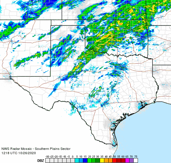
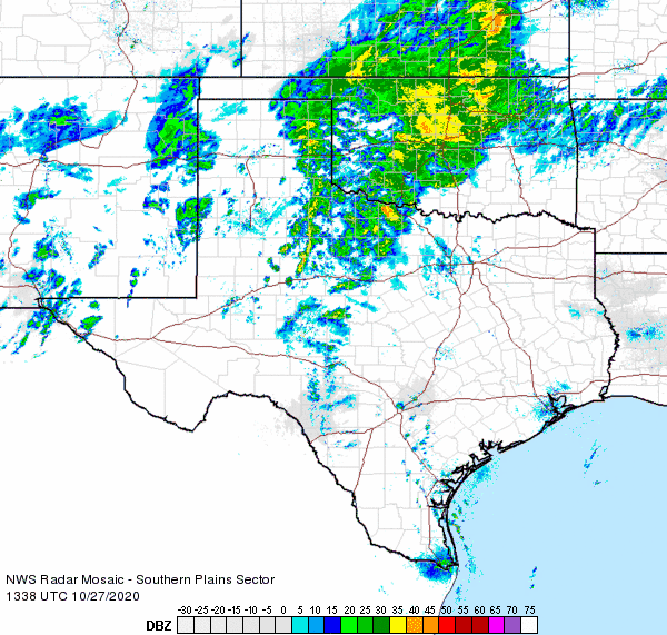
| Regional radar animation valid from 7:18 am to 8:28 am on 26 October 2020. | |||
| In addition to the cold, areas of drizzle and freezing drizzle developed late Sunday evening and persisted into Monday morning. The freezing drizzle caused a light glaze of ice to accumulate on exposed surfaces, making bridges and overpasses particularly slick and contributing to numerous wrecks. Scattered freezing rain and sleet showers, accompanied by lightning, also developed early Monday morning in response to a passing upper level disturbance. These showers left swaths of heavier freezing rain and sleet as they affected parts of the central and eastern South Plains, the southeast Texas Panhandle and much of the Rolling Plains. The heavier frozen precipitation made travel even more difficult in spots on Monday as temperatures continued to drop through the day, reaching the upper teens to middle 20s by early Tuesday. This early season cold air set new record lows both Monday and Tuesday in Lubbock, when the mercury dipped to 23 and 22 degrees, respectively. | |||
 |
|||
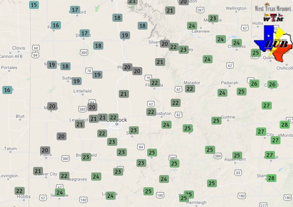
| Low temperatures recorded the West Texas Mesonet on Tuesday (27 October 2020). | |||
| The wintry mix diminished and shifted east by Monday afternoon, but light freezing drizzle and areas of light snow continued through the day and into Monday night. In addition to numerous vehicle accidents, the cold and wintry conditions (icing aloft) may have contributed to a plane crash in Lubbock, near 37th Street and Avenue A, late Monday afternoon. One person, the pilot, perished in the crash, but amazingly no one on the ground was injured. | |||
 |
|||
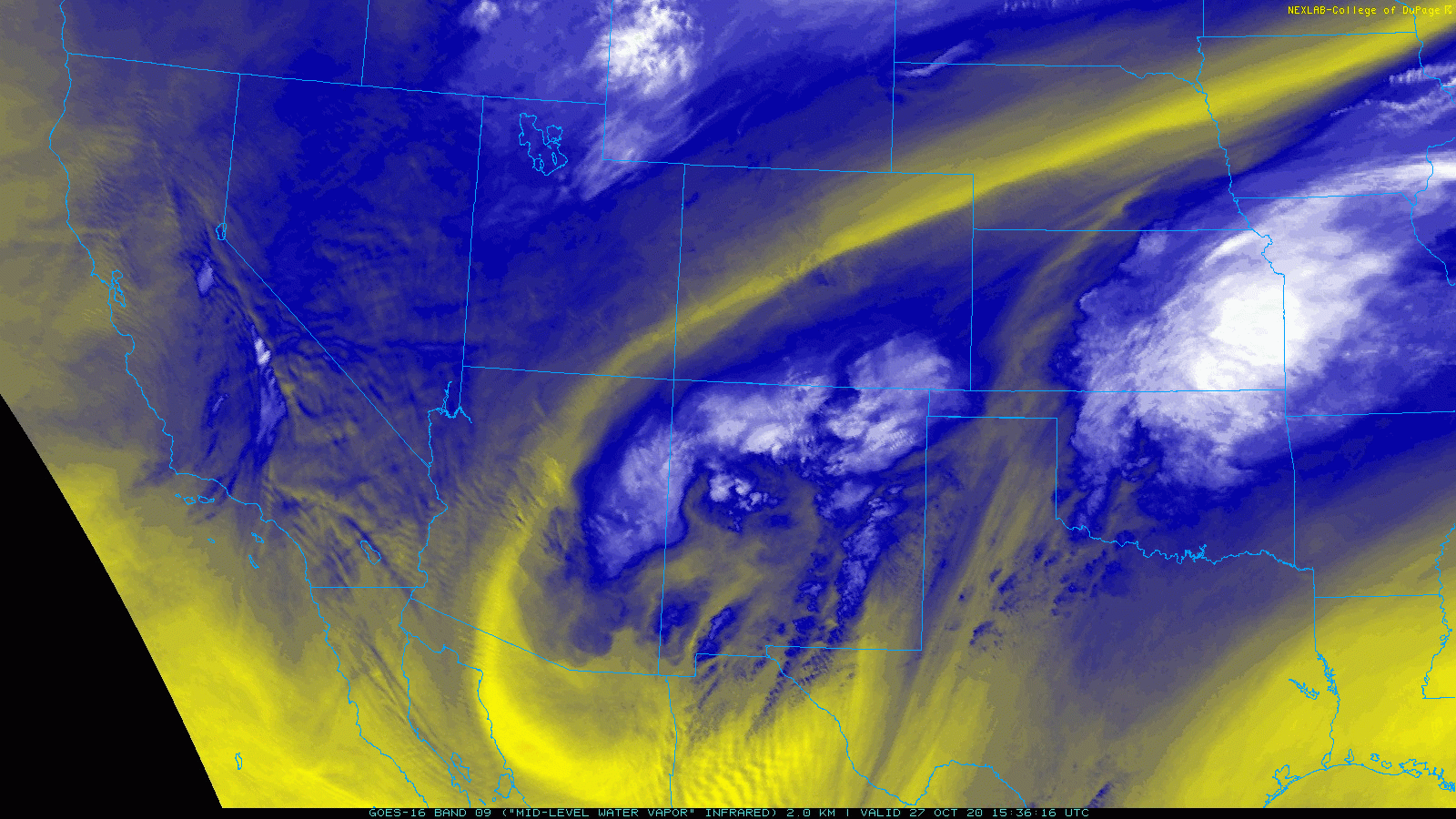
| Mid-level water vapor loop captured from GOES-16 on Tuesday morning (27 October 2020). The large storm system that brought the rounds of wintry weather to West Texas can be seen spinning over New Mexico, Arizona and northern Mexico. | |||
| Another round of heavier wintry precipitation visited the South Plains region early Tuesday, as a second upper level disturbance raced by. This produced more bursts of thundersleet and freezing rain, accompanied by lightning, as temperatures remained mostly in the 20s. | |||
|
|
|||
 |
|||
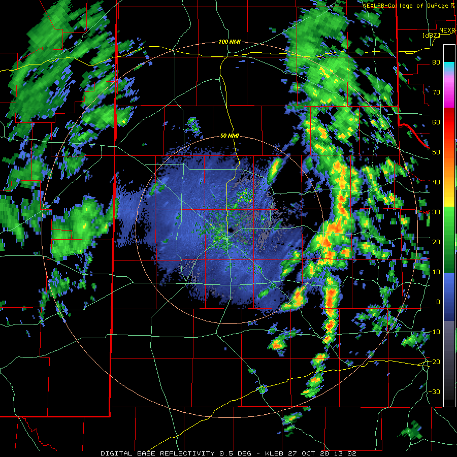
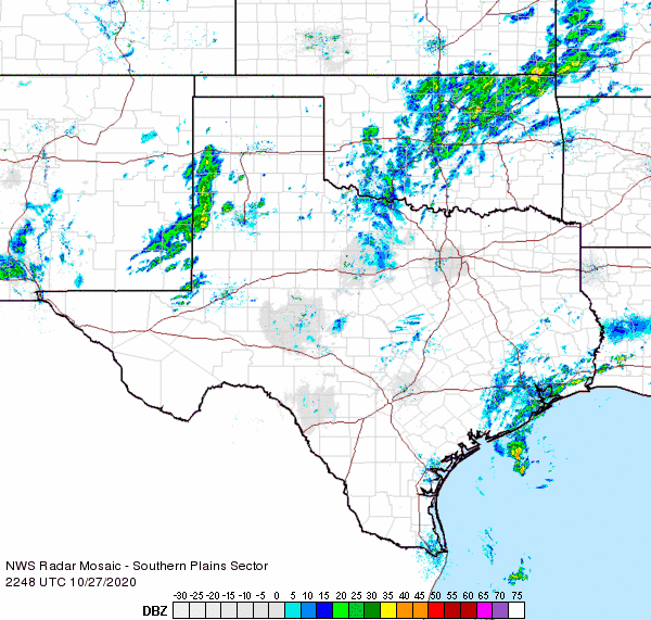
| Lubbock radar animation valid from 8:02 am to 10:18 am on Tuesday (27 October 2020). A regional radar animation, valid from 8:38 am to 9:48 am can be VIEWED HERE. | |||
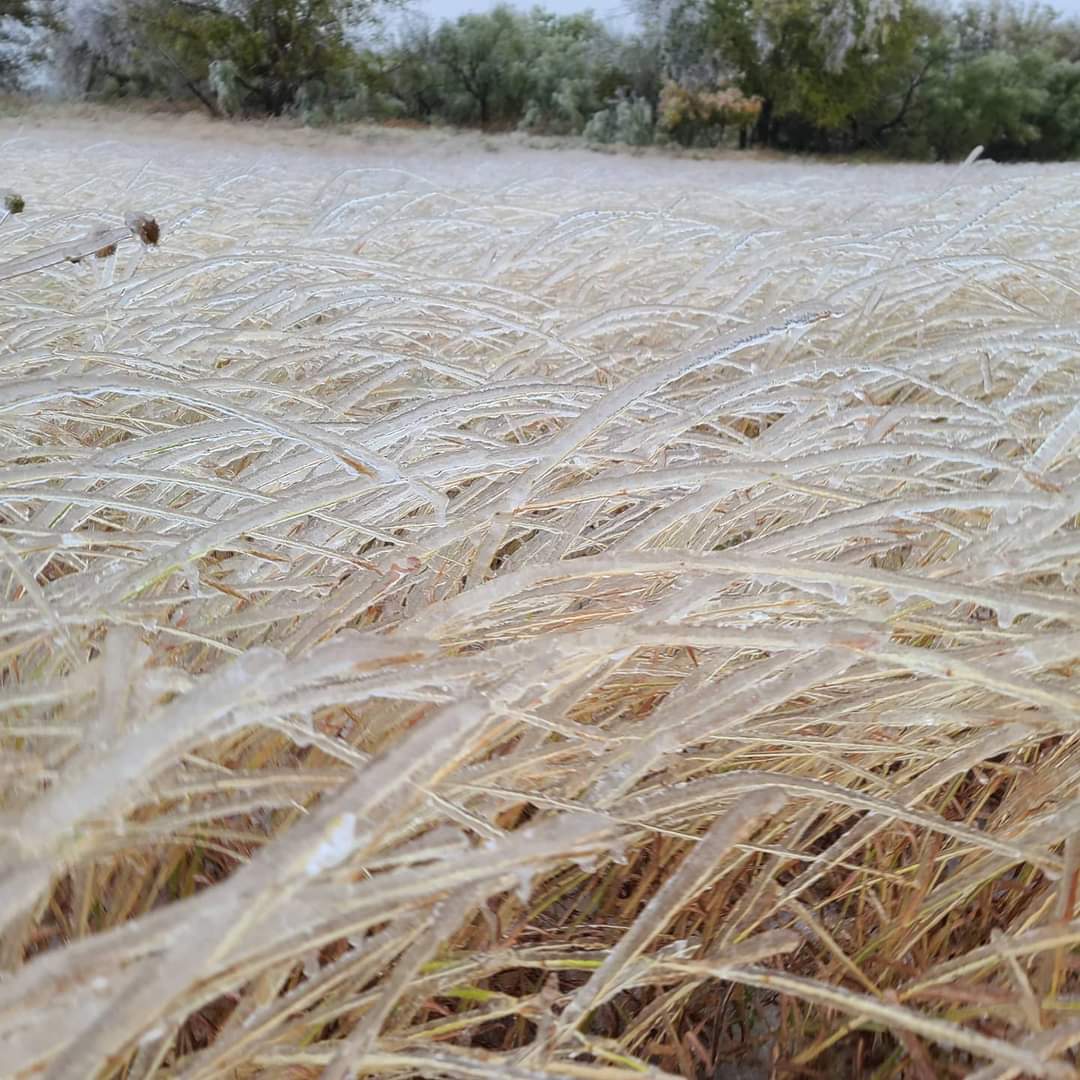
| Ice covered all exposed objects making for a pretty, but often destructive scene. Below are a couple of pictures taken from around the area after Tuesday morning's round of sleet and freezing rain. | |||
|
|||
| Ice covered grass near Childress Tuesday (27 October 2020). The picture is courtesy of Kasey Blacksher Smith via Farrah Holcomb. | |||
 |
|||
| A sleet and ice coverage Jones AT&T Stadium at Texas Tech on Tuesday (27 October 2020). The image is courtesy of Texas Tech Football. | |||
|
A lull followed Tuesday afternoon, but it didn't last long as widespread frozen precipitation redeveloped as the primary upper level storm system approached from Far West Texas Tuesday evening. A large swath of thundersleet and freezing rain engulfed West Texas, initially affecting locations on the Caprock Tuesday evening, spreading into the southeast Texas Panhandle and Rolling Plains during the late evening and overnight hours. |
|||
 |
|||
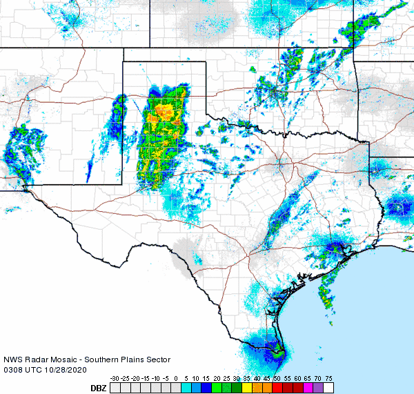
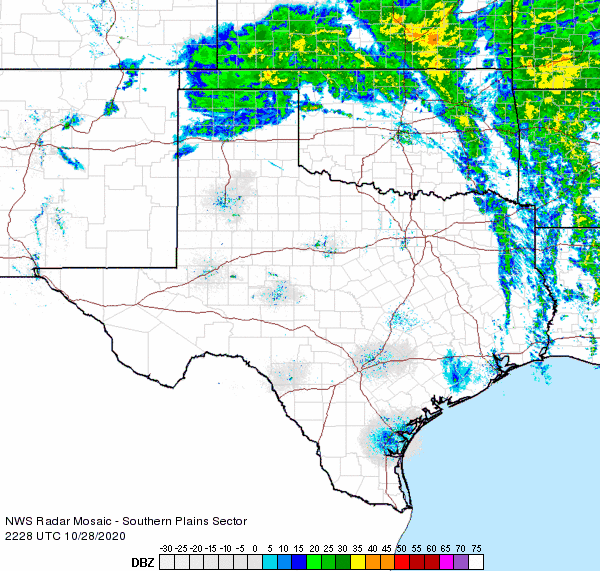
| Regional radar animation valid from 10:08 pm to 11:18 pm on 28 October 2020. Additional radar animation can be viewed at: 5:48 pm to 6:58 pm on the 28th; and 11:38 pm on the 28th to 12:48 am on the 29th. | |||
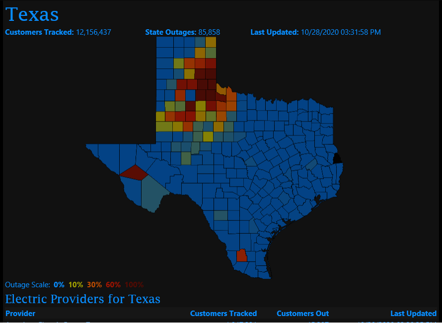
| Widespread and heavy icing occurred under this precipitation shield, creating hazardous travel and downing many tree limbs and power lines, which led to numerous power outages. The sleet did mix with and change to snow across the western South Plains and southwest Texas Panhandle as colder air aloft moved in late Tuesday evening. | |||
 |
|||
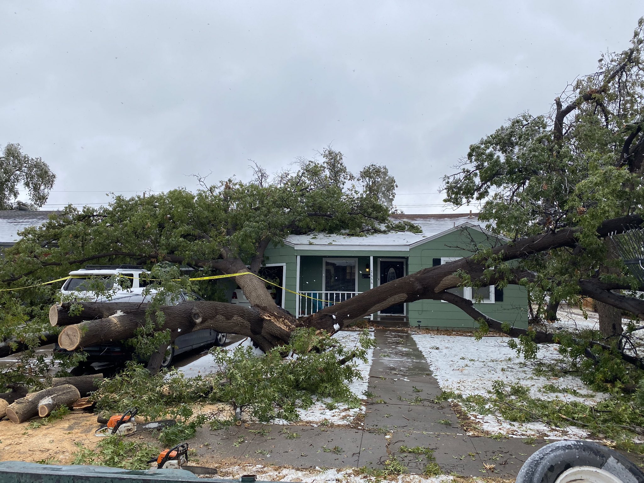
| Downed tree near 31st Street and University in Lubbock on 28 October 2020. The picture is courtesy of Matt Ernst. | |||
| Following another lull early Wednesday, scattered snow shower spread across the Caprock during the afternoon with very little impact. However, temperatures warming to near and above the freezing mark did cause its own hazards, as ice began melting and falling from trees, towers, buildings and whatever else it was stuck to. | |||
 |
|||
| Lubbock radar animation valid from 6:53 pm to 9:34 pm on 29 October 2020. A regional radar animation valid from 5:28 pm to 6:38 pm on 28 October 2020 can be VIEWED HERE. | |||
| The storm system wasn't finished with West Texas just yet, as a final band of snow developed on its north and west side and wrapped southward over the region while it was pulling away from the area Wednesday evening (28 Oct). Several inches of snow fell in the central Texas Panhandle, with an additional 1 to 2 inches falling around Friona and Dimmitt. It was just warm enough that the snow mixed with and changed to rain as it reached the central South Plains. Even as the final precipitation from the event diminish late Wednesday night, the system brought one last treat, a round of strong northerly winds through early Thursday morning. Winds gusted as high as 45 to 55+ mph over the central South Plains during the overnight, knocking down damaged branches from the preceding ice storm. | |||
 |
|||
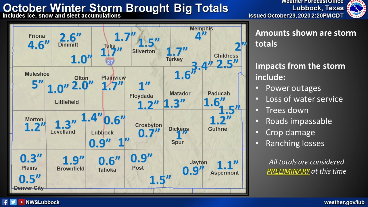
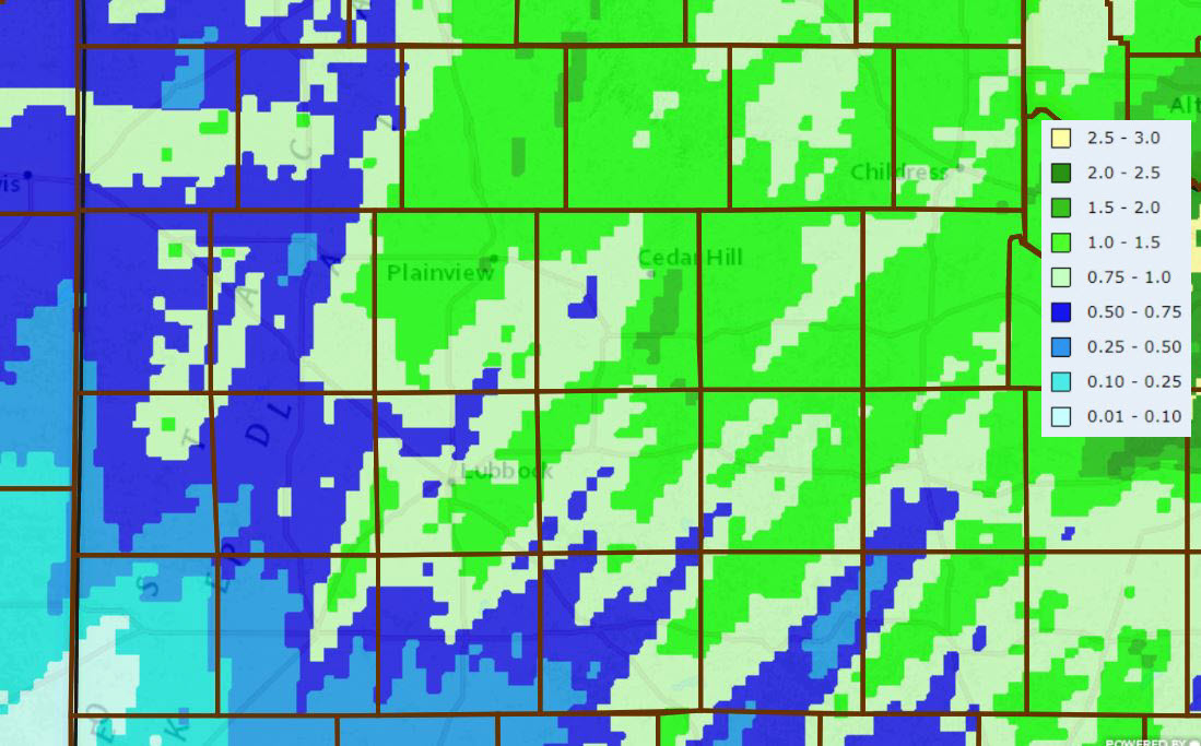
| Total ice, snow and sleet accumulations from three days of winter weather (25-28 October 2020). | |||
| Over the course of the three-day winter storm, impressive amounts of sleet and ice fell, while accumulating snow was generally confined to the southwest Texas Panhandle and northwestern South Plains. Although all of the icing did cause a lot of damage and cause cattle losses, it also brought welcome moisture to a drought-stricken region. | |||
 |
|||
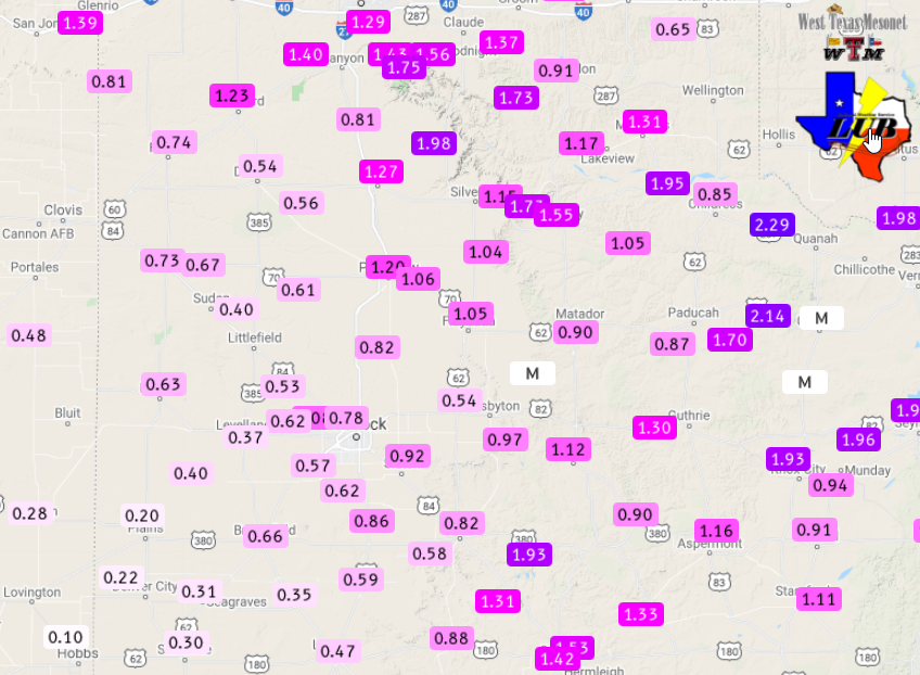
| Radar-estimated and bias-corrected 5-day liquid equivalent ending at 7 am on 29 October 2020. The totals melted precipitation, as measured by the West Texas Mesonet, can be FOUND HERE. | |||
|
Officially, the Lubbock Airport recorded 0.77 inches of liquid and 0.6 inches of sleet and snow during this late October winter storm. This was the most moisture recorded from one storm in Lubbock since the beginning of September. |
|||
 |
|||
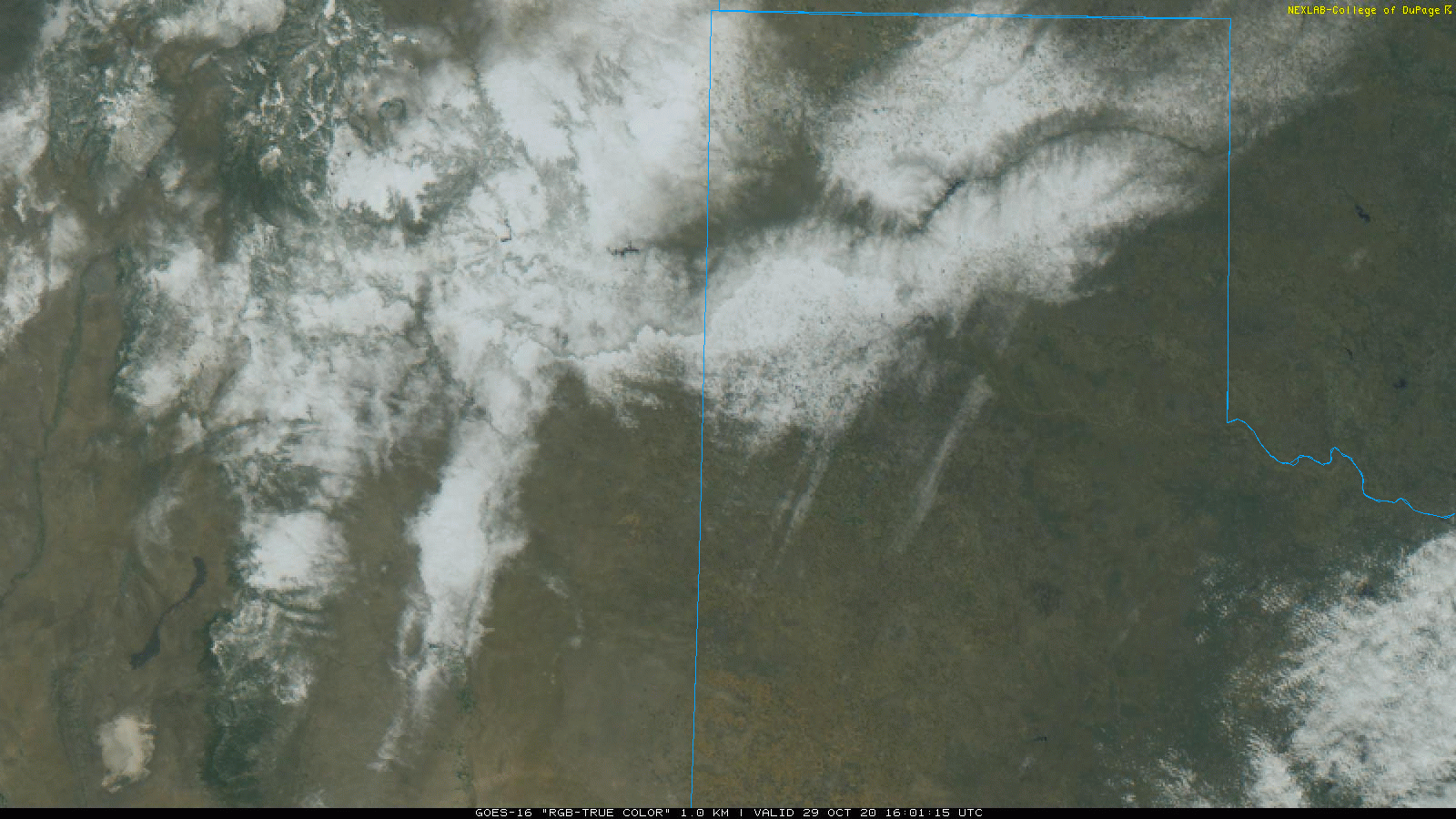
| "RGB-True Color" satellite image taken by GOES-16 at 11:01 am on 29 October 2020. | |||
| Although temperatures rose above the freezing mark late Wednesday and remained above freezing into Thursday morning, some lingering sleet and snow could still be seen from satellite after skies cleared Thursday morning. The heaviest snow followed the Canadian River Valley into the mountains of New Mexico. | |||
| The preliminary storm reports for this first winter storm of 2020-2021 season can be viewed below. | |||
PRELIMINARY LOCAL STORM REPORT...SUMMARY
NATIONAL WEATHER SERVICE LUBBOCK TX
215 PM CDT THU OCT 29 2020

..TIME...   ...EVENT...      ...CITY LOCATION...     ...LAT.LON...
..DATE...   ....MAG....      ..COUNTY LOCATION..ST.. ...SOURCE....
            ..REMARKS..

1110 AM     FREEZING RAIN    WOLFFORTH               33.51N 102.01W
10/27/2020  M0.50 INCH       LUBBOCK            TX   SOCIAL MEDIA

1109 PM     ICE STORM        TAHOKA                  33.16N 101.79W
10/27/2020                   LYNN               TX   CO-OP OBSERVER

            NUMEROUS POWER OUTAGES, PRIMARILY FROM CROSS ARMS
            BREAKING ON POWER POLES.

1133 PM     ICE STORM        15 E SILVERTON          34.47N 101.04W
10/27/2020                   BRISCOE            TX   TX DOT

            ICE DOWNED POWER LINES ALONG HIGHWAY 256 IN BRISCOE
            COUNTY. LOCATION IS ESTIMATED.

1140 PM     ICE STORM        LUBBOCK                 33.58N 101.88W
10/27/2020                   LUBBOCK            TX   EMERGENCY MNGR

            ICING HAS DOWNED NUMEROUS POWER LINES IN AND AROUND
            LUBBOCK

1148 PM     ICE STORM        TELL                    34.38N 100.39W
10/27/2020                   CHILDRESS          TX   TRAINED SPOTTER

            ICE HAS DOWNED POWER LINES AND ELECTRICITY IS OUT IN
            TELL AND CEEVEE.

1227 AM     ICE STORM        CHILDRESS               34.42N 100.25W
10/28/2020                   CHILDRESS          TX   UTILITY COMPANY

            ICE LOADING HAS RESULTED IN NUMEROUS POWER OUTAGES IN
            CHILDRESS.

0600 AM     SNOW             ABERNATHY               33.83N 101.84W
10/28/2020  M2.0 INCH        HALE               TX   PUBLIC

            2" OF SNOW/SLEET MIX REPORTED AT THE POST OFFICE.

0800 AM     ICE STORM        SPUR                    33.48N 100.85W
10/28/2020                   DICKENS            TX   PUBLIC

            POST OFFICE EMPLOYEE REPORTED A TOTAL OF 1" OF
            ICE/SLEET FOR THE EVENT.

0835 AM     SNOW             FARWELL                 34.39N 103.04W
10/28/2020  M4.0 INCH        PARMER             TX   PUBLIC

            POST OFFICE REPORTED 3-4".

0836 AM     ICE STORM        HAPPY                   34.74N 101.86W
10/28/2020                   SWISHER            TX   PUBLIC

            POST OFFICE REPORTED 1/4" OF ICE AND POWER OUT AROUND
            TOWN.

0836 AM     ICE STORM        GUTHRIE                 33.63N 100.32W
10/28/2020                   KING               TX   CO-OP OBSERVER

            0.5" OF ICE MEASURES

0840 AM     ICE STORM        ASPERMONT               33.14N 100.22W
10/28/2020                   STONEWALL          TX   PUBLIC

            1/4" OF ICE MEASURED WITH A THIN LAYER OF SNOW AND
            SLEET.

0900 AM     ICE STORM        KRESS                   34.37N 101.75W
10/28/2020                   SWISHER            TX   PUBLIC

            2" OF ICE/SLEET MIX

0900 AM     ICE STORM        3 N QUITAQUE            34.41N 101.05W
10/28/2020                   BRISCOE            TX   TX PARK SVC

            0.5" OF ICE MEASURED. POWER OUT AROUND THE AREA.

0904 AM     ICE STORM        SILVERTON               34.47N 101.30W
10/28/2020                   BRISCOE            TX   LAW ENFORCEMENT

            1.5" OF ICE/SLEET MIX... POWER IS OUT AROUND THE AREA.

0920 AM     ICE STORM        MEMPHIS                 34.73N 100.54W
10/28/2020                   HALL               TX   LAW ENFORCEMENT

            4" OF ICE/SLEET MIX... SEVERAL POWERLINES ARE DOWN
            ACROSS THE AREA.

0920 AM     SNOW             MULESHOE                34.23N 102.73W
10/28/2020  E1.0 INCH        BAILEY             TX   LAW ENFORCEMENT

0930 AM     ICE STORM        9 SE FLOYDADA           33.89N 101.23W
10/28/2020                   FLOYD              TX   CO-OP OBSERVER

            ICE ACCRUAL ONE INCH ON LINES, STRUCTURES. POWER POLES
            AND WIRES DOWN IN VICINITY.

0930 AM     ICE STORM        CHILDRESS               34.42N 100.25W
10/28/2020                   CHILDRESS          TX   LAW ENFORCEMENT

            DPS REPORTS 2-3" OF ICE/SLEET MIX WITH NO POWER IN THE
            AREA.

0936 AM     ICE STORM        FARWELL                 34.39N 103.04W
10/28/2020                   PARMER             TX   LAW ENFORCEMENT

            HIGHWAYS 60, 70, & 84 ARE ICE PACKED AND SLICK.

0940 AM     ICE STORM        13 NW CHILDRESS         34.56N 100.41W
10/28/2020                   CHILDRESS          TX   CO-OP OBSERVER

            TREE LIMBS DOWN UNDER HEAVY ICING. CALVES PERISHED.

0941 AM     SNOW             1 SSE DIMMITT           34.53N 102.31W
10/28/2020  M2.5 INCH        CASTRO             TX   LAW ENFORCEMENT

            2.5" OF SNOW/SLEET MIXED.

1018 AM     SNOW             AMHERST                 34.01N 102.41W
10/28/2020  M1.0 INCH        LAMB               TX   PUBLIC

            MIX OF SNOW/SLEET AT POST OFFICE

1022 AM     SNOW             LITTLEFIELD             33.92N 102.33W
10/28/2020  E2.0 INCH        LAMB               TX   LAW ENFORCEMENT

            SHERIFF OFFICE REPORTED 1-2" OF SNOW/SLEET.

1030 AM     SNOW             OLTON                   34.18N 102.14W
10/28/2020  M2.0 INCH        LAMB               TX   PUBLIC

            2" OF SNOW/SLEET MIX REPORTED AT THE POST OFFICE

1053 AM     SNOW             EDMONSON                34.28N 101.89W
10/28/2020  M2.0 INCH        HALE               TX   PUBLIC

            AT EDMONSON POST OFFICE

1121 AM     ICE STORM        FLOYDADA                33.98N 101.34W
10/28/2020                   FLOYD              TX   LAW ENFORCEMENT

            0.5" OF ICE MEASURED AND POWER IS OUT IN MUCH OF THE
            AREA.

0130 PM     SNOW             BROWNFIELD              33.18N 102.27W
10/28/2020  M3.0 INCH        TERRY              TX   LAW ENFORCEMENT

0800 AM     SNOW             4 SSW LUBBOCK           33.53N 101.88W
10/29/2020  M1.0 INCH        LUBBOCK            TX   NWS OFFICE

            STORM TOTAL SNOW/SLEET TOTAL.

0800 AM     SNOW             VIGO PARK               34.65N 101.50W
10/29/2020  E1.7 INCH        SWISHER            TX   CO-OP OBSERVER

            STORM TOTAL SNOW/SLEET FALL.

0800 AM     SNOW             TURKEY                  34.39N 100.90W
10/29/2020  E1.7 INCH        HALL               TX   CO-OP OBSERVER

            STORM TOTAL SNOW/SLEET FALL.

0800 AM     SNOW             TULIA                   34.54N 101.77W
10/29/2020  E1.7 INCH        SWISHER            TX   CO-OP OBSERVER

            STORM TOTAL SNOW/SLEET FALL.

0800 AM     SNOW             SHALLOWATER             33.69N 101.99W
10/29/2020  E1.4 INCH        LUBBOCK            TX   NWS EMPLOYEE

            STORM TOTAL SNOW/SLEET FALL.

0800 AM     SNOW             PLAINVIEW               34.19N 101.72W
10/29/2020  E1.7 INCH        HALE               TX   CO-OP OBSERVER

            STORM TOTAL SNOW/SLEET FALL.

0800 AM     SNOW             10 S PADUCAH            33.87N 100.30W
10/29/2020  E1.6 INCH        COTTLE             TX   CO-OP OBSERVER

            STORM TOTAL SNOW/SLEET FALL.

0800 AM     SNOW             NORTHFIELD              34.29N 100.60W
10/29/2020  E3.4 INCH        MOTLEY             TX   CO-OP OBSERVER

            STORM TOTAL SNOW/SLEET FALL.

0800 AM     SNOW             MULESHOE                34.23N 102.73W
10/29/2020  E5.0 INCH        BAILEY             TX   CO-OP OBSERVER

            STORM TOTAL SNOW/SLEET FALL.

0800 AM     SNOW             MORTON                  33.72N 102.76W
10/29/2020  E1.2 INCH        COCHRAN            TX   CO-OP OBSERVER

            STORM TOTAL SNOW/SLEET FALL.

0800 AM     SNOW             LEVELLAND               33.58N 102.36W
10/29/2020  E1.3 INCH        HOCKLEY            TX   CO-OP OBSERVER

            STORM TOTAL SNOW/SLEET FALL.

0800 AM     SNOW             LAKE ALAN HENRY         33.06N 101.05W
10/29/2020  E1.5 INCH        GARZA              TX   CO-OP OBSERVER

            STORM TOTAL SNOW/SLEET FALL.

0800 AM     SNOW             HART                    34.39N 102.11W
10/29/2020  E1.0 INCH        CASTRO             TX   CO-OP OBSERVER

            STORM TOTAL SNOW/SLEET FALL.

0800 AM     SNOW             GUTHRIE                 33.63N 100.32W
10/29/2020  E1.2 INCH        KING               TX   CO-OP OBSERVER

            STORM TOTAL SNOW/SLEET FALL.

0800 AM     SNOW             FRIONA                  34.64N 102.72W
10/29/2020  E4.6 INCH        PARMER             TX   CO-OP OBSERVER

            STORM TOTAL SNOW/SLEET FALL.

0800 AM     SNOW             DIMMITT                 34.55N 102.32W
10/29/2020  E2.6 INCH        CASTRO             TX   CO-OP OBSERVER

            STORM TOTAL SNOW/SLEET FALL.

0800 AM     SNOW             CHILDRESS               34.42N 100.25W
10/29/2020  E1.6 INCH        CHILDRESS          TX   CO-OP OBSERVER

            STORM TOTAL SNOW/SLEET FALL.

0800 AM     SNOW             BROWNFIELD              33.18N 102.27W
10/29/2020  E1.9 INCH        TERRY              TX   CO-OP OBSERVER

            STORM TOTAL SNOW/SLEET FALL

