
Early June continued the stretch of active weather with several rounds of mostly evening and overnight thunderstorms. A lingering storm system across the Desert Southwest was the primary instigator for this activity. As the storm system finally moved closer, it fueled a final and dramatic round of thunderstorms that raced across the South Plains and Rolling Plains Wednesday evening (5 June).
 |
|
|
Lubbock WSR-88D radar animation valid from 5:17 pm to 6:56 pm on 5 June 2019. An additional radar animation is available at: 8:49 pm to 10:09 pm.
|
The thunderstorms initially developed across eastern New Mexico and the northwest South Plains. These storms quickly evolved into a broken line as they raced eastward across the southern Texas Panhandle, South Plains and Rolling Plains.
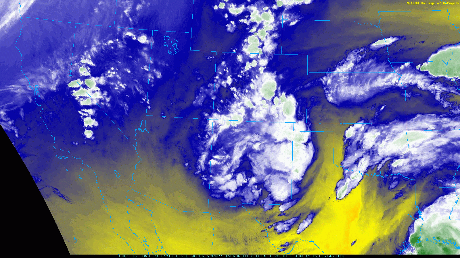
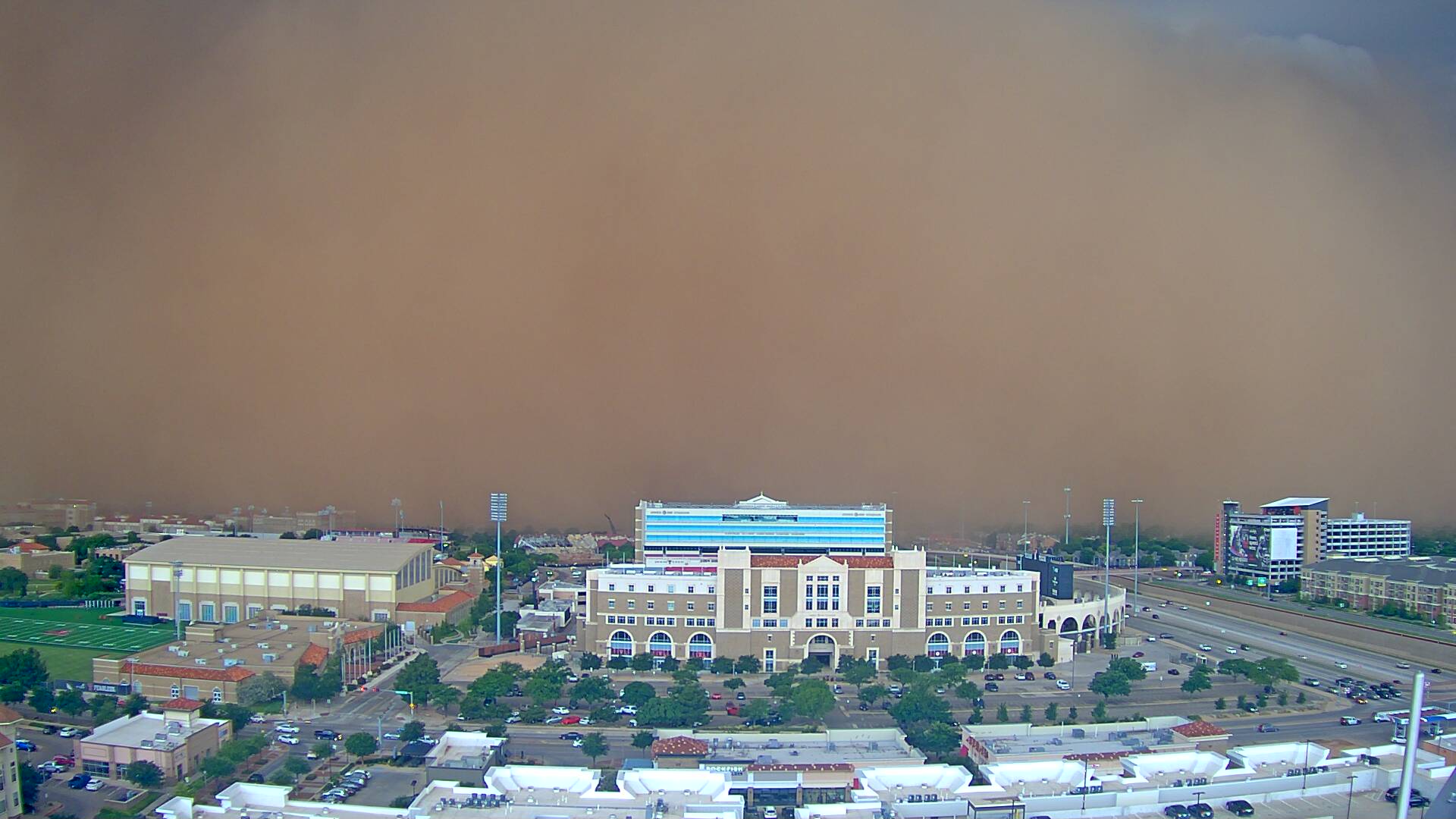
Strong winds, gusting from 45 to 60+ mph, pushed out ahead of the line of storms. These winds were enough to make the storms severe, but more impressive was the dust that the winds lofted. A wall of wind and dust, in the form of a haboob, rolled across the central and eastern South Plains and right off the Caprock.
 |
 |
 |
|
Pictures taken from the Science Spectrum in Lubbock on Wednesday evening, 5 June 2019. From left-to-right the images were gathered at 6 pm, 6:05 pm and 6:13 pm, respectively.
|
||
The wall of dust out ahead of the thunderstorms made for an ominous sight as it approached. The visibility dropped to near zero in spots as the haboob moved through, which created dangerous travel. Several Dust Storm Warnings were issued in addition to Severe Thunderstorm Warnings.
 |
|
|
A wall of wind and dust about to engulf Jones AT&T Stadium on the Texas Tech Campus. The picture was taken at 6:13 pm on 5 June 2019. The image is courtesy of KAMC.
|
Officially the Lubbock Airport reported a peak wind gust of 47 mph along with 1/4 mile visibility as the haboob moved through. Thankfully, the thick dust didn't last long, as the thunderstorms that generated the strong outflow winds brought a period of moderate to heavy rain.

In addition to the widespread wind and dust, almost everyone recorded at least a little rainfall. Rain totals of a couple tenths of an inch to an inch were common during June 5th. Officially, Lubbock recorded 0.46 inches, which lifted the yearly total to 8.10 inches.

Over the one-week stretch from late May into early June, the entire region saw rainfall. Most spots recorded 1 to 3 inches of rain, with even heavier totals across the southern Rolling Plains. The one spot that largely managed to miss out was around Muleshoe, in northern
Bailey County, where under an inch (and in spots less than 1/2 inch) fell.
A listing of the Preliminary Local Storm Reports (LSRs) for June 5th can be viewed below:
PRELIMINARY LOCAL STORM REPORT...SUMMARY
NATIONAL WEATHER SERVICE LUBBOCK TX
1103 AM CDT THU JUN 06 2019

..TIME...   ...EVENT...      ...CITY LOCATION...     ...LAT.LON...
..DATE...   ....MAG....      ..COUNTY LOCATION..ST.. ...SOURCE....
            ..REMARKS..

0500 PM     TSTM WND GST     2 NE FRIONA             34.65N 102.69W
06/05/2019  M60 MPH          PARMER             TX   MESONET

0505 PM     TSTM WND GST     2 NE FRIONA             34.65N 102.69W
06/05/2019  M68 MPH          PARMER             TX   MESONET

0540 PM     HAIL             LEVELLAND               33.58N 102.36W
06/05/2019  E0.75 INCH       HOCKLEY            TX   CO-OP OBSERVER

            HAIL AS BIG AS MARBLE SIZE. STRONG WINDS TOO, BUT NO
            KNOWN SIGNIFICANT DAMAGE AND NOT MUCH DUST. TIME
            ESTIMATED FROM RADAR.

0545 PM     TSTM WND GST     6 SSW ANTON             33.73N 102.19W
06/05/2019  M59 MPH          HOCKLEY            TX   MESONET

0615 PM     TSTM WND GST     6 SSW WOLFFORTH         33.42N 102.05W
06/05/2019  M61 MPH          LUBBOCK            TX   MESONET

0623 PM     DUST STORM       2 N NEW DEAL            33.76N 101.84W
06/05/2019                   LUBBOCK            TX   LAW ENFORCEMENT

            LAW ENFORCEMENT REPORTED NEAR ZERO VISIBILITY ON I27 IN
            NORTHERN LUBBOCK COUNTY.

0623 PM     DUST STORM       6 NNE LUBBOCK           33.67N 101.82W
06/05/2019                   LUBBOCK            TX   ASOS

            1/4MI VISIBILITY DUE TO DUST REPORTED AT KLBB WITH 46
            MPH WIND GUST AT 623PM CDT.

0635 PM     TSTM WND GST     1 S PLAINVIEW           34.16N 101.72W
06/05/2019  M58 MPH          HALE               TX   AWOS

0705 PM     TSTM WND GST     2 NNE FLOYDADA          34.00N 101.33W
06/05/2019  M60 MPH          FLOYD              TX   MESONET

0715 PM     TSTM WND GST     2 NNE FLOYDADA          34.00N 101.33W
06/05/2019  M59 MPH          FLOYD              TX   MESONET

0725 PM     HAIL             9 SE FLOYDADA           33.89N 101.23W
06/05/2019  E1.00 INCH       FLOYD              TX   CO-OP OBSERVER

            TIME ESTIMATED FROM RADAR

0740 PM     TSTM WND DMG     2 E FLOMOT              34.23N 100.95W
06/05/2019                   MOTLEY             TX   CO-OP OBSERVER

            WIND DAMAGE TO COTTON CROP. TIME ESTIMATED FROM RADAR.

0744 PM     TSTM WND GST     CAPROCK CANYON SP       34.41N 101.06W
06/05/2019  M61 MPH          BRISCOE            TX   MESONET

0834 PM     TSTM WND GST     2 W CHILDRESS           34.43N 100.28W
06/05/2019  M64 MPH          CHILDRESS          TX   ASOS

