Lubbock, TX
Weather Forecast Office

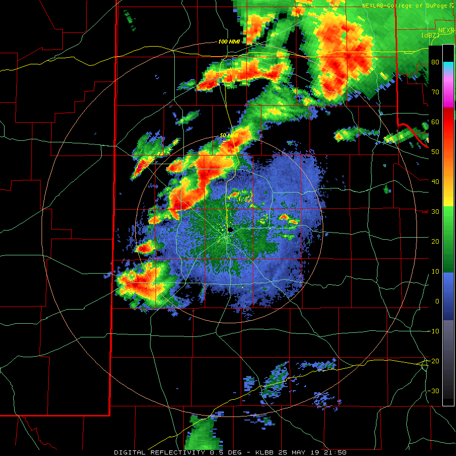
May 25th, 2019, was one in a series of active weather days this May. Abundant moisture and instability in the region were acted on by a dryline to the west and unsettled southwest flow aloft. The combination caused thunderstorms to erupt across the Texas Panhandle back into the western South Plains during the afternoon. This activity repeatedly tracked northeastward over the same area into the evening hours, causing flooding rains. In addition, several of the storms began to rotate, producing funnel clouds and at least four brief tornadoes.
 |
 |
|
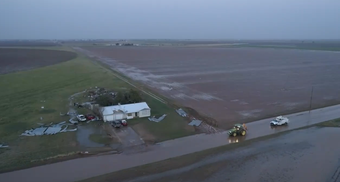
Damage incurred to a homestead about 2 miles west of Cotton Center. The images are courtesy of Fletcher Aerial Solutions.
|
|
One of the tornadoes touched down near Cotton Center just after 6 pm. This tornado tracked from about 3.5 miles west-northwest of town to just east-northeast of town. Unfortunately, one farmstead was impacted west of town. The tornado destroyed a shed and caused minor roof damage to the adjacent home.

Another tornado briefly touched down on the north side of Plainview about 20 minutes earlier. This tornado was associated with storm immediately in advance of the one that brought the tornado to the Cotton Center area. This tornado downed a cell phone tower, toppled a mobile home that was in transit and threw a couple of semi trailers.
 |
 |
|
Collapsed cell phone tower on the north side of Plainview. The images are courtesy of Fletcher Aerial Solutions.
|
|
The most extreme damage, the downed cell phone tower, incurred an EF-2 damage rating, consistent with peak winds of 110 to 132 mph. Although fairly intense, the tornado was not on the ground very long.
The destroyed mobile home, a flipped semi trailer and other debris can be seen in the below images. This damage was immediately to the west of where the cell phone tower that fell was located. All of this damage was near the intersection of North Columbia Street and CR 65 on the north edge of Plainview.
 |
 |
|
Destroyed mobile home and flipped semi on the north side of Plainview. The images are courtesy of Fletcher Aerial Solutions.
|
|
A final possible brief tornado was observed as the storms moved into the southeast Texas Panhandle, just southwest of Memphis. No known damage occurred from this tornado or another brief tornado that occurred early in the evening west of Anton. Thankfully, no people were injured or killed with the tornado activity Saturday afternoon or evening (25 May).
 |
|
|
Funnel cloud and possible tornado between Lakeview and Eli around 7:40 pm on 25 May 2019. The picture is courtesy of Cort Scholten.
|
A damage survey was conducted around Plainview the next day by a team out of the National Weather Service in Lubbock. To view the complete damage survey results, go to the NWS Damage Assessment Viewer (DAT). Once on the DAT page select "Lubbock" for your Office ID. Then select a begin date of 05/24/2019 and an end date of 05/26/2019 toward the top right of the page and click "Filter". At this point the relevant damage survey points east of Anton should be visible. You can then zoom in and select the points to view more details and images.
 |
|
|
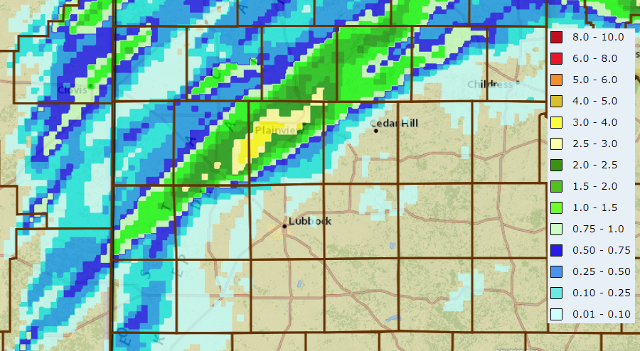
24-hour radar-estimated and bias-correct rain totals ending at 7 am on 26 May 2019. Rain totals measured by the West Texas Mesonet over this same period can be VIEWED HERE.
|
Not to be overlooked, the training thunderstorm dumped a quick 1 to 3+ inches of rain in a swath from near Littlefield through Plainview and Silverton. The torrential rain caused extensive flooding, especially in and around Plainview. The West Texas Mesonet recorded a peak rainfall of 3.12 inches at the Plainview site during this event.
The NWS Damage Survey, as well as the Preliminary Storm Reports for this active weather day can be found below:
PUBLIC INFORMATION STATEMENT...CORRECTED
NATIONAL WEATHER SERVICE LUBBOCK TX
354 PM CDT Mon May 27 2019

...NWS Damage Survey for 05/25/2019 Tornado Event...

.Tornado 1 - 8 WSW Anton, TX...

Rating:                   EF-U
Estimated Peak Wind:      Unknown

Path length:              1.0 Mile
Path width:               Unknown
Fatalities:               0
Injuries:                 0

Start date:               05/25/2019
Start time:               4:59 PM CDT
Start location:           8 WSW Anton / Hockley County / TX
Start Lat/Lon:            33.7796 / -102.2978

End date:                 05/25/2019
End time:                 5:01 PM CDT
End location:             7 WSW Anton / Hockley County / TX
End_lat/lon:              33.7823 / -102.2797

Times and locations based on storm chaser reports and radar data.
Unable to perform survey due to flooded roads and will try to
survey once drier conditions are in place.

.Tornado 2 - Plainview, TX...

Rating:                   EF-2
Estimated Peak Wind:      110-132 MPH

Path length:              0.89 Miles
Path width:               100 Yards
Fatalities:               0
Injuries:                 0

Start date:               05/25/2019
Start time:               5:39 PM CDT
Start location:           2.85 NNW Plainview
Start Lat/Lon:            34.2293 / -101.7126

End date:                 05/25/2019
End time:                 5:44 PM CDT
End location:             2.75 NNE Plainview
End_lat/lon:              34.2274 / -101.6977

Tornado development started west of Interstate 27 around 5:36 PM
CDT based on storm chaser images. The first indications of damage
occurred near the intersection of the north-bound Interstate 27
off-ramp and N Columbia Street where tin roofs were blown off
storage buildings. Damage then continued south and east towards
the intersection of N Columbia Street and Fence Road where a small
out building was destroyed and a mobile home that was being
transported on a flatbed trailer was blown over and destroyed. The
tornado started to move east near or over County Road 65/E 34th
Street where several trees had damage and a small out building was
destroyed. On County Road 65 halfway between N Columbia Street
and Well Road, the most significant damage occurred to a trussed
cell phone tower was destroyed and fell across County Road 65. The
tornado dissipated shortly after crossing Well Road north of
County Road 65.

.Tornado 3 - Cotton Center, TX...

Rating:                   EF-U
Estimated Peak Wind:      Unknown

Path length:              4.66 Miles
Path width:               100 Yards
Fatalities:               0
Injuries:                 0

Start date:               05/25/2019
Start time:               6:08 PM CDT
Start location:           3.5 WNW Cotton Center / Hale County / TX
Start Lat/Lon:            34.0022 / -102.0567

End date:                 05/25/2019
End time:                 6:16 PM CDT
End location:             1 ENE Cotton Center / Hale County / TX
End_lat/lon:              34.0032 / -101.9757

Multiple storm chaser photographs and video along with radar data
were used to estimate start time and location for this tornado.
Moving over mainly farm and ranch land, there were no damage
indicators hit to provide an EF Rating. The only indications of
damage were an overturned center pivot irrigation system near a
curve of Farm-to-Market 37 2.5 miles WNW of Cotton Center. A
cotton trailer and livestock feed bunk were also pulled across the
road near this location. The tornado continued moving east
passing one mile north of Cotton Center and no damage was found
near Farm to Market 179 where the path crossed the road. The
tornado dissipated 1 mile ENE of Cotton Center and poor road
conditions prevented a survey to see if any further damage
occurred near this point.

.Tornado 4 - 5.5 Miles SW of Memphis / Eli, TX...

Rating:                   EF-U
Estimated Peak Wind:      Unknown

Path length:              0.0 Miles
Path width:               Unknown
Fatalities:               0
Injuries:                 0

Start date:               05/25/2019
Start time:               7:40 PM CDT
Start location:           5.5 SW Memphis / Hall County / TX
Start Lat/Lon:            34.6986 / -100.8289

End date:                 05/25/2019
End time:                 7:41 PM CDT
End location:             5.5 SW Memphis / Hall County / TX
End_lat/lon:              34.6986 / -100.8289

A brief tornado was photographed by storm chasers near the ghost
town of Eli, TX. Times and location based on radar data and
storm chaser reports. Survey not performed for this tornado.

EF Scale:  The Enhanced Fujita Scale Classifies Tornadoes into
the following categories.

EF0...Weak......65 to 85 MPH
EF1...Weak......86 to 110 MPH
EF2...Strong....111 to 135 MPH
EF3...Strong....136 to 165 MPH
EF4...Violent...166 To 200 MPH
EF5...Violent...>200 MPH

Note:
The information in this statement is preliminary and subject to
change pending final review of the events and publication in NWS
Storm Data.

$$

Jordan/James
PRELIMINARY LOCAL STORM REPORT...SUMMARY
NATIONAL WEATHER SERVICE LUBBOCK TX
946 PM CDT SAT MAY 25 2019

..TIME...   ...EVENT...      ...CITY LOCATION...     ...LAT.LON...
..DATE...   ....MAG....      ..COUNTY LOCATION..ST.. ...SOURCE....
            ..REMARKS..

0400 PM     HAIL             SILVERTON               34.47N 101.30W
05/25/2019  E1.00 INCH       BRISCOE            TX   FIRE DEPT/RESCUE

            WINDS 40-50 MPH

0450 PM     TSTM WND GST     3 N PLAINS              33.23N 102.83W
05/25/2019  M65 MPH          YOAKUM             TX   MESONET

            MEASURED BY THE PLAINS WEST TEXAS MESONET

0450 PM     TSTM WND DMG     PLAINS                  33.19N 102.83W
05/25/2019                   YOAKUM             TX   LAW ENFORCEMENT

            LARGE TREE DOWN IN PLAINS BLOCKING A ROADWAY. TIME OF
            DAMAGE ESTIMATED.

0455 PM     TSTM WND GST     3 N PLAINS              33.23N 102.84W
05/25/2019  M66 MPH          YOAKUM             TX   MESONET

            MEASURED BY THE PLAINS WEST TEXAS MESONET

0456 PM     WALL CLOUD       6 N WHITHARRAL          33.82N 102.33W
05/25/2019                   HOCKLEY            TX   TRAINED SPOTTER

            STORM IS ROTATING

0508 PM     FUNNEL CLOUD     2 W ANTON               33.81N 102.20W
05/25/2019                   HOCKLEY            TX   FIRE DEPT/RESCUE

            SEEING A FUNNEL CLOUD FROM FM 597 ABOUT 1 MILE WEST OF
            HIGHWAY 385

0520 PM     FLOOD            6 SE LITTLEFIELD        33.86N 102.26W
05/25/2019                   LAMB               TX   CO-OP OBSERVER

            TORRENTIAL RAINFALL CAUSING INUNDATION FLOODING FOR THE
            SECOND DAY IN A ROW.

0525 PM     FUNNEL CLOUD     7 NNW ANTON             33.90N 102.21W
05/25/2019                   LAMB               TX   FIRE DEPT/RESCUE

            ABERNATHY FD SPOTTED A BRIEF FUNNEL. LOCATION IS
            ESTIMATED FROM RADAR.

0530 PM     FUNNEL CLOUD     5 SE SETH WARD          34.16N 101.63W
05/25/2019                   HALE               TX   TRAINED SPOTTER

            LOCATION IS WHERE OBSERVER WAS LOCATED. THEY SPOTTED
            THE FUNNEL WELL TO THEIR WEST, CLOSE TO PLAINVIEW.

0540 PM     TSTM WND DMG     PLAINVIEW               34.19N 101.72W
05/25/2019                   HALE               TX   TRAINED SPOTTER

            STRONG WINDS BLEW OVER A SEMI. A CELL TOWER WAS BLOWN
            DOWN. A MOBILE HOME WAS FLIPPED OVER. DAMAGE MAY HAVE
            BEEN RELATED TO A STRONG CIRCULATION/TORNADO THAT MOVED
            BY THE NORTH SIDE OF TOWN. TIME OF OCCURRENCE ESTIMATED.

0550 PM     TSTM WND DMG     PLAINVIEW               34.19N 101.72W
05/25/2019                   HALE               TX   EMERGENCY MNGR

            UP TO 2,400 PEOPLE WITHOUT POWER IN PLAINVIEW
            IMMEDIATELY AFTER THE STORM PASSAGE

0555 PM     FUNNEL CLOUD     7 NW SILVERTON          34.54N 101.39W
05/25/2019                   BRISCOE            TX   BROADCAST MEDIA

            WEBCAM LOOKING NORTHWEST OUT OF SILVERTON SHOWED A
            FUNNEL CLOUD. LOCATION WAS ESTIMATED FROM RADAR.

0555 PM     FLOOD            PLAINVIEW               34.19N 101.72W
05/25/2019                   HALE               TX   LAW ENFORCEMENT

            SEVERAL ROADS IN AND AROUND PLAINVIEW ARE FLOODING.
            THEY WERE ALSO DEALING WITH A NUMBER OF ACCIDENTS.

0557 PM     TORNADO          7 NE PLAINVIEW          34.26N 101.64W
05/25/2019                   HALE               TX   TRAINED SPOTTER

            CONE TORNADO SPOTTED ABOUT 6 MILES WEST OF THE FM 2301
            AND FM 788 INTERSECTION. TORNADO WAS OBSERVED FROM 5:57
            TO 5:59 PM BEFORE BECOMING RAIN WRAPPED.

0558 PM     FLOOD            FIELDTON                34.04N 102.22W
05/25/2019                   LAMB               TX   LAW ENFORCEMENT

            LITTLEFIELD SO REPORTED THAT FM 1072 THROUGH FIELDTON
            WAS FLOODED.

0603 PM     FLOOD            1 N SPADE               33.94N 102.15W
05/25/2019                   LAMB               TX   STORM CHASER

            6 TO 12 INCHES OF RAIN FLOWING ACROSS FM 168 NORTH OF
            SPADE.

0609 PM     TORNADO          3 W COTTON CENTER       33.99N 102.04W
05/25/2019                   HALE               TX   STORM CHASER

            SPOTTER IN COTTON CENTER OBSERVING A TORNADO TO THEIR
            WEST. THE LOCATION IS ESTIMATED FROM RADAR.

0625 PM     FLOOD            PLAINVIEW               34.19N 101.72W
05/25/2019                   HALE               TX   SOCIAL MEDIA

            IMAGE OF STREET FLOODED AT WEST 6TH STREET AND HOUSTON
            STREET

0627 PM     FUNNEL CLOUD     6 W AIKEN               34.14N 101.63W
05/25/2019                   HALE               TX   TRAINED SPOTTER

            SPOTTER OBSERVED A FUNNEL CLOUD. IT IS UNCERTAIN
            WHETHER THE OBSERVER WAS LOOKING AS A SUPERCELL
            THUNDERSTORM TO THEIR NORTHEAST OR ONE TO THEIR WEST.

0646 PM     HAIL             DIMMITT                 34.55N 102.32W
05/25/2019  E1.50 INCH       CASTRO             TX   LAW ENFORCEMENT

0652 PM     TSTM WND GST     CAPROCK CANYON SP       34.41N 101.06W
05/25/2019  M61 MPH          BRISCOE            TX   MESONET

            MEASURED BY THE WEST TEXAS MESONET IN CAPROCK CANYONS
            STATE PARK

0710 PM     FLOOD            PLAINVIEW               34.19N 101.72W
05/25/2019                   HALE               TX   STORM CHASER

            INTERSECTION OF BUSINESS I-27 AND FM 194 COMPLETELY
            INUNDATED IN PLAINVIEW. WATER MAY HAVE BEEN GETTING INTO
            SOME BUSINESSES ALONG THE ROAD.

0740 PM     TORNADO          2 W MEMPHIS             34.73N 100.58W
05/25/2019                   HALL               TX   STORM CHASER

            POSSIBLE BRIEF ROPE TORNADO OBSERVED BETWEEN LAKEVIEW
            AND MEMPHIS

0746 PM     TSTM WND GST     CAPROCK CANYON SP       34.41N 101.06W
05/25/2019  M59 MPH          BRISCOE            TX   MESONET

            MEASURED BY THE WEST TEXAS MESONET. MEASURED GUST TO 58
            MPH AT 745 PM AND 59 MPH AT 746 PM.
PRELIMINARY LOCAL STORM REPORT...SUMMARY
NATIONAL WEATHER SERVICE LUBBOCK TX
518 AM CDT WED MAY 08 2019

..TIME...   ...EVENT...      ...CITY LOCATION...     ...LAT.LON...
..DATE...   ....MAG....      ..COUNTY LOCATION..ST.. ...SOURCE....
            ..REMARKS..

0403 PM     HAIL             5 N OLTON               34.25N 102.14W
05/07/2019  E1.00 INCH       LAMB               TX   SOCIAL MEDIA

0427 PM     TORNADO          7 N HALFWAY             34.29N 101.95W
05/07/2019                   HALE               TX   TRAINED SPOTTER

0450 PM     HAIL             E ROPESVILLE            33.41N 102.15W
05/07/2019  E1.00 INCH       HOCKLEY            TX   PUBLIC

0450 PM     HAIL             1 S ROPESVILLE          33.40N 102.15W
05/07/2019  E1.00 INCH       HOCKLEY            TX   PUBLIC

0512 PM     TORNADO          6 SW TULIA              34.48N 101.85W
05/07/2019                   SWISHER            TX   TRAINED SPOTTER

0525 PM     TORNADO          9 SW TULIA              34.45N 101.88W
05/07/2019                   SWISHER            TX   STORM CHASER

            VIA TWITTER PIC

0556 PM     TORNADO          9 NE TULIA              34.63N 101.66W
05/07/2019                   SWISHER            TX   STORM CHASER

0559 PM     TORNADO          10 NE TULIA             34.64N 101.65W
05/07/2019                   SWISHER            TX   TRAINED SPOTTER

            RAIN WRAPPED TORNADO

0614 PM     TSTM WND GST     5 NW VIGO PARK          34.70N 101.55W
05/07/2019  E80 MPH          SWISHER            TX   TRAINED SPOTTER

            NUMEROUS POWER LINES SNAPPED. POSSIBLE TORNADO CROSSED
            ROAD.

0620 PM     TSTM WND GST     VIGO PARK               34.65N 101.50W
05/07/2019  M69 MPH          SWISHER            TX   MESONET

0715 PM     FLASH FLOOD      6 W TULIA               34.54N 101.88W
05/07/2019                   SWISHER            TX   LAW ENFORCEMENT

            FLOODING 5 - 7 MILES WEST OF TULIA ALONG S.H. 86. ALSO
            FLOODING NW OF TULIA WEST OF FM 1424.

0818 PM     HAIL             KIRKLAND                34.39N 100.07W
05/07/2019  E1.00 INCH       CHILDRESS          TX   LAW ENFORCEMENT

            INTENSE QUARTER SIZE HAIL

1107 PM     HAIL             4 WSW LUBBOCK           33.55N 101.94W
05/07/2019  E0.75 INCH       LUBBOCK            TX   TRAINED SPOTTER

1222 AM     TSTM WND GST     CAPROCK CANYON SP       34.41N 101.06W
05/08/2019  M60 MPH          BRISCOE            TX   MESONET

            MEASURED BY THE WEST TEXAS MESONET
PRELIMINARY LOCAL STORM REPORT...SUMMARY
NATIONAL WEATHER SERVICE LUBBOCK TX
946 PM CDT SAT MAY 25 2019

..TIME...   ...EVENT...      ...CITY LOCATION...     ...LAT.LON...
..DATE...   ....MAG....      ..COUNTY LOCATION..ST.. ...SOURCE....
            ..REMARKS..

0400 PM     HAIL             SILVERTON               34.47N 101.30W
05/25/2019  E1.00 INCH       BRISCOE            TX   FIRE DEPT/RESCUE

            WINDS 40-50 MPH

0450 PM     TSTM WND GST     3 N PLAINS              33.23N 102.83W
05/25/2019  M65 MPH          YOAKUM             TX   MESONET

            MEASURED BY THE PLAINS WEST TEXAS MESONET

0450 PM     TSTM WND DMG     PLAINS                  33.19N 102.83W
05/25/2019                   YOAKUM             TX   LAW ENFORCEMENT

            LARGE TREE DOWN IN PLAINS BLOCKING A ROADWAY. TIME OF
            DAMAGE ESTIMATED.

0455 PM     TSTM WND GST     3 N PLAINS              33.23N 102.84W
05/25/2019  M66 MPH          YOAKUM             TX   MESONET

            MEASURED BY THE PLAINS WEST TEXAS MESONET

0456 PM     WALL CLOUD       6 N WHITHARRAL          33.82N 102.33W
05/25/2019                   HOCKLEY            TX   TRAINED SPOTTER

            STORM IS ROTATING

0508 PM     FUNNEL CLOUD     2 W ANTON               33.81N 102.20W
05/25/2019                   HOCKLEY            TX   FIRE DEPT/RESCUE

            SEEING A FUNNEL CLOUD FROM FM 597 ABOUT 1 MILE WEST OF
            HIGHWAY 385

0520 PM     FLOOD            6 SE LITTLEFIELD        33.86N 102.26W
05/25/2019                   LAMB               TX   CO-OP OBSERVER

            TORRENTIAL RAINFALL CAUSING INUNDATION FLOODING FOR THE
            SECOND DAY IN A ROW.

0525 PM     FUNNEL CLOUD     7 NNW ANTON             33.90N 102.21W
05/25/2019                   LAMB               TX   FIRE DEPT/RESCUE

            ABERNATHY FD SPOTTED A BRIEF FUNNEL. LOCATION IS
            ESTIMATED FROM RADAR.

0530 PM     FUNNEL CLOUD     5 SE SETH WARD          34.16N 101.63W
05/25/2019                   HALE               TX   TRAINED SPOTTER

            LOCATION IS WHERE OBSERVER WAS LOCATED. THEY SPOTTED
            THE FUNNEL WELL TO THEIR WEST, CLOSE TO PLAINVIEW.

0540 PM     TSTM WND DMG     PLAINVIEW               34.19N 101.72W
05/25/2019                   HALE               TX   TRAINED SPOTTER

            STRONG WINDS BLEW OVER A SEMI. A CELL TOWER WAS BLOWN
            DOWN. A MOBILE HOME WAS FLIPPED OVER. DAMAGE MAY HAVE
            BEEN RELATED TO A STRONG CIRCULATION/TORNADO THAT MOVED
            BY THE NORTH SIDE OF TOWN. TIME OF OCCURRENCE ESTIMATED.

0550 PM     TSTM WND DMG     PLAINVIEW               34.19N 101.72W
05/25/2019                   HALE               TX   EMERGENCY MNGR

            UP TO 2,400 PEOPLE WITHOUT POWER IN PLAINVIEW
            IMMEDIATELY AFTER THE STORM PASSAGE

0555 PM     FUNNEL CLOUD     7 NW SILVERTON          34.54N 101.39W
05/25/2019                   BRISCOE            TX   BROADCAST MEDIA

            WEBCAM LOOKING NORTHWEST OUT OF SILVERTON SHOWED A
            FUNNEL CLOUD. LOCATION WAS ESTIMATED FROM RADAR.

0555 PM     FLOOD            PLAINVIEW               34.19N 101.72W
05/25/2019                   HALE               TX   LAW ENFORCEMENT

            SEVERAL ROADS IN AND AROUND PLAINVIEW ARE FLOODING.
            THEY WERE ALSO DEALING WITH A NUMBER OF ACCIDENTS.

0557 PM     TORNADO          7 NE PLAINVIEW          34.26N 101.64W
05/25/2019                   HALE               TX   TRAINED SPOTTER

            CONE TORNADO SPOTTED ABOUT 6 MILES WEST OF THE FM 2301
            AND FM 788 INTERSECTION. TORNADO WAS OBSERVED FROM 5:57
            TO 5:59 PM BEFORE BECOMING RAIN WRAPPED.

0558 PM     FLOOD            FIELDTON                34.04N 102.22W
05/25/2019                   LAMB               TX   LAW ENFORCEMENT

            LITTLEFIELD SO REPORTED THAT FM 1072 THROUGH FIELDTON
            WAS FLOODED.

0603 PM     FLOOD            1 N SPADE               33.94N 102.15W
05/25/2019                   LAMB               TX   STORM CHASER

            6 TO 12 INCHES OF RAIN FLOWING ACROSS FM 168 NORTH OF
            SPADE.

0609 PM     TORNADO          3 W COTTON CENTER       33.99N 102.04W
05/25/2019                   HALE               TX   STORM CHASER

            SPOTTER IN COTTON CENTER OBSERVING A TORNADO TO THEIR
            WEST. THE LOCATION IS ESTIMATED FROM RADAR.

0625 PM     FLOOD            PLAINVIEW               34.19N 101.72W
05/25/2019                   HALE               TX   SOCIAL MEDIA

            IMAGE OF STREET FLOODED AT WEST 6TH STREET AND HOUSTON
            STREET

0627 PM     FUNNEL CLOUD     6 W AIKEN               34.14N 101.63W
05/25/2019                   HALE               TX   TRAINED SPOTTER

            SPOTTER OBSERVED A FUNNEL CLOUD. IT IS UNCERTAIN
            WHETHER THE OBSERVER WAS LOOKING AS A SUPERCELL
            THUNDERSTORM TO THEIR NORTHEAST OR ONE TO THEIR WEST.

0646 PM     HAIL             DIMMITT                 34.55N 102.32W
05/25/2019  E1.50 INCH       CASTRO             TX   LAW ENFORCEMENT

0652 PM     TSTM WND GST     CAPROCK CANYON SP       34.41N 101.06W
05/25/2019  M61 MPH          BRISCOE            TX   MESONET

            MEASURED BY THE WEST TEXAS MESONET IN CAPROCK CANYONS
            STATE PARK

0710 PM     FLOOD            PLAINVIEW               34.19N 101.72W
05/25/2019                   HALE               TX   STORM CHASER

            INTERSECTION OF BUSINESS I-27 AND FM 194 COMPLETELY
            INUNDATED IN PLAINVIEW. WATER MAY HAVE BEEN GETTING INTO
            SOME BUSINESSES ALONG THE ROAD.

0740 PM     TORNADO          2 W MEMPHIS             34.73N 100.58W
05/25/2019                   HALL               TX   STORM CHASER

            POSSIBLE BRIEF ROPE TORNADO OBSERVED BETWEEN LAKEVIEW
            AND MEMPHIS

0746 PM     TSTM WND GST     CAPROCK CANYON SP       34.41N 101.06W
05/25/2019  M59 MPH          BRISCOE            TX   MESONET

            MEASURED BY THE WEST TEXAS MESONET. MEASURED GUST TO 58
            MPH AT 745 PM AND 59 MPH AT 746 PM.
US Dept of Commerce
National Oceanic and Atmospheric Administration
National Weather Service
Lubbock, TX
2579 S. Loop 289
Suite 100
Lubbock, TX 79423-1400
806-745-4260
Comments? Questions? Please Contact Us.

