National Weather Service Lubbock Significant Weather Events
April 27th, 30th and May 1st 2019: Rounds of severe storms
Tornado observed near Peacock (west of Aspermont in Stonewall County) on Saturday evening (April 27, 2019). The picture is courtesy of Craig Maire II.
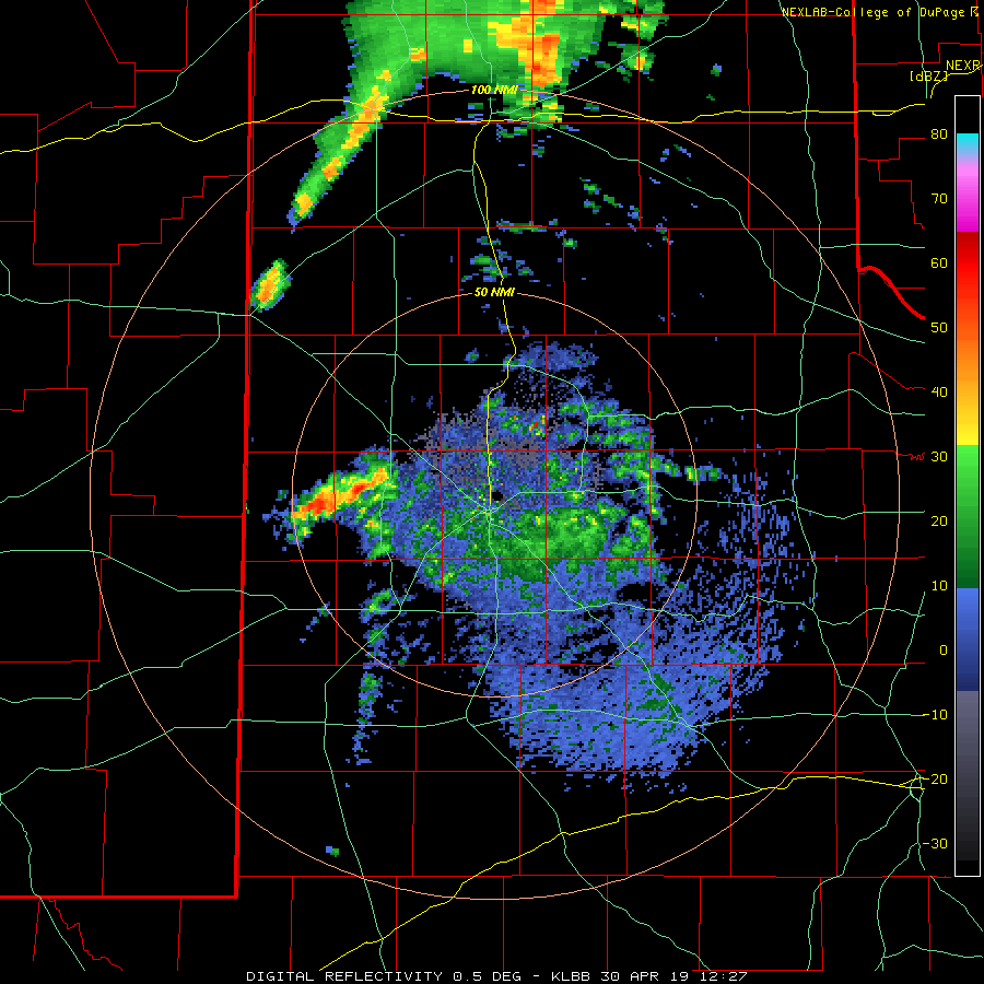
Late April and early May 2019 brought a few rounds of severe weather to West Texas. The activity was triggered by daytime heating along with a couple of passing cold fronts and upper air disturbances, while being fueled by good amounts of moisture and instability. The initial round of severe weather was sparked by a cold front dropping through the South Plains on Saturday, 27 April.
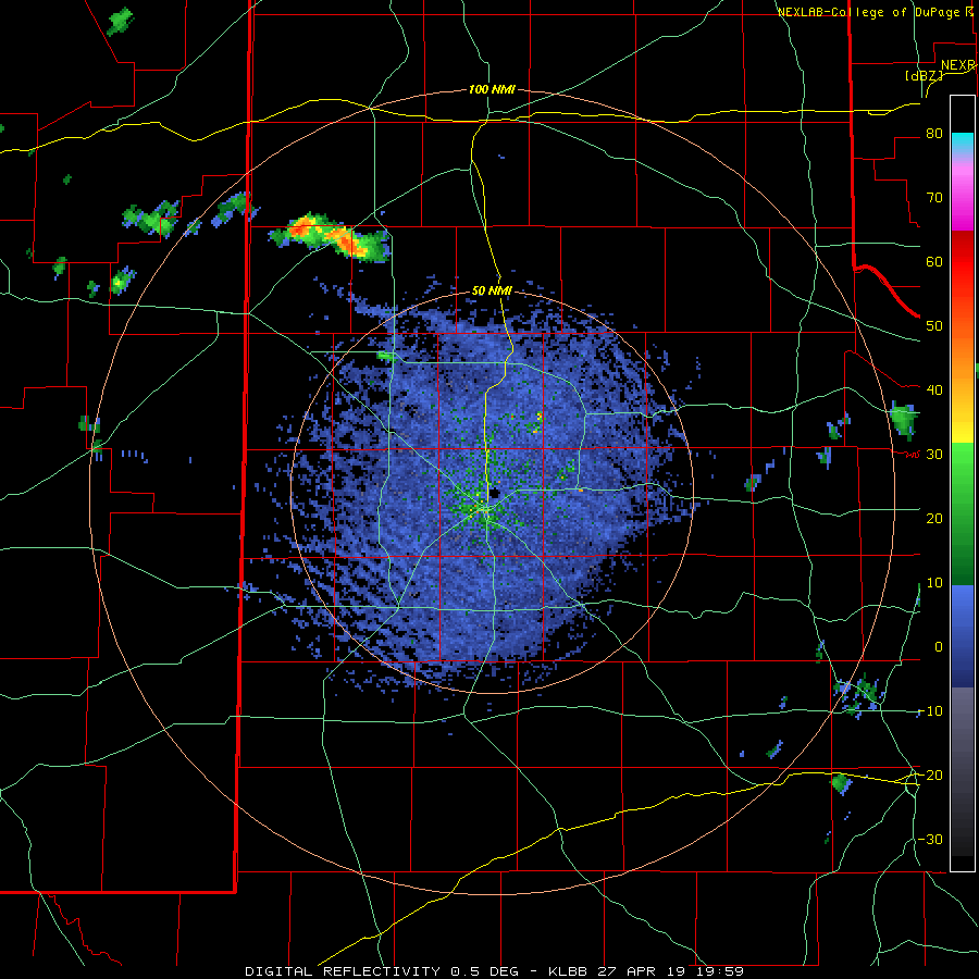
Lubbock radar animation valid from 2:59 pm to 4:39 pm on 27 April 2019.
Scattered thunderstorms developed along and immediately behind the cold front Saturday afternoon. The strongest storms dropped large hail and heavy rain as they moved eastward across the Rolling Plains through the evening hours. Hail as large as baseball size was observed near Jayton as well as west of Swenson, where a car had its windshield broken. The Jayton West Texas Mesonet also recorded a wind gust to 63 mph.
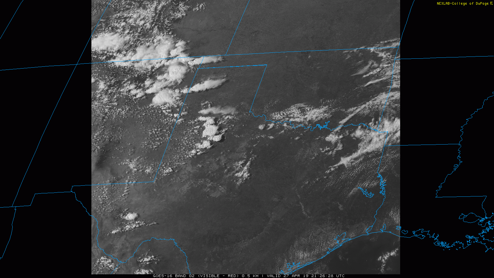
GOES 16 visible satellite loop valid from 4:26 pm to 4:37 pm on 27 April 2019.
As the storms merged into one larger complex in the southern Rolling Plains, one tornado (pictured at the top of this page) briefly touched down between Jayton and Aspermont (just west of Peacock). Thankfully, the tornado was over rural land and did no known damage before dissipating.
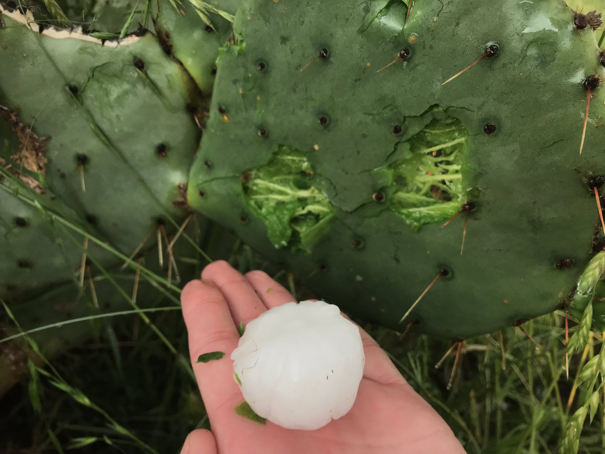
Below are a couple of pictures showing the impressive storm development, as well as the damage that the hail inflicted on the flora of the Rolling Plains.
Left - View of a rapidly developing storm east of Lubbock on Saturday afternoon (27 April 2019). Right - A picture of hail and a damaged cactus about 10 miles southeast of Aspermont on 27 April (picture courtesy of Michael Charnick).
The more intense activity did also drop heavy rain, with the highest rainfall totals falling in a swath from near Spur down to around Aspermont. This quick shot of rain did cause some minor flooding problems in and around Spur.
24-hour radar-estimated and bias-corrected rainfall totals ending at noon on 28 April 2019. The rain totals measured by the West Texas Mesonet sites can also be SEEN HERE.
After a couple of quiet weather days, the weather turned more active again Tuesday afternoon and evening (30 April). This activity was sparked by a lifting warm front and approaching dryline and upper level trough.
View of storms over Motley County (from Lockney) on Tuesday evening (30 April 2019). The picture is courtesy of KAMC.
Widely scattered thunderstorms developed along the warm front sitting across the southern Rolling Plains during the afternoon, while additional activity fired along the dryline across the western South Plains. All of this activity moved eastward through the late afternoon and evening hours. A couple of these storms did acquire mid-level rotation, which helped to increase their intensity and generate large hail.
GOES 16 infrared satellite loop valid from 4:05 pm to 4:16 pm on 30 April 2019.
Hail as large as golf balls was observed south of Jayton, west of Littlefield and near Cotton Center. Even larger hail, measured as big as 2.1" diameter, was measured near Aiken, not far from Plainview.
Hail that fell east of Plainview on Tuesday evening (April 30, 2019). The picture is courtesy of David Garcia.
Below are a couple of different views of the severe thunderstorms that tracked across the South Plains and Rolling Plains Tuesday afternoon and evening.
Several views of storms Tuesday evening (30 April 2019). The left view is from Plainview (courtesy of Storm Search 7) and the right is from Lake Alan Henry (courtesy of KAMC).
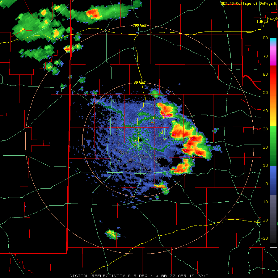
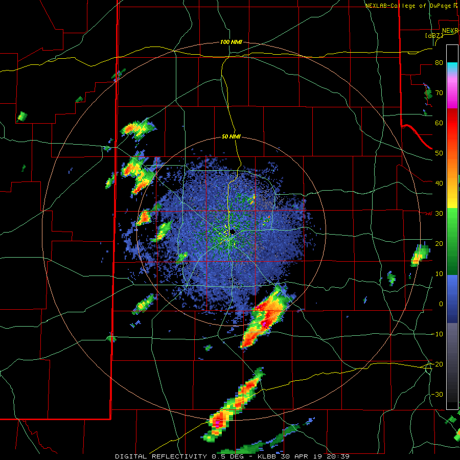
The below radar imagery shows the two most intense storms of the day clearly. The first was the storm that formed near the warm front and tracked across southern portions of Garza, Kent and Stonewall Counties. The other long-duration supercell was a storm that developed west of Littlefield and then tracked steadily eastward through the late afternoon and evening hours, eventually affecting locations between Childress and Paducah.
Lubbock radar animation valid from 3:39 pm to 7:11 pm on 30 April 2019.
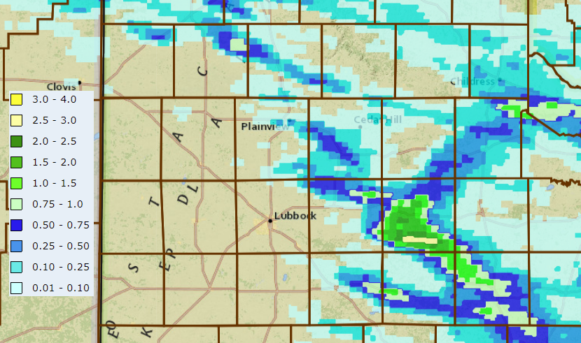
Tuesday's round of thunderstorms brought additional swaths of heavy rainfall to the region. As one might expect, the highest rain totals, near and above an inch, were associated with the two strongest storms of the day. Even outside of the thunderstorms, many locations did receive light rain totals thanks to early day drizzle, showers and thunderstorms. In fact, one early morning storm briefly became severe as it lifted into the south-central Texas Panhandle. A radar animation of the early day activity, valid from 7:27 am to 9:10 am, can be FOUND HERE.
24-hour radar-estimated and bias-corrected rainfall totals ending at 8 am on 1 May 2019.
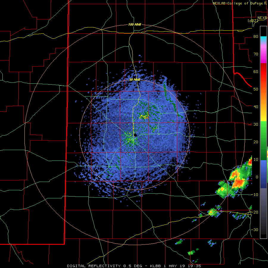
The following day (Wednesday, 1 May 2019) the main action area shifted eastward, with the southern Rolling Plains on the western edge of the thunderstorm activity. Storms exploded along a lingering frontal boundary that clipped southern Stonewall County early Wednesday afternoon. Very strong instability supported quick intensification and a fast transition to supercell thunderstorms.
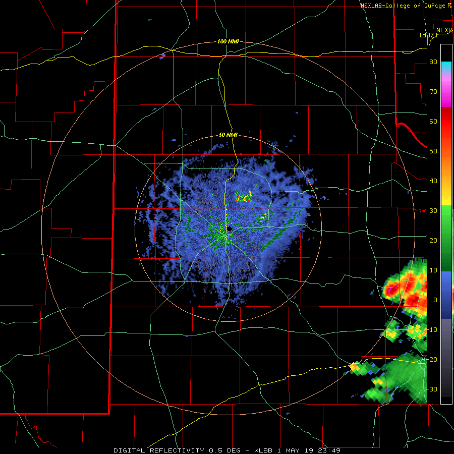
Lubbock radar animation valid from 2:35 pm to 4:40 pm on 1 May 2019. An additional radar animation, valid from 6:49 pm to 9:27 pm can be VIEWED HERE.
Very large hail likely fell with the most intense storms over rural parts of Stonewall County, though we only received verification of golf ball size hail east of Aspermont. In addition, one rotating storm did produce a low-hanging wall cloud as it moved just east of Aspermont, though no known tornado. However, a couple of tornadoes were reported not too far away, one southeast of Haskell and a second north of Throckmorton.
Wall cloud viewed east of Aspermont around 4 pm on 1 May 2019. The picture is courtesy of Joe Ponce.
Even as the storm intensity eased through the evening hours, thunderstorms continued to regenerate over portions of Stonewall County, producing rounds of heavy rain there. A couple of inches or more rain fell over the southeast corner of Stonewall County generally near and south of Old Glory, creating flooding concerns there.
24-hour radar-estimated and bias-corrected rainfall totals ending at noon on 7 am on 2 May 2019. The rain totals measured by the West Texas Mesonet sites can also be SEEN HERE.
A list of the preliminary storm reports for April 27th and 30th can be viewed below.
PRELIMINARY LOCAL STORM REPORT...SUMMARY
NATIONAL WEATHER SERVICE LUBBOCK TX
1034 PM CDT SAT APR 27 2019

..TIME...   ...EVENT...      ...CITY LOCATION...     ...LAT.LON...
..DATE...   ....MAG....      ..COUNTY LOCATION..ST.. ...SOURCE....
            ..REMARKS..

0240 AM     NON-TSTM WND GST 8 WSW SUNDOWN           33.39N 102.61W
04/27/2019  M65 MPH          COCHRAN            TX   MESONET

            WEST TEXAS MESONET REPORT

0505 PM     HAIL             FLOYDADA                33.98N 101.34W
04/27/2019  E1.50 INCH       FLOYD              TX   LAW ENFORCEMENT

            HAIL WAS JUST STARTING.

0510 PM     HAIL             7 W DICKENS             33.62N 100.95W
04/27/2019  E1.25 INCH       DICKENS            TX   TRAINED SPOTTER

            TRAINED STORM SPOTTER REPORTED VIA TWITTER BOTH QUARTER
            AND HALF-DOLLAR SIZED HAIL

0512 PM     HAIL             FLOYDADA                33.98N 101.34W
04/27/2019  E1.00 INCH       FLOYD              TX   CO-OP OBSERVER

            HAIL WAS ENDING. LOTS OF HAIL UP TO 1" DIAMETER. WINDS
            GUSTING 40-50MPH.

0518 PM     HAIL             5 W SPUR                33.48N 100.94W
04/27/2019  E1.25 INCH       DICKENS            TX   TRAINED SPOTTER

0613 PM     FLOOD            SPUR                    33.48N 100.85W
04/27/2019                   DICKENS            TX   TRAINED SPOTTER

            TRAINED SPOTTER REPORTS MAIN ROAD THROUGH SPUR PASSABLE
            BUT SIDE ROADS HAVE 1-1.5FT OF SLOW RUNNING WATER. THOSE
            ARE NOT PASSABLE ATTM.

0625 PM     HAIL             6 SE SPUR               33.42N 100.78W
04/27/2019  M1.00 INCH       DICKENS            TX   TRAINED SPOTTER

            HAIL FALLING AT TIME OF REPORT

0630 PM     TSTM WND GST     1 SSE JAYTON            33.23N 100.57W
04/27/2019  M63 MPH          KENT               TX   MESONET

0645 PM     HAIL             2 SE JAYTON             33.23N 100.55W
04/27/2019  E2.75 INCH       KENT               TX   TRAINED SPOTTER

0654 PM     HAIL             2 N PEACOCK             33.21N 100.40W
04/27/2019  E1.50 INCH       STONEWALL          TX   TRAINED SPOTTER

            TRAINED SPOTTER FOUND THE HAIL ON THE GROUND AFTER
            STORM PASSED

0657 PM     TORNADO          3 W PEACOCK             33.18N 100.45W
04/27/2019                   STONEWALL          TX   TRAINED SPOTTER

            ESTIMATED LOCATION

0703 PM     HAIL             5 W SWENSON             33.21N 100.40W
04/27/2019  E2.75 INCH       STONEWALL          TX   LAW ENFORCEMENT

            HAIL BROKE OUT WINDSHIELD OF SHERIFF CAR

0709 PM     HAIL             1 N PEACOCK             33.20N 100.40W
04/27/2019  M2.00 INCH       STONEWALL          TX   TRAINED SPOTTER

0711 PM     HAIL             ASPERMONT               33.14N 100.22W
04/27/2019  E1.25 INCH       STONEWALL          TX   CO-OP OBSERVER

            HAIL WAS GETTING LARGER BUT OBSERVER NEEDED TO GO TAKE
            SHELTER FROM POSSIBLE TORNADO

0715 PM     HAIL             ASPERMONT               33.14N 100.22W
04/27/2019  M1.50 INCH       STONEWALL          TX   TRAINED SPOTTER

0725 PM     HAIL             2 E ASPERMONT           33.14N 100.19W
04/27/2019  E1.00 INCH       STONEWALL          TX   TRAINED SPOTTER

            FALLING NOW, WIND DRIVEN HAIL
Preliminary Storm Report for 30 April 2019
PRELIMINARY LOCAL STORM REPORT...SUMMARY
NATIONAL WEATHER SERVICE LUBBOCK TX
1013 PM CDT TUE APR 30 2019

..TIME...   ...EVENT...      ...CITY LOCATION...     ...LAT.LON...
..DATE...   ....MAG....      ..COUNTY LOCATION..ST.. ...SOURCE....
            ..REMARKS..

0428 PM     HAIL             9 W LITTLEFIELD         33.92N 102.49W
04/30/2019  E1.75 INCH       LAMB               TX   LAW ENFORCEMENT

0520 PM     HAIL             10 S JAYTON             33.11N 100.57W
04/30/2019  E1.75 INCH       KENT               TX   LAW ENFORCEMENT

            REPORTED ALONG STATE HIGHWAY 70 SOUTH OF JAYTON.

0530 PM     HAIL             1 E COTTON CENTER       33.99N 101.97W
04/30/2019  E1.75 INCH       HALE               TX   BROADCAST MEDIA

0545 PM     HAIL             1 E HALE CENTER         34.06N 101.83W
04/30/2019  E1.00 INCH       HALE               TX   STORM CHASER

0615 PM     HAIL             5 SW AIKEN              34.09N 101.59W
04/30/2019  E2.10 INCH       HALE               TX   PUBLIC

0638 PM     HAIL             LOCKNEY                 34.12N 101.44W
04/30/2019  E0.75 INCH       FLOYD              TX   BROADCAST MEDIA
Local Storm Report 3/13/2019
PRELIMINARY LOCAL STORM REPORT...SUMMARY RETRANSMITTED
NATIONAL WEATHER SERVICE LUBBOCK TX
951 PM CDT WED MAR 13 2019

..TIME...   ...EVENT...      ...CITY LOCATION...     ...LAT.LON...
..DATE...   ....MAG....      ..COUNTY LOCATION..ST.. ...SOURCE....
            ..REMARKS..

1245 AM     TSTM WND GST     10 WSW GUTHRIE          33.57N 100.48W
03/13/2019  M60 MPH          KING               TX   MESONET

            WEST TEXAS MESONET

1000 AM     NON-TSTM WND DMG 1 S JAYTON              33.24N 100.57W
03/13/2019                   KENT               TX   LAW ENFORCEMENT

            TRUCK-TRACTOR SEMI OVERTURNED BY WINDS. MULTIPLE
            UNRELATED POWER OUTAGES.

1148 AM     NON-TSTM WND DMG LUBBOCK                 33.58N 101.88W
03/13/2019                   LUBBOCK            TX   EMERGENCY MNGR

            MULTIPLE DOWNED UTILITY POLES ACROSS THE CITY.

1215 PM     NON-TSTM WND GST 1 S PLAINVIEW           34.16N 101.72W
03/13/2019  M62 MPH          HALE               TX   AWOS

1240 PM     NON-TSTM WND GST 6 SSW ANTON             33.73N 102.19W
03/13/2019  M72 MPH          HOCKLEY            TX   MESONET

            WEST TEXAS MESONET

0102 PM     NON-TSTM WND GST CAPROCK CANYON SP       34.41N 101.06W
03/13/2019  M70 MPH          BRISCOE            TX   MESONET

            WEST TEXAS MESONET

0122 PM     NON-TSTM WND DMG DICKENS                 33.62N 100.84W
03/13/2019                   DICKENS            TX   LAW ENFORCEMENT

            1 ABANDONED BUILDING WITH 2 COLLAPSED WALLS AND ANOTHER
            ABANDONED BUILDING WITH THE ROOF PEELING OFF.

0125 PM     NON-TSTM WND GST 3 N PLAINS              33.23N 102.84W
03/13/2019  M65 MPH          YOAKUM             TX   MESONET

            WEST TEXAS MESONET

0140 PM     NON-TSTM WND GST 2 NNE CHILDRESS         34.46N 100.20W
03/13/2019  M60 MPH          CHILDRESS          TX   MESONET

            WEST TEXAS MESONET

0145 PM     NON-TSTM WND GST 2 NE FRIONA             34.65N 102.69W
03/13/2019  M73 MPH          PARMER             TX   MESONET

            WEST TEXAS MESONET

0150 PM     NON-TSTM WND GST 10 WSW GUTHRIE          33.57N 100.48W
03/13/2019  M65 MPH          KING               TX   MESONET

            WEST TEXAS MESONET

0158 PM     NON-TSTM WND GST 4 SSW LUBBOCK           33.53N 101.88W
03/13/2019  M68 MPH          LUBBOCK            TX   NWS OFFICE

0210 PM     NON-TSTM WND GST 2 WSW TURKEY            34.38N 100.93W
03/13/2019  M70 MPH          HALL               TX   MESONET

            WEST TEXAS MESONET

0210 PM     NON-TSTM WND GST 2 WSW TURKEY            34.38N 100.93W
03/13/2019  M70 MPH          HALL               TX   MESONET

0210 PM     NON-TSTM WND GST 5 SSW GRAHAM            33.08N 101.50W
03/13/2019  M62 MPH          GARZA              TX   MESONET

0215 PM     NON-TSTM WND GST 3 N ROARING SPRINGS     33.94N 100.85W
03/13/2019  M69 MPH          MOTLEY             TX   MESONET

            WEST TEXAS MESONET

0215 PM     NON-TSTM WND GST 4 S LEVELLAND           33.53N 102.36W
03/13/2019  M66 MPH          HOCKLEY            TX   MESONET

            WEST TEXAS MESONET

0215 PM     NON-TSTM WND GST 5 ENE ABERNATHY         33.88N 101.76W
03/13/2019  M64 MPH          HALE               TX   MESONET

            WEST TEXAS MESONET

0221 PM     NON-TSTM WND GST 3 SSE ESTELLINE         34.50N 100.42W
03/13/2019  M63 MPH          HALL               TX   MESONET

            WEST TEXAS MESONET

0230 PM     NON-TSTM WND DMG 13 NW CHILDRESS         34.56N 100.41W
03/13/2019                   CHILDRESS          TX   EMERGENCY MNGR

            SEMI-TRUCK BLOWN OVER IN THE NORTH-BOUND LANES OF US
            287 0.5 MILES EAST OF THE HALL COUNTY BORDER.

0230 PM     NON-TSTM WND GST 6 SSW WOLFFORTH         33.42N 102.05W
03/13/2019  M63 MPH          LUBBOCK            TX   MESONET

            WEST TEXAS MESONET

0230 PM     NON-TSTM WND GST 3 WNW LUBBOCK           33.60N 101.90W
03/13/2019  M61 MPH          LUBBOCK            TX   MESONET

            WEST TEXAS MESONET

0230 PM     NON-TSTM WND DMG CHILDRESS               34.42N 100.25W
03/13/2019                   CHILDRESS          TX   EMERGENCY MNGR

            CATTLE TRUCK BLOWN OVER NEAR THE INTERSECTION OF LOOP 9
            AND US 287 NORTHWEST OF CHILDRESS. LOCATION ESTIMATED AS
            INITIAL REPORT INDICATED LOOP 328 AND US 287 WHICH
            DOESNT APPEAR TO EXIST.

0240 PM     NON-TSTM WND GST 1 NW LAKE ALAN HENRY    33.07N 101.06W
03/13/2019  M60 MPH          GARZA              TX   MESONET

0245 PM     NON-TSTM WND GST 1 S NORTHFIELD          34.27N 100.60W
03/13/2019  M64 MPH          MOTLEY             TX   MESONET

            WEST TEXAS MESONET

0250 PM     NON-TSTM WND GST 6 S OLTON               34.09N 102.12W
03/13/2019  M65 MPH          LAMB               TX   MESONET

            WEST TEXAS MESONET

0255 PM     NON-TSTM WND GST 8 WSW SUNDOWN           33.39N 102.61W
03/13/2019  M65 MPH          COCHRAN            TX   MESONET

            WEST TEXAS MESONET

0300 PM     NON-TSTM WND GST 2 NE DIMMITT            34.57N 102.29W
03/13/2019  M74 MPH          CASTRO             TX   MESONET

            WEST TEXAS MESONET

0300 PM     NON-TSTM WND GST 1 ENE MORTON            33.73N 102.74W
03/13/2019  M70 MPH          COCHRAN            TX   MESONET

            WEST TEXAS MESONET

0300 PM     NON-TSTM WND DMG POST                    33.19N 101.38W
03/13/2019                   GARZA              TX   SOCIAL MEDIA

            CONVENIENCE STORE SIGN DESTROYED

0305 PM     NON-TSTM WND GST 2 S BROWNFIELD          33.15N 102.27W
03/13/2019  M64 MPH          TERRY              TX   MESONET

            WEST TEXAS MESONET

0305 PM     NON-TSTM WND GST 1 NE MEMPHIS            34.73N 100.53W
03/13/2019  M59 MPH          HALL               TX   MESONET

0310 PM     NON-TSTM WND GST 1 SE RALLS              33.67N 101.38W
03/13/2019  M66 MPH          CROSBY             TX   MESONET

            WEST TEXAS MESONET

0310 PM     NON-TSTM WND GST 6 NW WHITE RIVER LAKE   33.53N 101.17W
03/13/2019  M64 MPH          CROSBY             TX   MESONET

            WEST TEXAS MESONET

0310 PM     NON-TSTM WND GST 1 NE POST               33.20N 101.37W
03/13/2019  M67 MPH          GARZA              TX   MESONET

            WEST TEXAS MESONET

0310 PM     NON-TSTM WND GST REESE CENTER            33.61N 102.05W
03/13/2019  M66 MPH          LUBBOCK            TX   MESONET

            WEST TEXAS MESONET

0312 PM     NON-TSTM WND GST 2 SSE HACKBERRY         33.90N 100.13W
03/13/2019  M66 MPH          COTTLE             TX   MESONET

            WEST TEXAS MESONET

0317 PM     NON-TSTM WND GST NEW HOME                33.33N 101.91W
03/13/2019  M67 MPH          LYNN               TX   MESONET

            WEST TEXAS MESONET

0325 PM     NON-TSTM WND GST 2 SSW MULESHOE          34.21N 102.74W
03/13/2019  M67 MPH          BAILEY             TX   MESONET

            WEST TEXAS MESONET

0326 PM     NON-TSTM WND GST 2 S LESLEY              34.65N 100.81W
03/13/2019  M66 MPH          HALL               TX   MESONET

            WEST TEXAS MESONET

0329 PM     NON-TSTM WND GST 6 NNE LUBBOCK           33.67N 101.82W
03/13/2019  M67 MPH          LUBBOCK            TX   ASOS

0329 PM     NON-TSTM WND GST 3 NNE TAHOKA            33.21N 101.78W
03/13/2019  M62 MPH          LYNN               TX   MESONET

            WEST TEXAS MESONET

0335 PM     NON-TSTM WND GST 2 NE SLATON             33.46N 101.62W
03/13/2019  M64 MPH          LUBBOCK            TX   MESONET

            WEST TEXAS MESONET

0335 PM     NON-TSTM WND GST 2 NNE FLOYDADA          34.00N 101.33W
03/13/2019  M64 MPH          FLOYD              TX   MESONET

            WEST TEXAS MESONET

0340 PM     NON-TSTM WND GST 1 S PLAINVIEW           34.18N 101.71W
03/13/2019  M64 MPH          HALE               TX   MESONET

            WEST TEXAS MESONET

0340 PM     NON-TSTM WND GST 1 S PLAINVIEW           34.18N 101.72W
03/13/2019  M64 MPH          HALE               TX   MESONET

0350 PM     NON-TSTM WND GST 7 ESE SILVERTON         34.45N 101.19W
03/13/2019  M67 MPH          BRISCOE            TX   MESONET

            WEST TEXAS MESONET

0359 PM     NON-TSTM WND GST 3 ENE SOUTH PLAINS      34.24N 101.26W
03/13/2019  M63 MPH          FLOYD              TX   MESONET

            WEST TEXAS MESONET

0405 PM     NON-TSTM WND GST 3 N HART                34.42N 102.11W
03/13/2019  M68 MPH          CASTRO             TX   MESONET

            WEST TEXAS MESONET

0415 PM     NON-TSTM WND GST 2 ENE TULIA             34.54N 101.74W
03/13/2019  M74 MPH          SWISHER            TX   MESONET

            WEST TEXAS MESONET

0423 PM     NON-TSTM WND GST 3 WSW AIKEN             34.13N 101.57W
03/13/2019  M66 MPH          HALE               TX   MESONET

            WEST TEXAS MESONET

0445 PM     NON-TSTM WND GST VIGO PARK               34.65N 101.50W
03/13/2019  M74 MPH          SWISHER            TX   MESONET

            WEST TEXAS MESONET

0450 PM     NON-TSTM WND GST 1 NE AMHERST            34.02N 102.40W
03/13/2019  M65 MPH          LAMB               TX   MESONET

            WEST TEXAS MESONET

0459 PM     NON-TSTM WND GST 9 WSW EARTH             34.19N 102.56W
03/13/2019  M68 MPH          LAMB               TX   MESONET

            WEST TEXAS MESONET

0500 PM     NON-TSTM WND GST HAPPY                   34.74N 101.84W
03/13/2019  M73 MPH          SWISHER            TX   MESONET

            WEST TEXAS MESONET

0510 PM     NON-TSTM WND GST 1 N O`DONNELL           32.98N 101.83W
03/13/2019  M62 MPH          LYNN               TX   MESONET

            WEST TEXAS MESONET

0833 PM     NON-TSTM WND GST 7 WNW DENVER CITY       33.01N 102.94W
03/13/2019  M68 MPH          YOAKUM             TX   MESONET

0921 PM     NON-TSTM WND GST 10 SW PADUCAH           33.91N 100.43W
03/13/2019  M62 MPH          COTTLE             TX   MESONET


&&

EVENT NUMBER LUB1900121 LUB1900171 LUB1900146 LUB1900158 LUB1900142
LUB1900123 LUB1900167 LUB1900139 LUB1900166 LUB1900126 LUB1900141
LUB1900169 LUB1900130 LUB1900173 LUB1900174 LUB1900147 LUB1900152
LUB1900157 LUB1900168 LUB1900138 LUB1900151 LUB1900156 LUB1900175
LUB1900176 LUB1900162 LUB1900131 LUB1900145 LUB1900133 LUB1900150
LUB1900172 LUB1900163 LUB1900170 LUB1900124 LUB1900143 LUB1900144
LUB1900148 LUB1900137 LUB1900136 LUB1900135 LUB1900154 LUB1900153
LUB1900159 LUB1900140 LUB1900155 LUB1900161 LUB1900179 LUB1900125
LUB1900164 LUB1900149 LUB1900160 LUB1900128 LUB1900134 LUB1900165
LUB1900127 LUB1900129 LUB1900132 LUB1900178 LUB1900177


$$

MCQUEEN


