
A robust upper level storm system emerging from the Four Corners region delivered another Windy Wednesday to the South Plains on April 10th. This system, similar to the one that impacted West Texas about a month earlier, brought widespread severe wind gusts across the South Plains and southern Texas Panhandle Wednesday afternoon and evening. However, unlike the March system, this one was not preceded by a round of thunderstorms.
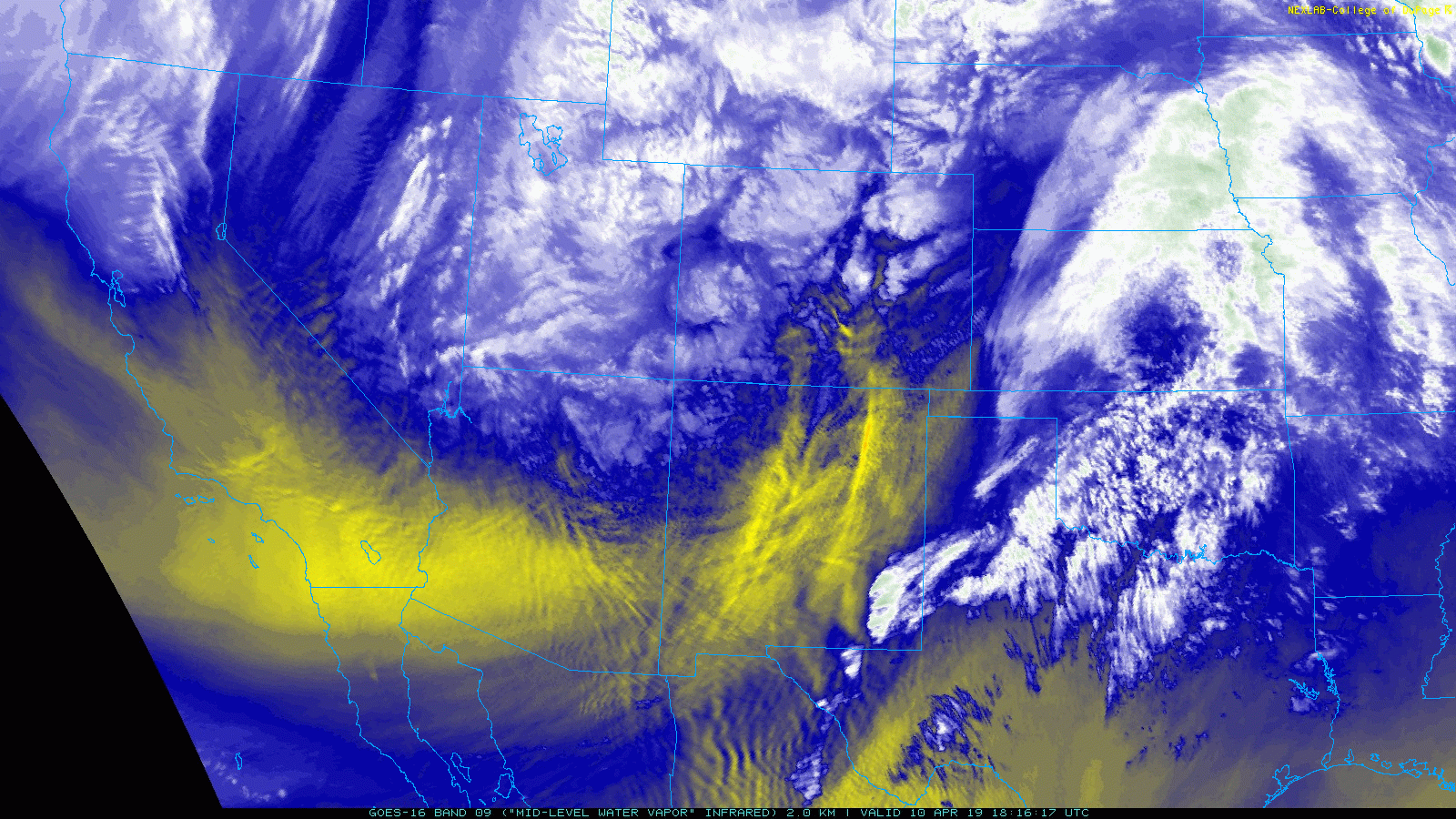
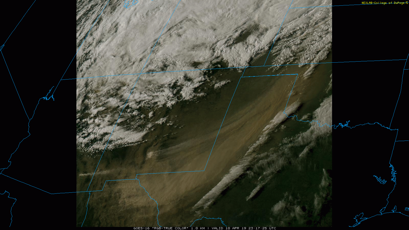
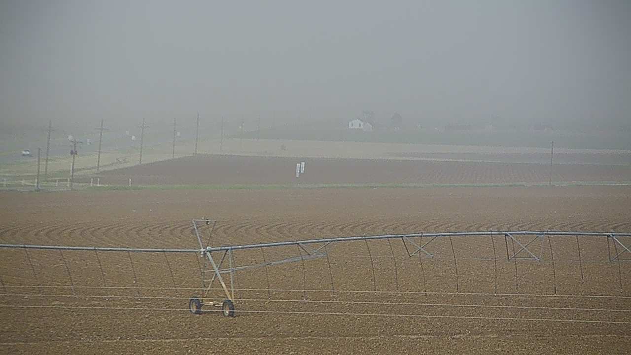
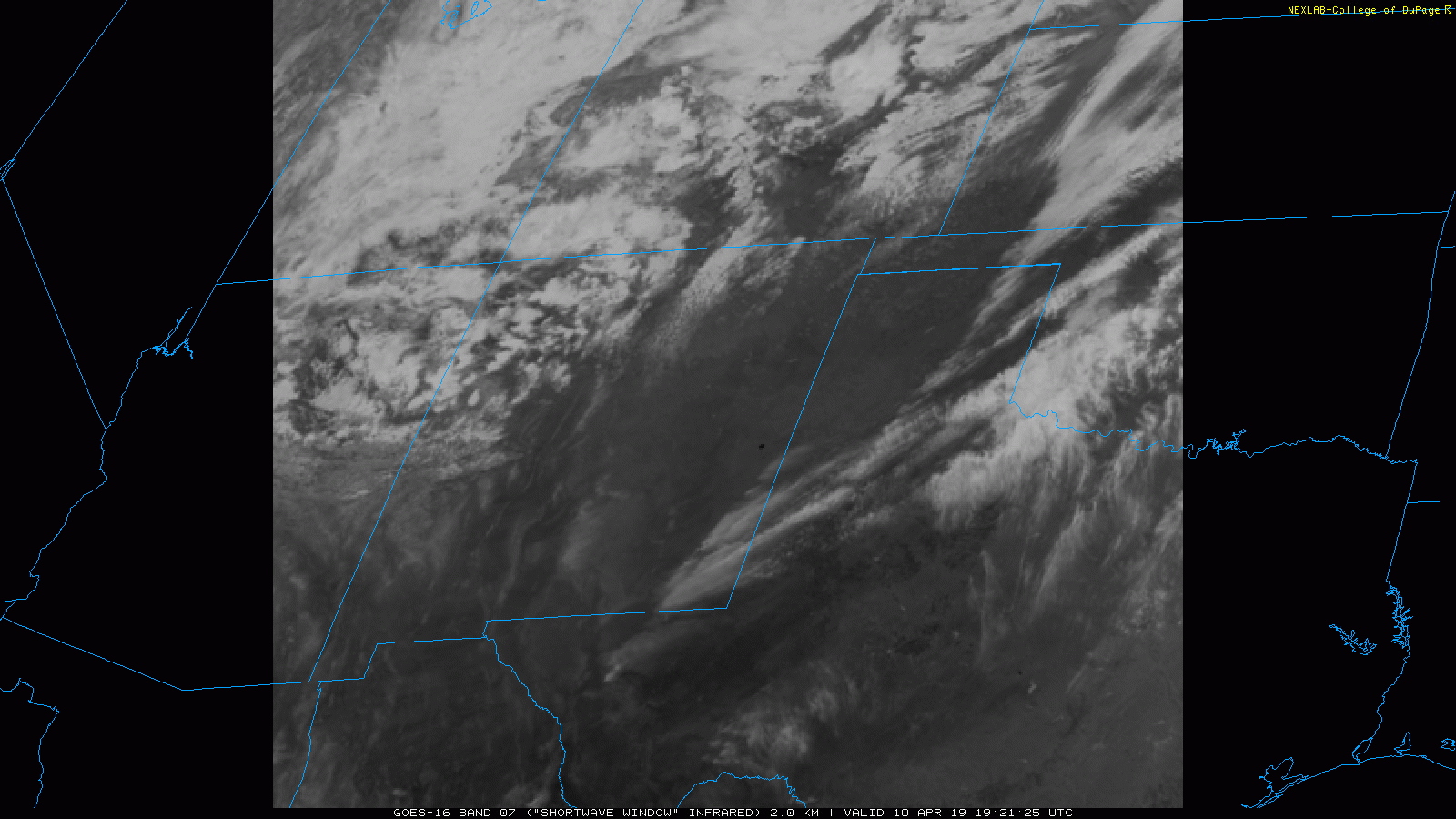
The first half of the day wasn't too bad, but as the system drew closer the winds increased markedly during the afternoon. The strong winds lofted copious amounts of dust from northern Mexico, southern New Mexico and much of West Texas and carried it off to the northeast. The below satellite imagery clearly shows a thick plume of dust, including a fetch off White Sands National Monument, being ingested into the storm system as it lifted into the Central Plains. Impressively, some of this dust made it all the way into the Upper Midwest where it fell as a "dirty" snow.
The dust was thick enough that it could even be picked up by area radars in spots, as seen below, while the nearest precipitation stayed well to the north in northern New Mexico, Colorado and Kansas.

The below images show the dusty scene that enveloped the region. The visibility did drop to near zero in favored spots downwind of open fields. Unfortunately, the low visibility contributed to several auto accidents Wednesday afternoon and evening.
 |
 |
The warm, dry and very windy conditions did also support a few wildfires in the region. A "hotspot" (dark black pixels), indicative of an ongoing wildfire, is seen in east-central New Mexico in the below satellite loop. Thankfully, most of the fires were relatively short-lived and did little to no damage.
The plot below shows the strongest wind gusts measured by the West Texas Mesonet on April 10th. Peak wind gusts of 60 to 65 mph were common across the Caprock with one gust as high as 73 mph measured near Anton. Officially the Lubbock Airport measured a peak gust of 62 mph.

The intense winds did knock down power lines around 7th Street and Broadway in Lubbock. A more complete listing of the preliminary storm reports for the Windy Wednesday can be viewed below.
PRELIMINARY LOCAL STORM REPORT...SUMMARY
NATIONAL WEATHER SERVICE LUBBOCK TX
1013 PM CDT WED APR 10 2019

..TIME...   ...EVENT...      ...CITY LOCATION...     ...LAT.LON...
..DATE...   ....MAG....      ..COUNTY LOCATION..ST.. ...SOURCE....
            ..REMARKS..

0140 PM     NON-TSTM WND GST 2 SSW MULESHOE          34.21N 102.74W
04/10/2019  M59 MPH          BAILEY             TX   MESONET

0201 PM     NON-TSTM WND GST HAPPY                   34.74N 101.84W
04/10/2019  M60 MPH          SWISHER            TX   MESONET

0201 PM     NON-TSTM WND GST HAPPY                   34.74N 101.84W
04/10/2019  M60 MPH          SWISHER            TX   MESONET

0210 PM     NON-TSTM WND GST 2 NE FRIONA             34.65N 102.69W
04/10/2019  M60 MPH          PARMER             TX   MESONET

0210 PM     NON-TSTM WND GST VIGO PARK               34.65N 101.50W
04/10/2019  M59 MPH          SWISHER            TX   MESONET

0210 PM     NON-TSTM WND GST 6 S OLTON               34.09N 102.12W
04/10/2019  M58 MPH          LAMB               TX   MESONET

0225 PM     NON-TSTM WND GST 6 SSW ANTON             33.73N 102.19W
04/10/2019  M60 MPH          HOCKLEY            TX   MESONET

0245 PM     NON-TSTM WND GST 2 NE DIMMITT            34.57N 102.29W
04/10/2019  M58 MPH          CASTRO             TX   MESONET

0248 PM     NON-TSTM WND GST VIGO PARK               34.65N 101.50W
04/10/2019  M61 MPH          SWISHER            TX   MESONET

0300 PM     NON-TSTM WND GST 1 ENE MORTON            33.73N 102.74W
04/10/2019  M64 MPH          COCHRAN            TX   MESONET

0300 PM     NON-TSTM WND GST 1 S PLAINVIEW           34.18N 101.71W
04/10/2019  M59 MPH          HALE               TX   MESONET

0305 PM     NON-TSTM WND GST ANTON                   33.81N 102.16W
04/10/2019  M61 MPH          HOCKLEY            TX   MESONET

0329 PM     NON-TSTM WND GST NEW HOME                33.33N 101.91W
04/10/2019  M58 MPH          LYNN               TX   MESONET

0335 PM     NON-TSTM WND GST 1 NE AMHERST            34.02N 102.40W
04/10/2019  M59 MPH          LAMB               TX   MESONET

0341 PM     NON-TSTM WND GST HAPPY                   34.74N 101.84W
04/10/2019  M58 MPH          SWISHER            TX   MESONET

0345 PM     NON-TSTM WND GST 8 WSW SUNDOWN           33.39N 102.61W
04/10/2019  M58 MPH          COCHRAN            TX   MESONET

0345 PM     NON-TSTM WND GST 3 N PLAINS              33.23N 102.84W
04/10/2019  M61 MPH          YOAKUM             TX   MESONET

0347 PM     NON-TSTM WND GST 3 WSW AIKEN             34.13N 101.57W
04/10/2019  M61 MPH          HALE               TX   MESONET

0400 PM     NON-TSTM WND GST REESE CENTER            33.61N 102.05W
04/10/2019  M61 MPH          LUBBOCK            TX   MESONET

0400 PM     NON-TSTM WND GST 2 WSW TURKEY            34.38N 100.93W
04/10/2019  M61 MPH          HALL               TX   MESONET

0400 PM     NON-TSTM WND GST 7 ESE SILVERTON         34.45N 101.19W
04/10/2019  M58 MPH          BRISCOE            TX   MESONET

0404 PM     NON-TSTM WND GST 9 WSW EARTH             34.19N 102.56W
04/10/2019  M61 MPH          LAMB               TX   MESONET

0405 PM     NON-TSTM WND GST 2 NE FRIONA             34.65N 102.69W
04/10/2019  M62 MPH          PARMER             TX   MESONET

0435 PM     NON-TSTM WND GST 3 N HART                34.42N 102.11W
04/10/2019  M64 MPH          CASTRO             TX   MESONET

0440 PM     NON-TSTM WND GST 4 S LEVELLAND           33.53N 102.36W
04/10/2019  M63 MPH          HOCKLEY            TX   MESONET

0450 PM     NON-TSTM WND GST 7 WNW DENVER CITY       32.99N 102.94W
04/10/2019  M59 MPH          YOAKUM             TX   MESONET

0455 PM     NON-TSTM WND GST 5 ENE ABERNATHY         33.88N 101.76W
04/10/2019  M59 MPH          HALE               TX   MESONET

0455 PM     NON-TSTM WND GST 3 N PLAINS              33.23N 102.84W
04/10/2019  M69 MPH          YOAKUM             TX   MESONET

0455 PM     NON-TSTM WND GST 1 S PLAINVIEW           34.16N 101.72W
04/10/2019  M66 MPH          HALE               TX   AWOS

0510 PM     NON-TSTM WND GST 2 ENE TULIA             34.54N 101.74W
04/10/2019  M58 MPH          SWISHER            TX   MESONET

0510 PM     NON-TSTM WND GST 1 S PLAINVIEW           34.18N 101.71W
04/10/2019  M62 MPH          HALE               TX   MESONET

0520 PM     NON-TSTM WND GST 6 SSW ANTON             33.73N 102.19W
04/10/2019  M70 MPH          HOCKLEY            TX   MESONET

0520 PM     NON-TSTM WND GST 2 S BROWNFIELD          33.15N 102.27W
04/10/2019  M58 MPH          TERRY              TX   MESONET

0520 PM     NON-TSTM WND GST 4 S LEVELLAND           33.53N 102.36W
04/10/2019  M66 MPH          HOCKLEY            TX   MESONET

0520 PM     NON-TSTM WND GST 6 S OLTON               34.09N 102.12W
04/10/2019  M64 MPH          LAMB               TX   MESONET

0525 PM     NON-TSTM WND GST 5 ENE ABERNATHY         33.88N 101.76W
04/10/2019  M69 MPH          HALE               TX   MESONET

0525 PM     NON-TSTM WND GST 2 S LESLEY              34.65N 100.81W
04/10/2019  M58 MPH          HALL               TX   MESONET

0525 PM     NON-TSTM WND GST 2 SSW MULESHOE          34.21N 102.74W
04/10/2019  M64 MPH          BAILEY             TX   MESONET

0525 PM     NON-TSTM WND GST 8 WSW SUNDOWN           33.39N 102.61W
04/10/2019  M66 MPH          COCHRAN            TX   MESONET

0530 PM     NON-TSTM WND GST 1 NE AMHERST            34.02N 102.40W
04/10/2019  M58 MPH          LAMB               TX   MESONET

0530 PM     NON-TSTM WND GST 6 SSW WOLFFORTH         33.42N 102.05W
04/10/2019  M59 MPH          LUBBOCK            TX   MESONET

0530 PM     NON-TSTM WND GST 2 NE DIMMITT            34.57N 102.29W
04/10/2019  M60 MPH          CASTRO             TX   MESONET

0540 PM     NON-TSTM WND GST 3 WSW AIKEN             34.13N 101.57W
04/10/2019  M68 MPH          HALE               TX   MESONET

0540 PM     NON-TSTM WND GST 6 SSW ANTON             33.73N 102.19W
04/10/2019  M73 MPH          HOCKLEY            TX   MESONET

0540 PM     NON-TSTM WND GST REESE CENTER            33.61N 102.05W
04/10/2019  M64 MPH          LUBBOCK            TX   MESONET

0541 PM     NON-TSTM WND DMG LUBBOCK                 33.58N 101.88W
04/10/2019                   LUBBOCK            TX   EMERGENCY MNGR

            REPORT OF POWERLINES DOWN ON CARS ON 7TH AND BROADWAY.

0541 PM     NON-TSTM WND GST 3 ENE SOUTH PLAINS      34.24N 101.26W
04/10/2019  M59 MPH          FLOYD              TX   MESONET

0545 PM     NON-TSTM WND GST 7 ESE SILVERTON         34.45N 101.19W
04/10/2019  M62 MPH          BRISCOE            TX   MESONET

0547 PM     NON-TSTM WND GST CAPROCK CANYON SP       34.41N 101.06W
04/10/2019  M59 MPH          BRISCOE            TX   MESONET

0550 PM     NON-TSTM WND GST 2 NNE FLOYDADA          34.00N 101.33W
04/10/2019  M61 MPH          FLOYD              TX   MESONET

0600 PM     NON-TSTM WND GST 3 ENE SOUTH PLAINS      34.24N 101.26W
04/10/2019  M63 MPH          FLOYD              TX   MESONET

0605 PM     NON-TSTM WND GST 6 SSW WOLFFORTH         33.42N 102.05W
04/10/2019  M61 MPH          LUBBOCK            TX   MESONET

0619 PM     NON-TSTM WND GST CAPROCK CANYON SP       34.41N 101.06W
04/10/2019  M61 MPH          BRISCOE            TX   MESONET

0630 PM     NON-TSTM WND GST 2 WSW TURKEY            34.38N 100.93W
04/10/2019  M62 MPH          HALL               TX   MESONET

0635 PM     NON-TSTM WND GST 4 S LEVELLAND           33.53N 102.36W
04/10/2019  M65 MPH          HOCKLEY            TX   MESONET

0654 PM     NON-TSTM WND GST 6 NNE LUBBOCK           33.67N 101.82W
04/10/2019  M62 MPH          LUBBOCK            TX   ASOS

1043 PM     NON-TSTM WND GST 3 NNE TAHOKA            33.21N 101.78W
04/10/2019  M58 MPH          LYNN               TX   MESONET

1140 PM     NON-TSTM WND GST 2 NE SLATON             33.46N 101.62W
04/10/2019  M58 MPH          LUBBOCK            TX   MESONET

