| First Severe Thunderstorm of 2018 for NWS Lubbock 24 April 2018 |
|
 |
|
| View of thunderstorms just east of Lubbock at 7:07 pm on Tuesday, 24 April 2018. | |
| Just enough moisture and instability was present, when combined with strong daytime heating and a couple of boundaries ahead of an approaching cold front and upper level disturbance, to fuel widely scattered shower and thunderstorm development late Tuesday afternoon (24 April). Although instability was limited, it was sufficient to support a few strong to marginally severe thunderstorms. The strongest storm of the evening briefly became severe across eastern Lubbock County and western Crosby County as it tracked between Ransom Canyon and Idalou then up to near Lorenzo where quarter size hail was observed. Other strong storms likely dropped small hail over portions of the southeast South Plains into the central and southern Rolling Plains during the late afternoon and evening hours before shifting east and diminishing. | |
 |
|
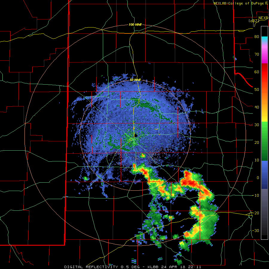
| Lubbock radar animation valid from 5:11 pm to 8:47 pm on 24 April 2018. A regional radar animation valid from 6:28 pm to 7:38 pm on the 24th can be VIEWED HERE. | |
| Although the briefly severe thunderstorm wasn't particularly notable, it was the first severe thunderstorm in NWS Lubbock's County Warning Area in 2018. This is the latest in the year for the first severe thunderstorm warning to be issued for NWS Lubbock during the period from 2001 until 2018. In addition, it was the first thunderstorm warning issued since October 21st of 2017, over half a year ago. This long drought in severe weather may not be too surprising when considering the region hasn't received much precipitation in any form since last fall. | |
 |
|
| Visible satellite image captured at 6:46 pm on 24 April 2018. | |
| The above satellite image and below pictures show a few different views of what the thunderstorms looked like during the evening of the 24th. The bulk of the activity diminish by late evening, though additional showers and isolated thunderstorms did redevelop over portions of the South Plains and Rolling Plains early the next morning. (To view a regional radar animation valid from 4:58 am to 6:08 am on the morning of the 25th CLICK HERE.) The scattered rain early Wednesday occurred as relatively warm and moist air was lifted over cooler air that invaded the region behind a strong cold front Tuesday evening. | |
 |
 |
| A couple of pictures of developing thunderstorms just east of Lubbock Tuesday evening. The storm went on to produce quarter size hail and brief heavy rain. | |
| Rain totals were not very impressive during this event, except in narrow swaths under the strongest thunderstorms where localized 1/4 to 1/2+ inch amounts fell. Unfortunately most spots only received totals from a trace to tenth of an inch. | |
 |
|
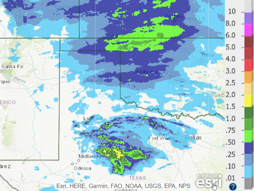
| Radar-estimated and bias-corrected precipitation totals for 24-25 April 2018. A regional view containing the same information can be FOUND HERE. To view a plot of 48 hour rain totals from the West Texas Mesonet ending at 5 am on the 26th CLICK HERE. | |

