National Weather Service Lubbock Significant Weather Events
Dec. 7-8, 2018: Winter storm brings heavy snow to parts of the South Plains
Snow falling in southwest Lubbock on Saturday morning (December 8, 2018). Image courtesy Mark Conder.
A moisture infused storm system brought widespread winter weather to West Texas in early December, including a swath of heavy snow from the South Plains into the Rolling Plains. The winter storm was preceded by a strong cold front that moved through on Thursday, December 6th. Behind the front gusty northerly winds carried in much colder air. Temperatures dropped into the lower and middle 30s by early Friday morning, when the initial effects of the approaching storm were felt. Scattered rain showers developed, with pockets of freezing rain where temperatures were at or slightly below the freezing mark. Thankfully, the marginal temperatures and relatively mild ground kept impacts minimal through the day on Friday.
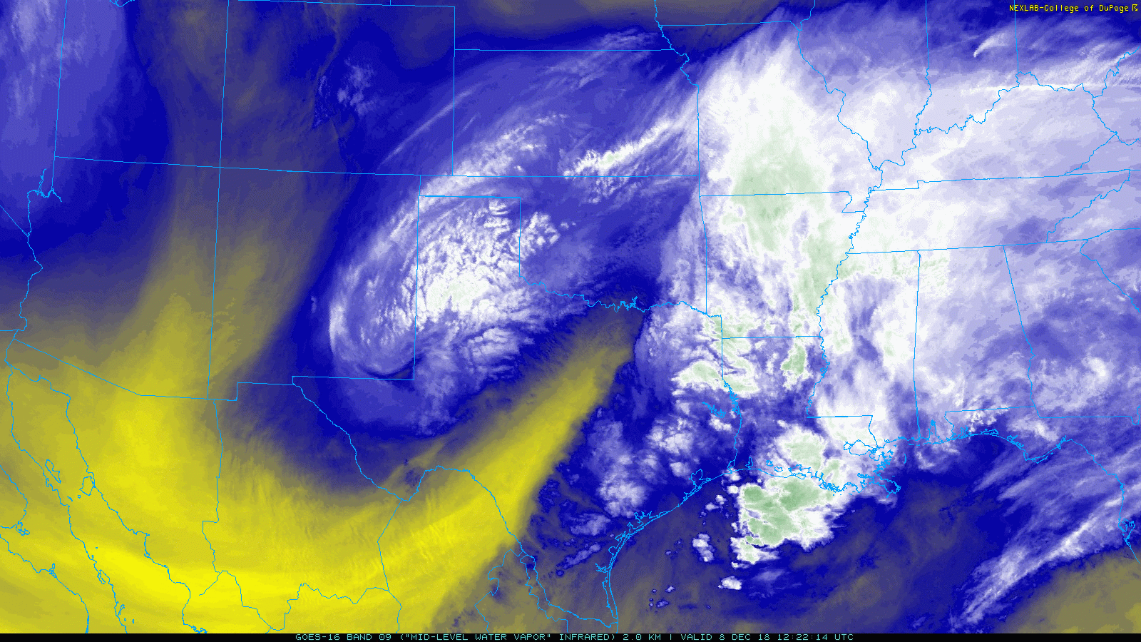
GOES 16 water vapor loop valid from around 6 am to 9 am on 8 December 2018. Note the impressive storm system churning across northwest Texas where it was producing moderate to heavy snow.
Everything changed Friday night as more widespread moderate to heavy precipitation formed and spread into the South Plains in response to the approaching southwestern storm system. Temperatures aloft cooled quickly and this caused the rain to mix with and change to snow Friday evening. Moderate to heavy snow continued overnight into Saturday morning before ending from west to east.
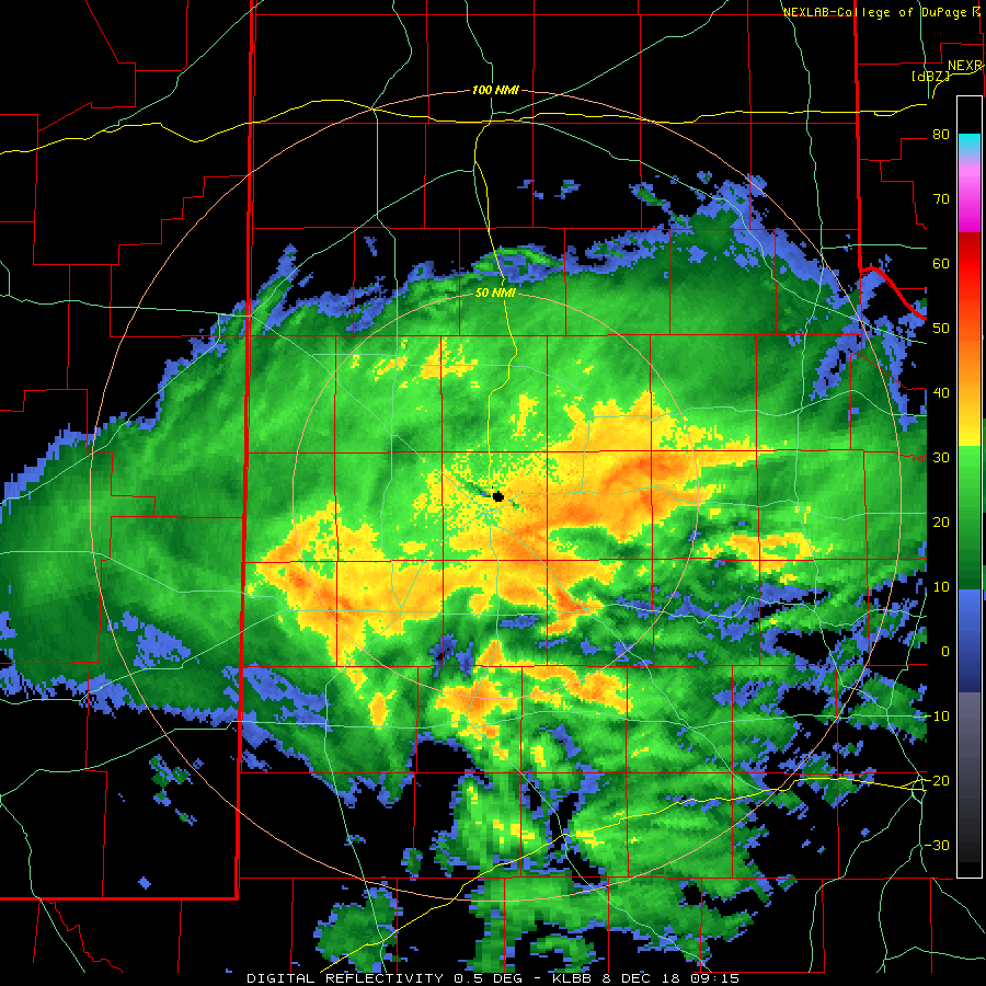
Regional radar animation valid from 8:48 pm to 9:58 pm on 7 December 2018. At this time, most of the precipitation was in liquid form, but it quickly changed over to snow over the next several hours over the South Plains region.
The heavy wet snow quickly piled up through early Saturday morning, with a half a foot or more falling over the central South Plains into the Rolling Plains by daybreak or so.
Snow beginning to accumulate at several different locations around the South Plains at 2 am December 8, 2018.
Lubbock was squarely in the heaviest band of snow, with spots around the city recording from 9 inches to a foot. Snow and ice packed roadways created slick conditions which resulted in numerous accidents. Although dangerous for travel, the snow also created a beautiful scene.
Lubbock radar animation valid from 3:15 am to 8:50 am on 8 December 2018.
As the above radar animation and below snow map show, there was a sharp cutoff between the heavy snow over the central South Plains to very little to no snow north over the Texas Panhandle and south into the Permian Basin.
Snow totals observed around the South Plains region for the 7-8 December 2018 winter storm.
Where the snow band did linger, very heavy snow fell for several hours Saturday morning, with a half a foot to nearly a foot accumulating over much of the central South Plains into the Rolling Plains. Some of the biggest winners were right around Lubbock where many reports of 9 to 11 inches were received.
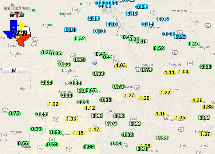
Radar-estimated and bias-corrected liquid water equivalent for the 7-8 December 2018 winter storm. The first shade of green represents 3/4"+, with the second shade of green representing 1"+. A regional view can be VIEWED HERE. The snow that melted in the West Texas Mesonet sites can also be SEEN HERE.
The snow also brought welcome moisture to the region, with liquid water equivalents of a half inch to one inch common where the heaviest band of snow tracked across. Lubbock officially recorded 10 inches of snow and 1.09 inches of liquid from this December winter storm, both setting records for the day.
Visible satellite image captured on 9 December 2018. The white stretching across the South Plains into the Rolling Plains is the broad snow pack left on the ground after the previous day's storm.
The snow lasted for a few days, melting off quickly by late weekend into early the next week as temperatures rose into the 40s and 50s. Before then, the above satellite image shows the impressive swath of snow blanketing the South Plains on Sunday morning.
Additional pictures of snow from around the region. The left picture was taken in Shallowater by Bruce Haynie. The right picture was taken by Marsha Black in west Lubbock.
Above and below are several pictures of the winter wonderland left behind by the winter storm.
More pictures of the winter wonderland around the National Weather Service Office in Lubbock.
A listing of snow reports recorded during this winter storm can be found below.
Public Information Statement
PUBLIC INFORMATION STATEMENT...UPDATED
NATIONAL WEATHER SERVICE LUBBOCK TX
150 PM CST Tue Dec 11 2018

Total snowfall reports for December 7-8 snowstorm.


********************STORM TOTAL SNOWFALL********************

LOCATION          STORM TOTAL     TIME/DATE   COMMENTS
                     SNOWFALL           OF
                     /INCHES/   MEASUREMENT

TEXAS

...Bailey County...
   Muleshoe Wildlife Re   5.0   100 PM 12/08  Storm Total

...Briscoe County...
   Silverton              2.0   930 AM 12/08  Law Enforcement

...Castro County...
   Hart                   3.5   859 AM 12/08  Co-Op Observer

...Childress County...
   Tell                   2.0   843 AM 12/08  Co-Op Observer
   1 W Kirkland           1.5   933 AM 12/08  Co-Op Observer
   7 NW Childress         0.2   855 AM 12/08  Co-Op Observer

...Cochran County...
   Morton                 4.2   906 AM 12/08  Co-Op Observer

...Cottle County...
   10 S Paducah           5.0   200 PM 12/08  Storm Total
   Paducah                3.0   100 PM 12/08  Fire Dept/Rescue

...Crosby County...
   Crosbyton              8.0  1204 PM 12/08  Storm Total
   White River Lake       3.0   300 PM 12/08  Storm Total

...Dickens County...
   Spur                   7.0   200 PM 12/08  Storm Total

...Floyd County...
   9 SE Floydada          9.0  1206 PM 12/08  Storm Total
   Floydada               5.0  1000 AM 12/08  Law Enforcement

...Garza County...
   Lake Alan Henry        2.0   900 AM 12/08  Co-Op Observer

...Hale County...
   Abernathy              7.5   811 AM 12/08  Social Media
   Plainview              4.0  1142 AM 12/08  Law Enforcement

...Hall County...
   Turkey                 3.0   100 PM 12/08  Storm Total

...Hockley County...
   6 NNW Ropesville       8.5   100 PM 12/08  Storm total
   Levelland              6.9   100 PM 12/08  Storm Total

...Kent County...
   Jayton                 5.0   200 PM 12/08  Storm Total

...King County...
   15 S Paducah           8.0   200 PM 12/08  Storm Total
   Dumont                 6.0  1030 AM 12/08  Co-Op Observer
   Guthrie                5.0   200 PM 12/08  Storm Total

...Lamb County...
   Littlefield            9.0  1205 PM 12/08  Social Media
   7 SE Littlefield       6.5   100 PM 12/08  Storm Total
   Olton                  5.0   900 AM 12/08  Co-Op Observer

...Lubbock County...
   4 SW Lubbock          10.5  1130 AM 12/08  34th and Slide
   3 SSW Lubbock         10.5  1116 AM 12/08  Social Media
   5 WSW Lubbock         10.5  1134 AM 12/08  Trained Spotter
   3 ENE Wolfforth       10.0  1007 AM 12/08  NWS Employee
   7 SW Lubbock          10.0   100 PM 12/08  Storm Total
   6 NNE Lubbock         10.0   100 PM 12/08  Lubbock Airport
   Idalou                10.0   209 PM 12/08  Social Media
   4 SSW Lubbock         10.0  1003 AM 12/08  Co-Op Observer
   Shallowater            9.8   200 PM 12/08  Storm Total
   4 WNW Lubbock          9.7  1100 AM 12/08  4th and Slide
   4 E Reese Center       9.3   100 PM 12/08  Storm Total
   1 SW Lubbock           9.0  1130 AM 12/08  NWS Employee
   5 NNW Lubbock          9.0  1220 PM 12/08  North Pointe Area
   4 NW Lubbock           9.0   832 AM 12/08  Broadcast Media
   1 NNE Ransom Canyon    8.8   844 AM 12/08  Public
   5 NW Lubbock           8.0   900 AM 12/08  Social Media
   6 SW Lubbock           8.0   828 AM 12/08  NWS Employee
   5 SW Lubbock           8.0   831 AM 12/08  Trained Spotter
   SSW Lubbock            7.2   812 AM 12/08  78th and Elgin
   3 W Woodrow            7.0   900 AM 12/08  NWS Employee
   7 WSW Lubbock          6.5   905 AM 12/08  NWS Employee
   Slaton                 5.0  1141 AM 12/08  Co-Op Observer
   5 S Wolfforth          4.8   800 AM 12/08  NWS Employee

...Lynn County...
   Tahoka                 5.0   100 PM 12/08  Storm Total

...Motley County...
   Roaring Springs        7.5   200 PM 12/08  Storm Total
   Matador                5.0   830 AM 12/08  Co-Op Observer
   4 NE Flomot            3.5  1206 PM 12/08  Storm Total
   2 E Flomot             3.5  1205 PM 12/08  Storm Total
   Northfield             2.0   200 PM 12/08  Storm Total

...Stonewall County...
   Aspermont              3.5  1202 PM 12/08  Storm Total

...Swisher County...
   Vigo Park              1.5   900 AM 12/08  Co-Op Observer
   Tulia                  1.0   808 AM 12/08  Law Enforcement

...Terry County...
   Brownfield             6.0  1203 PM 12/08  Co-Op Observer

...Yoakum County...
   Plains                 5.0   900 AM 12/08  Law Enforcement
   Denver City            3.0   900 AM 12/08  Co-Op Observer
Local Storm Report
PRELIMINARY LOCAL STORM REPORT...SUMMARY
NATIONAL WEATHER SERVICE LUBBOCK TX
416 PM CST MON DEC 10 2018
..TIME... ...EVENT... ...CITY LOCATION... ...LAT.LON...
..DATE... ....MAG.... ..COUNTY LOCATION..ST.. ...SOURCE....
..REMARKS..
1100 PM SNOW MORTON 33.72N 102.76W
12/07/2018 U0.0 INCH COCHRAN TX LAW ENFORCEMENT
SNOW ACCUMULATION ON ROADS HEADING WEST BETWEEN MORTON
AND WHITEFACE. VISIBILITY DOWN TO 50 YARDS.
1251 AM SNOW 4 E WOLFFORTH 33.51N 101.95W
12/08/2018 M0.7 INCH LUBBOCK TX NWS EMPLOYEE
0145 AM SNOW 3 NW WOODROW 33.48N 101.88W
12/08/2018 M1.0 INCH LUBBOCK TX NWS EMPLOYEE
0202 AM SNOW CROSBYTON 33.64N 101.24W
12/08/2018 E0.5 INCH CROSBY TX LAW ENFORCEMENT
ALL SNOW, COVERING THE GROUND.
0206 AM SNOW DICKENS 33.62N 100.84W
12/08/2018 E0.5 INCH DICKENS TX LAW ENFORCEMENT
SNOW ENOUGH TO COVER THE GROUND, SWITCHED OVER TO ALL
SNOW ABOUT AN HOUR AGO.
0214 AM SNOW 4 SSW LUBBOCK 33.52N 101.90W
12/08/2018 M2.6 INCH LUBBOCK TX CO-OP OBSERVER
MEASRUED AT NWS OFFICE
0215 AM SNOW 3 SSE LUBBOCK SOUTH PLA 33.49N 101.90W
12/08/2018 M1.5 INCH LUBBOCK TX FIRE DEPT/RESCUE
0244 AM SNOW LITTLEFIELD 33.92N 102.33W
12/08/2018 E2.5 INCH LAMB TX LAW ENFORCEMENT
0249 AM SNOW PLAINVIEW 34.19N 101.72W
12/08/2018 M0.1 INCH HALE TX LAW ENFORCEMENT
BARELY ENOUGH TO COVER GROUND BUT RATE IS PICKING UP.
0310 AM SNOW 3 WNW WOODROW 33.46N 101.89W
12/08/2018 M1.5 INCH LUBBOCK TX NWS EMPLOYEE
0330 AM SNOW DICKENS 33.62N 100.84W
12/08/2018 M1.8 INCH DICKENS TX LAW ENFORCEMENT
0411 AM SNOW 2 N DICKENS 33.65N 100.83W
12/08/2018 M2.8 INCH DICKENS TX LAW ENFORCEMENT
0417 AM SNOW LEVELLAND 33.58N 102.36W
12/08/2018 E1.8 INCH HOCKLEY TX LAW ENFORCEMENT
SNOW HEAVIER EAST OF TOWN ALONG HIGHWAY 114
0430 AM SNOW PLAINS 33.19N 102.83W
12/08/2018 E1.0 INCH YOAKUM TX LAW ENFORCEMENT
0514 AM SNOW 6 NNE LUBBOCK 33.67N 101.82W
12/08/2018 M3.0 INCH LUBBOCK TX ASOS
2.5" DEPTH, 3.0" SNOWFALL AS OF 5AM CST
0528 AM SNOW DICKENS 33.62N 100.84W
12/08/2018 M3.8 INCH DICKENS TX LAW ENFORCEMENT
0537 AM SNOW POST 33.19N 101.38W
12/08/2018 E0.2 INCH GARZA TX LAW ENFORCEMENT
ENOUGH TO COVER THE GROUND
0539 AM SNOW 1 SW LUBBOCK 33.57N 101.91W
12/08/2018 E7.0 INCH LUBBOCK TX NWS EMPLOYEE
0552 AM SNOW 3 E LUBBOCK SOUTH PLAI 33.53N 101.88W
12/08/2018 M6.0 INCH LUBBOCK TX CO-OP OBSERVER
MEASURED AT NWS OFFICE
0600 AM SNOW LUBBOCK INT. AIRPORT 33.65N 101.81W
12/08/2018 M6.0 INCH LUBBOCK TX ASOS
0614 AM SNOW PLAINS 33.19N 102.83W
12/08/2018 M1.8 INCH YOAKUM TX LAW ENFORCEMENT
STILL SNOWING
0615 AM SNOW MULESHOE 34.23N 102.73W
12/08/2018 E1.0 INCH BAILEY TX LAW ENFORCEMENT
0617 AM SNOW FARWELL 34.39N 103.04W
12/08/2018 E0.2 INCH PARMER TX LAW ENFORCEMENT
0620 AM SNOW PLAINVIEW 34.19N 101.72W
12/08/2018 E2.0 INCH HALE TX LAW ENFORCEMENT
IN DOWNTOWN PLAINVIEW
0622 AM SNOW TAHOKA 33.16N 101.79W
12/08/2018 M1.5 INCH LYNN TX LAW ENFORCEMENT
STILL SNOWING
0622 AM SNOW LITTLEFIELD 33.92N 102.33W
12/08/2018 E5.0 INCH LAMB TX LAW ENFORCEMENT
0623 AM SNOW MORTON 33.73N 102.76W
12/08/2018 E3.5 INCH COCHRAN TX LAW ENFORCEMENT
0625 AM SNOW 5 S LUBBOCK 33.50N 101.88W
12/08/2018 M4.0 INCH LUBBOCK TX NWS EMPLOYEE
0627 AM SNOW 1 W LEVELLAND 33.58N 102.38W
12/08/2018 E2.0 INCH HOCKLEY TX LAW ENFORCEMENT
0631 AM SNOW 2 SSW LUBBOCK SOUTH PLA 33.50N 101.94W
12/08/2018 M3.8 INCH LUBBOCK TX BROADCAST MEDIA
0632 AM SNOW CAPROCK CANYON ST. 34.45N 101.07W
12/08/2018 E1.0 INCH BRISCOE TX TX PARK SVC
0635 AM SNOW MULESHOE 34.23N 102.73W
12/08/2018 M1.0 INCH BAILEY TX LAW ENFORCEMENT
STILL LIGHTLY SNOWING
0639 AM SNOW MATADOR 34.02N 100.82W
12/08/2018 E1.5 INCH MOTLEY TX LAW ENFORCEMENT
0643 AM SNOW 2 N LITTLEFIELD 33.95N 102.33W
12/08/2018 M6.0 INCH LAMB TX SOCIAL MEDIA
0648 AM SNOW 3 SSE LUBBOCK 33.54N 101.86W
12/08/2018 M5.2 INCH LUBBOCK TX SOCIAL MEDIA
0655 AM SNOW BROWNFIELD 33.18N 102.27W
12/08/2018 M2.5 INCH TERRY TX LAW ENFORCEMENT
STILL SNOWING
0657 AM SNOW TEXAS TECH UNIV. 33.58N 101.86W
12/08/2018 M5.0 INCH LUBBOCK TX LAW ENFORCEMENT
TEXAS TECH POLICE DEPARTMENT
0700 AM SNOW 2 NW PLAINVIEW 34.21N 101.75W
12/08/2018 M3.0 INCH HALE TX CO-OP OBSERVER
PLAINVIEW WATER TREATMENT PLANT
0700 AM SNOW GROW 33.81N 100.30W
12/08/2018 M1.5 INCH KING TX CO-OP OBSERVER
0719 AM SNOW CROSBYTON 33.64N 101.24W
12/08/2018 E4.0 INCH CROSBY TX LAW ENFORCEMENT
STILL SNOWING
0723 AM SNOW 1 NNW WEST END PLACE 33.59N 101.96W
12/08/2018 M6.0 INCH LUBBOCK TX SOCIAL MEDIA
0730 AM SNOW POST 33.19N 101.38W
12/08/2018 M1.2 INCH GARZA TX CO-OP OBSERVER
0731 AM SNOW ASPERMONT 33.14N 100.22W
12/08/2018 E1.2 INCH STONEWALL TX LAW ENFORCEMENT
STILL SNOWING
0739 AM SNOW 3 SSE LUBBOCK SOUTH PLA 33.49N 101.91W
12/08/2018 E7.0 INCH LUBBOCK TX PUBLIC
QUAKER AND 110TH
0739 AM SNOW 1 S WOLFFORTH 33.49N 102.01W
12/08/2018 E5.0 INCH LUBBOCK TX PUBLIC
0756 AM SNOW 5 WSW LUBBOCK 33.55N 101.95W
12/08/2018 M7.0 INCH LUBBOCK TX TRAINED SPOTTER
0800 AM SNOW TAHOKA 33.16N 101.79W
12/08/2018 M4.0 INCH LYNN TX CO-OP OBSERVER
0800 AM SNOW 5 S WOLFFORTH 33.44N 102.01W
12/08/2018 M4.8 INCH LUBBOCK TX NWS EMPLOYEE
0803 AM SNOW JAYTON 33.25N 100.57W
12/08/2018 E1.0 INCH KENT TX LAW ENFORCEMENT
STILL SNOWING
0807 AM SNOW SHALLOWATER 33.69N 101.99W
12/08/2018 M8.2 INCH LUBBOCK TX NWS EMPLOYEE
0808 AM SNOW TULIA 34.54N 101.77W
12/08/2018 M1.0 INCH SWISHER TX LAW ENFORCEMENT
0811 AM SNOW ABERNATHY 33.83N 101.84W
12/08/2018 M7.5 INCH HALE TX SOCIAL MEDIA
0812 AM SNOW SSW LUBBOCK 33.58N 101.88W
12/08/2018 M7.2 INCH LUBBOCK TX SOCIAL MEDIA
78TH AND ELGIN
0816 AM SNOW BROWNFIELD 33.18N 102.27W
12/08/2018 M5.0 INCH TERRY TX CO-OP OBSERVER
0825 AM SNOW 3 ENE WOLFFORTH 33.52N 101.97W
12/08/2018 M7.0 INCH LUBBOCK TX NWS EMPLOYEE
0828 AM SNOW 1 SW LUBBOCK 33.56N 101.88W
12/08/2018 M7.0 INCH LUBBOCK TX NWS EMPLOYEE
0828 AM SNOW 6 SW LUBBOCK 33.51N 101.95W
12/08/2018 M8.0 INCH LUBBOCK TX NWS EMPLOYEE
0830 AM SNOW MATADOR 34.02N 100.82W
12/08/2018 M5.0 INCH MOTLEY TX CO-OP OBSERVER
0831 AM SNOW 5 SW LUBBOCK 33.53N 101.93W
12/08/2018 M8.0 INCH LUBBOCK TX TRAINED SPOTTER
0832 AM SNOW 4 NW LUBBOCK 33.61N 101.92W
12/08/2018 M9.0 INCH LUBBOCK TX BROADCAST MEDIA
0833 AM SNOW NORTHFIELD 34.29N 100.60W
12/08/2018 M1.5 INCH MOTLEY TX CO-OP OBSERVER
0840 AM SNOW IDALOU 33.66N 101.68W
12/08/2018 M8.0 INCH LUBBOCK TX FIRE DEPT/RESCUE
0843 AM SNOW TELL 34.38N 100.39W
12/08/2018 M2.0 INCH CHILDRESS TX CO-OP OBSERVER
0844 AM SNOW 1 NNE RANSOM CANYON 33.55N 101.68W
12/08/2018 M8.8 INCH LUBBOCK TX PUBLIC
0855 AM SNOW 7 NW CHILDRESS 34.50N 100.34W
12/08/2018 M0.2 INCH CHILDRESS TX CO-OP OBSERVER
0856 AM SNOW CROSBYTON 33.64N 101.24W
12/08/2018 M6.0 INCH CROSBY TX CO-OP OBSERVER
0857 AM SNOW 2 E FLOMOT 34.23N 100.95W
12/08/2018 M3.0 INCH MOTLEY TX CO-OP OBSERVER
0858 AM SNOW 9 SE FLOYDADA 33.89N 101.23W
12/08/2018 M8.0 INCH FLOYD TX CO-OP OBSERVER
0859 AM SNOW HART 34.39N 102.11W
12/08/2018 M3.5 INCH CASTRO TX CO-OP OBSERVER
0900 AM SNOW LEVELLAND 33.58N 102.36W
12/08/2018 M5.6 INCH HOCKLEY TX CO-OP OBSERVER
0900 AM SNOW 5 NW LUBBOCK 33.63N 101.94W
12/08/2018 M8.0 INCH LUBBOCK TX SOCIAL MEDIA
0900 AM SNOW OLTON 34.18N 102.14W
12/08/2018 M5.0 INCH LAMB TX CO-OP OBSERVER
0900 AM SNOW 6 NNW ROPESVILLE 33.49N 102.19W
12/08/2018 M7.5 INCH HOCKLEY TX CO-OP OBSERVER
LIGHT GLAZE REPORTED UNDER THE SNOW AS WELL
0900 AM SNOW WHITE RIVER LAKE 33.48N 101.10W
12/08/2018 M3.0 INCH CROSBY TX CO-OP OBSERVER
0900 AM SNOW 3 W WOODROW 33.45N 101.90W
12/08/2018 M7.0 INCH LUBBOCK TX NWS EMPLOYEE
0900 AM SNOW ASPERMONT 33.14N 100.22W
12/08/2018 M0.5 INCH STONEWALL TX CO-OP OBSERVER
0900 AM SNOW 14 NNW CHILDRESS 34.61N 100.34W
12/08/2018 M0.0 INCH CHILDRESS TX CO-OP OBSERVER
ONLY A TRACE OF SNOWFALL FELL
0900 AM SNOW DENVER CITY 32.97N 102.83W
12/08/2018 M3.0 INCH YOAKUM TX CO-OP OBSERVER
0900 AM SNOW LAKE ALAN HENRY 33.06N 101.05W
12/08/2018 M2.0 INCH GARZA TX CO-OP OBSERVER
0900 AM SNOW PLAINS 33.19N 102.83W
12/08/2018 E5.0 INCH YOAKUM TX LAW ENFORCEMENT
0900 AM SNOW VIGO PARK 34.65N 101.50W
12/08/2018 E1.5 INCH SWISHER TX CO-OP OBSERVER
0901 AM SNOW 4 SSW LUBBOCK 33.52N 101.90W
12/08/2018 M9.5 INCH LUBBOCK TX CO-OP OBSERVER
MEASURED AT NWS OFFICE LUBBOCK
0903 AM SNOW 7 SE LITTLEFIELD 33.85N 102.25W
12/08/2018 M3.5 INCH LAMB TX CO-OP OBSERVER
0905 AM SNOW 7 WSW LUBBOCK 33.54N 101.99W
12/08/2018 M6.5 INCH LUBBOCK TX NWS EMPLOYEE
0906 AM SNOW MORTON 33.72N 102.76W
12/08/2018 M4.2 INCH COCHRAN TX CO-OP OBSERVER
0908 AM SNOW IDALOU 33.66N 101.68W
12/08/2018 M8.0 INCH LUBBOCK TX PUBLIC
0910 AM SNOW 4 E REESE CENTER 33.59N 101.96W
12/08/2018 M8.4 INCH LUBBOCK TX CO-OP OBSERVER
0913 AM SNOW 7 SW LUBBOCK 33.50N 101.96W
12/08/2018 M9.0 INCH LUBBOCK TX NWS EMPLOYEE
0930 AM SNOW SILVERTON 34.47N 101.30W
12/08/2018 M2.0 INCH BRISCOE TX LAW ENFORCEMENT
0933 AM SNOW 1 W KIRKLAND 34.39N 100.09W
12/08/2018 M1.5 INCH CHILDRESS TX CO-OP OBSERVER
1000 AM SNOW FLOYDADA 33.98N 101.34W
12/08/2018 E5.0 INCH FLOYD TX LAW ENFORCEMENT
1003 AM SNOW 4 SSW LUBBOCK 33.52N 101.90W
12/08/2018 M10.0 INCH LUBBOCK TX CO-OP OBSERVER
MEASURED AT NWS OFFICE LUBBOCK
1007 AM SNOW 3 ENE WOLFFORTH 33.52N 101.97W
12/08/2018 M10.0 INCH LUBBOCK TX NWS EMPLOYEE
1030 AM SNOW DUMONT 33.80N 100.52W
12/08/2018 M6.0 INCH KING TX CO-OP OBSERVER
1100 AM SNOW 4 WNW LUBBOCK 33.60N 101.94W
12/08/2018 M9.7 INCH LUBBOCK TX TRAINED SPOTTER
4TH AND SLIDE
1116 AM SNOW 3 SSW LUBBOCK 33.54N 101.89W
12/08/2018 M10.5 INCH LUBBOCK TX SOCIAL MEDIA
1127 AM SNOW ASPERMONT 33.14N 100.22W
12/08/2018 E2.0 INCH STONEWALL TX LAW ENFORCEMENT
1130 AM SNOW 1 SW LUBBOCK 33.56N 101.88W
12/08/2018 M9.0 INCH LUBBOCK TX NWS EMPLOYEE
1130 AM SNOW 4 SW LUBBOCK 33.53N 101.92W
12/08/2018 M10.5 INCH LUBBOCK TX SOCIAL MEDIA
34TH AND SLIDE
1131 AM SNOW JAYTON 33.25N 100.57W
12/08/2018 E3.0 INCH KENT TX LAW ENFORCEMENT
1134 AM SNOW 5 WSW LUBBOCK 33.55N 101.96W
12/08/2018 M10.5 INCH LUBBOCK TX TRAINED SPOTTER
1141 AM SNOW SLATON 33.44N 101.64W
12/08/2018 M5.0 INCH LUBBOCK TX CO-OP OBSERVER
1142 AM SNOW PLAINVIEW 34.19N 101.72W
12/08/2018 E4.0 INCH HALE TX LAW ENFORCEMENT
1202 PM SNOW ASPERMONT 33.14N 100.22W
12/08/2018 M3.5 INCH STONEWALL TX CO-OP OBSERVER
STORM TOTAL
1203 PM SNOW BROWNFIELD 33.18N 102.27W
12/08/2018 M6.0 INCH TERRY TX CO-OP OBSERVER
1204 PM SNOW CROSBYTON 33.64N 101.24W
12/08/2018 M8.0 INCH CROSBY TX CO-OP OBSERVER
STORM TOTAL
1205 PM SNOW LITTLEFIELD 33.92N 102.33W
12/08/2018 M9.0 INCH LAMB TX SOCIAL MEDIA
1205 PM SNOW 2 E FLOMOT 34.23N 100.95W
12/08/2018 M3.5 INCH MOTLEY TX CO-OP OBSERVER
STORM TOTAL
1206 PM SNOW 4 NE FLOMOT 34.27N 100.94W
12/08/2018 M3.5 INCH MOTLEY TX CO-OP OBSERVER
STORM TOTAL
1206 PM SNOW 9 SE FLOYDADA 33.89N 101.23W
12/08/2018 M9.0 INCH FLOYD TX CO-OP OBSERVER
STORM TOTAL
1220 PM SNOW 5 NNW LUBBOCK 33.64N 101.91W
12/08/2018 M9.0 INCH LUBBOCK TX SOCIAL MEDIA
NORTH POINTE AREA
0100 PM SNOW PADUCAH 34.01N 100.30W
12/08/2018 E3.0 INCH COTTLE TX FIRE DEPT/RESCUE
0100 PM SNOW LEVELLAND 33.58N 102.36W
12/08/2018 M6.9 INCH HOCKLEY TX CO-OP OBSERVER
STORM TOTAL
0100 PM SNOW 7 SE LITTLEFIELD 33.85N 102.25W
12/08/2018 M6.5 INCH LAMB TX CO-OP OBSERVER
STORM TOTAL
0100 PM SNOW 7 SW LUBBOCK 33.50N 101.96W
12/08/2018 M10.0 INCH LUBBOCK TX CO-OP OBSERVER
STORM TOTAL
0100 PM SNOW 6 NNE LUBBOCK 33.67N 101.82W
12/08/2018 M10.0 INCH LUBBOCK TX WX OBSERVER FAA
LUBBOCK AIRPORT
0100 PM SNOW MULESHOE WILDLIFE REFUG 33.95N 102.75W
12/08/2018 M5.0 INCH BAILEY TX CO-OP OBSERVER
STORM TOTAL
0100 PM SNOW 4 E REESE CENTER 33.59N 101.96W
12/08/2018 M9.3 INCH LUBBOCK TX CO-OP OBSERVER
STORM TOTAL
0100 PM SNOW 6 NNW ROPESVILLE 33.49N 102.19W
12/08/2018 M8.5 INCH HOCKLEY TX CO-OP OBSERVER
STORM TOTAL
0100 PM SNOW TAHOKA 33.16N 101.79W
12/08/2018 M5.0 INCH LYNN TX CO-OP OBSERVER
STORM TOTAL
0100 PM SNOW TURKEY 34.39N 100.90W
12/08/2018 M3.0 INCH HALL TX CO-OP OBSERVER
STORM TOTAL
0200 PM SNOW GUTHRIE 33.63N 100.32W
12/08/2018 M5.0 INCH KING TX CO-OP OBSERVER
STORM TOTAL
0200 PM SNOW JAYTON 33.25N 100.57W
12/08/2018 M5.0 INCH KENT TX CO-OP OBSERVER
STORM TOTAL
0200 PM SNOW NORTHFIELD 34.29N 100.60W
12/08/2018 M2.0 INCH MOTLEY TX CO-OP OBSERVER
STORM TOTAL
0200 PM SNOW 10 S PADUCAH 33.87N 100.30W
12/08/2018 M5.0 INCH COTTLE TX CO-OP OBSERVER
STORM TOTAL
0200 PM SNOW 15 S PADUCAH 33.80N 100.30W
12/08/2018 M8.0 INCH KING TX CO-OP OBSERVER
STORM TOTAL
0200 PM SNOW ROARING SPRINGS 33.90N 100.86W
12/08/2018 M7.5 INCH MOTLEY TX CO-OP OBSERVER
STORM TOTAL
0200 PM SNOW SHALLOWATER 33.69N 101.99W
12/08/2018 M9.8 INCH LUBBOCK TX CO-OP OBSERVER
STORM TOTAL
0200 PM SNOW SPUR 33.48N 100.85W
12/08/2018 M7.0 INCH DICKENS TX CO-OP OBSERVER
STORM TOTAL
0209 PM SNOW IDALOU 33.66N 101.68W
12/08/2018 E10.0 INCH LUBBOCK TX SOCIAL MEDIA
0300 PM SNOW WHITE RIVER LAKE 33.48N 101.10W
12/08/2018 M3.0 INCH CROSBY TX CO-OP OBSERVER
STORM TOTAL


