| First Winter Storm of the Season 11-12 November 2018 |
 |
| Sleet and snow falling in Silverton late Sunday evening (11 November 2018). |
| The first winter storm of the season affected West Texas late Sunday into Monday (11-12 November 2018). A cold front moved through the South Plains region on Sunday, with the coldest air of the fall season pouring in Sunday night into Monday. At the same time, an upper level storm system approached via the Four Corners late Sunday. Lift from the approaching storm system caused precipitation to increase in coverage and intensity Sunday evening. There was even enough elevated instability that scattered thunderstorms accompanied the strongest activity Sunday evening. |
 |
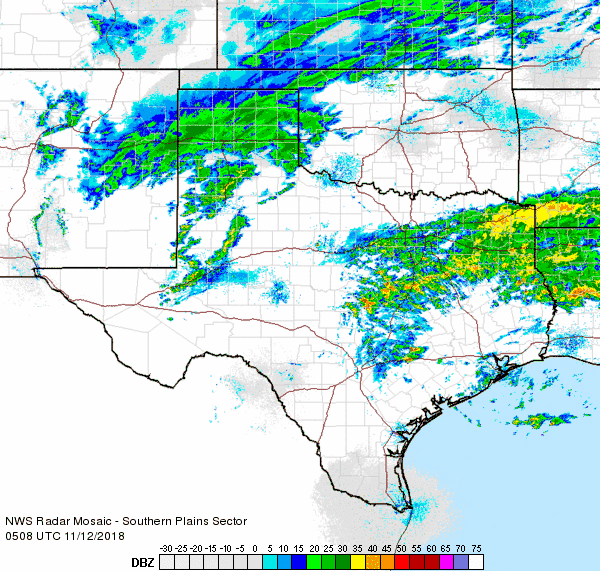
| Regional radar animation valid from 6:48 pm to 7:58 pm on Sunday, 11 November 2018. Additional radar animations can be found at: 9:38 pm to 10:48 pm on Sunday and 11:08 pm to 12:18 am late Sunday into early Monday |
| Where temperatures were cold enough, moderate to heavy snow blossomed in a band from east-central New Mexico into the central Texas Panhandle. This is where the heaviest snow of the event fell, from 6 to 8 inches in a swath from north of Vega through Dumas to south of Spearman. Further south, it was initially "warm" enough that the precipitation fell in the form of sleet and/or a cold rain. As the cold air deepened, the wintry mix changed to snow through early Monday morning. |
 |
| Sleet and snow falling in Friona late Sunday evening (11 November 2018). The image is courtesy of Michael Villa. |
| Locations from Friona to Hart, Tulia and Silverton saw periods of sleet and snow Sunday evening, expanding to include a good portion of the South Plains and northern Rolling Plains by Monday morning. In Lubbock, a couple of rounds of rain and sleet raced by before switching to light snow and flurries early Monday morning. Where the heavier sleet and snow fell it did create travel difficulties. |
 |
| Regional radar animation valid from 4:38 am to 5:48 am on Monday, 12 November 2018. |
| The heaviest snowfall in NWS Lubbock's area of responsibility, 1 to 4 inches, fell across the northern South Plains into the southern Texas Panhandle, with even higher totals, in excess of a half foot, noted over the central Texas Panhandle. Much of the remainder of the South Plains and Rolling Plains saw lighter totals, mostly a trace to a light dusting. |
 |
| Snow and sleet observed across the South Plains during the 11-12 November winter weather event. Higher snow totals were found further north across the central Texas Panhandle. A graphic showing observed snowfall further north, produced by NWS Amarillo, can be VIEWED HERE. |
| Most of the region experienced at least light precipitation (see the below graphic), with the heaviest swaths of moisture falling in the heavy snow from east-central New Mexico into the Texas Panhandle as well over the eastern part of Texas. Lubbock officially record 0.06 inches of liquid equivalent and a trace of snow. Several tenths of an inch of moisture or more were recorded across parts of the Rolling Plains into much of the Texas Panhandle. |
 |
| 24-hour radar-estimated and bias-corrected liquid equivalent precipitation ending at 1 pm on 12 November 2018. A close up of the South Plains region can be ACCESSED HERE. The measured (melted) rain/sleet/snow from the West Texas Mesonet can be FOUND HERE. |
| In addition to the wintry precipitation, gusty northerly winds continued to blow through the day Monday when temperatures flat-lined in the 20s and lower 30s. The combination of the cold temperatures and wind made it feel like the single digits and teens on Monday. |
 |
| Observed low temperatures the morning of Tuesday, 13 November 2018. The data are courtesy of the West Texas Mesonet. |
| Skies eventually cleared and winds diminished enough to allow temperatures to bottom out in the teens and lower 20s Tuesday morning. A few locations across the southwest Texas Panhandle even dipped into the single digits. |

