| Severe Thunderstorms Drop Giant Hail and Heavy Rain 19 May 2018 |
|
 |
|
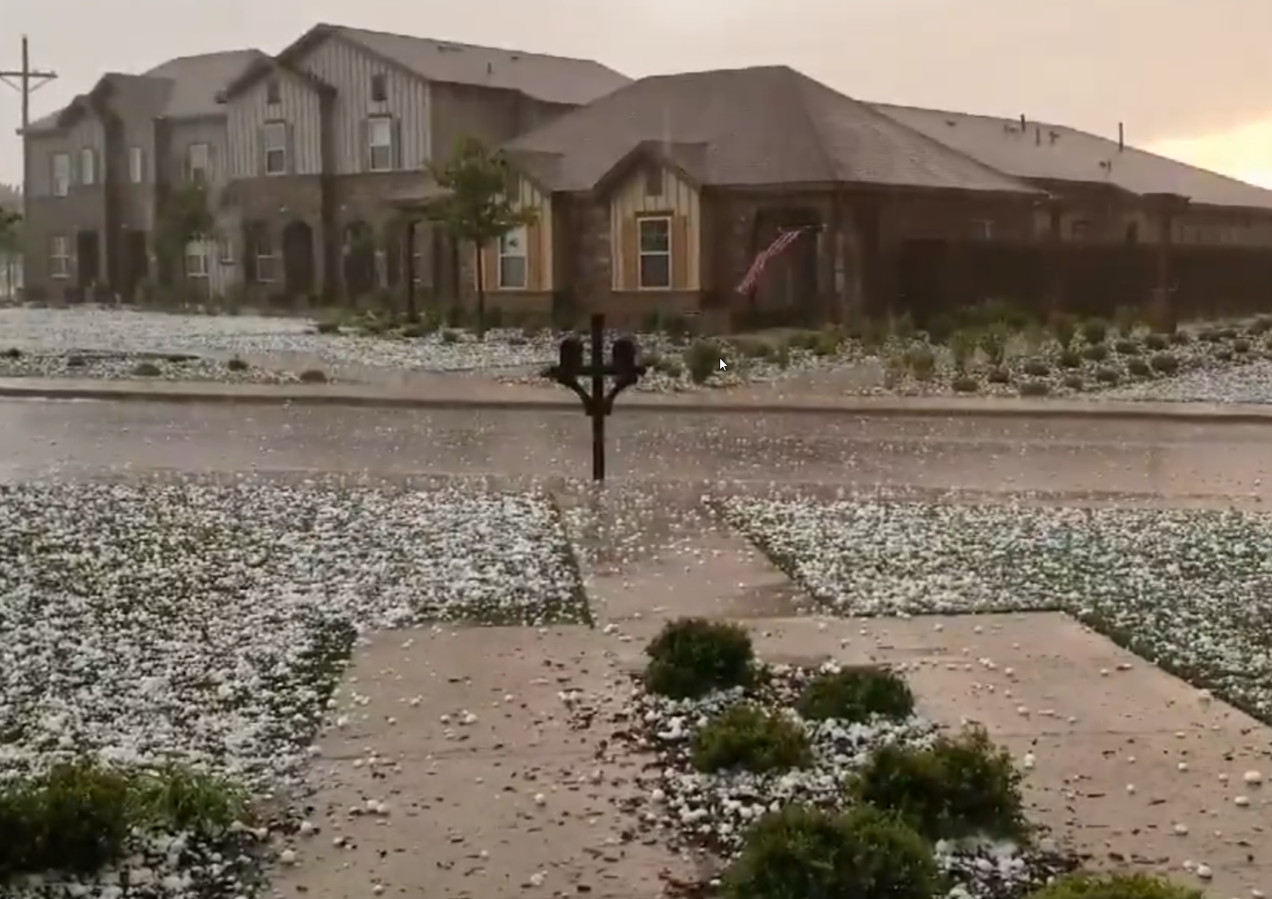
| Large hail that fell in southwest Lubbock Saturday evening (19 May 2018). The picture is courtesy of Robert Barritt. | |
| A nearly stationary boundary joined forces with a passing upper level disturbance, approaching cold front, and returning Gulf moisture to spark widespread strong and severe thunderstorms over the South Plains region Saturday evening and overnight (19 May 2018). The most intense storms generated giant hail and very heavy rainfall. | |
 |
|
| Regional radar animation valid from 7:18 pm to 8:28 pm on 19 May 2018. Additional animations can be found at: 4:28 pm to 5:38 pm on 19 May 2018; and 9:18 pm to 10:28 pm on 19 May 2018. | |
| Initially, widely scattered thunderstorms developed along the nearly stationary boundary from the east-central South Plains into the northern Rolling Plains during the afternoon. A couple of these storms became marginally severe in the Rolling Plains, dropping quarter sized hail in Paducah, before moving eastward into southwest Oklahoma and western North Texas. | |
 |
|
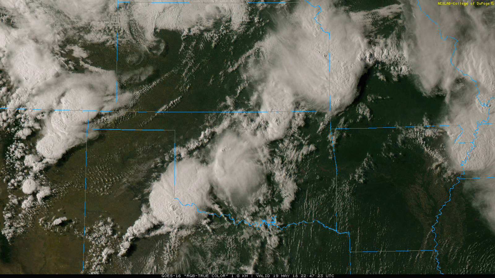
| GOES 16 RGB - True Color imagery captured at 5:47 pm on 19 May 2018. This image shows the early development of showers and thunderstorms along a nearly stationary surface boundary. | |
| Thunderstorms then quickly expanded in coverage and intensity over this same axis as moisture and instability accelerated into the area from the southeast. Several rotating supercell thunderstorms formed over the central South Plains and then generally moved slowly eastward, spewing very large hail and torrential rainfall in spots. | |
 |
|
| Looking east from Lubbock at a developing severe thunderstorm at 6:02 pm on 19 May 2018. | |
| One of these intense rotating storms lingered near Slaton while another moved over southwest Lubbock. Both locations recorded golf ball to baseball size hail, with a few observations of hail to 3 inches in diameter. This giant hail did cause a lot of damage to vehicles, windows and buildings. | |
 |
|
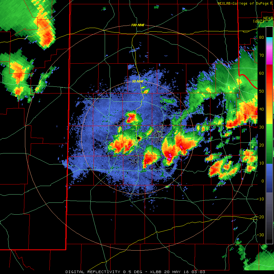
| Lubbock WSR-88D base reflectivity animation valid from 8:23 pm to 9:04 pm on 19 May 2018. An additional animation valid from 10:03 pm to 10:50 pm can be FOUND HERE. | |
| In addition to spilling large hail, the slow-moving supercells also released torrential rainfall rates, with many locations receiving 1 to 2+ inches of rainfall in under an hour. The very intense rainfall rates and sizable rain totals also lead to areas of flooding. | |
 |
|
| GOES-16 dirty infrared imagery (Band 15) captured at 11:02 pm on 19 May 2018. This picture shows the expansive cold cloud tops associated with the large complex of strong and severe thunderstorms. | |
| The thunderstorms gradually weakened in intensity through the late evening and overnight hours as they sagged southeastward. However, they formed into a large complex that brought widespread heavy rain to the southeastern South Plains and much of the Rolling Plains before moving on early Sunday morning (20 May). | |
 |
|
| Regional radar animation valid from 10:48 pm to 11:58 pm on 19 May 2018. An additional animation can be found at: 1:08 am to 2:28 am on 20 May 2018. | |
| A strong cold front then moved in from the north during the late evening and overnight hours. In addition to carrying in much cooler air, the front also helped generate additional strong thunderstorms over the Texas Panhandle and northeast New Mexico. This activity moved more quickly southeastward, bringing brief downpours and wind gusts to 40 to 50+ mph. The Amherst West Texas Mesonet station recorded a peak gust of 59 mph at 1:55 am with these thunderstorms, though most other locations saw sub-severe gusts. | |
 |
|
| 24 hours MESH (Maximum Estimated Size of Hail) calculated by MRMS (Multi-Radar/Multi-Sensor), ending at 3 pm on 20 May 2018. The green represents expected hail size of 1" diameter, while yellow to red represents expected hail sizes of 2" to 3" diameter. | |
| The above image shows where the largest hail fell during the evening and overnight from the 19th into early on the 20th from the the MRMS radar product. The expansive coverage of the blue suggests that many locations likely saw at least small hail, with numerous pockets of larger hail from southern Lubbock and central and northern Lynn Counties eastward to near White River Lake and Kalgary. It is interesting that the hail size over southwest Lubbock was "only" estimated to be around golf ball size when baseball size or larger fell in a narrow swath. This discrepancy may be partially attributed to its close proximity to the Lubbock radar (not sampling the upper levels of the storm as well as a little further from the radar), and the fact that supercells with giant Bounded Weak Echo Regions (BWERs), which these storms had, often cause the algorithm to underestimate the hail size. | |
 |
|
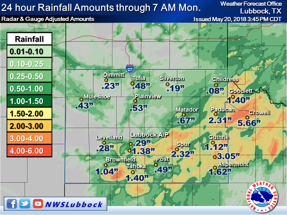
| 24 hours rainfall totals ending at 7 am on 20 May 2018. Additional radar-estimated and bias-corrected 24 hour rain totals ending at 7 am on 20 May 2018 can be found at: REGIONAL VIEW and SOUTH PLAINS VIEW. A plot of the 24 hour rain totals for the West Texas Mesonet can also be ACCESSED HERE. | |
| The positive side of all of the severe weather is that the thunderstorms did drop beneficial rainfall over a good chunk of the region in the midst of a flexing drought. Many locations from the southeast South Plains into the Rolling Plains recorded 1 to 2+ inches of rainfall. Localized flooding did occur due to the very intense rates in spots, but overall the rainfall was welcome. Unfortunately, the western South Plains largely missed out on the rain. | |
| The preliminary storm report for the event can be FOUND HERE. | |
 |
 |
| Images of hail in southwest Lubbock captured on 19 May 2018. The left picture is courtesy of John Holsenbeck and the right is from Emma Weston. | |
| Above and below are additional pictures taken from in and around the Lubbock area on the evening of the 19th. | |
 |
 |
| (Left) Severe warned storm just east of Lubbock on the 19th, courtesy of Timothy Sliwinski. (right) Large hail that fell near 114th and Chicago in southwest Lubbock. Picture is courtesy of Jacoby Madewell. | |

