| Rounds of Severe Thunderstorms hit parts of West Texas 13-17 May 2018 |
|
 |
|
| Supercell thunderstorm west of Childress on the evening of Sunday, 13 May 2018. The picture is courtesy of Bruce Haynie. | |
| The weather in the middle of May turned active, as it is prone to do over West Texas in spring. An increase in moisture and instability combined with a wandering dryline and occasionally perturbed southwest flow aloft to trigger several rounds of severe thunderstorms in the region between Sunday, May 13th and Thursday, May 17th. | |
 |
|
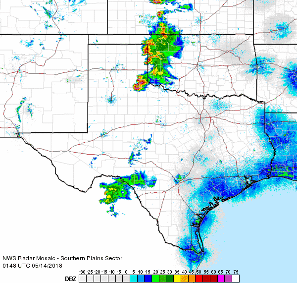
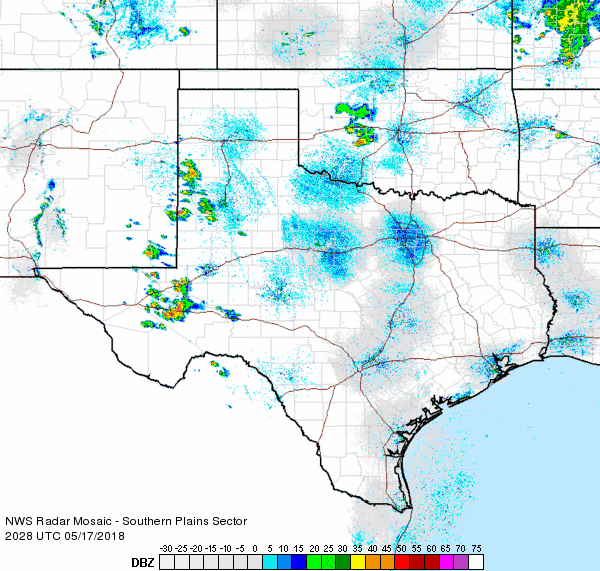
| Regional radar animation valid from 6:48 pm to 7:58 pm on 13 May 2018. Additional animations can be found at: 4:18 pm to 5:28 pm on 13 May 2018; and 8:48 pm to 9:58 pm on 13 May 2018. | |
| The first round of severe thunderstorms developed Sunday evening (13 May) across the eastern Texas Panhandle and far northern Rolling Plains. Parts of Hall and Childress Counties were most favored, as thunderstorms continued to redevelop and track over this same region much of the evening. In addition to dumping torrential rainfall the most intense storms produced giant hail and damaging wind gusts. | |
 |
|
| Large hail that fell near Estelline on the evening of 13 May 2018. The picture is courtesy of Farrah Holcomb. | |
| Locations in and around Estelline were particularly hard hit, receiving several rounds of severe hail. The largest hail reported just south of town was the size and shape of lemons (above). Unfortunately this hail was also driven by winds measured as high as 68 mph at the nearby West Texas Mesonet site. | |
 |
 |
| Damage sustained from large hail and strong winds in and near Estelline on 13 May 2018. The pictures are courtesy of Jose Duran and Farrah Holcomb. | |
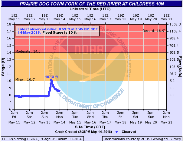
| The combination of the wind and hail caused considerable damage to vehicles and buildings in and around the Estelline area Sunday evening. Additionally, torrential rainfall flooded some roadways and briefly pushed the Prairie Dog Town Fork of the Red River at Childress 10N above minor flood stage. | |
 |
|
| Regional radar animation valid from 5:38 pm to 6:48 pm on 14 May 2018. An additional radar animation from the Lubbock radar can be found at: 2:54 pm to 4:27 pm on 14 May 2018. | |
| The next day (Monday, 14 May) brought another round of severe weather during the afternoon and evening hours. As opposed to the previous day, the showers and thunderstorms developed much further west, starting up on the Caprock, before growing upscale into a complex as they moved into the Rolling Plains and southeast Texas Panhandle. The most intense storms generated wind gusts as high as 77 mph near Northfield and 75 mph in Childress. The intense winds downed a power pole north of Tell, damaged many trees near Estelline and blew over a tractor trailer on US-287 southeast of Estelline. | |
 |
|
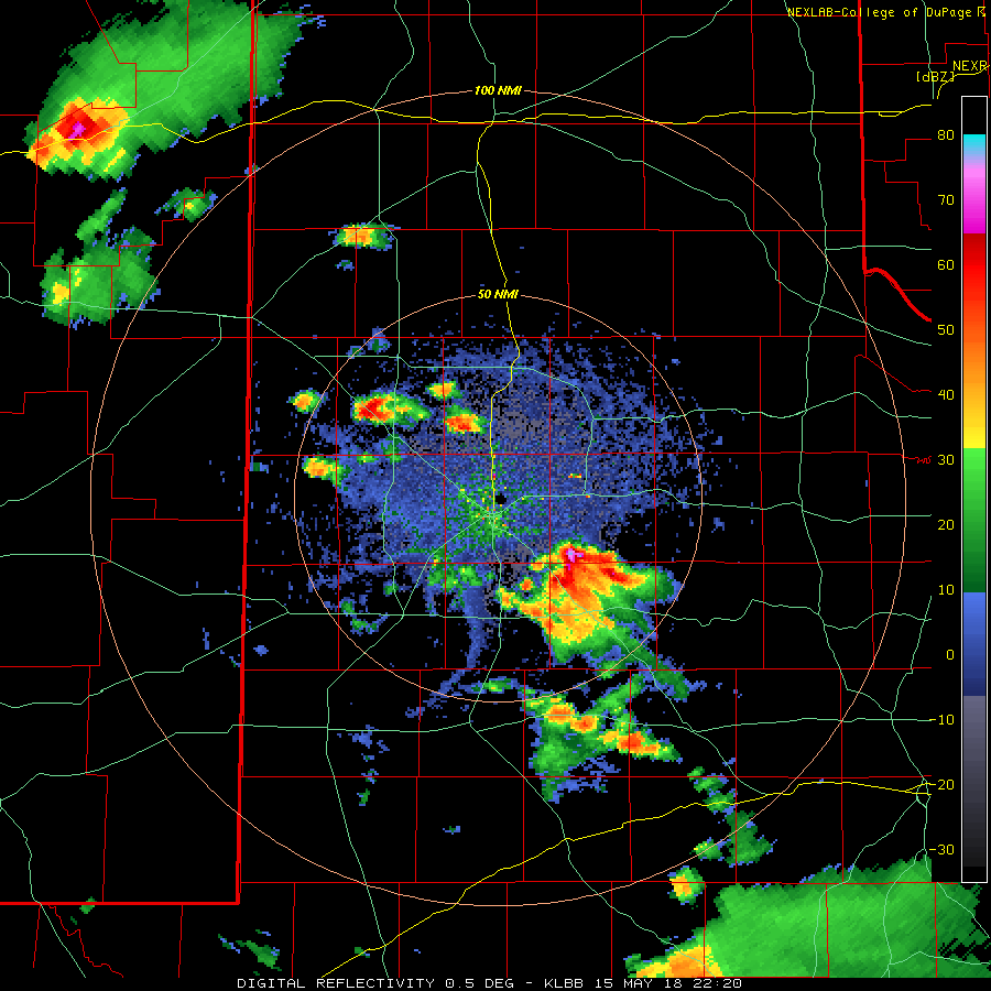
| Regional radar animation valid from 7:48 pm to 8:58 pm on 15 May 2018. Additional animations can be found at: 5:38 pm to 6:48 pm on 15 May 2018; and 9:08 pm to 10:18 pm on 15 May 2018. | |
| Tuesday (15 May) brought another round of severe thunderstorms to the region. This activity initially developed from northeast New Mexico southeastward through the central South Plains during the afternoon before propagating eastward. Quarter to golf ball size hail was common with many of the storms, including over the northwest side of Lubbock. | |
 |
|
| Radar animation from the Lubbock WSR-88D valid from 5:20 pm to 6:29 pm on 15 May 2018. | |
| Crosbyton was particularly hard hit, as a left-moving storm (seen in the above radar animation) produced wind-driven baseball sized hail. The giant hail defoliated trees, caused significant damage to vehicles, roofs and siding, and shattered many south facing windows. After this storm weakened, a larger long-lived severe thunderstorm tracked from the southwest Texas Panhandle through the northeast South Plains and northern Rolling Plains. Numerous reports of severe wind gusts of 60 to 70 mph accompanied this storm along with a few reports of hail. The intense winds caused roof damage to a warehouse in Hart and flipped a semi on I-27 near Plainview. | |
 |
|
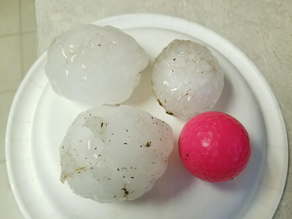
| Large hail that fell in Crosbyton the evening of 15 May 2018. The image is courtesy of Billy Tidwell. | |
| Above is a picture of the large hail that fell in the Crosbyton area on the evening of the 15th. | |
 |
|
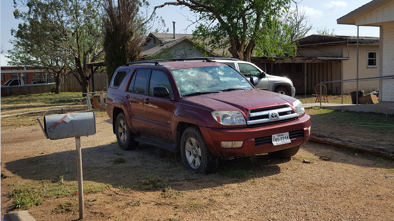
| Wind driven hail did extensive damage to vehicles, trees and buildings in Crosbyton on 15 May 2018. This picture was taken by Justin Weaver the following day. | |
| Above and below are a couple of pictures of damage that the hail and wind inflicted in Crosbyton on the 15th. | |
 |
|
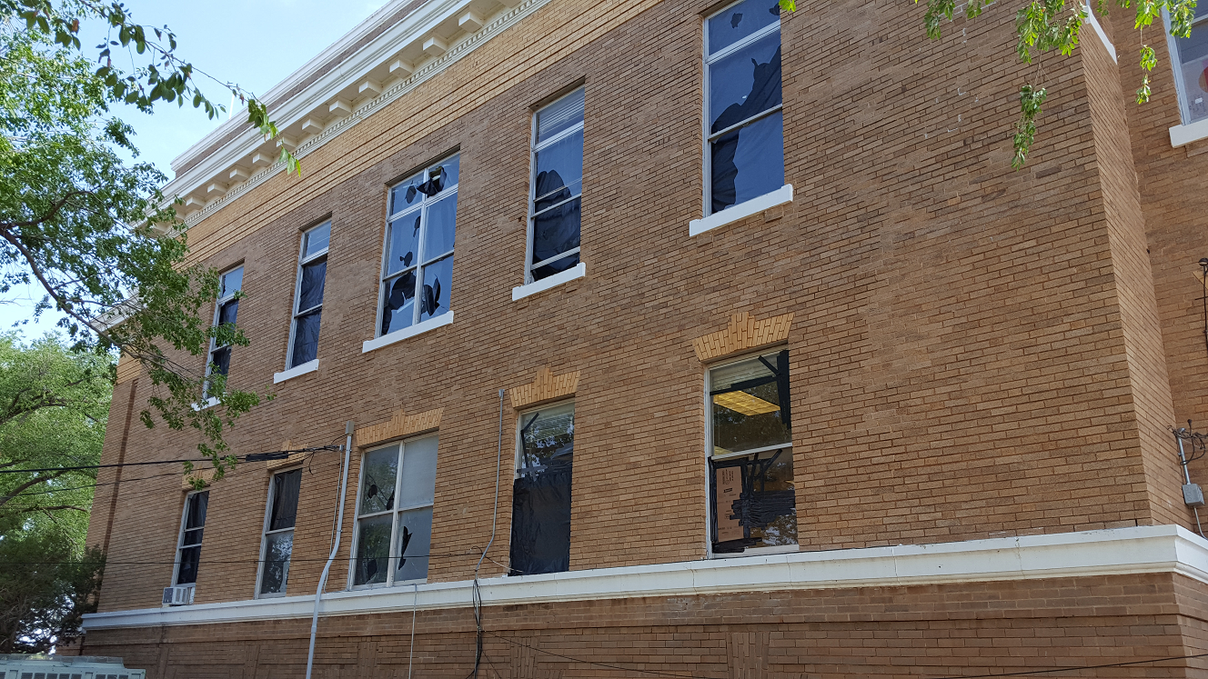
| Wind driven hail did extensive damage to vehicles, trees and buildings in Crosbyton on 15 May 2018. This picture of the southwest facing side of the County Courthouse was taken by Justin Weaver the following day. | |
| Below are a couple of pictures captured from around Lubbock on May 15th. | |
 |
 |
| Storms that affected Lubbock on the evening of 15 May 2018 did drop hail in spots, but also made for a beautiful sky. The left image was taken near 4th and Milwaukee (courtesy of KCBD), while the right image was snapped from south Lubbock (courtesy of Erin Shaw). | |
| The next day, Wednesday (16 May), brought a brief reprieve with only scattered sub-severe thunderstorms off the Caprock during the morning. However, the following day brought a return of severe weather to the South Plains region. High-based storms initially fired across the western South Plains and southwest Texas Panhandle in relatively dry air. | |
 |
|
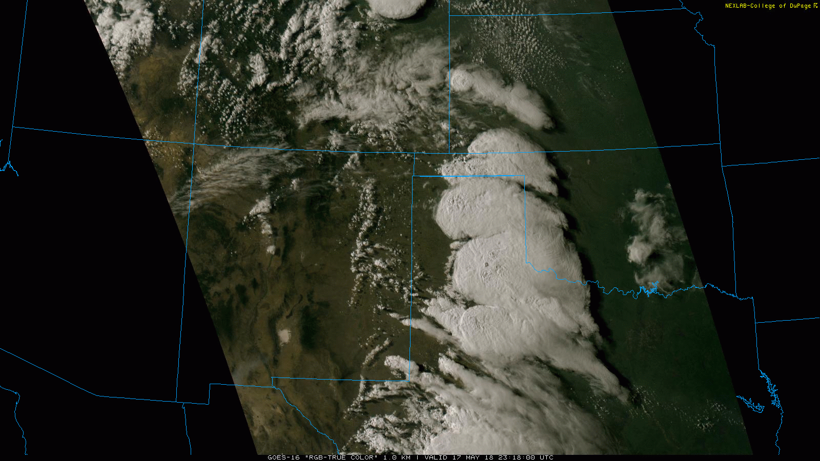
| "True Color" satellite image taken at 6:18 pm on 17 May 2018. | |
| As the thunderstorms moved eastward into better moisture they grew in coverage and intensity. A number of storms produced quarter size hail, including in Wolfforth, southwest Lubbock, near Tokio, Hart and Cedar Hill. | |
 |
 |
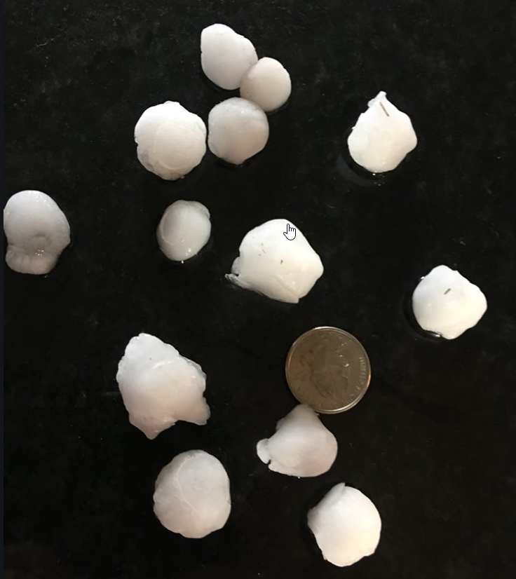
| Hail that fell in Wolfforth (left) and Floydada (right) on the evening of 17 May. The left picture is courtesy of Weather Bar and right is from KCBD. | |
| The most intense storms also began generating severe wind gusts. The West Texas Mesonet sites near Vigo Park and Aiken both measured wind gusts to 66 mph associated with a large cluster of storms. These storms also produced a wind gust to 74 mph near Northfield. | |
 |
|
| Regional radar animation valid from 5:48 pm to 6:58 pm on 17 May 2018. An additional animation can be found at: 3:28 pm to 4:38 pm on 17 May 2018. | |
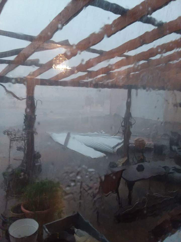
| Unfortunately, the strong outflow winds did cause damage to at least one homestead near Cee Vee, as can be seen below. | |
 |
 |
| Wind damage to a patio, garage and truck that occurred near Cee Vee on the evening of 17 May. The pictures are courtesy of Dana Skinner. | |
| The strongest storm of the evening then intensified near Post and tracked southeastward past Lake Alan Henry. This storm generated a wind gust to 68 mph in Post and went on to produce an 83 mph wind gust at the West Texas Mesonet site near Lake Alan Henry. These strong winds did uproot some trees and caused minor damage to a few structures near Justiceburg, though amazingly, the damage was relatively limited. | |
 |
|
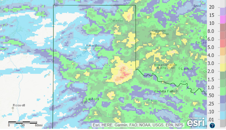
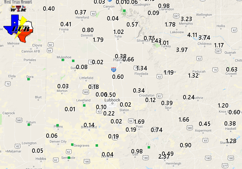
| 7 day radar-estimated and bias-corrected rainfall ending at 7 am on 18 May 2018. A regional presentation of this same information can be VIEWED HERE. A plot of the 6 day rain totals measured by the West Texas Mesonet ending at noon on 18 May 2018 can be ACCESSED HERE. | |
| Although the active mid-May stretch of weather did bring damaging hail and wind in spots, it also brought much-needed and beneficial moisture to the region. As the above plot shows, locations generally north and east of the Highway 84 Corridor fared best, with 1/2" to 1"+ totals common. The southeast Texas Panhandle saw the heaviest rain with 2" to 4"+ falling there. Childress officially recorded 3.66 inches during this active stretch, boosting their yearly total to 4.82 inches. Unfortunately the western South Plains didn't luck out, measuring only light amounts in most spots. | |
|
The Preliminary Storm Reports gather through this stretch of active weather can be found at: |
|

