
A slow moving and vigorous upper level storm system combined with rich Gulf moisture to produce several rounds of severe weather over the southern High Plains. The initial round of severe weather stayed in eastern New Mexico during the afternoon and evening of Monday, May 8th. However, as the storm system edged closer to the region from the west, thunderstorms developed into the western South Plains the next evening.
 |
|
|
Visible satellite animation valid from 1:15 to 4:30 pm on Tuesday, 9 May 2017.
|
|
A couple of particularly intense supercell (rotating) thunderstorms roamed the western South Plains much of Tuesday evening. The most intense storm tracked slowly northeastward from near Morton past Sudan, dropping very large hail and torrential rain as it did so. It also produced several strongly rotating wall clouds and two brief tornadoes, one northeast of Morton and another near Sudan. Thankfully the tornadoes only lasted a few seconds and occurred over open country, so they didn't cause any damage. The largest hail reported back to the NWS was tennis ball sized observed 4 miles south of Enochs. In addition, 2 to 4 inches of rain fell in Muleshoe over a couple of hours, causing widespread street flooding.

The storms didn't call it quits with the setting sun, as is often the case here in West Texas. Instead, increasing lift with the approaching upper level storm system kept clusters of thunderstorms going all night, though they gradually decreased in strength through the early morning hours. One fairly intense storm even blew through Lubbock between 4 and 5 am with strong winds, small hail and a brief but intense downpour.

Below is a picture of the supercell storm as it dropped heavy rain and hail just west of Morton Tuesday evening.

Above and below are several pictures captured Tuesday evening across the western South Plains.
 |
 |
|
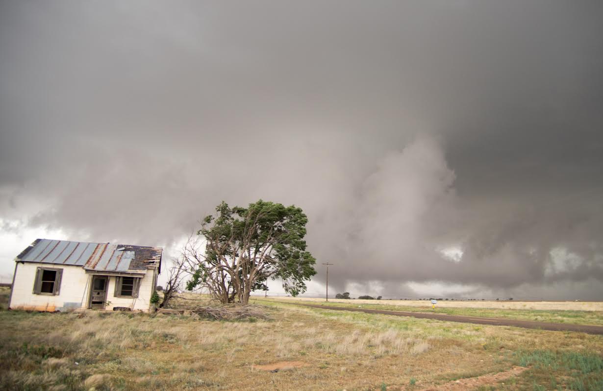
(left) Brief tornado that touched down northeast of Morton Tuesday evening (9 May 2017). The image is courtesy of Timothy Sliwinski. (right) Storm clouds approaching an old homestead on the western South Plains Tuesday evening (courtesy of Mark Conder).
|
|
The thunderstorms did eventually fade shortly after dawn on Wednesday. This lull did not last though as another round of severe thunderstorms quickly redeveloped Wednesday afternoon (10 May 2017) along and ahead of an eastward moving dryline. One particularly intense storm formed over the northeast South Plains and then tracked eastward across the northern Rolling Plains. This storm dropped hail to at least baseball size as it tracked over Cee Vee. It also produced a brief tornado west of Swearingen over open land.

The briefly tornadic storm moved eastward and eventually produced a few more short-lived tornadoes near the Texas and Oklahoma line along the Red River. Additional severe storms formed behind this initial severe storm, dropping baseball sized hail near Brice and golf ball sized hail over parts of Memphis.

The below images show a couple of the larger hailstones that fell across the southeast Texas Panhandle and northern Rolling Plains Wednesday afternoon and evening. The activity eventually shifted eastward out of the area by mid-evening, allowing for a quiet end to the day in West Texas.
 |
 |
|
Hail that fell in Cee Vee (left) and Memphis (right) Tuesday afternoon and evening (10 May 2017). The pictures are courtesy of Neweta Quinn Carroll and Kelli Maddox, respectively.
|
|
Between Tuesday afternoon and Wednesday evening many spots, aside from the southeast South Plains and much of the central and southern Rolling Plains, received some beneficial rains. The heaviest rain was confined to the southwest Texas Panhandle and northwest South Plains where 1 to 4 inches of rain was common. South and east of there rain totals were lighter, though several spots still had upwards of an inch.

Officially the Lubbock Airport recorded 0.45 inches of rain and the Childress Airport received 0.49 inches of rain. The below graphic shows the distribution of the rainfall, as measured by the West Texas Mesonet.
 |
|
|
West Texas Mesonet 2-day rain totals ending at 5 am on Thursday, 11 May 2017.
|
Below are the preliminary local storm reports collected from the WFO Lubbock for May 9th and 10th, 2017:
PRELIMINARY LOCAL STORM REPORT...SUMMARY
NATIONAL WEATHER SERVICE LUBBOCK TX
821 AM CDT WED MAY 10 2017

..TIME...   ...EVENT...      ...CITY LOCATION...     ...LAT.LON...
..DATE...   ....MAG....      ..COUNTY LOCATION..ST.. ...SOURCE....
            ..REMARKS..

0628 PM     WALL CLOUD       4 SSE BLEDSOE           33.57N 102.99W
05/09/2017                   COCHRAN            TX   STORM CHASER

            ROTATING WALL CLOUD... HALF WAY TO THE GROUND.

0730 PM     HAIL             5 S ENOCHS              33.80N 102.76W
05/09/2017  E1.25 INCH       COCHRAN            TX   STORM CHASER

0730 PM     HAIL             4 S ENOCHS              33.82N 102.76W
05/09/2017  M2.50 INCH       COCHRAN            TX   STORM CHASER

0731 PM     HAIL             3 NW RHEA               34.70N 102.99W
05/09/2017  E2.00 INCH       PARMER             TX   FIRE DEPT

            HAIL STACKED UP ON ROOF.

0746 PM     TORNADO          5 SW BULA               33.86N 102.70W
05/09/2017                   BAILEY             TX   STORM CHASER

            BRIEF TORNADO EAST OF ENOCHS. SEVERAL PHOTOS BY STORM
            CHASERS VI SM.

0818 PM     HAIL             6 NNE BULA              33.99N 102.60W
05/09/2017  E2.00 INCH       LAMB               TX   STORM CHASER

0825 PM     FLOOD            3 NE ENOCHS             33.90N 102.72W
05/09/2017                   BAILEY             TX   STORM CHASER

            ROAD FLOODED ALONG WITH HAIL SEVERAL INCHES DEEP.

0829 PM     FUNNEL CLOUD     3 SSW SUDAN             34.03N 102.55W
05/09/2017                   LAMB               TX   STORM CHASER

            POOR CONTRAST PHOTO SHARED VIA SM.

0845 PM     HAIL             2 NW SUDAN              34.09N 102.55W
05/09/2017  E1.25 INCH       LAMB               TX   STORM CHASER

            ESTIMATED FROM PHOTO SHARED ON SM.

0845 PM     TORNADO          1 W SUDAN               34.07N 102.54W
05/09/2017                   LAMB               TX   STORM CHASER

            BRIEF TOUCHDOWN OF ONLY A FEW SECONDS. REPORT VIS SM.

0932 PM     TORNADO          10 SSW LEHMAN           33.49N 102.86W
05/09/2017                   COCHRAN            TX   TRAINED SPOTTER

            ROPE TORNADO JUST WEST OF LOCATION... WEST OF 214.

1047 PM     HAIL             MULESHOE                34.23N 102.73W
05/09/2017  E1.75 INCH       BAILEY             TX   PUBLIC

            LOTS OF QUARTER AND SMALLER HAIL. LARGEST GOLF BALL
            SIZE. PICTURES AND REPORT VIA SM.

1051 PM     HAIL             MULESHOE                34.23N 102.73W
05/09/2017  E1.00 INCH       BAILEY             TX   PUBLIC

            HAIL SLIGHTLY BIGGER THAN A QUARTER.

1054 PM     HAIL             LITTLEFIELD             33.92N 102.33W
05/09/2017  E1.00 INCH       LAMB               TX   POLICE DEPT

            HEAVY RAINFALL ALONG WITH QUARTER SIZE HAIL.

1120 PM     HAIL             5 ENE FIELDTON          34.07N 102.14W
05/09/2017  E1.00 INCH       LAMB               TX   STORM CHASER

1213 AM     FLASH FLOOD      MULESHOE                34.23N 102.73W
05/10/2017                   BAILEY             TX   BROADCAST MEDIA

            WATER COMPLETELY COVERING HIGHWAY 84 THROUGH TOWN.

0351 AM     TSTM WND GST     NEW HOME                33.33N 101.91W
05/10/2017  M64 MPH          LYNN               TX   MESONET

            MEASURED BY WEST TEXAS MESONET.

