
Another round of thunderstorms developed across the Texas South Plains region late in the afternoon on Easter, with the activity increasing in the evening and continuing much of the night. Several of these storms became severe dropping large hail and locally heavy rain, with various storm motions noted. Hail up to the size of tennis balls was reported across portions of Swisher County with the most intense storm that also produced a funnel cloud. Very heavy rain also caused some flooding across Terry and Lynn Counties where storms trained over the area. Check the Local Storm Report summary below to see all the severe weather reports obtained by our office.
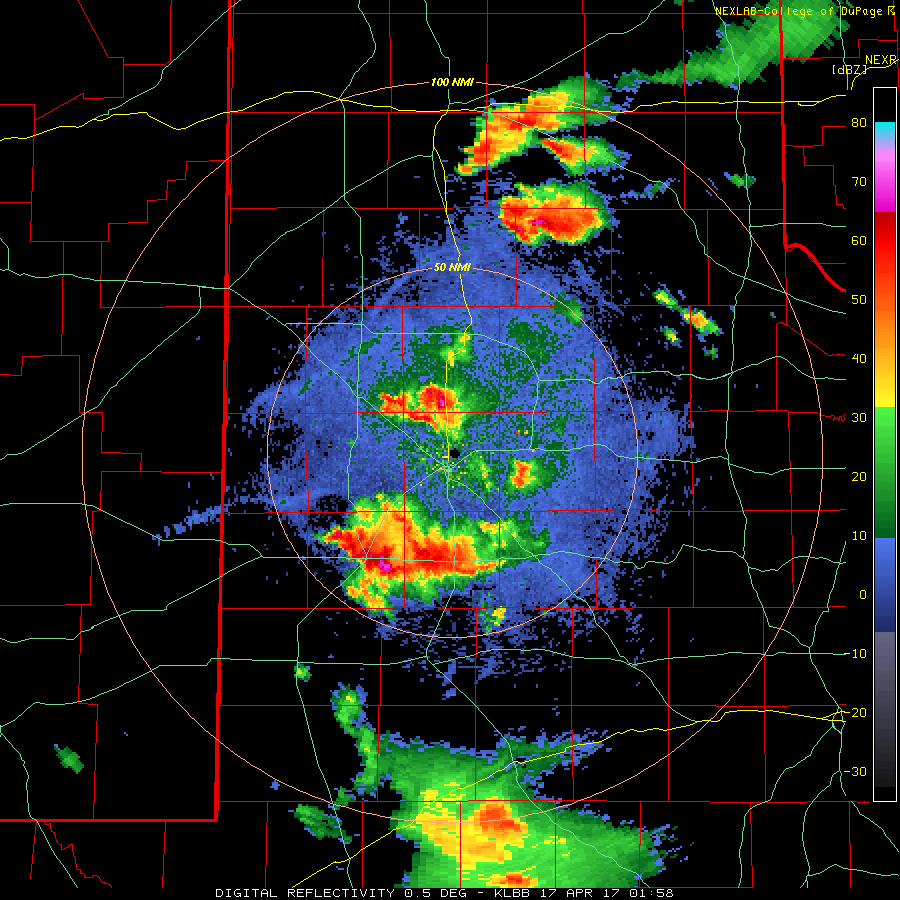
The image below highlights some of the areas that received heavy rainfall from the thunderstorm activity. The dark red to purple and bright blue areas indicate radar-estimated rainfall around three to four inches. The Co-op station in Brownfield reported 3.37 inches of rain. Check the daily temperature and precipitation summary below for more rainfall totals across the area.

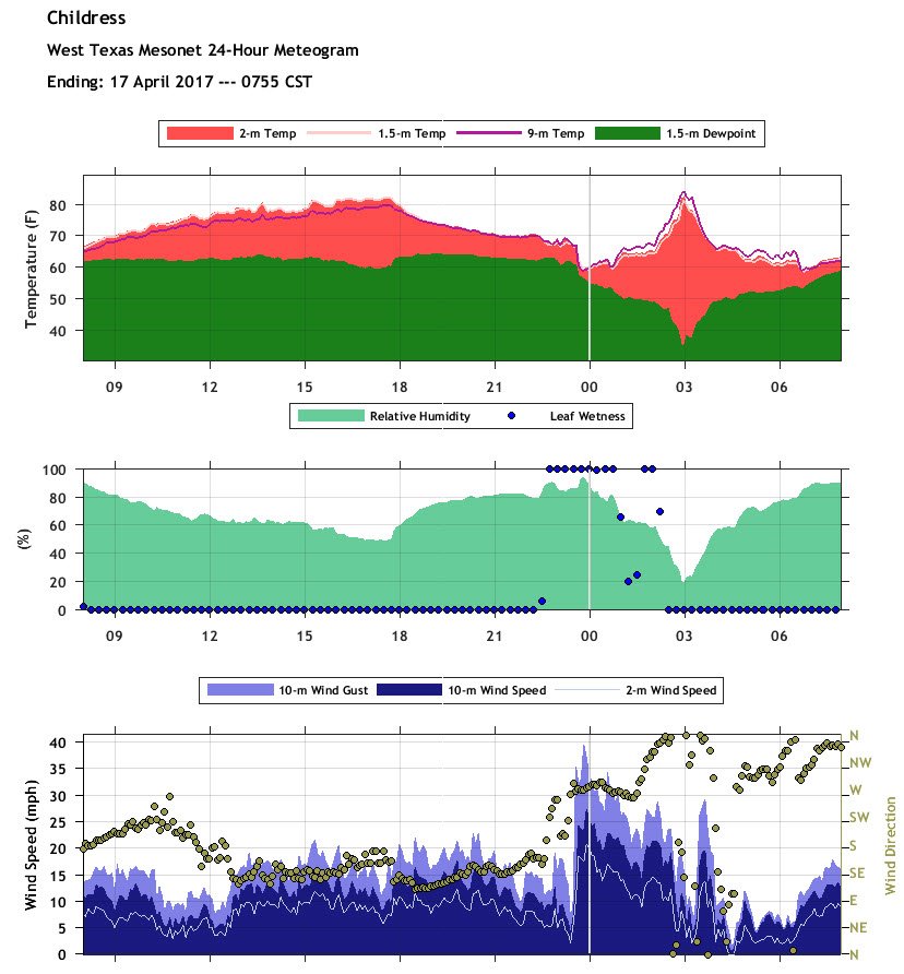
In addition to the wind and hail, the West Texas Mesonet site just north of Childress captured a Heat Burst as the activity was winding down during the early morning hours of the 17th. At 4 am the temperature jumped to 81°, the RH plummeted and shortly thereafter the wind changed direction and gusted to 30 mph. The heatburst is easily visible in the graph below:
Below are two images taken by the new GOES-16 satellite. Click on the images to view a large version. The image on the left is taken from a visible channel and shows the severe thunderstorm complex over the southern South Plains. The image on the right is from an infra-red channel and shows the severe storms near Caprock Canyons State Park late Sunday night. The GOES-16 data is considered experimental and not operational at this time.
 |
 |
| GOES-16 Satellite images from 4/16/2017. Left: Visible satellite image at 7 pm CDT, Right: Infrared image at 11 pm CDT. click on the images to view large versions. | |
A listing of the preliminary local storm report and the COOP precipitation (and temperatures) can be found below.
DAILY TEMPERATURE AND PRECIPITATION SUMMARY
NATIONAL WEATHER SERVICE LUBBOCK TX
924 AM CDT MON APR 17 2017

 THE FOLLOWING DATA ARE FOR THE PREVIOUS 24 HRS (8AM - 8AM)
 HIGHS TYPICALLY FROM THE PREVIOUS DAY.  LOW CAN BE EITHER DAY.

                                                        7-8AM
                      24 HOUR  TODAY   24HR       SNOW  SNOW
  LOCATION            HI  LOW  7-8AM   PCPN       FALL  DEPTH
 Abernathy            84   52   53     0.07
 Aspermont            84   59   59     0.03
 Big Spring AWOS      83   58   58
 Brownfield           86   50   50     3.37
 Childress            84   59   59     0.31
 Childress ASOS       82   60   61     0.28
 Crosbyton            84   54   54
 Denver City          86   53   53
 Dimmitt              78   47   47
 Floydada             84   55   55       T
 Friona               80   47   48
 Guthrie              85   57   57
 Hart                 80   46   49
 Jayton               87   59   59
 Lamesa               83   52   52
 Lake Alan Henry       M    M    M        M
 Levelland            83   52   52     0.04
 Littlefield 5SE      86   48   50
 Lubbock              84   52   53       T
 Matador              82   54   60        M
 Memphis              81   60   60       T
 Morton               86   52   53
 Muleshoe             82   44   48
 Muleshoe Refuge       M    M    M
 Olton                83   51   51       T
 Paducah              82   58   61
 Paducah 15S (Grow)   81   59   60
 Plainview Wtr Plnt   83   52   52     0.30
 Plainview Dly Hrld   85   53   54     0.32
 Plains               87   50   53
 Post                 87   55   56     1.15
 Silverton            81   49   56     1.09
 Snyder               81   58   59
 Spur                 83   54   54     0.03
 Tahoka               85   53   54     1.12
 Tulia                80   49   49     0.18
 Turkey               85   54   59     0.60
 Vigo Park            82   58   59     0.38
 White River Lake     82   55   58

  AUTOMATED STATIONS                   HIGH LOW  7AM    RAIN
 Muleshoe Wildlife Refuge                83  42   50
 Caprock Canyons State Park RAWS         84  54   56    0.99
 Jayton RAWS                             83  59   59

 The following mesonet data show 24hr highs and lows
 and precipitation 8am-8am.

 Texas Tech West Texas Mesonet...
                      24-HR   8AM   8AM-8AM
                      HI LOW
 Abernathy 5NE        84  52   53     0.07
 Aiken 3WSW           85  51   54     0.18
 Amarillo 7SSE        79  46   51
 Amarillo 9NNE        80  46   48
 Amarillo 15NNW       79  50   51
 Amherst 1NE          83  48   51
 Andrews 2NE          86  54   56     0.06
 Anton 6S             85  50   54
 Aspermont 3NE        85  59   61     0.03
 BBNP Persimmon Gap   91  54   58     0.95
 Big Lake 1WNW        79  55   55     0.09
 Bootleg 11WNW        77  45   52
 Boys Ranch 1WSW      75  48   51
 Brownfield 2S        84  54   57     0.78
 Canadian 6E          80  56   56     0.22
 Caprock Canyons      84  51   54     1.23
 Childress 2NNE       82  59   60     0.56
 Clarendon 2WSW       82  49   55
 Claude 12SW          81  50   52     0.14
 Clyde  2WNW          77  63   63
 Coyanosa             92  55   56
 Crowell 1E           82  60   60
 Dell City 1N         89  42   46
 Denver City 7W       86  49   52
 Dimmitt 2NE          78  48   50
 Dora NM 2SW          82  51   54
 Dozier 2W            81  60   62
 Floydada 2NE         84  50   51     0.09
 Fluvanna 3W          82  56   58
 Fort Chadborne        M   M    M        M
 Fort Lancaster       82  56   57
 Fort Lewis CO        66  33   40
 Fort McKavett        79  56   56     0.30
 Friona 2NE           76  46   48
 Gail 2SE             84  53   55
 Goodlett 3W          83  58   61     0.04
 Goodnight            84  50   54     0.18
 Graham 5SW           82  54   57     0.76
 Guadalupe N.P.       80  48   49
 Guthrie 10W          83  58   60
 Hart 3N              82  48   50
 Haskell 1NW          81  62   62     0.33
 Hereford 2NW         76  47   50
 Hobbs NM 5NW         89  55   56
 Jayton 1S            82  58   59
 Junction 1SSW        81  58   60     0.06
 Knox City 3NW        82  58   59
 Lake Alan Henry 1NW  85  56   58     0.41
 Lamesa 2SE           83  53   54
 Levelland 4S         83  49   53
 Lomax 1SSE           86  57   57     0.05
 Lubbock (TX Tech)    84  51   53
 Lubbock (Reese Ctr)  82  50   52
 McLean 1E            80  58   60
 Memphis 1NE          81  59   60
 Menard 2NWE          77  58   59     0.02
 Mertzon 3NNE         79  55   56     0.04
 Morton 1NE           85  53   55
 Muleshoe 2S          82  44   48
 New Home             84  51   52     0.07
 Northfield 1S        83  57   58     0.87
 O`Donnell 1N         83  53   54     0.03
 Olton 6S             83  49   50     0.18
 Odell 4ENE           81  60   64
 Paducah 10SW         82  59   60
 Palo Duro Canyon Rim 82  51   53     0.21
 Palo Duro Cnyn Floor 87  52   52     0.32
 Pampa 2E             81  52   53
 Panhandle 1SSW       80  49   55
 Plains 3N            86  51   54
 Plainview 1S         83  51   54     0.28
 Post 1NE             84  56   58     0.92
 Ralls 1SE            81  53   54
 Roaring Springs 3N   82  54   60     0.03
 San Angelo 7NW       79  57   58
 Seagraves 1SW        85  53   57
 Seminole 2N          87  52   54
 Seymour 3NW          82  60   64
 Sierra Blanca 1SSE   86  56   56
 Silverton 7E         83  50   53     0.90
 Slaton 2NE           81  52   54     0.03
 Snyder 3E            84  57   59
 Snyder 3SSW (WTC)    82  57   59
 Spur 1W              82  55   55     0.02
 Stamford 5ESE        83  61   64     0.01
 St Lawrence 5SW      84  55   56     0.08
 Sterling City 4WNW   82  56   58     0.02
 Sundown 8SW          85  49   53     0.03
 Sweetwater 11SW      80  58   59
 Tahoka 3NE           84  51   55     0.61
 Tarzan 2WNW          86  56   56     0.08
 Tatum NM 2SW         86  48   51
 Throckmorton 1SW     82  63   65
 Tulia 2NE            82  48   51     0.11
 Turkey 2WSW          84  54   56     0.98
 Umbarger 3NNE        78  47   51
 Vigo Park            82  46   53     0.38
 Wall 1E              82  58   59     0.22
 Weinert 2NNE         84  59   62
 Welch                86  55   57
 White River Lk 6NW   83  56   59
 Wolfforth 6SW        83  52   53     0.01

SUPPLEMENTAL PRECIPITATION..
 Childress USDA (Childress Cnty)     0.31
 Childress 7NW  (Childress Cnty)     1.95
 Dodson 5S      (Childress Cnty)        M
 Kirkland 1W    (Childress Cnty)        M
 Dumont         (NW King County)        M
 Floydada 9SE     (Floyd County)     0.02
 Flomot 2E    (NW Motley County)     0.08
 Flomot 4NE   (NW Motley County)     0.22
 Lubbock 9N     (Lubbock County)     0.04
 Lubbock 7WSW (77TH NR Iola)            M
 Lubbock 7SW  (90TH NR Slide)        0.03
 Lubbock 7SW #2 (103RD NR Slide)        M
 Northfield   (NE Motley County)     0.71
 Roaring Springs (Motley County)       T
 Ropesville 6NNW(Hockley County)     0.29
 Shallowater    (Lubbock County)     0.04
 Slaton         (Lubbock County)       T
 Tell 3S        (Childress Cnty)     0.75
 Woodrow 3W  (154th & Indiana)          M

  ..Automated USGS RAIN-ONLY Gauges..
 Brice 6SW        (Hall County)      0.77
 Childress 10N(Childress County)     0.02
 Justiceburg(Garza County)           0.45
 Lake Alan Henry (Garza County)      0.35
 Mackenzie Lake (Briscoe County)     1.36
 Wayside (Armstrong County)          0.08

