
On Friday afternoon, April 14, 2017, thunderstorm cells develop across central Parmer County, dropping large hail in the vicinity of Bovina, Texas. By late afternoon, the cells organized into a supercell thunderstorm over eastern Parmer and western Castro County. Over the course of the next 3-4 hours, the supercell moved very slowly north and east, producing several tornadoes, large hail and damaging winds, mainly across west-central Castro County. A large tornado was observed just west of Dimmitt, which produced up to EF-3 damage to several structures (see the Public Information Statement issued by our office below). The supercell eventually moved southeast into Hale Country Friday night, continuing to produce severe weather, including large hail in Plainview.
EF-3 Tornado near Dimmitt, Texas |
||||||||||||||
|
 |
 |
|
(Left) Tornado photographed at 5:59 pm from the intersection of FM 145 and FM 1055, looking northwestward. Tornado is about 6 miles north of Lazbuddie.(Right) Multi-vortex tornado with one satellite funnel/tornado visible at 6:27 pm. Picture is looking north-northwest from FM 145 about 2 miles west of US 385. Both images are from Mark Conder.
|
|
The map below shows the preliminary local storm reports received by our office from the storms on April 14th. Scroll down toward the bottom of this page to see a detailed list of the reports.

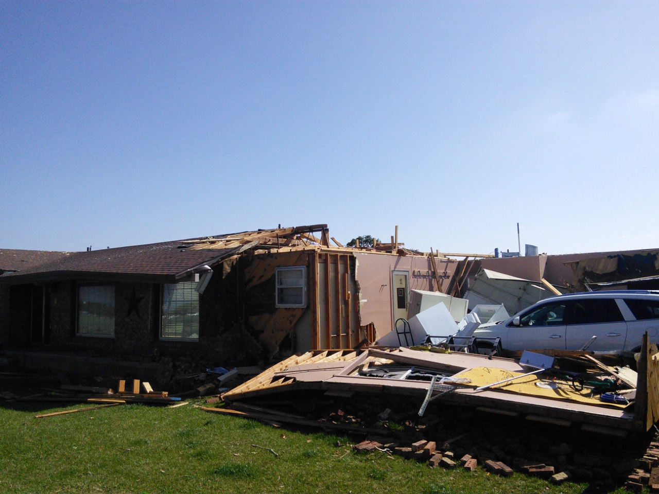
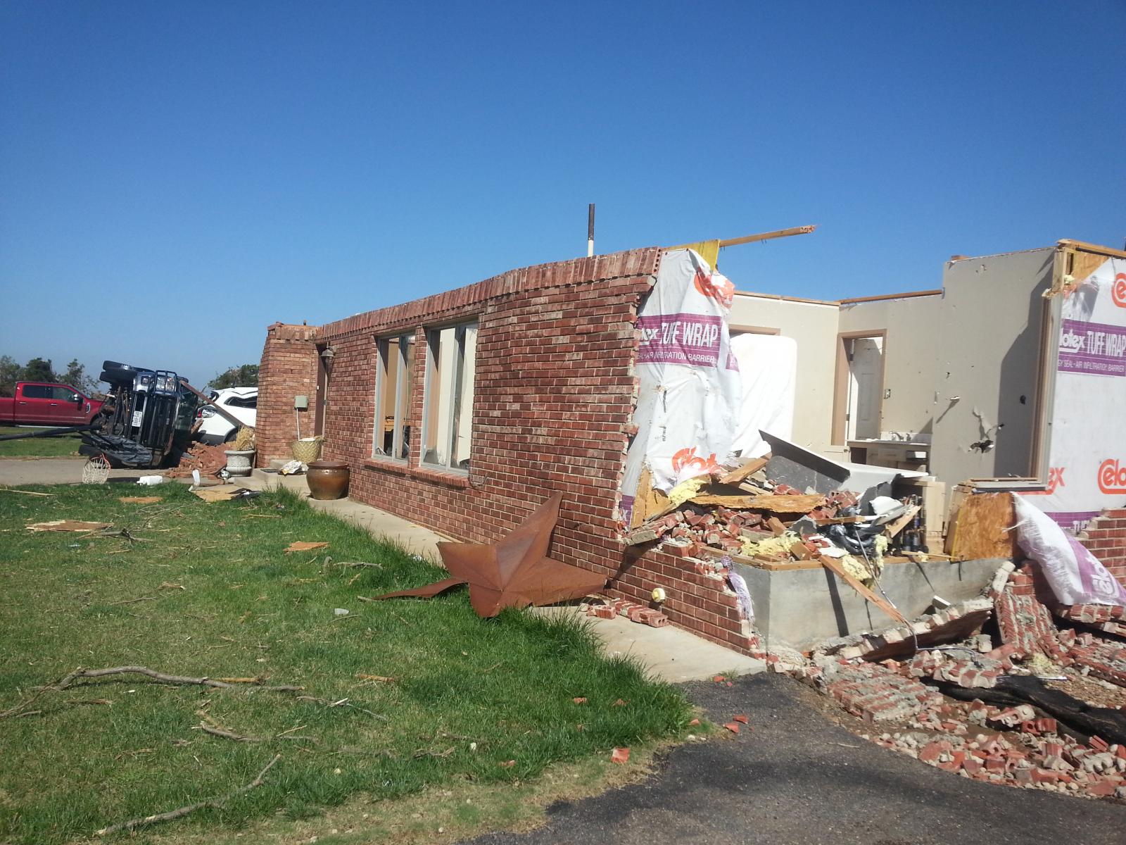
Below are four examples of the damage recorded by the NWS Lubbock damage survey to the west and northwest of Dimmitt. To view the complete damage survey results go to this NWS Damage Assessment Viewer (DAT). Once on the DAT page select "Lubbock" for your Office ID. Then select a begin date of 04/14/2017 and an end date to 04/16/2017 toward the top right of the page and click "Filter". At this point the relevant damage survey points west and northwest of Dimmitt should be visible. You can then zoom in and select the points to view more details and images.
 |
 |
|
Two photos of damage sustained from the major tornado west of Dimmitt. Click on each photo to view the full-sized image.
|
|
 |
 |
|
Two additional photos of damage sustained from the major tornado west of Dimmitt. Click on each photo to view the full-sized image.
|
|
The below radar animation shows the evolution of the Castro County supercell. The storm formed over Parmer County, but then spent most of the evening hours over Castro County before finally accelerating southeastward through the late evening and overnight hours. A couple of other storms did form in the region during the late afternoon and evening hours, but the storm that sat near Dimmitt for several hours was by far the strongest and longest-lasting.

The image below is a snapshot of the high-resolution GOES-16 imagery from the Castro County supercell during the evening hours.

UBLIC INFORMATION STATEMENT
NATIONAL WEATHER SERVICE LUBBOCK TX
917 PM CDT Sat Apr 15 2017

...NWS Damage Survey for the April 14, 2017 Castro County Tornado
Event...

Rating: EF-3
Estimated Peak Wind: 140 MPH

Path length: 4.5 Miles
Path width: 1.1 Miles
Fatalities: 0
Injuries: 0

Start date: 04-14-2017
Start time: 630PM (Approx)
Start location: Dimmitt, TX 4.7SW
Start Lat/Lon: 34.512 -102.381

End date: 04-14-2017
End time: 650PM (Approx)
End location: Dimmitt, TX 3NW
End_lat/lon: 34.572 -102.359

Meteorologists with the National Weather Service in Lubbock
conducted a storm damage survey in Castro County on April 15.
This team surveyed damage across western and northern portions of
the county guided by radar data, local law enforcement, and
available streaming video during the event.

The storm associated with this event was a long duration supercell
which was tracked over about a 9 hour period and affected portions
of Parmer, Castro, Swisher, Hale, and Floyd counties.

The first indications of tornado development occurred around 605
PM about 12 miles southwest of Dimmitt. Numerous brief tornadoes
occurred as the storm moved toward the City of Dimmitt. The
absence of damage indicators across rural western Castro County
precluded determination of any path or intensity estimates.
Streaming video suggested that at least 5 brief tornadoes formed
across western Castro county with some exhibiting multi-vortex
characteristics.

The main tornado with this event exhibited a path of approximately
4.5 miles on a north-northeasterly track. The most significant
damage observed was located about three miles west of Dimmitt
where a metal systems building was completely destroyed. The
remnants were displaced several hundred feet northwest of the
original site. This corresponds with a maximum damage rating of
EF-3. Several nearby homes received up to EF-2 damage. Elsewhere
along the path, a lack of damage indicators made classification
difficult though numerous power poles and center pivots were
damaged. Streaming video of the event at its peak suggested a
large wedge type tornado with satellite vortices.

Additional damage occurred north of the city of Dimmitt in an area
under the parent mesocylone. The few damage indicators in this
area resulted in an inconclusive determination of tornado vs.
straight line winds. The city of Dimmitt received damage to power
poles consistent with straight line winds.


EF Scale:  The Enhanced Fujita Scale Classifies Tornadoes into
the following categories.

EF0...Weak......65 to 85 MPH
EF1...Weak......86 to 110 MPH
EF2...Strong....111 to 135 MPH
EF3...Strong....136 to 165 MPH
EF4...Violent...166 To 200 MPH
EF5...Violent...>200 MPH

Note:
The information in this statement is preliminary and subject to
change pending final review of the event and publication in NWS
Storm Data.

