| Two Days of Wind, a Round of Thunderstorms, and Blowing Dust 23-24 March 2017 |
|
 |
|
| A dusty West Texas sky during the afternoon of 23 March 2017 (Thursday). The image is courtesy of KAMC. | |
| The approach and passage of a potent upper level storm system brought two days of strong winds to West Texas (23-24 March), along with a round of quick moving showers and thunderstorms during the evening of the 23rd. Southerly winds started early and continued to crank up during the day Thursday as an intensifying spring storm system approached through the southern Rockies. The prolonged period of southerly winds generally sustained at 30 to 40 mph, with gusts well into the 50s, lofted a fair amount of dust on the Caprock which painted a brown skyline from late Thursday morning into the evening hours. | |
 |
|
|
Daytime true(ish) color satellite image captured by GOES-16 at 5:32 pm on 23 March 2017. The GOES-16 data posted on this page are preliminary, non-operational data and are undergoing testing. Users bear all responsibility for inspecting the data prior to use and for the manner in which the data are utilized. |
|
| The dust dropped the visibility to 4 to 6 miles at times over the South Plains Thursday afternoon. Even greater amounts of dust were lofted over Far West Texas into southeast New Mexico during this same time as strong westerly winds overspread this region behind an advancing Pacific cold front. The visibility dropped below 1 mile at times in El Paso up toward Alamogordo. The above satellite image clearly shows north-to-south bands of blowing dust (brownish tint) over parts of the South Plains, with a large plume of dust over Far West Texas and south-central New Mexico. | |
 |
|
| Regional radar animation valid from 6:48 pm to 7:58 pm on 23 March 2017. An earlier radar animation valid from 5:18 pm to 6:28 pm can be VIEWED HERE. | |
| The southerly winds carried just enough moisture into the region to provide fuel for showers and thunderstorms to develop as the Pacific front encountered the better moisture and instability. Thunderstorms quickly formed near the Texas/New Mexico line Thursday evening. The individual storms raced northeastward at 60+ mph while the broken line moved eastward through early Friday morning. | |
 |
|
| View of developing thunderstorms, looking west of Lubbock during the evening of 23 March 2017. | |
| The limited moisture/instability kept most of the activity from getting too intense, though a few spots did still see small hail with plenty of wind to go around (though not much stronger than the winds that had been in place through much of the day). Although moderate to heavy downpours did accompany the thunderstorms, the fast storm motion kept rain totals on the light side in any given spot. | |
 |
|
| Regional radar animation valid from 8:18 pm to 9:28 pm on 23 March 2017. An additional animation valid from 9:18 pm to 10:28 pm can be VIEWED HERE. | |
| After the Pacific cold front moved through during the evening and overnight hours drier air quickly moved in on gusty westerly wind. These winds increased again on Friday as the center of the storm system (which is readily apparent in the below satellite image) tracked across the Texas Panhandle and into western Oklahoma. The winds eventually turned northwesterly on the back side of the storm system but remained quite windy into Friday afternoon and evening before finally letting up by early Saturday. | |
 |
|
| Daytime true(ish) color satellite image captured by GOES-16 at 4:57 pm on 24 March 2017. The GOES-16 data posted on this page are preliminary, non-operational data and are undergoing testing. Users bear all responsibility for inspecting the data prior to use and for the manner in which the data are utilized. Regional radar animations captured Friday can also be viewed at: Friday morning (9:18 to 10:28 am 24 March) and Friday afternoon (4:08 to 5:18 am 24 March). | |
| The wound up storm system did spill clouds from the Texas Panhandle into the South Plains and Rolling Plains on Friday. A few of these clouds even dropped a few sprinkles and light showers, though additional rain totals were very light, from a trace to hundredth of an inch. | |
 |
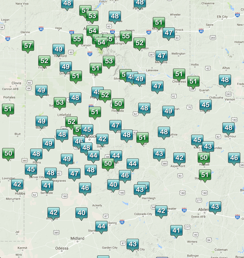 |
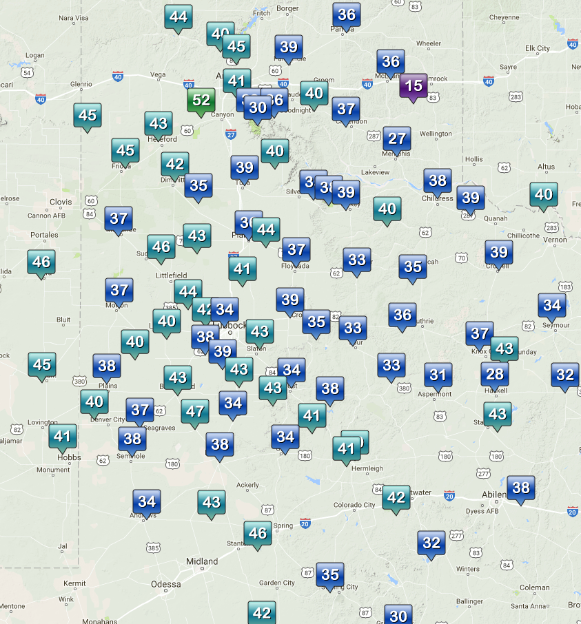
| Maximum wind gusts (mph) recorded on the 23rd (left) and 24th (right) of March 2017. The data are courtesy of the West Texas Mesonet. To view the maximum sustained winds click on the following links: March 23rd and March 24th. | |
| The above plots show the maximum wind speeds recorded both Thursday and Friday. In general, the winds were a little strong across most of the South Plains region Thursday than on Friday, but regardless it was a couple of windy days. Officially the Lubbock International Airport has a maximum wind gust of 54 mph on Thursday and 52 mph on Friday. | |
 |
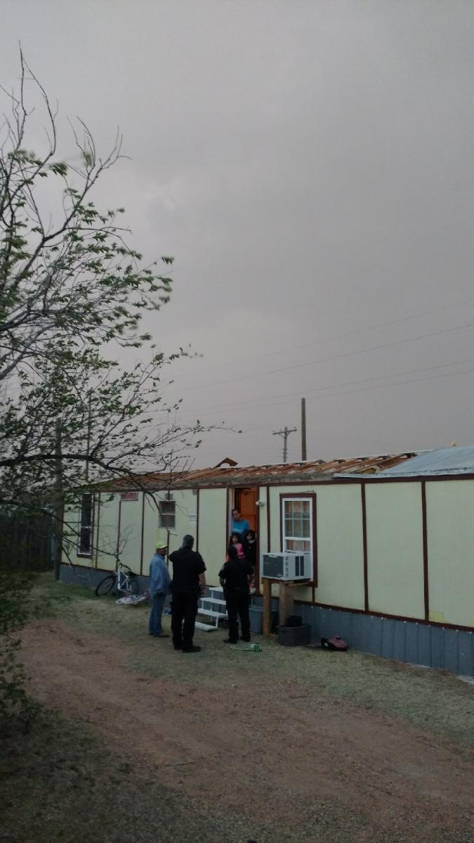 |
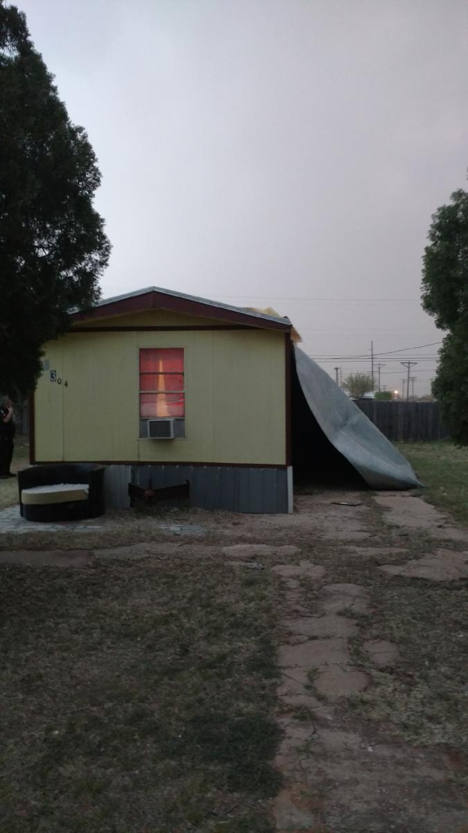
| Wind damage sustained to a mobile home in Levelland on 23 March 2017. The pictures are courtesy of Gee Golightly. | |
|
Unfortunately the strong winds did cause damage in a few spots. In addition to knocking down many twigs and small branches, the wind removed a roof from a mobile home in Levelland Thursday. The winds that caused this damage were not associated with any thunderstorms, but the intense southerly gradient winds during the afternoon and evening hours. The preliminary storm reports for this event can be found at: |
|
 |
|
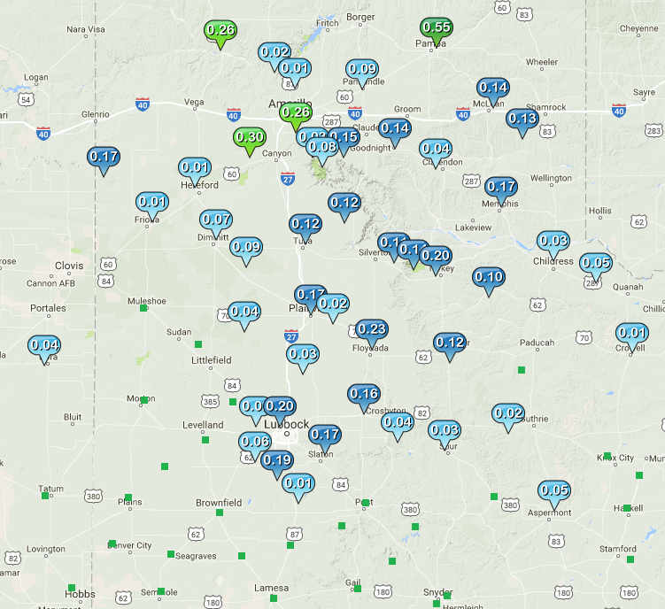
| Radar-estimated and bias-corrected 24-hour rainfall totals ending at 7 am on 24 March 2017. Observed rainfall totals from the West Texas Mesonet over this same period can be FOUND HERE. | |
| As alluded to earlier, the quick storm motions kept rainfall totals light. Even so many locations saw at least a little rain, with totals of a few hundredths to a couple tenths of an inch fairly common. A few spots also saw brief periods of pea to dime size hail accompany the downpours, including in and around Lubbock. The system did also drop generous snow totals over portions of the central and southern Rockies. The below satellite animation nicely illustrates the vast amounts of dust in the air over the southern High Plains on Thursday, with plenty of moisture being drawn into Colorado and northern New Mexico toward the end of the animation, when the heavy snows fell there. | |
|
|
|
| Daytime color enhanced composite satellite animation captured by GOES-16 on Thursday, 23 March 2017. The pink represents areas of dust, with brown indicating cloud cover. The GOES-16 data posted on this page are preliminary, non-operational data and are undergoing testing. Users bear all responsibility for inspecting the data prior to use and for the manner in which the data are utilized. | |

