| Wet and Cool Mid-February Stretch 13-14 February 2017 |
 |
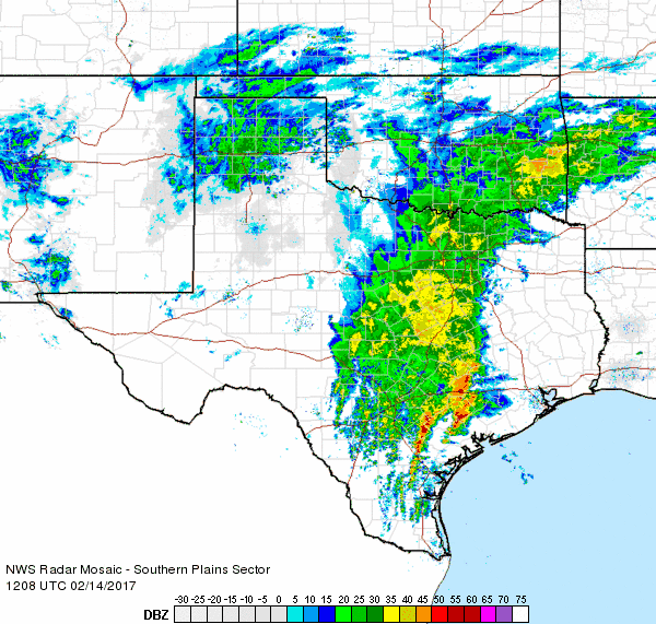
| Regional radar animation valid from 10:38 am to 11:48 am on Monday, 13 February 2017. To view a radar animation valid from 6:28 am to 7:38 am on Monday CLICK HERE. |
| After a record warm stretch of mid-February weather, things took a dramatic turn as a large western storm system approached. One portion of the system split off and moved by well to our north sending a cold front southward through the South Plains early Sunday morning (12 February). The initial frontal passage was a dry one though it did drop temperatures back toward average as gusty northerly winds carried in much cooler air after the record heat the previous two days. Eventually the second portion of the western storm, in the form of a closed upper level low, began to approach on Monday. As it did so it carried in abundant moisture and showers and thunderstorms blossomed over the region Monday morning (13 February). |
 |
| Regional radar animation valid from 4:48 pm to 5:58 pm on Monday, 13 February 2017. To view a radar animation valid from 10:28 pm to 11:38 pm on Monday CLICK HERE. |
| Areas of showers and thunderstorms continued through the day Monday. Early on, temperatures were at or just below the freezing mark across the southwest Texas Panhandle into the northwest South Plains. This did result in pockets of freezing rain and sleet Monday morning. Thankfully the relatively warm ground and marginal air temperatures kept impacts to a minimum. Widespread light to moderate rain continued through much of Monday before eventually shifting eastward Monday night. |
 |
| Snow falling on I-27 in Amarillo on Tuesday, 14 February 2017. Image is courtesy of TXDOT. |
| Precipitation did increase again along and north of the track of the upper low as it emerged over West Texas on Tuesday (14 February). Where temperatures were cold enough, the rain changed to snow over portions of the Texas Panhandle and northern South Plains. The brunt of the snow was focused through the central Texas Panhandle where 1 to 3 inches of snow was fairly common, though a few pockets of heavier snow also occurred further south. |
 |
| Regional radar animation valid from 6:08 am to 7:18 am on Tuesday, 14 February 2017. |
| The visible image below captured after the snow ended and skies cleared early Wednesday morning (15 February) nicely illuminate where the heavier snow accumulations occurred. In particular, spots near and northwest of Dimmitt and in and north of Silverton saw the accumulating snow with 2 inches of snow officially recorded at each site. |
 |
| Visible satellite image captured at 8:45 am on Wednesday, 15 February 2017. Areas of snow can be seen in pockets across the southern Texas Panhandle. |
| The snow did create a few slick spots Tuesday into early Wednesday over portions of the Texas Panhandle, but the more widespread theme was the beneficial moisture that fell over the region. Rainfall totals of 1 to 2+ inches were common from the eastern South Plains through much of the Rolling Plains and southeast Texas Panhandle. The rain totals were lighter further west, but still significant for this time of year, with amounts near and in excess of a half inch for much of the remainder of the South Plains and southwestern Texas Panhandle. |
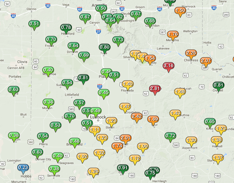 |
| West Texas Mesonet 5-day rain totals ending at midday on Friday, 17 February 2017. |
| Officially the Lubbock Airport recorded 0.89 inches of rain between February 13th and 14th, the first measurable rain of the month. This instantly catapulted the monthly rainfall above average and boosted the yearly rainfall to an impressive 2.92 inches (or just shy of 2 inches above average through February 14th). Even more impressive, Childress officially recorded 2.50 inches over the two-day event and their yearly rainfall jumped to 4.22 inches (nearly 3 inches above average to this point). This put both Lubbock and Childress in the top 5 wettest starts to the year. Of course the winter months are typically the dry time of year. If the periodic rain doesn't continue into spring and summer it will all be a moot point. Let's hope this isn't the case and just enjoy the rain while we have it! |
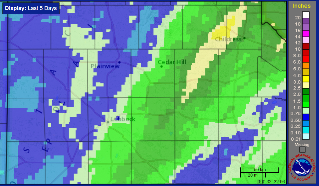 |
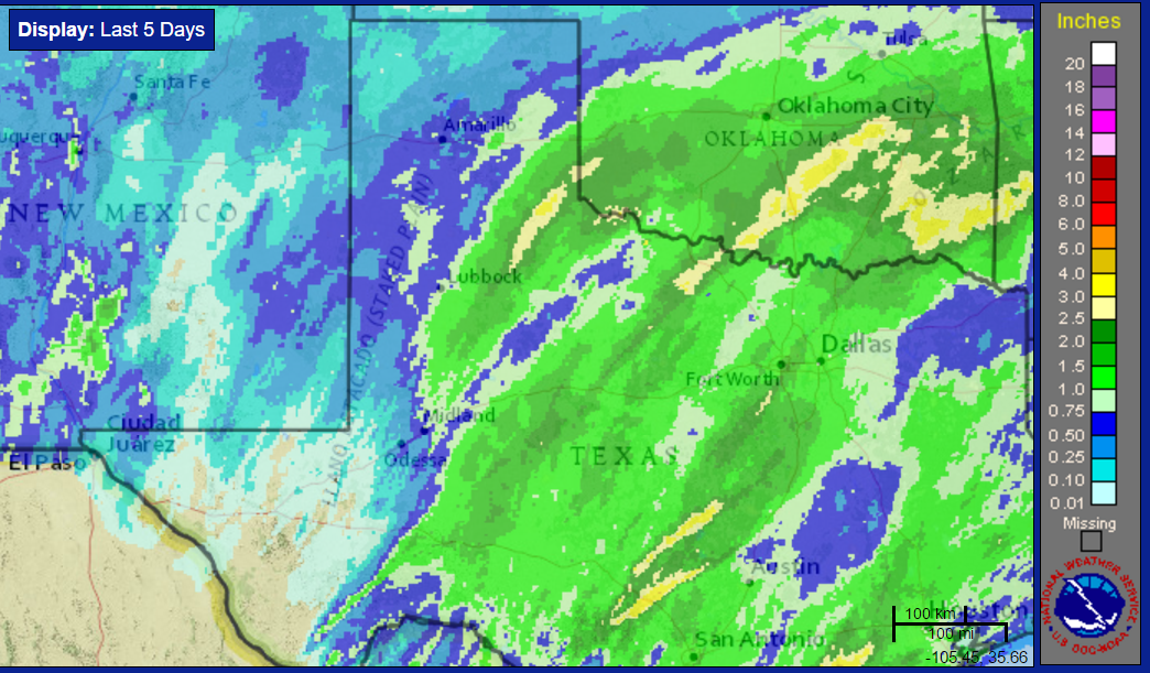
| Radar-estimated and bias-corrected 5-day rain totals ending at 10 am on Friday, 17 February 2017. For a regional view of the same product CLICK HERE. |

